National Spatial Data Infrastructure Strategic Plan 2021-2024 - November 2020
←
→
Page content transcription
If your browser does not render page correctly, please read the page content below
National Spatial Data Infrastructure
Strategic Plan
2021–2024

                                 November 2020
Federal Geographic Data Committee

Federal Geographic Data Committee, Reston, Virginia: 2020

For more information on the Federal Geographic Data Committee
World Wide Web: http://www.fgdc.gov/
E-mail: fgdc@fgdc.gov

Any use of trade, product, or firm names is for descriptive purposes only and does not imply endorsement by the
U.S. Government.

Although this report is in the public domain, permission must be secured from the individual copyright owners to
reproduce any copyrighted materials contained within this report.

Suggested citation:
Federal Geographic Data Committee, 2020, National Spatial Data Infrastructure Strategic Plan 2021–2024:
Reston, Virginia, USA, Federal Geographic Data Committee, 17 p., https://www.fgdc.gov/nsdi-plan/nsdi-strategic-
plan-2021-2024.pdf.

Cover: Artist's depiction of global communications and digital connections. Courtesy of Blue Planet Studio/
Shutterstock.com; used with permission.
Contents
Executive Summary................................................................................................................................ 1
Introduction............................................................................................................................................. 3
      What Are Geospatial Data and Why Are These Data Important to the Nation? .............................. 3
      What Is the National Spatial Data Infrastructure? ........................................................................... 3
      How Is the NSDI Being Advanced? ................................................................................................. 4
      Purpose of the NSDI Strategic Plan ................................................................................................ 4
Shared Vision, Mission, and Guiding Principles ..................................................................................... 5
Strategic Goals and Objectives .............................................................................................................. 6
      Goal 1—Implement the National Geospatial Policy and Governance Framework as Defined
             by the Geospatial Data Act and Related Statutes and Policies......................................... 7
      Goal 2—Advance the Maturity of, Accelerate the Acquisition of, and Expand the Sources of
             National Geospatial Data Assets To Ensure That They Are Findable, Accessible,
             Interoperable, and Reusable............................................................................................. 8
      Goal 3—Ensure Open Standards-Based Interoperability To Enable Geospatial
             Shared Services................................................................................................................ 9
      Goal 4—Enable and Promote Collaborative Governance and Partnerships To Meet National
             Needs, Priorities, and Circumstances ............................................................................. 10
Implementation Approach......................................................................................................................11
      Implementation Framework............................................................................................................11
      Agency Responsibilities .................................................................................................................11
      Measuring Progress ...................................................................................................................... 12
      Initial Implementation Milestones .................................................................................................. 13
Summary of Expected Results ............................................................................................................. 13
References Cited.................................................................................................................................. 14
Appendix............................................................................................................................................... 15
      FGDC Member Agencies .............................................................................................................. 15
      National Geospatial Advisory Committee ...................................................................................... 15
      List of Authorities ........................................................................................................................... 16
      Abbreviations................................................................................................................................. 17
      Acknowledgments ......................................................................................................................... 17

Figure
1.    Overview of National Spatial Data Infrastructure planning ............................................................ 12

 www.fgdc.gov                                                            National Spatial Data Infrastructure Strategic Plan • 2014–2016            |   i
Executive Summary
Executive Summary
Geospatial data, technologies, and services have become critical components of our Nation’s digital infrastructure, enabling
the integration of disparate information from many sources to drive economic growth and support decision making across
broad sectors of the economy. The Geospatial Data Act of 2018 (GDA) directs the Federal Geographic Data Committee
(FGDC) to develop a strategic plan for the National Spatial Data Infrastructure (NSDI) to provide strategic direction to
support and leverage these advancements.
The strategic plan for the NSDI for 2021 through 2024 describes the actions the FGDC community will take, in collaboration
with partners, to develop and maintain the Nation’s critical geospatial infrastructure and to implement the requirements
of the GDA. This strategic plan was developed during 2020 through extensive consultation with Federal agencies, the
National Geospatial Advisory Committee, and partners and stakeholders across the geospatial community. This external
input was instrumental in shaping the plan and in reflecting the perspectives of the broader geospatial community.
This plan describes a shared national vision, mission, and guiding principles for the NSDI.
NSDI Vision: Empowering a geo-enabled Nation and world for place-based decision making.
NSDI Mission: The NSDI provides a national network of geospatial resources that seamlessly integrates location-based
information to serve the needs of the Nation and wider global interests.
The plan also includes goals, objectives, and anticipated outcomes in areas of critical importance to the sustainable
development of the NSDI. The goals and objectives are as follows:
Goal 1—Implement the National Geospatial Policy and Governance Framework as Defined by the Geospatial Data
Act and Related Statutes and Policies
• Objective 1.1. Align FGDC policies with the GDA, the Federal Data Strategy, the Evidence Act, and
Office of Management and Budget Circular A–16.
• Objective 1.2. Develop FGDC guidance for agencies to implement GDA requirements.
• Objective 1.3. Identify common approaches and tools to meet GDA and related planning and
reporting requirements.
• Objective 1.4. Review and update FGDC structure and governance processes to incorporate best practices and
to align with the GDA and related statutes and policies.
Goal 2—Advance the Maturity of, Accelerate the Acquisition of, and Expand the Sources of National Geospatial
Data Assets (NGDA) To Ensure That They Are Findable, Accessible, Interoperable, and Reusable
• Objective 2.1. Update, validate, and streamline NGDA portfolio management practices and establish standards
for NGDA data themes and associated datasets.
• Objective 2.2. Implement data acquisition and lifecycle management strategies through collaboration and
ongoing outreach.
• Objective 2.3. Advance the practice of integrating government and nongovernment data into national datasets.
• Objective 2.4. Identify, validate, and advance best practices to ensure that geospatial and other meaningful data
can be easily integrated and used.
www.fgdc.gov National Spatial Data Infrastructure Strategic Plan • 2021–2024 | 1Goal 3—Ensure Open Standards-Based Interoperability To Enable Geospatial Shared Services
• Objective 3.1. Increase awareness and broaden the use of national shared services, including the GeoPlatform,
to publish, discover, integrate, promote, visualize, analyze, and disseminate national geospatial data. Apply open
standards to ensure that shared services can be improved and expanded at minimal effort and cost.
• Objective 3.2. Identify and test innovative information sources and technologies—including real-time data from
fixed and mobile sensors, social media, and the Internet of Things—to improve national geospatial shared
services capabilities.
• Objective 3.3. Update shared services policies and practices to improve the ability of users to discover, qualify,
access, combine, and use geospatial services with geospatial data, spatial analytics, and nonspatial data.
• Objective 3.4. Engage with international standards organizations to ensure the continued development of a robust
and effective level of interoperability to enhance geospatial data sharing, integration, and technology adoption.
Goal 4—Enable and Promote Collaborative Governance and Partnerships To Meet National Needs, Priorities, and
Circumstances
• Objective 4.1. Collaboratively define priorities, roles, and responsibilities for the development of the NSDI as
described in the GDA.
• Objective 4.2. Develop processes and tools, in collaboration with partners, to promote effective communication
and knowledge exchange about the benefits and uses of geospatial data, technology, and the NSDI.
• Objective 4.3. Develop innovative partnerships across sectors to pilot-test scalable and replicable approaches to
improving geospatial data creation and maintenance for national use.
• Objective 4.4. Promote partnerships among academia, the private sector, professional organizations, and
government to ensure that the emerging workforce has the skills needed to meet the growing needs of the
geospatial community.
• Objective 4.5. Partner with international organizations to ensure the continued development of a robust,
interoperable, global spatial data infrastructure in accordance with requirements in the GDA.
The strategic plan also describes the steps the FGDC community will take to implement these goals and objectives,
including development of implementation plans in collaboration with partners and stakeholders. For more information, visit
www.fgdc.gov/nsdi-plan.
2 | National Spatial Data Infrastructure Strategic Plan • 2021–2024 www.fgdc.govIntroduction
Introduction
What Are Geospatial Data and Why Are These Data Important to the Nation?
Everything happens somewhere. In today’s knowledge-driven society Geospatial Data
and economy, people and organizations benefit on a daily basis, often
unknowingly, from location-based information and services. Critical The Geospatial Data Act of 2018 (GDA)
capabilities that depend on geospatial information include weather defines geospatial data as—
forecasting, flood early warnings, land titling and administration,
transportation network analysis, water resources management, food “(A) means information that is tied to
production, supply chain management, urban service delivery, economic a location on the Earth, including by
growth, and response to disease outbreaks. identifying the geographic location and
characteristics of natural or constructed
Today’s mapping technologies and data can illuminate the connection features and boundaries on the Earth,
between places, people, and their activities and illustrate where, when, and that is generally represented in
how, and why. For example, without geospatial data, our smartphones vector datasets by points, lines, polygons,
could not provide directions with digital maps to get us to our destinations or other complex geographic features
easily. Digital spatial information is a critical component of the national or phenomena;
infrastructure and knowledge-driven economy because it provides the
means to integrate a wide variety of data and services that contribute (B) may be derived from, among other
to public health, national security, environmental sustainability, and things, remote sensing, mapping, and
national prosperity. surveying technologies;
(C) includes images and raster
What Is the National Spatial Data Infrastructure? datasets, aerial photographs, and other
forms of geospatial data or datasets
The National Spatial Data Infrastructure (NSDI) was initially envisioned in in digitized or non-digitized form”
the early 1990s and has evolved over time as technologies have developed. (43 U.S.C. 2801(5)(A–C)).
The Geospatial Data Act of 2018 (GDA) defines the NSDI as:
In addition, section 2801(5)(D) of the GDA
“...the technology, policies, criteria, standards, and employees defines data and activities that are not
necessary to promote geospatial data sharing throughout the covered by the GDA.
Federal, State, Tribal, and local governments, and the private
sector (including nonprofit organizations and institutions of
higher education)” (43 U.S.C. 2801(13)).
It also states that the NSDI “shall ensure that geospatial data from multiple sources…is available and easily integrated to
enhance the understanding of the physical and cultural world” (section 2804(a)).
The GDA charges the Federal Geographic Data Committee (FGDC), under the direction of the U.S. Department of the
Interior, to be “the lead entity in the executive branch for the development, implementation, and review of policies, practices,
and standards relating to geospatial data” (section 2802(a)). Participating agencies in the FGDC develop and maintain
National Geospatial Data Assets (NGDAs), which are the core data components of the NSDI. A key element of the NSDI
is the GeoPlatform (https://www.geoplatform.gov/), which provides access to trusted geospatial data from various levels of
government and a range of web-based geospatial services.
Over the years, as the NSDI in the United States evolved, it became a model for other nations around the world. In 2011,
the United Nations created the Committee of Experts on Global Geospatial Information Management (UN–GGIM) program
to “address global challenges regarding the use of geospatial information...and to serve as a body for global policymaking
in the field of geospatial information management” (United Nations Statistics Division, 2020a). As of 2020, more than
one hundred nations have spatial data infrastructures. Because they have embraced open international standards for
geospatial data and technologies, these spatial data infrastructures have enabled greater levels of data sharing on topics
that extend beyond political boundaries.
www.fgdc.gov National Spatial Data Infrastructure Strategic Plan • 2021–2024 | 3How Is the NSDI Being Advanced?
The NSDI depends upon the active commitment and participation of Federal, State, Tribal, and local governments, the
private sector, academia, and nonprofit organizations, and increasingly upon direct input from citizens. This multifaceted
web of relationships is being advanced by an emerging framework of data-focused laws and policies. For example, the
GDA extends existing components of the Office of Management and Budget (OMB) Circular A–16, expands congressional
oversight of federally funded geospatial activities, and establishes the National Geospatial Advisory Committee (NGAC) as
a statutory advisory committee. It also aligns with other recent data initiatives, such as the Federal Data Strategy and the
Foundations for Evidence-Based Policymaking Act of 2018 (Evidence Act)—including Title II, the Open, Public, Electronic,
and Necessary (OPEN) Government Data Act. These statutes and policies underscore the growing importance of data
development and coordination as key drivers in economic growth, policy development, and informed decision making.
The GDA includes a set of overarching goals for the NSDI. These goals, which are addressed in this plan, may be
summarized as follows:
• Ensure that geospatial data comply with privacy policies and statutes;
• Protect personally identifiable information from disclosure;
• Enhance the accuracy of statistical information;
• Promote free and open access to geospatial data, information, and interpretive products;
• Protect proprietary interests related to licensed information and data;
• Promote interoperability and sharing capabilities of Federal information systems and data; and
• Advance a global spatial data infrastructure and development of international geospatial data in accordance with
voluntary consensus standards.
Intergovernmental and cross-sector collaboration is a key success factor in the development of the NSDI. The substantive
and ongoing consultation between Federal, State, Tribal, and local governments—as well as with other sectors—will help
lead to more effective and resilient relationships and policies.
Purpose of the NSDI Strategic Plan
This strategic plan will help ensure that the Nation has consistent, trusted, geospatial data to promote effective governance,
economic growth, and technological innovation at local and national scales. It includes a vision, mission, and guiding
principles that describe a long-term path forward for the sustainable development of the NSDI. It also includes a set of
actionable goals and objectives to achieve the vision of the NSDI.
This plan also provides the basis for the follow-on geospatial strategies that will be developed by FGDC agencies. These
strategies, which are required by the GDA, will describe the steps that individual agencies will take to support the national
NSDI goals and to advance the use of geospatial data and technology within their organizations.
4 | National Spatial Data Infrastructure Strategic Plan • 2021–2024 www.fgdc.govShared Vision, Mission, and Guiding Principles
Shared Vision, Mission, and Guiding Principles
The FGDC worked collaboratively with the NGAC, the Federal geospatial community, and stakeholders from national
geospatial organizations to develop the following shared national vision, mission, and guiding principles for the NSDI.
NSDI Vision
Empowering a geo-enabled Nation and world for place-based decision making
As reflected in this vision statement, the National Spatial Data Infrastructure enables citizens, commercial entities, and
all levels of government to contribute to and use a national network of geospatial resources. Readily accessible and easy
to use geospatial resources—including data, information, applications, and expertise—empower our Nation by enabling
improved understanding, indepth insight, and informed decision making to address a range of economic, social, and
environmental challenges. Nearly everything and every event is geographically located and contextually described. The
NSDI geo-enables the Nation and world for the benefit of society, economy, and the environment.
NSDI Mission
The NSDI provides a national network of geospatial resources that seamlessly integrates location-based information to serve
the needs of the Nation and wider global interests.
As described in this mission statement, the purpose of the National Spatial Data Infrastructure is to design, develop,
acquire, maintain, and enhance geospatial resources in conjunction with statistical data and other sources of information.
The NSDI coordinates the ever-evolving collection of data, information, technology, standards, services, policies, and
people. It enables seamless data development, information sharing, and collaborative decision making within a trusted,
accuracy-assured, and properly protected environment. The NSDI informs decision making at all levels of society with the
ability to understand, protect, and promote national and wider global interests.
NSDI Guiding Principles
1. Promote the utilization of geospatial resources to improve insight and decision making.
2. Ensure that geospatial data are current, accurate, open, standards-based, findable, accessible, interoperable,
and reusable.
3. Build trust by safeguarding privacy, confidentiality, and intellectual property and by ensuring ethical practices.
4. Foster an open, inclusive, and collaborative culture across sectors.
5. Encourage innovation and an environment of learning and accountability.
6. Leverage resources, expertise, and investments through partnerships.
7. Lead, support, and advance spatial data infrastructure globally.
8. Safeguard national security and critical infrastructure.
www.fgdc.gov National Spatial Data Infrastructure Strategic Plan • 2021–2024 | 5The NSDI guiding principles describe a set of values for NSDI actions and decision making. These principles leverage
concepts from relevant laws, policies, and best practices and reflect inputs from diverse geospatial communities. By placing
the development of geospatial resources in the context of ethical governance, conscious design, and a learning culture, the
NSDI guiding principles help to empower place-based decision support and to cultivate partnerships that strengthen our
national and global geospatial enterprise.
Strategic Goals and Objectives
The GDA requires the FGDC “to lead the development and management of and operational decision making for the
National Spatial Data Infrastructure strategic plan and geospatial data policy” (43 U.S.C. 2802(c)(1)). The following goals
and objectives—which were established through extensive collaboration and consultation with Federal agencies, the
NGAC, the interagency NSDI core team, and multiple geospatial organizations—reflect the perspectives of the broader
geospatial community. The goals focus on four critical components to accelerate the development of the NSDI—policy and
governance, data, shared services, and partnerships.
NSDI Strategic Goals
Goal 1 Goal 2
Implement the national geospatial Advance the maturity of,
policy and governance framework accelerate the acquisition
as defined by the Geospatial Data of, and expand the sources
Act and related statutes and of National Geospatial Data
policies Assets to ensure that they
are findable, accessible,
interoperable, and reusable
Goal 3 Goal 4
Ensure open standards-based Enable and promote
interoperability to enable collaborative governance
geospatial shared services and partnerships to meet
national needs, priorities,
and circumstances
6 | National Spatial Data Infrastructure Strategic Plan • 2021–2024 www.fgdc.govStrategic Goals and Objectives
Goal 1—Implement the National Geospatial Policy and Governance Framework as Defined by
the Geospatial Data Act and Related Statutes and Policies
This goal describes what stakeholders in the geospatial community will do to
align policies, management, and governance practices with statutory and policy
Goal 1 requirements and best practices to facilitate the continued development of
Policy and the NSDI.
Governance
Objective 1.1. Align FGDC policies with the GDA, the Federal Data Strategy, the Evidence Act, and
Office of Management and Budget Circular A–16.
Anticipated Outcomes: FGDC policies and procedures are consistent with key statutes, policies, and management
best practices to promote a coordinated and integrated approach to using data to deliver on missions, serve
the public, and steward resources while safeguarding integrity, privacy, confidentiality, preservation, and
national security.
Objective 1.2. Develop FGDC guidance for agencies to implement GDA requirements.
Anticipated Outcomes: Clear, consistent guidance, governance practices, and operating procedures are developed
by the agencies, enabling coordinated and effective implementation of the GDA and other related requirements.
Objective 1.3. Identify common approaches and tools to meet GDA and related planning and reporting requirements.
Anticipated Outcomes: Common templates, enterprise approaches, and near-real time reporting techniques
are developed to enable efficient, consistent fulfillment of planning and reporting requirements, thus promoting
transparency and accountability for results.
Objective 1.4. Review and update FGDC structure and governance processes to incorporate best practices and to
align with the GDA and related statutes and policies.
Anticipated Outcomes: An updated governance process is developed and implemented to meet statutory
and policy requirements and promote effective interagency, intergovernmental, and cross-sector collaboration,
engagement, and accountability.
www.fgdc.gov National Spatial Data Infrastructure Strategic Plan • 2021–2024 | 7Goal 2—Advance the Maturity of, Accelerate the Acquisition of, and Expand the Sources
of National Geospatial Data Assets (NGDA) To Ensure That They Are Findable, Accessible,
Interoperable, and Reusable
This goal describes how, through partnerships and understanding user needs,
Goal 2 high-value core datasets are identified as NGDAs and curated by applying
National lifecycle management best practices across the data portfolio. The national
Geospatial geospatial community will commit sufficient resources to ensure that quality
Data geospatial data are easily discoverable and accessible, managed using effective
Assets data stewardship practices, and able to be integrated with other meaningful
nongeospatial data to support a multitude of stakeholder uses.
Objective 2.1. Update, validate, and streamline NGDA portfolio management practices and establish standards for
NGDA data themes and associated datasets.
Anticipated Outcomes:
• NGDA management practices are effective and efficient and facilitate reporting of NGDA status information.
• Standards have been established for NGDA data themes and associated datasets.
Objective 2.2. Implement data acquisition and lifecycle management strategies through collaboration and ongoing
outreach.
Anticipated Outcomes:
• NGDA lifecycle management practices are consistent and maintained through data stewardship, data
preservation, resource planning, and support.
• GDA-required NGDA data theme plans include approaches for data acquisition and maintenance.
Objective 2.3. Advance the practice of integrating government and nongovernment data into national datasets.
Anticipated Outcomes: Roles, responsibilities, agreements, acquisition strategies, licensing and use agreements,
and funding approaches are developed to provide sustainable methods for integrating geospatial data.
Objective 2.4. Identify, validate, and advance best practices to ensure that geospatial and other meaningful data can be
easily integrated and used.
Anticipated Outcomes: Geospatial data are designed to enhance the utility of statistical information and other
nongeospatial data by linking them to a specific location.
8 | National Spatial Data Infrastructure Strategic Plan • 2021–2024 www.fgdc.govStrategic Goals and Objectives
Goal 3—Ensure Open Standards-Based Interoperability To Enable Geospatial Shared Services
This goal describes how activities associated with the GeoPlatform and
other shared services will accelerate the development and use of geospatial
information. Shared services are web-accessible standards-based tools,
applications, and services that enable the discovery, access, integration
and application of geospatial data. They offer an all-inclusive collaborative
environment for improved decision making.
Goal 3
Geospatial
Shared
Services
Objective 3.1. Increase awareness and broaden the use of national shared services, including the GeoPlatform,
to publish, discover, integrate, promote, visualize, analyze, and disseminate national geospatial data. Apply open
standards to ensure that shared services can be improved and expanded at minimal effort and cost.
Anticipated Outcomes: As a key Federal information system, the GeoPlatform and other shared services provide
accessible, high-value geospatial data and services while encouraging reuse, reducing duplication, and
improving services.
Objective 3.2. Identify and test innovative information sources and technologies—including real-time data from
fixed and mobile sensors, social media, and the Internet of Things—to improve national geospatial shared services
capabilities.
Anticipated Outcomes: The value and use of national data and services are increased through a culture of
experimentation and innovation.
Objective 3.3. Update shared services policies and practices to improve the ability of users to discover, qualify, access,
combine, and use geospatial services with geospatial data, spatial analytics, and nonspatial data.
Anticipated Outcomes:
• Metadata policies are updated and processes are improved and simplified to incorporate new technologies and to
provide tools that assist in metadata creation, conversion, and efficient management practices.
• Metadata about geospatial data and services are aligned, resulting in improved discoverability and use,
compliance with licensing terms, interoperability, and user confidence.
Objective 3.4. Engage with international standards organizations to ensure the continued development of a robust and
effective level of interoperability to enhance geospatial data sharing, integration, and technology adoption.
Anticipated Outcomes:
• Memberships of key geospatial standards organizations have diverse representation of NSDI stakeholders,
including from Federal, State, Tribal, and local governments, the private sector, academia, and
nonprofit organizations.
• Stakeholder issues, challenges, and new requirements are identified, prioritized, and addressed by
appropriate standards.
www.fgdc.gov National Spatial Data Infrastructure Strategic Plan • 2021–2024 | 9Goal 4—Enable and Promote Collaborative Governance and Partnerships To Meet National
Needs, Priorities, and Circumstances
All stakeholders benefit from a mature NSDI built, maintained, and championed
through collaborative governance and robust partnerships that engage
the operational expertise of multiple sectors and users to address priority
issues and business needs. This goal describes how the national geospatial
community can work collaboratively to use geospatial data, assets, technologies,
communications approaches, and services to advance the NSDI and meet the
goals and requirements of the GDA.
Goal 4
Collaborative
Governance and
Partnerships
Objective 4.1. Collaboratively define priorities, roles, and responsibilities for the development of the NSDI as described
in the GDA.
Anticipated Outcomes: A broad consensus among partners and stakeholders on achievable goals, priorities, roles,
and responsibilities is achieved. This consensus will help lead to effective approaches to collaborative governance.
Objective 4.2. Develop processes and tools, in collaboration with partners, to promote effective communication and
knowledge exchange about the benefits and uses of geospatial data, technology, and the NSDI.
Anticipated Outcomes: Results in greater communication, awareness, and understanding of collaborative
approaches to leverage geospatial and geospatially referenced information to enable informed and effective
decision making.
Objective 4.3. Develop innovative partnerships across sectors to pilot-test scalable and replicable approaches to
improving geospatial data creation and maintenance for national use.
Anticipated Outcomes:
• Successful pilot partnership initiatives are developed that share risk and reward for all involved, and that can be
emulated or expanded by other cooperating public and private sector organizations.
• Availability, affordability, maintenance, and use of geospatial data are improved.
Objective 4.4. Promote partnerships among academia, the private sector, professional organizations, and government
to ensure that the emerging workforce has the skills needed to meet the growing needs of the geospatial community.
Anticipated Outcomes: Achievement of a diverse and flexible geospatial workforce trained with the critical
technology, problem-solving, and management skills required to adapt to emerging user requirements, organizational
challenges, and technological advances.
10 | National Spatial Data Infrastructure Strategic Plan • 2021–2024 www.fgdc.govImplementation Approach
Objective 4.5. Partner with international organizations to ensure the continued development of a robust, interoperable,
global spatial data infrastructure in accordance with requirements in the GDA.
Anticipated Outcomes:
• U.S. interests and NSDI practices lead and influence the global spatial ecosystem through interoperability, data
sharing, and collaboration, and the United States maintains its leading role in the global geospatial marketplace.
• The U.S. NSDI remains interoperable to support data sharing and cooperation internationally on economic,
environmental, and social topics that extend beyond national borders.
Implementation Approach
Implementation Framework
The NSDI strategic plan provides a shared vision for the development of the NSDI, for use by Federal agencies, partners,
and stakeholders throughout the geospatial community. A broad range of stakeholders will participate in activities to
implement the NSDI goals and objectives. The FGDC will work closely with the NGAC to ensure broad engagement of the
geospatial community on implementation teams and to promote collaborative approaches to advance the Nation’s critical
geospatial infrastructure.
The GDA establishes the FGDC as “…the lead entity in the executive branch for the development, implementation, and
review of policies, practices, and standards relating to geospatial data” (43 U.S.C. 2802(a)). The FGDC also serves as a
catalyst for implementing the NSDI strategic plan. Designated Federal representatives appointed by the FGDC will serve
as champions for the advancement of specific strategic goals. Champions will report to the FGDC Steering Committee
and will coordinate teams consisting of representatives from across the geospatial community as they implement
actions that advance the strategic plan’s goals and objectives. NGAC members will be designated to provide advice and
recommendations on issues related to the advancement and attainment of strategic goals and reporting responsibilities.
Successful implementation of the goals and objectives in this plan will align with the requirements of the GDA, the Federal
Data Strategy, the Evidence Act, and OMB Circular A–16. Success will also require senior policy-level leadership to ensure
appropriate resources and support for FGDC agencies.
Agency Responsibilities
Federal agencies will play a significant role in implementing the NSDI. Under the terms of the GDA, FGDC agencies will
develop geospatial strategies and implementation plans that support the NSDI goals and advance the agencies’ mission
responsibilities. As part of their work to meet mission goals and objectives, agencies will take actions and meet milestones
that directly support implementation of the NSDI strategic plan. As a result, agency implementation activities will be a key
component of the overall NSDI monitoring and reporting process.
One of the requirements of the GDA is that lead covered agencies facilitate the development and implementation of plans
for nationwide population of the NGDA data themes for which they are responsible. These plans will describe approaches
for data acquisition and maintenance. In addition, the GDA states that the FGDC “and each covered agency may, to the
maximum extent practical, rely upon and use the private sector in the United States for the provision of geospatial data and
services” (43 U.S.C. 2811).
www.fgdc.gov National Spatial Data Infrastructure Strategic Plan • 2021–2024 | 11Measuring Progress
In parallel with the adoption of the NSDI strategic plan, the designated champions will work with strategic goal teams to
develop a project plan outlining how the goals and objectives will be achieved. The project plan will include:
• Milestones
• Timelines
• Responsible parties (fig. 1)
• Performance metrics
• Identification of resources available to achieve the objectives
The performance measurement approach is critical to the successful implementation of the goals and objectives described
in this plan. Performance metrics will be based on data and will describe whether the identified action is achieving its
expected result and if progress is being made toward attaining the goal or objective.
FGDC leadership will assist in identifying and committing resources as well as developing tracking and reporting tools.
The champions, in collaboration with FGDC leadership, will monitor implementation performance based on established
indicators and milestones through the use of tracking tools, moving toward near-real time reporting and monitoring (for
example, dashboards). Brief progress reports will be required for each objective on an ongoing basis. Progress will be
reported to the FGDC Steering Committee on a regular basis. Updates and adjustments to the plan will be completed
as needed.
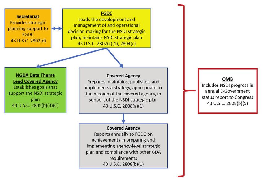
Figure 1. Overview of National Spatial Data Infrastructure (NSDI) planning in accordance with the Geospatial Data
Act of 2018 (GDA), showing the roles of the Federal Geographic Data Committee (FGDC), the FGDC covered agencies
and lead covered agencies, and the Office of Management and Budget. NGDA, National Geospatial Data Asset;
U.S.C., United States Code
12 | National Spatial Data Infrastructure Strategic Plan • 2021–2024 www.fgdc.govSummary of Expected Results
Initial Implementation Milestones
NSDI Strategic Plan and Agency Geospatial Strategy Implementation
Timeframe Activity
November 2020 NSDI strategic plan approved by the FGDC Steering Committee and endorsed by the NGAC
December 2020 FGDC covered agencies complete geospatial strategies required by the GDA (in support of the NSDI
strategic plan)
March 2021 NSDI implementation plan completed
December 2021 First annual status report submitted
Summary of Expected Results
A strategic plan is only effective if it has a strong implementation approach focused on achieving clearly defined outcomes.
An effective strategy should engage those whose mission will achieve the vision. The goals and objectives in this plan are
designed to mobilize the national geospatial community toward achieving the following results:
• Improved governance
Establishing a strategic plan reflects a commitment to clarify responsibilities and objectives for improved
effectiveness. This plan establishes a substantial foundation for solid governance that will balance needs with
resources and promote an open environment for discussion and decisions needed to achieve the described
objectives. Guidance from the FGDC in meeting Goal 1, when incorporated by FGDC agencies and documented
in their mandated reporting, will enable assessment of progress and identification of impediments.
• Expanded partnerships
Increasingly, the groups that generate and use geospatial data recognize that collaboration and data sharing with
trusted partners paves the way to achieving desired benefits. Sharing is often accompanied by expectations of
reliability that trusted partnerships facilitate.
• Sufficient resourcing
Resources include money, people, and time. Analysis of available and required resources is required to determine
appropriate levels of support. Thorough accountability across a carefully self-governed community, with prudent
oversight and guidance, will help focus attention on the existing distribution of resources, expose gaps for
prioritized geospatial data components, and suggest budgetary realignments to address funding, people, and time
shortfalls.
• Better integration of datasets
Data are not exclusively geospatial or location-based. Knowledge-building and decision making about things or
events that influence or are influenced by location require timely and relevant data and information from a variety
of sources. Although things do exist in specific places and events do occur at particular places and times, the data
about them often have no reason to be tagged or characterized as spatial. For years, practitioners have struggled
with the complexity of integrating different sources, quality, and formats of geospatial data but, increasingly,
with new tools and capabilities available, data integration occurs across disciplines. This strategic plan not
only addresses the need for geospatial standards and interoperability but recognizes the more complex task of
integration with other categories of data.
www.fgdc.gov National Spatial Data Infrastructure Strategic Plan • 2021–2024 | 13• Preparation of the workforce pipeline
People are part of the resource equation. Therefore, capacity building through education and training is needed
to ensure that the pipeline supplying the workforce is kept flowing. Although past practice may be a prelude to
some traditional earth-science training in specific domains, it must also be subject to the evolution of intersecting
disciplines. During the execution of this strategic plan, much more focus will be directed toward geospatial and
interdisciplinary information management. The skills demanded by the community may range from basic, such
as those required to collect and label data, to advanced, including the ability to incorporate machine learning and
artificial intelligence innovation into a broad spectrum of applications.
• Expanded markets
The past decade has seen the “democratization” of the collection and use of geospatial data. Many have joined
the ranks of “citizen scientists.” Computer-generated maps are used daily in all walks of life. Such maps have
helped urban planners decide where growth can be encouraged, have permitted first responders to ameliorate the
effects of natural disasters quickly, and have shown where ecological damage and (or) restoration is occurring.
The availability of massive reliable stores of geospatial data will continue to make expansion of services possible
and open new markets for these data.
• Innovation
As resources are expended to meet the known current needs of the NSDI and to satisfy the goals identified in this
plan, disruptive thinking, nurtured by the expansive use of geospatial information integrated within so much other
spatially ambiguous data, will also improve the way we understand Earth. Creativity applied to new challenges will
introduce innovation in tools and techniques that will not only improve the understanding of geospatial information
but will also direct its incorporation into new venues.
• International influence and cooperation
Both the vision and the mission of the NSDI link our national interests with our global responsibilities. The four
core themes of the goals in this plan—policy and governance, data assets, shared services and interoperability,
and partnerships—are guided by the Integrated Geospatial Information Framework (IGIF) that was adopted by
the UN-GGIM. The IGIF “provides a basis and guide for developing, integrating, strengthening and maximizing
geospatial information management and related resources in all countries. It will assist countries in bridging the
geospatial digital divide, secure socio-economic prosperity, and to leave no one behind” (United Nations Statistics
Division, 2020b).
References Cited
United Nations Statistics Division, 2020a, Committee of Experts on Global Geospatial Information Management: United
Nations Statistics Division web page, accessed October 6, 2020, at http://ggim.un.org/Mandates/.
United Nations Statistics Division, 2020b, Integrated Geospatial Information Framework (IGIF)—Overview: United Nations
Statistics Division web page, accessed October 6, 2020, at http://ggim.un.org/IGIF/.
14 | National Spatial Data Infrastructure Strategic Plan • 2021–2024 www.fgdc.govAppendix Appendix This appendix provides additional information about the organizations involved in the development of this strategic plan, the statutory authorities, and the abbreviations used. It also contains a section for acknowledgments. FGDC Member Agencies The Federal Geographic Data Committee (FGDC) is organized under the authority of the Geospatial Data Act of 2018 (GDA) and Office of Management and Budget (OMB) Circular A–16. The FGDC provides leadership for the National Spatial Data Infrastructure (NSDI) and coordinates the development, use, sharing, and dissemination of the Nation’s geospatial data. In accordance with the GDA, the FGDC is chaired by the Secretary of the Interior (or designee), and the OMB Director (or designee) serves as the vice chair. The FGDC includes the following member agencies: Federal Communications Commission* U.S. Department of Commerce General Services Administration U.S. Department of Defense Library of Congress U.S. Department of Education National Aeronautics and Space Administration U.S. Department of Energy National Archives and Records Administration U.S. Department of Health and Human Services National Capital Planning Commission* U.S. Department of Homeland Security National Science Foundation U.S. Department of Housing and Urban Development Office of Management and Budget U.S. Department of the Interior Office of Personnel Management U.S. Department of Justice Small Business Administration U.S. Department of Labor Smithsonian Institution U.S. Department of State Social Security Administration U.S. Department of Transportation Tennessee Valley Authority U.S. Department of the Treasury U.S. Agency for International Development U.S. Department of Veterans Affairs U.S. Army Corps of Engineers* U.S. Enviromental Protection Agency U.S. Department of Agriculture U.S. Nuclear Regulatory Commission ________ *Non-voting members National Geospatial Advisory Committee The National Geospatial Advisory Committee (NGAC) is a Federal Advisory Committee authorized through the GDA to provide advice and recommendations related to management of Federal and national geospatial programs, development of the NSDI, and implementation of the GDA. The Committee reviews and comments on geospatial policy and management issues and provides a forum to convey views representative of non-Federal stakeholders in the geospatial community. The NGAC includes representatives from all levels of government, the private sector, nonprofit organizations, and academia. Additional information about the NGAC, including a list of committee members, is available at www.fgdc.gov/ngac. www.fgdc.gov National Spatial Data Infrastructure Strategic Plan • 2021–2024 | 15
List of Authorities

         • Budget and Accounting Procedures Act of 1950, as amended (31 U.S.C. Chapter 11)

         • Chief Financial Officers Act (31 U.S.C. 3512 et seq.)

         • Clinger-Cohen Act of 1996 (also known as the “Information Technology Management Reform Act of 1996”)
           (40 U.S.C. 11101-11704)

         • E-Government Act of 2002 (44 U.S.C. Chapters 35 and 36)

         • Electronic Signatures in Global and National Commerce Act (E-Sign) (15 U.S.C. Chapter 96)

         • Executive Order 13719, Establishment of the Federal Privacy Council (2016)

         • Federal Data Strategy (strategy.data.gov)

         • Federal Information Security Modernization Act of 2014 (44 U.S.C. Chapter 35, Subchapter II)

         • Federal Information Technology Acquisition Reform Act (FITARA) (Pub. L. 113–291)

         • Foundations for Evidence-Based Policymaking Act of 2018 (or OPEN Government Data Act, Pub.L. 115–435)

         • Geospatial Data Act of 2018 (43 U.S.C. Chapter 46)

         • Government Paperwork Elimination Act of 1998 (44 U.S.C. 3504)

         • Government Performance and Results Act (GPRA) of 1993, as amended by the Government Performance and
           Results Modernization Act (GPRA Modernization Act) of 2010 (5 U.S.C. 306 and 31 U.S.C. 1115 et seq.)

         • Office of Federal Procurement Policy Act (41 U.S.C. Chapter 7)

         • Office of Management and Budget, 2000, November 28, Circular A–130 Revised

         • Office of Management and Budget, 2002, August 19, Circular A–16 Revised

         • Office of Management and Budget, 2006, March 3, Memorandum M–06–07: Designation of a Senior Agency
           Official for Geospatial Information

         • Office of Management and Budget, 2010, November 10, Circular A–16 Supplemental Guidance

         • Paperwork Reduction Act (PRA) of 1980, as amended by the Paperwork Reduction Act of 1995
           (44 U.S.C. Chapter 35)

         • Privacy Act of 1974, as amended (5 U.S.C. 552a); Digital Accountability and Transparency Act of 2014
           (Pub. L. 113–101)

         • The White House, 1994, April 11, Executive Order 12906: Coordinating Geographic Data Acquisition and Access:
           The National Spatial Data Infrastructure

16   |   National Spatial Data Infrastructure Strategic Plan • 2021–2024                                    www.fgdc.gov
Appendix Abbreviations FGDC Federal Geographic Data Committee GDA Geospatial Data Act of 2018 IGIF Integrated Geospatial Information Framework NGAC National Geospatial Advisory Committee NGDA National Geospatial Data Asset NSDI National Spatial Data Infrastructure OMB Office of Management and Budget UN–GGIM United Nations—Global Geospatial Information Management Acknowledgments This plan was developed by an interagency team from the Federal Geographic Data Committee, and significant inputs were provided by the National Geospatial Advisory Committee. The following organizations participated in “NSDI Leaders Forum” listening sessions in 2020 and provided inputs and (or) comments that helped inform the development of the plan: American Society of Photogrammetry and Remote Sensing American Association of Geographers AmericaView Cartography and Geographic Information Society Coalition of Geospatial Organizations GIS Certification Institute International Association of Assessing Officers International Cartographic Association National Society of Professional Surveyors National States Geographic Information Council Open Geospatial Consortium University Consortium for Geographic Information Science Urban and Regional Information Systems Association U.S. Geospatial Intelligence Foundation www.fgdc.gov National Spatial Data Infrastructure Strategic Plan • 2021–2024 | 17
You can also read