Boston Bike Network Plan - Boston.gov
←
→
Page content transcription
If your browser does not render page correctly, please read the page content below
Boston
Bike
Network
Plan
Boston Department
 of Transportation
Boston Department
of Transportation
In Collaboration with:
Members of the Citizens Working Group
City of Boston
Mayor’s Office
Boston Redevelopment Authority
Boston Police Department
Boston Transportation Department
Bostonians
Department of Information and Technology
Boston Public Health Commission
Boston Emergency Medical Services
Department of Innovation & Technology
Environment and Energy Services
Mayor’s Office of Neighborhood Services
young &
Office of Budget Management
Parks and Recreation Department
Public Works Department
Commonwealth of Massachusetts
Department of Conservation and Recreation
old, get
Massachusetts Bay Transportation Authority
Massachusetts Department of Transportation
Massachusetts Port Authority
Metropolitan Area Planning Council
out and
Town of Brookline
City of Cambridge
City of Newton
City of Somerville
ride ...
Transportation Department Key Staff
Commissioner Thomas Tinlin
Vineet Gupta, BTD
Boston Bikes
— Alice Brown, Program Manager
— Kris Carter, Interim Director
— Nicole Freedman, Director
Toole Design Group:
— Michelle Danila, Engineer
— Nick Jackson, Director
— Laurie Pessah, Project Manager
— Pete Robie, GIS Manager
2
Three years ago I declared “The car is no longer king in
Boston” and since then Bostonians have taken more than one
million rides on New Balance Hubway and nearly doubled
their daily ridership to work. I’m proud of the 65 miles of bike
facilities we have installed in the last three years and of our
Silver Bicycle Friendly Community designation.

This Bike Network Plan will improve the quality of life for
every Bostonian and help keep Boston strong by improving
our health, our air quality, and reducing congestion on our
city streets.

I know that this Bike Network Plan will help to transform
Boston into a world-class bicycling city and make it possible
for every Bostonian, young and old, to get out and ride.

                                   —Mayor Thomas M. Menino

                                                                   3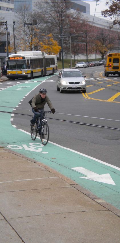
Boston Bike Network Plan

    OVERVIEW

    Vision
    By every measure, bicycle use in Boston is growing
    rapidly. Biking to work soared by 82 percent between
    2008 and 2011, and other surveys show double-digit
    increases in all types of bicycling each year. The New
    Balance Hubway system is making it easy for almost
    anyone to get on a bicycle.
    The City of Boston is committed to helping more
    residents and visitors to get on bikes and to making
    it safer to ride. Encouraging more bicycle trips is an
    important component of the City’s Climate Action
    Plan, which sets a 2020 target of increasing the
    share of commute trips by bike to 10 percent. The
    2013 Cyclist Safety Report sets a goal of decreasing
    bicycle crashes by 50 percent in the same timeframe.
    The Boston Bike Network plan is intended to support
    the growing number of bicyclists and help the city
    reach its sustainability and safety goals.
    The Boston Bike Network Plan:
      •   Was developed with the input of city
          departments, state agencies, and hundreds of
          citizens who spoke up at open houses, made
          suggestions through an online mapping tool, or
          served on a Citizens Working Group.
      •   Lays out a plan for creating safer streets for
          bicycling that will attract and support new riders
          while improving the safety and comfort of all
          bicyclists.
      •   Identifies a comprehensive network of bicycle
          routes through the city, calling for 75 miles of
          new facilities in the next five years and reaching
          a network of 356 miles within 30 years.
      •   Will be used by city departments, state
          agencies, and developers so that as they
          modify city streets they are helping to create a
          world-class bicycling city.

2
Boston Bikes Initiative and the City’s
Sustainability Commitment
Boston Bikes is Mayor Menino’s citywide program
to encourage citizens and visitors to use bicycles
for fun, exercise, and transportation. Since 2007,
Boston Bikes has laid down 65 miles of bicycle
facilities, launched the Hubway bikeshare,
distributed over two thousand bikes through Roll
It Forward, sponsored education through its Youth
Cycling Program, and engaged in many other
activities to promote bicycling in Boston. The
Boston Bike Network Plan will help Boston Bikes
broaden its reach by setting out an ambitious
vision for a safe and inviting bicycle network that
can then guide the work of all city departments,
state agencies, and the public as they improve
bicycle infrastructure in Boston.
Boston Bikes’ efforts are just one part of the City’s
commitment to reduce transportation-related
greenhouse gas emissions 28 percent. Boston’s
new Complete Streets guidelines also provide
general standards for how to routinely build safer,
smarter multi-modal streets that serve people
walking, bicycling, driving, and taking public
transportation.
The Boston Bike Network Plan prioritizes bicycle
treatments on a network of primary and secondary
streets so that people who choose to bike will
be able to safely reach every corner of the City.
The heart of the plan is a Geographic Information
System database, a sophisticated map with many
layers of information that will be integrated with
other city maps so that every agency that touches
the streets can help with implementation. This
will make for a collaborative and cost-effective
approach to creating this network over the next
few decades.

Year               2008 2013        2018      2043
Network Miles      55      120      195       356

                                                        3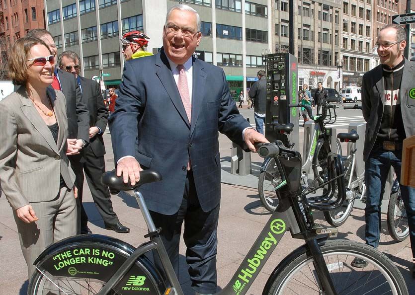
Boston Bike Network Plan
30-YEAR VISION
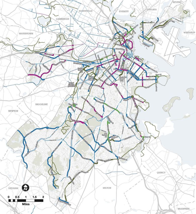
The Boston Bike Network Plan proposes a Primary Routes
seamless network of on and off-street routes Primary routes connect neighborhood centers,
linking destinations from one end of Boston to regional multi-use paths, transit hubs, major
the other. Two key principles were identified employment centers, and institutional destinations.
during the public process and these guided the
development of the Boston Bike Network Plan. Primary routes:
• Are the “spine” of the network and provide
long distance routes across the city.
The network must provide:
1. Direct connectivity to destinations such
• Carry the highest volumes of bicyclists.
as workplaces, schools, parks, and public • Have as much separation from traffic as
transportation possible in order to provide a comfortable,
low-stress experience that will welcome
2. Comfortable and safe bicycle paths, lanes, riders of all ages and abilities.
and shared streets that appeal to new and
existing riders • Utilize the existing paths along the City’s
linear parks and waterways.
Connectivity is an obvious criteria if residents • Include all major bridges connecting
neighborhoods and adjoining municipalities.
are to use bicycles to reach destinations, instead
of just for recreation. Dedicated space on the Secondary Routes
roadway encourages more riding – the 65 miles
of bike lanes added to the city streets since 2007 Secondary routes stretch into neighborhoods
have already helped spur the increase in bicycle and provide access to local businesses and
use. Recent research has confirmed that comfort neighborhood destinations.
and safety are essential in attracting new riders Secondary Routes:
to using bicycles, and that means increasing the • Connect to schools, neighborhood stores,
separation between bicycles and cars. parks, transit hubs, and primary network
A new generation of bicycle facilities provides routes.
greater comfort and safety for people of all ages • Carry varying volumes of bicyclists
and riding abilities, and this plan draws on all of depending on the population density and
them. The Boston Bike Network Plan envisions destination.
a network of routes that will include high quality • Have varying levels of separation from traffic
separated cycle tracks, and ‘neighborways’ that depending upon the context and character
prioritize bicycle travel along quiet residential of the street.
streets. Traditional bike lanes, shared streets, and
wayfinding are also important parts of the network.
• Are mainly comprised of bike lanes, contra-
flow lanes, and priority shared lanes.
In each neighborhood, the buildout of the network
will be shaped by the context of individual
projects, community input, and the goals of this
plan. A network of this size and scope will require
many years of coordination and commitment. The
network will be constructed incrementally as the
city rebuilds and constructs new infrastructure.
Some recommendations are tied to the
reconstruction of major roads which generally
occur on a 20-30 year cycle.
4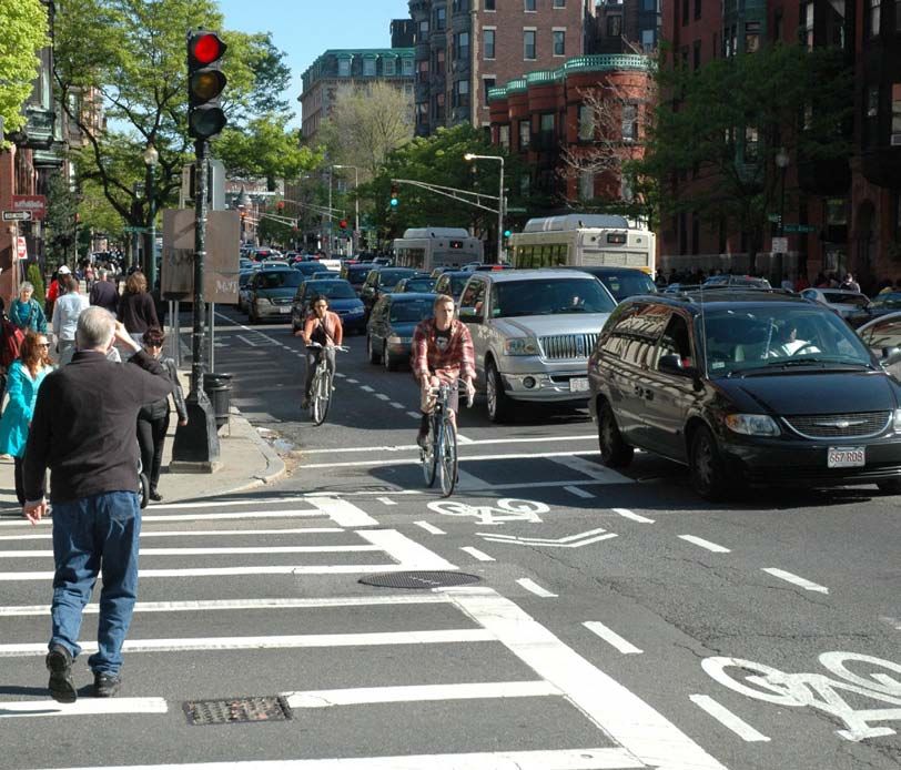
30-Year Vision

Route       Miles
Primary     108
Route
Secondary   248
Route

                                                        FACILITY           APPROXIMATE
                                      MILEAGE SUMMARY

                                                        TYPE                   MILEAGE
                                                         Off-Street Path        108
                                                         Protected Lane          59
                                                         Exclusive Lane         116
                                                         Shared Lane             38
                    Primary Route                        Shared Road             35
                    Secondary Route                      Total                  356

                                                                                   5
Boston Bike Network Plan

INFRASTRUCTURE TOOLKIT
    The following facility types are drawn from the        Shared Lanes
    Boston Complete Streets Guidelines, the National
    Association of City Transportation Officials
                                                           Bus-Bicycle Lane
    (NACTO) Urban Bikeway Design Guide, and                Shared on-road facility designated only for bus
    the American Association of State Highway and          and bicycle use.
    Transportation Officials (AASHTO) Guide for the
    Development of Bicycle Facilities.
                                                           Shared Lane
                                                           Shared bicycle and motor vehicle travel lanes
                                                           denoted using pavement markings (commonly
                                                           referred to as “sharrows”) and signs. Used in
    Off-Road Path                                          constrained corridors where the speed limit is no
                                                           more than 35 MPH.
    Shared Use Path
    Off-road pathway physically separated from traffic
                                                           Advisory Lanes
    and designated for shared use or with an               Roadway with dashed bike lanes on both sides
    adjacent separated paths for bicyclists and            and no center line. Motor vehicles share the
    pedestrians.                                           middle of the street and are permitted to enter the
                                                           bike lane to give way to oncoming motor vehicles.

    Protected Bicycle Lane                                 Priority Shared Lane
    Cycle Track                                            Shared lane with additional visual cues to denote
                                                           bicycle priority and encourages motor vehicles to
    Exclusive bicycle facility separated from motor        pass bicycles by switching lanes.
    vehicle lanes and sidewalks by fixed objects such
    as parked cars, curbing, bollards or flexposts.
                                                           Shared Roads
    Excusive Lanes                                         Shared Street
                                                           Street with very slow speeds that allow all modes
    Bicycle Lane                                           of travel to share one space (sidewalks are often
    On-road bicycle facility designated for exclusive      blended with the roadway).
    use by bicyclists through pavement markings and
    signs.                                                 Recommended Local Route
                                                           Unimproved quiet residential street that provides
    Buffered Bicycle Lane                                  connectivity to neighborhood destinations and
    Bicycle lane with an additional painted buffer to      primary routes.
    provide more separation from motor vehicles.
                                                           Neighborway
    Contraflow Bicycle Lane                                Also known as a bicycle boulevard, a neighborway
    Bicycle lanes installed on a one-way street that       is a quiet, low-volume residential street with added
    allow bicyclists to travel in both directions while    traffic calming. This type of slow street gives
    vehicular traffic remains one-way only.                priority to bicyclists and pedestrians.

    Climbing Bike Lane
    Bicycle lane in the uphill direction and shared lane
    markings in the downhill direction. Used on hills
    where there is insufficient space for a bike lane in
    both directions.

6
FIVE TYPES OF BICYCLE FACILITIES

                                                    marked
                                                    shared
                                                     lane

                           marked
                           shared
                            lane

Examples of New Types
of Bicycle Facilties

                                                              marked
                                                              shared
                                                               lane

Two Way            Contraflow       Advisory Lane   Neighborway
Cycle Track        Bike Lane

                                                                       7
Boston Bike Network Plan

    INTERSECTIONS

    The following infrastructure tools can be used to
    improve bicycling in Boston. These designs can
    improve safety and efficiency at intersections,
    tailor wayfinding to bicycles, and modify the built
    environment to increase access for bicyclists.

    Bike Boxes
    Bike boxes provide a dedicated space between
    the crosswalk and stop line to wait during
    the red light at signalized intersections. Bike
    boxes allow bicyclists to wait ahead of traffic
    to be more visible and aid in making turning
    movements.

    Two-Stage Left Queue Boxes
    A two-stage left queue box provides a place for
    bicyclists to turn without merging across lanes
    by staying to the right of the initial lane and then
    stopping at the far side of the intersection on the
    right hand side of the perpendicular lane to wait
    for the subsequent light.

    Bicycle Markings through
    Intersections
    Dashed lines and/or green paint alert motorists
    and bicyclists to potential conflicts and indicate
    that turning vehicles should give precedence to
    bicyclists going straight just as they would yield
    to pedestrians in a parallel crosswalk.

    Bicycle Friendly Traffic Calming
    Traffic calming measures should be designed
    to accommodate bicyclists. Particularly along
    neighborways, traffic calming is strongly
    encouraged by the Boston Bike Network Plan
    and the Boston Complete Streets Guidelines.
    Examples of traffic calming treatments include
    curb extensions, speed tables, chicanes,
    stormwater plantings, cut-throughs, and
    diverters.

8
Bicycle Signals
Bicycle-specific signal heads use a bicycle symbol
lens at signalized intersections to indicate when
bicycles may travel through the intersection.
Similar to a pedestrian walk signal, bicycle signals
can help minimize conflicts between bicyclists and
other modes of transportation.
Signal Detection
In the Commonwealth of Massachusetts,
design standards require that additional loop
detectors and pavement markings be installed
at signalized intersections to indicate where
bicyclists should wait in order to be detected by
the sensor. Consideration should be given to new
technologies in detection for bicyclists, such as
infrared and video detection.
Signal Timing
Along streets within the network, changes to signal
timing should take into account minimum green
times and clearance times for bicyclists to safely
cross an intersection. Signal progression should
also consider bicyclist speeds (typically 12 mph).
Spot Improvements
Small scale improvements help to eliminate
hazards and obstacles for cyclists.
• Non-skid steel plates for construction
zones
• Bicycle friendly drainage grates
• Stair rails
• Perpendicular trolley track treatments
• Surface treatment on operable bridges
Wayfinding
Boston will continue to work with other agencies
and municipalities to coordinate regional
wayfinding and signage.
Wayfinding will help guide people to key
destinations such as:
• Primary routes
• Transit stations
• Neighborhood centers and squares
• Parks and institutions
• Other major destinations
9Boston Bike Network Plan
ABOUT THE BIKE NETWORK PLAN
How was the plan developed?
Boston Bike Network Plan Process
The Boston Bike Network Plan was developed
over three years and included an extensive
consultation process with citizens, City staff, and
specific stakeholder groups. Boston Bikes staff
also reviewed existing plans, conducted site visits,
and collected data.
All of these sources helped determine which
routes to include in the proposed network. Facility
type recommendations were developed by
taking into account the existing conditions and
characteristics of each individual route and its role
within the overall network.
Outreach and Coordination Data Sources
Groups involved in outreach and coordination Data sources used to create the plan included:
included: • The MassDOT road inventory, which
• Residents, through public open houses and provides information on road classification,
an online mapping tool that gathered initial and formed the basis of the GIS database.
input on the draft network.
• In-person observation of every street in
• A citizens working group made up of the network to collect details such as
representatives from neighborhood width, parking, bus routes, speed limit, and
organizations, local advocacy groups, neighborhood context.
universities, and business associations.
• Relevant local and regional transportation,
• An interdepartmental committee of land-use and neighborhood plans and
individuals from eight City departments. roadway designs from agencies including
MassDOT, the Department of Conservation
• Key City departments such as the and Recreation, the Boston Redevelopment
Public Works Department, the Boston Authority, the Public Works Department, and
Redevelopment Authority, and the Parks and the Boston Transportation Department.
Recreation Department.
• Neighboring communities and state
agencies.
Outreach and coordination will continue during
the implementation phase of the plan through a
standing committee of representatives of critical
City departments and ongoing citizen input.
10IMPLEMENTATION
How will the plan be realized?
Implementation critical but more comprehensive infrastructure
The vision for implementing the Boston projects are infeasible or not warranted. Funding
Bike Network Plan is two-fold. First, bicycle for these project could come from the Boston
infrastructure will be incorporated into existing Transportation Department’s Capital Improvement
transportation and infrastructure projects to Plan in addition to other local and state sources.
the greatest extent possible. The design, public Design and Review Process
review, funding and construction of the majority of
bicycle infrastructure miles will be implemented As a segment is scheduled for implementation
as a component of other projects, according it will go through a complete design and review
to the funding and review procedures of each process. This may include traffic analysis, parking
department or agency managing the project. utilization studies, neighborhood planning, and
Working within existing projects is cost effective, community outreach.
promotes complete streets, and is the most The steps of the design and review process will
efficient use of design resources and public depend on the procedures of the project lead
process. Secondly, Boston Bikes will initiate key — whether a City of Boston department, state
projects that fall outside of work planned by other agency, developer, or other organization.
departments and agencies. Ideally, the bicycle facility will be considered at the
The City of Boston, MassDOT, Massport, beginning of the design and public review process
Department of Conservation and Recreation, so that it is developed in the context of the entire
private institutions, and developers will all street or project.
participate in the buildout of the network.
Repair, reconstruction, bridge projects, real Neighborhood Studies
estate development, and capital projects are Between the citywide Bike Network planning and
all opportunities to implement segments of the implementation stages, some neighborhoods
network, using the existing resources for road or districts may require further analysis and
repair and infrastructure projects. Boston Bikes neighborhood input on routes and coordinating
staff will continue to provide technical assistance, transportation improvements with transit, parking,
research, traffic analysis, peer review, and or open space planning.
outreach as needed for these projects.
A smaller portion of the bicycle infrastructure
miles will be completed as independent projects,
designed, funded, and developed as bicycle-
exclusive improvements. These will mainly be
retrofit projects where bicycle improvements are
Planning Implementation
complete!
Boston Bike 5-Year
Community Design and
Network Action Plan
(annually updated) Process Construction
Plan
neighborhood planning
if applicable
11Boston Bike Network Plan
Inputs and outputs
Gradual Growth Outputs
Boston Bikes’ strategy for funding and Reaching the City’s goal of 10 percent of trips by
implementing this 30-year vision is incremental. bicycle will have a positive effect on Bostonians’
The bike network will be steadily expanded over every day lives across a range of areas from the
the next 30 years. Each year, multiple agencies economy to public health.
and departments and other actors will dedicate • New jobs
funds to construct a portion of the network. These In 2012, two international bike leaders
various actors will draw from many sources opened offices in Boston and six other
including budgets from annual repair and small bicycle related businesses were
maintenance, discrete capital projects, federally launched. Between 2007 and 2012, local
funded projects, and private investment. businesses added 650 new jobs related to
the bicycle industry.
The Boston Bike Network Plan includes a cost
calculator for planning purposes. The calculator • Retail success in proximity to bicycle
estimates the construction cost of each type of facilities
Research in Boston, Minneapolis, and
bicycle facility either as an addition to an existing
Washington D.C. has documented
project or as a stand-alone infrastructure project. increased sales for local businesses
Implementation budgeting must take into adjacent to bikeshare stations. In New
consideration more than just construction York, sales receipts increased by 50
costs. While bicycle infrastructure construction percent along 8th and 9th Avenues
cost is relatively low compared to other types following the installation of cycle tracks on
these streets.
of construction, design, review, and project
management time can be comparable to other • Increased property values
types of infrastructure projects. For these reasons, A 2008 study estimated a $5,500 greater
wrapping bicycle infrastructure into other projects sales price for homes located along
is the most cost effective and practical approach bicycle boulevards (or neighborways).
Commercial rents along new bicycle
to implementing the Bike Network.
infrastructure in New York jumped 71
Maintenance percent in one year.
Boston Bikes will coordinate with the Boston • Reduction in health care costs
Transportation Department, Public Works International studies have shown that
every $1.50 spent on bicycling that
Department, and other partners to manage routine
increased physical activity can result
maintenance of bicycle facilities including: in over $6.00 in savings in health care
• Snow plowing expenditures.
• Street sweeping • Congestion relief
More trips by bicycle will relieve
• Pothole repair and grate resetting
congestion on city streets and transit
• Flexpost installation or removal systems. This can have a big impact
on reducing neighborhood traffic and
• Signage replacement overcrowding on the T.
• Pavement markings restriping • Reduction in facility maintenance
(approximately every 5 years) Bicycles trips cause less wear and tear on
Boston Bikes has a budget in the City’s operating infrastructure than motor vehicles.
and capital plan to support a portion of design,
implementation, and maintenance.
12How do we use the plan?
Plan Products
The Boston Bike Network Plan will be a reference
for city builders, citizens, and planners.
The Boston Bike Network map and
recommendations will be conveniently accessible
to the public and government staff via an online
interactive mapping tool and published maps.
The Boston Bike Network Plan is built in GIS
(Geographic Information System) and includes a
database with information about every segment
in the network. This database can be shared and
queried to create maps and analysis at any scale.
The GIS data will be publicly available through
Data for Citizens, Government,
the City’s DataHub. At least semi-annually, Boston
Bikes will update the data with any changes to and Technical Users
status or recommendations.
Maps of the network will be published on the City The Public:
of Boston’s website and available for download. Citizens, consultants, advocates and others will be
Published maps will include: able to consult the published and online mapping
tool to find out about what streets and paths are
• A citywide map designating Primary and
part of the Boston Bike Network, what type of
Secondary Routes in the 30-Year Plan.
facilities are proposed, and when they may be
• A citywide map of the facilities planned for installed.
installation during the current 5-Year Action
Plan. Staff:
• A jurisdiction map denoting which agencies/ Project managers, planners, neighborhood
entities manage/operate transportation liaisons, and other staff of the City of Boston and
facilities such as roadways, paths, and state agencies will be able to reference the Boston
transit hubs. Bike Network Plan to coordinate installation with
their own projects. The Boston Bike Network data
• Neighborhood scale maps that include
will be compatible with the systems that track
existing facilities and details.
Boston Redevelopment Authority development
The online maps will allow users to click on a review, road and utility work, and other types of
segment to see detailed information about the mapped project management tools so that the
proposed facility such as parking and operations, bike recommendations appear alongside on-
the recommended bike facility, the jurisdiction and going projects of all types. Printed maps can be
the status. customized by geographic area of interest, type
of project, project lead, demographics or statistics
relevant to their work.
GIS Users:
The geodatabase will be published on the City’s
DataHub for download and regularly updated.
Data managers for other agencies, municipalities,
application developers, or consultants will be able
access the latest data to make their own maps or
integrate with proprietary data.
13Boston Bike Network Plan
5-Year Action Plan
Opportunities 5-Year Implementation and Budget
Each year, Boston Bikes will work with City of The Boston Bike Network Plan includes a cost
Boston departments, MassDOT, Department calculator that estimates the construction
of Conservation and Recreation, and private cost of each bicycle improvement based on
developers and institutions to anticipate, the recommended facility type, length, and
prioritize, and coordinate projects that present an means of implementation. Other variables for
opportunity to implement segments of the Boston understanding the distribution of implementation
Bike Network Plan. These network segments will costs are jurisdiction and whether the proposed
be collected in a 5-Year Action Plan that shows bicycle improvement is associated with an existing
work “on the drawing boards.” infrastructure or development project.
Priorities for the next 5 years PART OF EXISTING PLANS
The City plans to complete 75 miles of the
Bike Network. These segments were selected • Includes approximately
50% of
$5 million dollars’ worth of
according the following criteria: estimated
opportunities for public-private
• Improvements planned along roads slated construction
partnership
for other design projects or scheduled costs
before 2019 • Bicycle infrastructure is already
18% of mileage a component of the design in
• Improvements that address the greatest (19 miles) most cases
needs in the network as determined by
• Includes Connect Historic
existing bicycle volume counts and crash
Boston TIGER Grant projects
data
RETROFIT (NO RECONSTRUCTION)
• Segments that establish long distance
connections between neighborhoods
25% of • Can be installed as part of
• Segments closing gaps and completing estimated annual resurfacing, restriping,
partial segments in the existing network, construction and regular maintenance
along primary routes costs
• Cost estimate accounts for the
• Segments that help ensure equitable
72% of mileage expense of adding pavement
distribution of bicycle facilities to all markings, flexposts, and bicycle
(75 miles)
neighborhoods within Boston signage
RECONSTRUCTION
Cycle Tracks
25% of • Will be initiated by Boston Bikes
The 5-Year Action Plan includes 21 miles of cycle
estimated • Includes most cycle tracks listed
tracks. Of these, the highest priority cycle track
construction in the opposite column
projects are: costs
• Arlington, Boylston, South Charles, and • Requires reconstruction
Beacon Streets around the Public Garden 10% of mileage in locations where it is not
(11 miles) otherwise planned
• Boylston Street, Back Bay
• Malcolm X Boulevard, Roxbury
In total, the cost estimate for the 100 miles
• Massachusetts Avenue (Melnea Cass identified in the 5-Year Action Plan is
Boulevard to Columbia Road), Roxbury approximately $30 Million dollars in construction
• Mt. Vernon Street, South Boston expense. Actual costs of implementation will
vary depending on how and by whom segments
• Summer Street, South Boston
are completed. The implementation of the 5-Year
• Tremont Street, Downtown Action Plan requires the continued coordination
and cooperation among all jurisdictions: the City
of Boston, MassDOT, Department of Conservation
and Recreation, Massport, MBTA, the National
Park Service, private institutions, and landowners.
145-Year Action Plan
As projects are always subject to delay or modification, Boston Bikes anticipates that approximately 75 percent of the
segments identified for the 5-Year Action Plan will be accomplished during that timeframe for a total of approximately 75
completed miles. Note: Map includes 105 miles to compensate for this factor.
FACILITY APPROXIMATE
MILEAGE SUMMARY
TYPE MILEAGE
Off-Street Path 14
Protected Lane 21
Exclusive Lane 47
PROPOSED
Off-Street Path
EXISTING
Protected Lane
Shared Lane 16
Exclusive Lane
Shared Lane Shared Road 7
Shared Road
Total 105
15Boston Bike Network Plan
THE LONG VIEW
Transportation Trends Healthy Corridors
Boston streets, sidewalks, and paths will look In order to achieve 10 percent or higher bicycle
very different from today as the City moves modeshare, broad, continuous, long distance
toward achieving its Climate Action Plan goals routes will be an essential part of the Boston Bike
and as residents and visitors have more choices Network. These Healthy Corridors, also known
in how to travel. Some of the more ambitious as Green Links, are the next phase of bicycle
recommendations of this plan will be implemented infrastructure. Similar projects are already being
closer to the 2043 date, aligned with anticipated implemented in Europe and some US cities.
changes in local conditions and demand. Major
Several long-standing, multi-use paths are
changes anticipated that the Boston Bike Network
candidates for upgrades into major, continuous
Plan will adapt to include:
routes. These corridors may need to be upgraded
• Changes to modeshare and public support and reconstructed to accommodate higher
for bicyling volumes of all types of active transportation and
Recent trends show car ownership and
recreation including biking, walking, running,
vehicle miles traveled are on the decline
in Boston. Some recommendations in the
rollerblading, etc. Master planning efforts for
Boston Bike Network Plan that require travel segments and the entire system are underway or
lane reductions and or parking consolidation will be undertaken in the coming years.
may not be practical in 2013; however, the
Boston Bike Network Plan anticipates that
these operational changes will be possible Potential Healthy Corridors include:
in the future.
• Transit expansion
• The Charles River Basin Paths
Some bike network infrastructure demand • The Southwest Corridor
will be closely tied to transit infrastructure
and capacity; this includes bus rapid transit
• The Neponset River Greenway
projects and Hubway expansion as a • The Rutherford Avenue Paths
component of public transit.
• The South Bay Harbor Trail
• Growing demand exceeding network
capacity • Commonwealth Avenue
Demand for existing sidewalk and bicycle (Allston-Brighton)
infrastructure and projects implemented in
the next five years may exceed capacity as
modeshare increasingly shifts to walking,
biking, and transit. Recommendations in
the Boston Bike Network Plan should be
reviewed every two years to adjust for
changing transportation patterns.
16Cambridge Cambridge
Brookline Brookline
2008 55 miles 2013 120 miles
Cambridge Cambridge
Brookline Brookline
2018 195 miles 2043 356 miles
17Boston Bike Network Plan
Fall 2013
2You can also read