National Spatial Data Infrastructure vs Cadastre System for Economic Development: Evidence from Pakistan
←
→
Page content transcription
If your browser does not render page correctly, please read the page content below
land
Article
National Spatial Data Infrastructure vs Cadastre System for
Economic Development: Evidence from Pakistan
Asmat Ali             and Muhammad Imran *

                                          Institute of Geo-Information & Earth Observation, PMAS-ARID Agriculture University,
                                          Rawalpindi 46000, Pakistan; ali00490@alumni.itc.nl
                                          * Correspondence: imran.igeo@uaar.edu.pk

                                          Abstract: The growth of Pakistan’s agriculture-based economy depends on elevating agriculture
                                          production and raising the per-capita income of rural communities. This paper evaluates the value
                                          of two simultaneous initiatives for the economic development of Pakistan, i.e., (i) reforming and
                                          modernization of the cadastre system, and (ii) the implementation of national spatial data infrastruc-
                                          ture (NSDI). Both can provide crucial frameworks to assemble geographic information necessary for
                                          effective agriculture policies in the country. Their execution at the national level requires substantial
                                          technical, human, and finical resources. These mega initiatives may become highly challenging,
                                          due to the already shrinking economy of the country from COVID-19. The study makes use of an
                                          evaluation framework, official documents, such as project proposals, minutes of meetings, in addition
                                          to data collected through questionnaire and from ministries, such as the ministry of planning, de-
                                          velopment, and reforms (commonly known as planning commission), as well as Pakistan bureau of
                                          statistics. Our findings indicate that both the projects share some commonalities in terms of benefits,
                                          problems, and resources. However, the economic benefits of the NSDI project are high compared to
                                the cadastre for the country, especially for effective agricultural policy-making. The results output

                                          will help practitioners from both systems to reduce the overlapping value, cost, and scope of the
Citation: Ali, A.; Imran, M. National
                                          work involved.
Spatial Data Infrastructure vs
Cadastre System for Economic
                                          Keywords: land; NSDI; cadastre; economic development; agricultural policy-making
Development: Evidence from
Pakistan. Land 2021, 10, 188. https://
doi.org/10.3390/land10020188

Academic Editor: Rohan Bennett            1. Introduction
                                               Spatial data (also referred to as geospatial, geographic, or location-based data) relate
Received: 14 January 2021                 objects to a location on the Earth [1]. Geospatial information has substantial value for
Accepted: 10 February 2021                the economy and society [2,3]. Land can generate income, and therefore, is “also a key
Published: 13 February 2021               economic resource inextricably linked to access to, use of and control over other economic
                                          and productive resources” [4]. Integrated geospatial frameworks, such as cadastre and
Publisher’s Note: MDPI stays neutral      national spatial data infrastructure (NSDI), improve efficiency (e.g., time and cost savings)
with regard to jurisdictional claims in   and effectivity of geographic information about the land for economic development. The
published maps and institutional affil-   agriculture sector in Pakistan contributes almost 23.4% to its GDP, is directly associated
iations.
                                          with 70% of rural livelihood, and engages 45% of the national workforce [5]. For such
                                          an agriculture-based economy, efficient and effective geospatial information is necessary
                                          for evidence-based policy-making to increase agricultural production and the national
                                          GDP. For instance, with the Infrastructure for Spatial Information in Europe (INSPIRE)
Copyright: © 2021 by the authors.         framework, the Ministry of Agriculture of the Republic of Lithuania saved 20,000 work-
Licensee MDPI, Basel, Switzerland.        ing days gaining 1.2 million Euro indirect socio-economic benefits and 1.8 million Euro
This article is an open access article    direct saving [6].
distributed under the terms and                A cadastre is an up-to-date land information system (LIS) containing a parcel-based
conditions of the Creative Commons
                                          record of land interests (e.g., rights, restrictions, and responsibilities). It usually includes
Attribution (CC BY) license (https://
                                          the geometric description of a land parcel linked to other thematic attributes regarding
creativecommons.org/licenses/by/
                                          the ownership or control of the parcel interests and its value and improvements. It may
4.0/).

Land 2021, 10, 188. https://doi.org/10.3390/land10020188                                                      https://www.mdpi.com/journal/land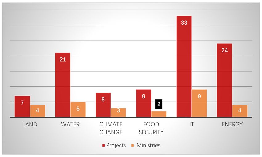
Land 2021, 10, 188                                                                                             2 of 17

                     establish fiscal (e.g., valuation and equitable taxation) and legal purposes (conveyancing)
                     to assisting the management of land and land use (e.g., for planning and other adminis-
                     trative purposes) and to enabling sustainable economic development or environmental
                     protection [7]. Williamson [8] argues the LIS developed with accurate land cadastre and
                     integrated with GIS technology is the fundamental infrastructure for economic develop-
                     ment. It is well established that a well-organized and standardized LIS promotes trust for
                     public investments and wealth accumulation, a crucial ingredient for digital business and
                     sustainable economic development. On the other hand, an NSDI initiative is generally
                     concerned with policy, technology, (technical) standards, people (including partnerships),
                     and geospatial data [1]. The possible benefits of implementing the NSDI could refer to
                     costs and time savings (efficiency gains), more effective policy-making, collaboration im-
                     provement, workflow modernization, economic development [3], better service delivery,
                     and production of new products and services for a wide range of stakeholders. Masser [9]
                     and Williamson [10] discussed three common objectives of most NSDIs about promoting
                     economic development, stimulating better government, and fostering environmental sus-
                     tainability. Geospatial information is widely considered one of the crucial parameters for
                     any economic development model [11]. However, without NSDIs implementation, it is
                     impossible to harvest full socio-economic benefits of geospatial data for national to regional
                     development [12,13].
                          As compared to most developed countries, however, Pakistan is quite late in recogniz-
                     ing the economic potential of land-related geospatial data and their contribution towards
                     the agriculture sector. Because the geographic information systems were relatively new to
                     the policy-makers, who historically underestimated the socio-economic value of systematic
                     acquiring, maintaining, and disseminating geospatial data [14]. Therefore, there had been a
                     lack of political will to regard geospatial information as a national asset [15]. Consequently,
                     the development of policies regarding institutional and legal issues of geospatial data
                     always gets the least priority at higher levels [14]. However, recently Government of
                     Pakistan (GoP) has made available a large number of public funds for 631 projects relevant
                     to land and spatial data in the country during the fiscal year 2020-21.
                          The objective of the present study is to evaluate the simultaneous developments of
                     two projects: (i) Reforming and modernization of the cadastre system and (ii) establishment
                     of NSDI in Pakistan, to set pivotal organizational characteristics (in terms of type, size,
                     level, roles, and resources), usage, demands/needs, motivations, and relationships with
                     other stakeholders. To accomplish this, the study designed a framework that includes
                     the following sub-steps. The first step is to identify the relevant key stakeholders. They
                     include public authorities, private companies, NGOs, and academic institutions from
                     federal to provincial public and private sector organizations. These entities produce,
                     provide, store, manage, and use geospatial data or services or demand such resources. The
                     second step is a survey based on official documents, such as project proposals, minutes of
                     meetings, in addition to data collected through a questionnaire and from key stakeholders
                     identified in the first step. Questions were formulated to determine the organization’s
                     characteristics. The third step refers to survey data analysis and some stratification analysis.
                     The research output will help policy-makers better plan and run both megaprojects and
                     avoid duplication of state resources (e.g., time and cost savings).
                          The paper is organized as follows. Section 2 describes issues and actions for the
                     modernization of the cadastre system of Pakistan. Thus, it sets the cadastre background,
                     identifies shortcomings and implications of the existing cadastre system. Finally, it de-
                     scribes the project stakeholders, their roles, and responsibilities. Section 3 provides the
                     background and importance of NSDI for Pakistan and its key stakeholders. Section 4
                     describes the materials and methods used for the study, and Section 5 presents results.
                     Section 6 draws discussions and policy guidelines for the implementation of both the NSDI
                     and Cadastre system in Pakistan.
Land 2021, 10, 188 3 of 17
2. Reforming and Modernization of Cadastre System of Pakistan
2.1. Background
The Prime Minister (PM) office of Pakistan held a high-level meeting in October
2019. It was identified in the meeting that the ancient, manual, and paper-based cadastre
system is the major impediment in the economic development, planning, and construction
activities. Survey of Pakistan (SoP), being the national mapping agency, was given the
task of modernization of the current cadastre system. Regarding this, SoP will conduct the
demarcation/digitization of all state/government land and cadastral mapping of Karachi,
Lahore, and Islamabad with a one-year pilot project as the phase-1 of the initiative.
The SoP submitted a detailed proposal to the PM office, knowing the project urgency,
which complimented all the objectives earlier identified by the office. Additionally, the
project proposal included two more project objectives identified during the document
preparation phase. Thus, the final proposal set the following project objectives:
(i) To ensure standardization, uniformity, and integration for efficient management
and planning of land data resources of the country;
(ii) to develop a digital cadastre (through identification and demarcation of private
and state-owned land in federal and provincial governments of the country) to integrate
with the land record management system of all the country provinces;
(iii) to accurately record the geographical position of land parcels, and to correctly
link those parcels to land ownership, interests, and control; and,
(iv) to implement an IT-based land record management system in Pakistan.
GoP wants to start the project on a priority basis as many recent government initiatives
for economic development are depending on its completion, for instance, national housing
programs and the construction of industrial and agricultural zones under the mega-project
of Pak-China Economic Corridor (CPEC). However, the rigidity of conventional cadastral
systems is largely hampering cadastral modernization.
2.2. Shortcomings of Existing Cadastre System
The existing cadastral maps are hand-drawn lines without adopting any cartographic
standards for inaccuracy [16]. These maps contain no information about the coordinate
system, datum, projection, or related topographic details. Therefore, it becomes difficult to
identify and locate land parcels on the ground. Moreover, it is impossible to link attribute
data for land parcels to paper maps (name of the owner, area, value). The information,
such as ownership, land rights, land type, and land measurement for a single land parcel,
known as Khasra, is often scattered across multiple record registers, and is, therefore,
difficult to retrieve and update. It often results in wastage of precious time and resources.
‘Karam’ / ‘Chain’ used to measure land parcels are always approximate and inaccurate.
Land records are inaccessible to owners, and therefore, insecure being vulnerable to illegal
manipulations. Trijunction pillars/Burji reference system used for existing cadastre paper
maps don’t exist anymore on the ground, due to natural disasters and human interventions.
Therefore, the measurements based on tentative locations of these pillars/control points
introduce inaccuracies.
Despite the shortcomings described above from a surveying and technical point of
view, there are administrative issues in the existing cadastre system, which are generally
related to the provincial board of revenues (BoRs). BoRs have a mandate to see matters
concerning the land administration, collection of land revenue. Land records are not
updated regularly and systematically by BoRs. It usually takes months to complete a land
transaction. Consequently, land ownership rights as recorded in land registers are seldom
found on the ground, and the situation causes land disputes and violence. Moreover, there
is no uniformity of land data and land record management system amongst the provincial
BoRs. It makes the situation verse without a federal land commission in the country, which
should function under the ministry of inter-provincial coordination.
There exist redundant and overlapping efforts for setting up cadastre systems in the
country. Provinces tend to implement those systems in their jurisdiction areas withoutLand 2021, 10, 188 4 of 17
adopting uniform standards and practices. For example, the government of Sindh has
recently invited consultancy services for the implementation of the cadastre system in
Hyderabad [17], one of its districts. Table 1 shows the details of scope, specifications, and
quantum of work.
Table 1. Phases, the scope of work, budget, and timelines for national spatial data infrastructure (NSDI) Pakistan.
Initiative Phase Scope of Work Budget Timeline
1-Feasibility study Rs.90 Million One year
NSDI
i. Background Research
(socio-economic impacts)
ii. Need analysis
iii. Stakeholder analysis
iv. Identification of critical
prerequisites.
v. Phase-wise development
plan
vi. Development of NSDI
secretariat
vii. Proposed
features/services offered
in the NSDI.
vii. Success indicators and
risk factors
ix. Management structure of
NSDI
x. Human resource
requirement and
induction plan.
xi. Energy-efficient NSDI
architecture
xii. Environmental impact
assessment
xiii. Financing/investment
options
xiv. Business model for
sustainability
xv. Investment and
operating cost
xvi. Governance structure of
NSDI (rules, roles, and
responsibilities)
xvii. NSDI viability
(Technically, financially).
xviii. Preparation of PC-I
2-Implementation It will be determined after Not yet decided Not yet decided
phase-1
The provincial government of Sindh has provided more useful details (i.e., specifica-
tions for the cadastral work of approximately 50,000 acres) than the federal government
department, i.e., SoP. The reason is provincial governments have local knowledge when
compared with the federal government. The Sindh government identified the scope and
specifications for the cadastre system, including:
(i) Measurement of the area of interest with the help of computer-oriented gadgets
coordinates,
(ii) To prepare GIS/GPS mapping,Land 2021, 10, 188 5 of 17
(iii) To process Survey data in GIS environment for the development of Deh map, land
register, field book, survey Bandi, F.A Yadast (in the case where old survey numbers
exist), and others allied documents,
(iv) To fix stones (line stones of Sonda) on the corner of each survey number, and
(v) To formulate block number of 16-00 acres each ad provided under rectangulation
survey manual.
2.3. Policy Implications of Existing Cadastre System
The existing cadastre system has several policy implications. For example, the absence
of updated and accurate land records seriously impedes the development planning process.
The planning process involves efforts, resources, and time for collecting data. No govern-
ment can run without collecting taxes, such as property tax. The cadastre systems support
the core framework for tax collection [18–20]. According to the World Bank report [21],
Pakistan is continuously lagging in realizing its tax revenue potential. The report further
suggests focusing on strengthening access to land data. However, the existing outdated
and inaccurate cadastre system lacks land information. Moreover, tax collection is not
guaranteed, and the country’s governance system is becoming challenging. Like every
government, the GoP is responsible for providing utility services. For example, clean
drinking water, sewerage, telephone, and electric supply services to the public. But due
to the lack of detailed land information, policy-makers face difficulties in identifying and
setting the right priorities for the provision of such services.
The inaccurate and modifiable land records lead to disputes and protracted litigations
by landowners, resulting in wastage of effort, money, and even life losses. Presently, around
50% of court cases are land disputes. Consequently, many development projects delay, due
to ambiguous land records owing to litigations. Similarly, there is no optimal planning for
land use. Some parts of the state land are illegally encroached, causing the loss of precious
state revenue. Moreover, a large part of the state land, leased out to private individuals for
agriculture and industries, is partially utilized for the stated purposes.
GoP is also in the process of implementing NSDI in the country. Land data is a
fundamental and vital data layer for NSDI. The existing paper-based land data cannot be
part of the NSDI.
3. National Spatial Data Infrastructure (NSDI) for Pakistan
3.1. Background
The GoP mandated SoP to develop NSDI to collaborate with the relevant stakeholders
for the country in 2014 [22]. However, the SoP is still awaiting funds allocation by the
government to start the implementation, divided into two phases for establishing NSDI
in Pakistan. Table 1 shows the scope, budget, and timeline details of the NSDI project in
Pakistan.
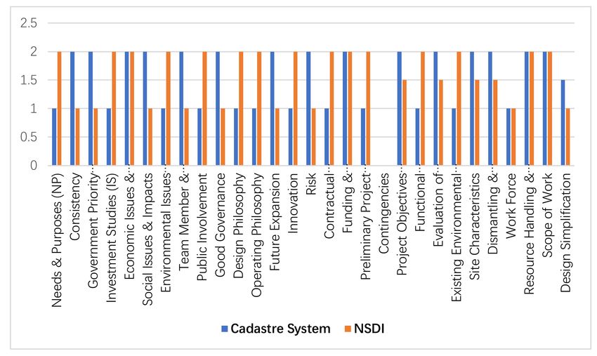
In addition to the provision of funds for the NSDI, GoP also provided funds for
1022 projects. The data collected from the planning commission indicates that out of
1023 projects completed in all 34 ministries, 62% of the total projects (i.e., 631) are related to
geospatial data. Figure 1 shows the sector-wise distribution of these projects.
From Figure 1, about 84% of projects are physical infrastructure. Almost all the infras-
tructure development projects belong to the construction industry, a vital sector of every
economy [23]. Some extensive projects include the construction of Burhan to Dera Ismail
Khan motorway, approach roads to the new Islamabad international airport, and construc-
tion of a fish landing jetty and allied harbor facilities at Pishukan, Gwadar. Some major land
sector projects include sustainable land management programs to combat desertification,
land acquisition for Swat motorway, relocation of utilities to new Islamabad international
airport, and land acquisition for CPEC. Some landmark projects in the water sector are
water conservation in the rainfed area of Khyber Pakhtunkhwa province, monitoring the
sea-level rise in Sindh, provision of groundwater for the industrial sector in Gwadar and
Balochistan, and rehabilitating the irrigation system in Punjab. Significant projects underLand 2021, 10, 188 6 of 17
the climate change set up the Geomatic center for climate change in Islamabad and the
installation of radars for weather surveillance in Karachi and Multan. The overwhelm-
ing projects in food security targeted enhancement of wheat, rice, sugarcane, and pulses
production. More projects established information systems for the food security of the
country. They improved the production and supply of quality seed to farming communi-
ties. In the IT sector, the major projects aimed at establishing the IT industry standards,
IT infrastructure for E-Offices, and NSDI for the country. Notable projects in the energy
sector projects installed solar energy units in district Chaghi of Balochistan, solar lights in
Nawabshah, Mirpurkhas, and Sukkur districts of Sindh province, and 20 MW hydropower
project in Gilgit.
Figure 1. Sector-wise distribution of geospatial projects.
Figure 2 shows the distribution of 102 geospatial projects apart from physical in-
frastructure development implemented in 27 ministries. Some important geospatial data
projects include the establishment of the national center of excellence in Big data, data-
driven smart decision platform for increased agriculture productivity, establishment of
national spatial data infrastructure (NSDI), geospatial monitoring of major and high-value
crops, sustainable land management program to combat desertification, the establishment
of the national center for the Internet of Things and mapping of historical and religious
sites in Pakistan. Table 2 shows the details of the most significant geospatial projects in
terms of budget and impact.
An enormous amount of geospatial data will be used and generated by the 631 projects
implemented in 34 ministries and 43 divisions. To facilitate the efficient sharing and
reuse of geospatial data for economic development, evidence-based decision making, and
overcoming duplication of efforts and resources, the data needs to be standardized and
managed properly through coordination, legal and institutional arrangements [14]. For
these reasons, most of the countries are implementing NSDIs. In the absence of NSDI in
Pakistan, sharing geospatial data, mostly produced by the public sector organizations, will
remain an issue [15,24].Land 2021, 10, 188 7 of 17
Figure 2. The number of ministries and geospatial projects in different themes in terms of budget and impact.
Table 2. The details of the most significant geospatial projects in terms of budget and impact.
Project Name Concerned Ministry
Updating Agro Ecological Zones of Pakistan through Satellite and In-situ Data
National Food Security and Research
Mapping
Establishment of National Spatial Data Infrastructure Defense
Geospatial Monitoring of Major and High Value Crops National Food Security and Research
Mapping of Historical and Religious Sites in Pakistan National heritage and Culture
Geological Mapping of 50 Topo sheets of Balochistan Petroleum
Cadastral Mapping Planning, Development, and Special Initiatives
Pakistan Satellite Navigation Program SUPARCO
Sustainable Land Management Program to Combat Desertification of Pakistan Climate Change
Ten Billion Trees Tsunami Program Climate Change
Relocation of Utilities to New Islamabad International Airport Communications
Land Acquisition and Resettlement for China-Pak Economic Corridor Communications
Relocation of Utilities to Lahore Ring Road Communications
Pilot Project DTMB-A-Digitization of Terrestrial Network of PTV (Chinese
Higher Education Commission
Grant in Aid)
Land Revenue Records Management System in Rural Area of ICT Phase-II,
Science and Technological Research
Islamabad
National Center for Internet of Things Information Technology and Telecom
Enterprise Resource Planning System Power
Irrigation System Rehabilitation Project Punjab Water Resources
National Pesticide Residue Monitoring System in Pakistan National Food Security and Research
Establishment of Food Security Information System National Food Security and Research
Pakistan Single Window Revenue
3.2. Implementation Issues of NSDI in Pakistan
Survey of Pakistan constituted a coordination committee on 30th June this year during
a meeting held at SoP headquarter as the first step for coordinating the NSDI implementa-
tion efforts to collaborate with the various stakeholders being the right direction according
to SDI literature [1,15,24–27]. The committee comprises 16 representatives of various fed-
eral ministries, government departments, and private companies, including SoP. During
the meeting, SoP also presented salient features of the prepared terms of reference (TORs)
for hiring a consultancy firm to conduct a feasibility study for the establishment of NSDI
for Pakistan. Then all the participants were asked to discuss and give input regarding
the TORs. The representative of private surveying and mapping companies criticized the
evaluation criteria prepared by SoP and highlighted the need to enrich the criteria givingLand 2021, 10, 188 8 of 17
more weightage to the technical capacity of the bidding firms. The academic institutions’
representatives pointed out that the bidding firms having SDI professionals as permanent
staff should be given due consideration in TORs. They also mentioned that institutional
aspects are more challenging than technical, while implementing SDIs. Therefore, TORs
need appropriate attention to these aspects. The representative of federal government
departments stated that a legal framework is essential for the NSDI.
After much effort, the finalized TORs were published on the Public Procurement
Regulatory Authority (PPRA) and the SoP websites, advertised in the national newspapers,
and shared on social media. Later the SoP noticed the deadline of 34 days is not enough
for submitting proposals, especially for international firms. Some foreign firms reported
the unavailability of any suitable and reliable local firm for the association. Consequently,
the local firms, being inexperienced in the field of SDI, could not technically qualify, due to
the lack of capacity required for such studies. We concluded the most impeding factors for
the NSDI establishment in Pakistan include a relatively short time duration for proposal
submission, capacity issues of foreign and local firms, and risks involved, due to the
ongoing COVID-19 pandemic.
4. Materials and Methods
The study designed a framework that includes the following sub-steps. The first step is
to identify the relevant key stakeholders. Among the government of Pakistan and national
and international firms, SoP has a pivot role as the executing agency of both the initiatives,
i.e., NSDI and cadastre system. With this role, SoP faces a difficult situation, due to several
limitations pertaining to the technical and organizational capacities of the organization.
Therefore, it is essential to decide which project should get priority or any possibility to
work on both projects simultaneously, and in doing so, what are the overlapping areas
between the two projects.
The second step is a survey based on official documents, such as project propos-
als, minutes of meetings, in addition to data collected through a questionnaire and from
key stakeholders identified in the first. Questions were formulated to determine the
organization’s characteristics (in terms of type, size, level, roles, and resources), usage,
demands/needs, motivations, and relationships with other stakeholders. To analyze this,
we adapted the evaluation framework developed by Hansen et. al [28] (see Table 3 for
details). It identifies decision criteria based on a systematic review of the literature. We
performed a systemic literature review and identified 34 decision criteria for infrastructure
projects. We organized the criteria into five groups: (Group-I) strategic fit, (Group-II)
owner philosophies, (Group-III) project funding and timing, (Group-IV) project require-
ments, and (Group-V) value engineering. After critical examination, only 29 criteria were
included being relevant in the context of this study. For instance, from group-II, the de-
cision criteria “maintenance philosophy” was not considered to be too specific to civil
engineering projects. Similarly, from group IV, criteria “determination of utility impacts”
and from group V, criteria “value engineering procedures”, “material alternatives”, and
“constructability procedures” were not considered. Therefore, these criteria were marked
as “not considered”. We formulated a questionnaire to take input from stakeholders on
items in Table 3.
The third step refers to a survey data analysis to compare the cadastre system and
the NSDI projects through the adapted evaluation framework. For data acquisition, the
questionnaire was distributed among the respondents to assign a score from 0 (least
important) to 2 (most important) to each decision criterion. To accomplish the survey
campaigns, SoP frequently organized meetings where representatives from the public
and private organizations were invited to give feedback for the NSDI establishment and
Cadastre system in Pakistan. The sampling scheme consists of 100 federal government
and provincial government organizations engaged in spatial data production, academia,
and private surveying and mapping companies. The respondents were representatives
from the key organizations, including 5% from SoP as the executors, 15% represent variousLand 2021, 10, 188 9 of 17
federal government departments, 30% representatives from provincial governments, 28%
represent academia, and 22% representatives from private companies.
Table 3. Decision criteria identified by Hansen et. al [28] for infrastructure projects. The criteria are organized into five
groups: (Group-I) strategic fit, (Group-II) owner philosophies, (Group-III) project funding and timing, (Group-IV) project
requirements, and (Group-V) value engineering.
Group Decision Criteria Cadastre System NSDI
1. Needs and Purposes criterion Economic development, to solve Economic development saves spatial
analyzes the needs and purpose of a ongoing land disputes between data collection and management cost,
project in the light of its importance. people, and to stop and reclaim state and overcome duplication efforts for
Group-I land encroachment. spatial data.
Strategic Fit (SF) 2. Consistency criterion analyses the The project perfectly aligns with SDGs The project is in accordance with
This group comprises ten criteria and alignment of the project with national adopted by the GoP. And large-scale e-Government initiative being
focuses on project issues. development goals and strategic data for security forces is also required implemented since 2005.
defense aims. for precise counter-terrorism
activities.
3. Government Priority criterion The project is the priority of GoP. It is important, but is not a priority of
analyses the project’s importance GoP.
regarding the national economy at
national and regional levels.
4. Investment Studies criterion is Detailed and high resolution data of For evidence-based development
related to the feasibility and other the project is extremely needed for planning, multiple spatio-temporal
investment studies required during a “precision agriculture” [29] and datasets are required, which can only
project planning process. economic development in Pakistan. be available through NSDI.
5. Economic Issues and Impacts: This The project would boost the The project would reduce duplication
criterion is concerned with examining construction industry of the country, of financial resources, and therefore,
the issues and effects of a project in and therefore, positively impact would have a positive impact on the
relation to the economy. economic development. economy.
6. Social issues and impacts of the Food security, poverty alleviation, and Social issues, such as clean drinking
project. better housing facilities are all social water, better housing, and health
issues faced by the country. The facilities require multiple datasets
detailed project data would help to presently not accessible would
overcome these issues. become available through NSDI.
7. Environmental Issues and Impacts This project will partially be useful to Pakistan faces various environmental
criterion focuses on the issues and overcome environmental issues, such issues, such as air pollution, loss of
impacts of the project concerning the as the loss of green areas. biodiversity, solid waste management,
environment. and climate change. Climate change is
a crucial threat to Pakistan [30].
Twenty-two datasets were identified
by [31] to combat climate change.
NSDI would have a positive impact
being a data-sharing initiative.
8. Team and Stakeholder Coordination Poor coordination has been observed There is lack of coordination for NSDI
criterion analyzes the coordination among the stakeholders. development in Pakistan [32].
among the team members and
stakeholders of the project.
9. Public Involvement criterion is Although the public is not involved in No direct involvement of the public,
concerned with the fact that how the project. Moreover, resistance from however, the representatives of
much the public is involved with the local governments does exist. various sectors are on board [33].
project and what is their attitude
regarding the project.
10. Good Governance: This criterion The project outcome will contribute to The project outcome will contribute to
analyzes the contribution of the achieving good governance as illegal achieving good governance.
project towards good governance. land occupation is one of the critical
causes of corruption in Pakistan.
Group-II 11. Design Philosophy criterion The project is not well designed so far, The project is well designed and in
Owner Philosophies focuses on the design of the project to due to the urgency of the GoP. accordance with set norms of the
This group consists of seven criteria ensure its success. planning commission.
and focuses on the necessary 12. Operating Philosophy criterion SoP does not possess sufficient SoP does possess sufficient capacity to
information, which is needed to examines the level of service, which is capacity to complete the project carry out a feasibility study, but as per
understand the project from the required at a sufficient capacity over within one year. GoP’s rules, it has to be carried out by
owner’s perspective. an extended period. a third party.
13. Maintenance Philosophy criterion Not considered Not considered
focuses on the maintenance of the
project.
14. Future Expansion criterion is The project is likely to expand after a No further expansion.
concerned with any possibility successful pilot project.
regarding the alteration or expansion
of the project in the future.
15. Innovation criterion assesses the The outcome will contribute to The outcome will contribute to
innovation of the project. bringing innovation to the land bringing innovation to not only the
market. land market, but also in many other
sectors.
16. Risk criterion assesses the level of The highest risk is the limitation of No risk of time, however, being a long
risk, which is involved with the time, i.e. one year. term project, changing priorities of the
project. coming governments may hamper the
project.
17. Contractual Conditions and Finalized, but guidelines to check the Bit tough contractual conditions, such
Procurement criterion examines the quality of outsourced work not yet as at least one year of experience does
conditions and models which the ready. exist in the ToRs.
project takes into consideration.Land 2021, 10, 188 10 of 17
Table 3. Cont.
Group Decision Criteria Cadastre System NSDI
Group-IIIProject Funding and Timing 18. Funding and Programming No issue of funding as GoP is No issue of funding as GoP is
This group comprises of three criteria criterion deals with the funding and providing funds. providing funds.
dealing with the objectives of the programming sources of the project.
project, which are related to the 19. Preliminary Project Schedule Despite having a preliminary project Well planned schedule does exist;
funding and timing constraints. criterion deals with the schedule of schedule, achieving the set milestones however, COVID-19 may impede
the project could not be possible in the planned achieving the set milestone.
time frame.
20. Contingencies criterion is No contingency plan to mitigate the No contingency plan to mitigate the
concerned with the contingencies in project’s risks. project’s risks.
order to calculate the risks of the
project.
21. Project Objectives Statement The project objectives are difficult to Almost all the objectives are
criterion is concerned with the achieve, due to quite a short time achievable.
objectives of the project. period.
Group-IV
22. Functional Classification and Use The project is for public welfare and The project is for public welfare and
Project Requirements
criterion is concerned with the use. use.
This group comprises of ten criteria,
functionality of the project, which
which are concerned, with the
would be either public or private.
requirements of the project.
23. Evaluation of Compliance criterion The project will complement the Among others, the project will
is used for analyzing the requirements existing plan of NSDI-Pakistan and support the existing plan of
of the project according to the existing Naya Pakistan Housing Program [34]. E-Government, SDGs, and Pakistan
plans, standards, and regulations. single window [35].
24. Existing Environmental Poor existing environmental Good existing environmental
Conditions criterion is concerned with conditions. conditions.
examining the existing environmental
conditions for the sake of making
better decisions.
25. Site Characteristics criterion The site is good enough for the project. There is a discrepancy between the
analyzes the difference between the available site characteristics and the
existing characteristics and required required site characteristics. However,
characteristics. a separate office will be constructed.
26. Dismantling and Demolition No such issue of dismantling and Presently no issue, but the
criterion is concerned with the demolition. implementation stage may be
requirements, which are related to the problematic.
dismantling and demolition of the
project.
27. Determination of Utility Impacts Not considered Not considered
criterion analyzes the adjustment of
the utilities for the designing and
construction of the project.
28. Work Force criterion analyzes the Not sufficient work force is available Not sufficient trained work force is
work force needed for the project. in the department. available in the department.
29. Resource Handling and Utilization The available human and technical The available human and technical
criterion is concerned with the resources are being utilized properly. resources are being utilized properly.
handling and utilizing the resources
for the project.
30. Scope of Work criterion examines Well defined scope of work. Well defined scope of work.
the scope of work of the project.
Group-V 31. Value Engineering Procedures Not considered Not considered
Value Engineering criterion analyzes the project for
This group consists of four criteria, consisting of value engineering
which examine the function of the procedures.
project to enhance its value. 32. Design Simplification criterion The specifications of the project Will be determined after a feasibility
focuses on simplifying the design of design could not be well defined, due study.
the project. to time limitations.
33. Material Alternatives criterion Not considered Not considered
focuses on alternatives materials to
use in the project.
34. Constructability Procedures Not considered Not considered
criterion is concerned with the
construction constraints of the project.
5. Results
5.1. Stakeholders Analyses for Cadastre System
The study identified high-level stakeholders from the federal and provincial gov-
ernments. These governments further consist of ministries, divisions, sub-divisions, de-
partments, and authorities running several projects initiated by the current government.
For instance, Naya Pakistan Housing and Development Authority (NAPHDA) is running
under the ministry of planning, development, and special initiatives, known as the plan-
ning commission of Pakistan, Billions Tree Tsunami initiative is running under the climate
change ministry, SoP is working under the ministry of defense. Other relevant ministries
include Finance and Revenue, Industries and Production, National Food Security and
Research, Water Resources, Forests, and Rangelands, among 34 ministries. The planningLand 2021, 10, 188 11 of 17
commission of Pakistan is an apex federal body led by the Prime Minister. It has a mandate
(i) to release all funds to other departments, (ii) to manage Pakistan’s socio-economic
development strategically and sustainably, and (iii) to providing state land data. NAPHDA
is a newly established corporation to deals with planning, development, construction, and
management of real-estate schemes and housing projects of the current government. SoP
is responsible for the on-ground execution of land-related projects, including surveying
land, collecting attribute data, preparing digital cadastral maps, and integrating these
maps with land record management systems of provincial boards of revenues. The PM
Office, however, identified the NAPHDA, SoP, and the planning commission as the major
stakeholders of the cadastre system.
5.2. Stakeholders Analyses for NSDI
There are 34 ministries under which 43 divisions administratively function at the fed-
eral level in Pakistan (http://www.pakistan.gov.pk/index.html, accessed on 23 November
2020). Hundreds of departments are working under the 43 divisions. Similarly, there is a
long list of private companies dealing with surveying and mapping activities. Although,
it is mandatory for these companies to register with SoP according to the surveying and
mapping act, 2014 [22], but, so far, only 62 companies have registered as mentioned on
the website of SoP (http://sop.gov.pk/, accessed on 23 November 2020). The purpose of
registering these companies is to regulate the geospatial industry and also to determine the
size of the industry of Pakistan. Many NGOs and academic institutions are also dealing
with geospatial data. In principle, these all are stakeholders of the NSDI.
5.3. Survey Data Analysis
After receiving scores from all, Figure 3 shows the average calculated scores. Out of
the total 58 points, the obtained scores for the cadastre and the NSDI was 43.5 (75%) and
45 (77.6%), respectively. Figure 3 indicates the weak areas of the cadastre project spread
almost evenly over all groups. The weak areas include needs and purposes, investment
studies, environmental issues and impact, public involvement, design, and operating
philosophy, innovation, contractual conditions, and procurement model, preliminary
project schedule, functional classification, and use, and environmental conditions. The
NSDI initiative proved weak in some criteria. The main impediments for the NSDI project
include lack of consistency, government priority, social issues and impacts, team members
and stakeholder coordination, good governance, future expansion, risk, unclear and wide
objectives, evaluation of compliance, and site characteristics.
Figure 3. Average calculated scores for each Cadastre and NSDI criterion.Land 2021, 10, 188 12 of 17
6. Discussions
This study evaluated the two national-level mega-projects recently initiated by the SoP,
i.e., NSDI and the national cadastre system. To do so, it adopted a framework developed
by Hansen et. al [28] and compared the two projects on 29 criteria ranking to a total of
58 points. The overall comparison shows the NSDI is relatively more important for the
Pakistan government. Similarly, the alignment of the NSDI with national development
and defense goals is well established. However, compared to NSDI, the cadastre project
is a priority for the Pakistan government, which is of utmost importance for authorities
to achieve their political objectives. The prime minister personally monitors the progress
of the cadastre project. It shows the government’s keen interest in the project. Besides,
we analyzed the NSDI is more effective in addressing social issues and good governance.
However, NSDI has several risks being a long-term project spreading over 6-10 years, and
the too broad objectives of the NSDI. On the other hand, the objectives of the cadastre
system are clear, short-term, and of political nature. For example, the cadastre system is a
prerequisite for the NAPHDA program announced by the government. ToRs for the NSDI
establishment available on the SoP website (http://sop.gov.pk/, accessed on 23 November
2020) shows the implementation of the project would require establishing a new secretariat.
Presently, the design specifications for the NSDI are not explicit and would be available
after the completion of phase-I of the project, i.e., feasibility study.
Both the initiatives (i.e., reforming and modernization of the cadastre system and
establishment of NSDI) follow a top-down approach. The cadastre project started with the
PM directive, and the NSDI started following Surveying and Mapping Act 2014 [22] passed
by the federal government. The provincial governments maintain cadastre records through
their boards of revenues. The forest departments in all the provinces hold records for most
of the state land. Moreover, the Auqaf departments in all provinces are the custodian
of land records of religious sites in the country. The key stakeholders are the province
governments, boards of revenues, forest, housing, and Auqaf departments of all provinces.
Private stakeholders from the housing sector include only housing societies and the defense
housing authority. Almost all the stakeholders are provincial government departments,
whereas the project executing agency (i.e., SoP) is a federal government department. It cre-
ates a vertical hierarchy of state power, and therefore, provincial government departments
are reluctant to give access to their land record. Thus, the project progress suffers, due to
the lack of coordination between the federal and the provincial governments.
The scores for both the cadastre and the NSDI projects are similar, i.e., 43.5 (75%)
vs. 45 (77.6%), respectively. It is because about 87% of respondents perceive that through
establishing NSDI, GoP can eliminate redundancies and duplication of data collection
and promote the harmonization, dissemination, and use of spatial data. However, the
cadastre data serves as one of the core data sets required for the successful implementation
of NSDI, including topography, hydrology, administrative boundaries, geographic names,
and geodetic framework. Therefore, the survey respondents perceive that the cadastre
development (i.e., parcel-level geospatial data) will ultimately be a part of the NSDI
implementation.
Policy guidelines for Cadastre system development in Pakistan
The present study found several findings based on which the following suggestions
can be incorporated for the proper implementation of Cadastre system development in
Pakistan.
• The survey respondents from SoP Peshawar raised the issue of the definition of state
and government land. They believed the state land and government land are two
different concepts, whereas GoP has used the two terminologies interchangeably with
the same meaning. The issue was well taken by the SoP top officials who empha-
sized to resolve it for the proper implementation of Cadastre system development in
Pakistan.
• The survey respondents from the federal organizations noticed the list of identified
stakeholders is highly shallow for the cadastre system development in Pakistan. ForLand 2021, 10, 188 13 of 17
instance, the list excludes the provincial forest departments being the prime custodian
of state land in all provinces. Similarly, the Auqaf departments were missing, which
are the custodian of religious sites, e.g., mosques, temples, and shrines in all the
country provinces. Therefore, SoP was not able to access land records possessed by
these departments. Similarly, private housing schemes, defense housing authorities,
and military land cantonments were missing from the stakeholders’ list.
• During survey campaigns, a political issue highlighted by the respondents is provin-
cial organizations in Sindh and Balochistan, being non-allies of the ruling party, should
be aligned with the federal organizations to fasten the project’s progress. The BoRs
should give access to land records in these provinces for the smooth implementation
of the project.
• A technical issue highlighted by the respondents is the obsolete spatial reference
system used in paper maps. It demands the definition of a new, unified, and standard
reference system for the project to overcome data integration issues. Accuracy is
questionable, due to centuries-old maps and distorted relevant paper records.
• Due to limited human resources, SoP is hiring consultancy firms for cadastral map-
ping. However, it requires setting up a monitoring and evaluation (M&E) office to
ensure data integration from all the consultancy firms.
• Cadastral mapping demands a dense geodetic control network of very high accuracy.
Such a network does not exist so far. It will seriously affect the accuracy of cadastral
maps. Moreover, the integration of the cadastre data will be problematic.
• The survey respondents from all public and private organizations highlighted a
standard data model is crucial to the cadastre system development in Pakistan. Since
there is no national cadastral system in Pakistan, all the provinces implement different
data models and often do not give access. Therefore, a single data model may not
be sufficient to integrate existing land records from all the provinces. No study
conducted so far to analyze the issue of harmonizing different data models at the
provincial level.
Policy guidelines for NSDI development in Pakistan
The present study findings recommend the following policy guidelines for the proper
NSDI establishment in Pakistan.
• During the survey campaigns, the respondents from public departments at the provin-
cial level showed reluctance to the NSDI establishment, since most of the stakeholders
for the NSDI project are public sector organizations at the federal government level.
However, the private sector organizations and academia showed immense interest in
the NSDI establishment, which is a healthy sign for the long-term implementation
of the initiative [24]. For the successful NSDI implementation in Pakistan, we sug-
gest increasing the stakeholders from both public and private organizations at the
provincial level.
• About 78% of the survey respondents found the NSDI project faces the limited ca-
pacity of national and international firms besides that of SoP, tough ToRs for hiring
consultancy firms, the time duration for proposal submission, and the prevailing
COVID-19 situation around the globe. While the cadastre project faces main con-
straints from the limited access to land records, distorted and paper-based records,
different data models, lack of coordination, political conflicts of stakeholders, lack of
trained staff, and the SoP’s limited human resource capacity.
• About 98% of respondents from the private sector organizations raised issues of
national data sharing policy. Presently, the survey of Pakistan, the custodian of
core data sets, poses strict restrictions on their share and reuse. To fulfill the spirit
of both the Cadastre system and NSDI, they suggested the SoP should revisit their
policies regarding data sharing and reuse. Decision-makers, civil servants, researchers,
professionals, and even civil society should be able to access spatial datasets through
standard web services for better policy-making. It requires revisiting national spatialLand 2021, 10, 188 14 of 17
data policy for disseminating geospatial data, and achieving it, develops practical
tools (e.g., national geoportal).
• About 90% of the survey respondents from federal organizations suggested systemat-
ically assessing the SoP’s present and future needs regarding the necessary resources
required for the successful development/implementation of Pakistan NSDI. Such
assessments should analyze the SoP (institutional) capacity: (i) To undertaking and
managing the NSDI, (ii) to delivering the necessary services to its potential users, and
(iii) to proposing the optimal arrangement, and structure to ensure the seamless provi-
sion of such services. It means that a thorough assessment of the ground situation at
SoP needs to take place based on a checklist derived from SDI Components [36], CO-
BIT [37], and IGIF (https://ggim.un.org/) pathways. Such detailed assessments are
only possible by organizing in-depth interviews/discussions with key stakeholders
(particularly with the SoP staff members).
• Some respondents suggested enhancing the capability of SoP in leadership, someone
who promotes and coordinates the NSDI development. Because leadership remains
one of the challenges and risks considered critical in the execution of mega-projects
like NSDI and the national cadastre system. Therefore, investigations are required to
analyze the capability of stakeholders for outreach and capacity building activities,
which specifically lead to political support for NSDI. According to the previous
works and the literature, in the stand-alone stage of organizational development, the
individual organizations do not consider the NSDI as such, and as a result, NSDI
leadership is lacking. It is widely considered a risk factor for failure of NSDI, which
should be addressed by planning for the awareness of the importance of coordination
and increasing the likelihood of introducing potential leaders. This process would
result in the accepted leadership of one or a limited number of entities. Such a
leadership should satisfy the geospatial community.
• Management of information and good governance are the two important elements
that must work together to form the bases of effective decision-making. There must
be a synergistic relationship between good governance and information whereby
good governance creates a healthy legal, institutional, and socio-political-economic
framework for information to flow, and the information flow, in turn, facilitates sound
decision-making for good governance. Therefore, decision-making requires the sup-
port of legal, institutional, and technological frameworks that enable equitable access
to information and transparency of decision-making across government, private
sector, and the community. The NSDI development is, thus, vital to good governance.
• Agriculture plays a key role in the economic development of Pakistan [38]. However,
its contribution to the gross demotic product GDP is declining for the last decade.
The country is in dire need to promote digital and precision agriculture to increase
agriculture production and reduce costs. These initiatives might take advantage of
the NSDI development and availability of geospatial data in the process of digital
transformation to become more efficient (and to cut costs) to deliver improved and
new services to innovate.
One limitation of the study might be the stakeholders of both the cadastre and the
NSDI projects belong to national federal, and provisional organizations. It is partially due to
both projects are in the initial stage. Future studies should focus on identifying international
donor organizations that often support developing countries in these projects. For instance,
the World Bank often finances the developing countries for national Geoportal and NSDI
standards, building up institutional capacities, improving technical infrastructure (e.g.,
communication networks, WEBGIS). Future studies may identify international donors like
Food and Agricultural Organization (FAO), USAID, Swedish International Development
Cooperation Agency (SIDA), State Secretariat for Economic Affairs (SECO), and German
Agency for Technical Cooperation (GTZ) as potential stakeholders.Land 2021, 10, 188 15 of 17
7. Conclusions
This study evaluated the value of two development initiatives for the National Spatial
Data Infrastructure (NSDI) and the cadastre system in Pakistan using the 29 evaluation criteria.
Results show, out of the total 58 points, the obtained scores for the cadastre and the
NSDI was 43.5 (75%) and 45 (77.6%), respectively. There are overlapping areas between
the two projects; however, both projects are not the same in terms of scope and volume.
Cadastre remains a core data set in NSDIs, including orthophotomaps, topography, hy-
drology, administrative boundaries, geographic names, and geodetic framework. Whereas
the dissemination of geographic information in NSDIs is not only limited to land parcels,
but also other geospatial and thematic data sets, e.g., satellite imagery, transport networks.
Therefore, about 87% of respondents perceive that through establishing NSDI, GoP can
eliminate redundancies and duplication of data collection and promote the harmonization,
dissemination, and use of geospatial data. Thus, the study concludes that the cadastre
development (i.e., parcel-level geospatial data) should be a part of the NSDI project.
For an agriculture-based economy like Pakistan, efficient and effective geospatial infor-
mation is necessary for evidence-based policy-making to increase agricultural production
and the national GDP. The study concludes that the NSDI development will return more
economic benefits to the governments at the provincial and federal levels. For this, however,
SoP has a limited capacity of human and technical resources. Therefore, we recommend
the continuation of NSDI feasibility for one year through hiring experienced consultancy
services. Besides, we urge to resolve the political conflicts between the governments at
different levels. The provincial organizations in Sindh and Balochistan, being non-allies of
the ruling party, should be aligned with the federal organizations to fasten the project’s
progress.
Both projects are significant for the country in terms of value, cost, and scope. Policy
guidelines from this research output will help policy-makers better plan and run both
megaprojects and set key organization characteristics, such as priority, type, level, and role.
Author Contributions: The study is carried out as a part of research by A.A. (First Author) under
the supervision of M.I. (Corresponding Author) at the Institute of Geo-information & Earth Obser-
vation (IGEO), University of Arid Agriculture, Rawalpindi, Pakistan. The first author conceived,
designed the study, and conducted the survey and the experiments; A.A. and M.I. performed the
statistical analysis and wrote the paper. All authors have read and agreed to the published version of
the manuscript.
Funding: This research received no external funding.
Institutional Review Board Statement: Not applicable.
Informed Consent Statement: Not applicable.
Data Availability Statement: The data presented in this study are available on request from the
corresponding author.
Acknowledgments: The authors acknowledge the assistance in the data gathering by Survey of
Pakistan, which is greatly appreciated.
Conflicts of Interest: The authors declare no conflict of interest.
References
1. Rajabifard, A.; Feeney, M.E.F.; Williamson, I. Spatial Data Infrastructures: Concept, Nature and SDI Hierarchy; Taylor Francis Group:
London, UK, 2003.
2. Krek, A. Geographic information as an economic good. In GIS for Sustainable Development; CRC Press: Boca Raton, FL, USA, 2006;
pp. 85–103.
3. Castelein, W.T.; Bregt, A.; Pluijmers, Y. The economic value of the Dutch geo-information sector. Int. J. Spat. Data Infrastruct. Res.
2010, 5, 58–76. [CrossRef]
4. FAO; World Bank; UN-Habitat. Measuring Individuals’ Rights to Land an Integrated Approach to Data Collection for SDG Indicators
1.4.2 and 5.a.1; World Bank: Washington, DC, USA, 2019. Available online: https://openknowledge.worldbank.org/handle/1098
6/32321 (accessed on 13 November 2020).You can also read