Northland Plan: Volume II - City of Columbus
←
→
Page content transcription
If your browser does not render page correctly, please read the page content below
Northland
Plan:
Volume II

City of Columbus:
Michael B. Coleman, Mayor

Department of Development:
Mark Barbash, Director
Trudy Bartley, Deputy Director

Planning Division:
Stephen R. McClary, Administrator
Elizabeth A. Clark, AICP, Assistant Administrator
Kevin J. Wheeler, Long Range Planning Manager

Prepared by:
Jonathan C. Pawley, Senior Planner

Graphics:
Daniel Thomas, Urban Design Manager
Elsie Thomas, Graphic Designer

Northland Plan-Volume II was adopted by City Council on June 24, 2002 as the official plan for the
Northland area, to be used in conjunction with Northland Plan-Volume I.
Columbus City Council

Matthew D. Habash, President
Richard W. Sensenbrenner, President Pro-Tem
Kevin L. Boyce
Jennette B. Bradley
Michael C. Mentel
Maryellen O’Shaughnessy
Charleta B. Tavares

Columbus Development Commission

Michael J. Fitzpatrick, Chair
Dan D. Frye, Vice-Chair
Paul Cianelli
A. Robert Hutchins, Esq.
Karen J. McCoy
James E. Simpson

This plan, in conjunction with Northland Plan-Volume I, provides guidelines for private and public sector decision
making in the Northland area. Please direct all questions regarding the content of this document to the
Columbus Planning Division, 109 North Front Street, Columbus, Ohio 43215.
Dear Citizen:

On June 24, 2002, Columbus City Council adopted Northland Plan – Volume II as the city’s official long-range
guide for development, redevelopment and improvement of the physical environment in portions of northeast
Columbus. Northland Plan – Volume II is generally bounded by I-270 on the west, portions of Central College
Road and State Route 161 to the north, Morse Road to the south, and Columbus corporate limits to the east.
This plan was prepared with the assistance of and input from numerous stakeholders including civic leaders,
property owners, representatives of the business community, public agencies, and Northland Community Council.

In conjunction with this plan, and to help address some of the challenges facing the Northland community,
the city has also produced the Northland Plan – Volume I, the Morse Road Market Analysis and Redevelopment
Strategy, and the Morse Road Design Study.

The Northland community has been and will continue to be a vital part of Columbus. It is our goal that this
document be used by the private and public sectors as a working reference of planning guidelines and policies
for this portion of Columbus. I want to thank everyone involved in the creation of Northland Plan – Volume II,
and ask that you continue to be a part of our on-going efforts to build a better Columbus.

Sincerely,

Mark Barbash, Director
Department of Development
acknowledgements

                                                                                                                      acknowledgements
The Planning Division would like to acknowledge former staff members Nan Merritt, Angela Mingo, and Katie
Martin Renner (Senior Planners), who made substantial contributions to this plan.

The Northland Community Council, in particular the Northland Development Committee formerly chaired by
Andrew S. Bukovinsky, and currently chaired by Jeff S. Murray, contributed a great deal of time and energy
to this effort. In addition, we acknowledge the commitment and dedication throughout the process from the
planning working group, comprised of civic leaders, property owners, and representatives from the business
community. Their assistance was invaluable.

Special thanks also go to the Little Turtle Country Club, 5400 Little Turtle Way, for hosting the numerous planning
sessions and public hearings that helped shape the formulation of this plan.
northland plan: volume II
table of contents

                    purpose/introduction                1-2   zoning & annexation                    49-57
                                                              Ø Annexation Patterns                  50-51
                    issue identification                 3    Ø Existing Land-Use Patterns           52-54
                                                              Ø Existing Zoning                      55-57
                    background                         4-11
                    Ø Area History                      6-7   proposed land-use                      58-69
                    Ø Neighboring Jurisdictions         8-9   Ø Proposed Land Use                       59
                    Ø Population                         11   Ø Little Turtle District               60-61
                                                              Ø Blendon District                     62-63
                    natural resources                 12-15   Ø Preserve District                    64-65
                    Ø Introduction                       13   Ø General Land-Use Guidelines          66-68
                    Ø Waterways and Floodplain           13   Ø Development Standards                   69
                    Ø Forested Areas and Wetlands        14
                    Ø Protected Areas                    14   list of contacts                         70

                    community facilities & services   16-28   maps
                    Ø Fire Services                      17   Ø Planning Area                           5
                    Ø Police Services                    18   Ø Neighboring Jurisdictions              10
                    Ø Schools                            20   Ø Waterways                              15
                    Ø Street Lighting                    22   Ø Fire and Police Stations               19
                    Ø Parks                           23-24   Ø School Districts                       21
                    Ø Recreation Facilities              26   Ø Area Parks                             25
                    Ø Trails and Greenways               28   Ø Community Recreation Centers           27
                                                              Ø Thoroughfare Plan                      31
                    transportation                    29-42   Ø Roadway Improvements                   36
                    Ø Circulation                        30   Ø Public Transportation                  39
                    Ø Thoroughfare Plan               30-32   Ø Columbus Water Facilities              45
                    Ø Improvements                    33-36   Ø Columbus Sanitary Sewer Facilities     48
                    Ø Public Transportation           37-39   Ø Annexation Patterns                    51
                    Ø Pedestrian Facilities              40   Ø General Existing Land-Use              54
                    Ø Bicycle Facilities                 41   Ø General Existing Zoning                57
                    Ø Future Trends                      42   Ø Planning District                      59
                                                              Ø Little Turtle District                 60
                    water & sewer services            43-48   Ø Blendon District                       62
                    Ø Water                           44-45   Ø Preserve District                      64
                    Ø Sanitary Sewers                 46-48
                    Ø Storm Sewers                       47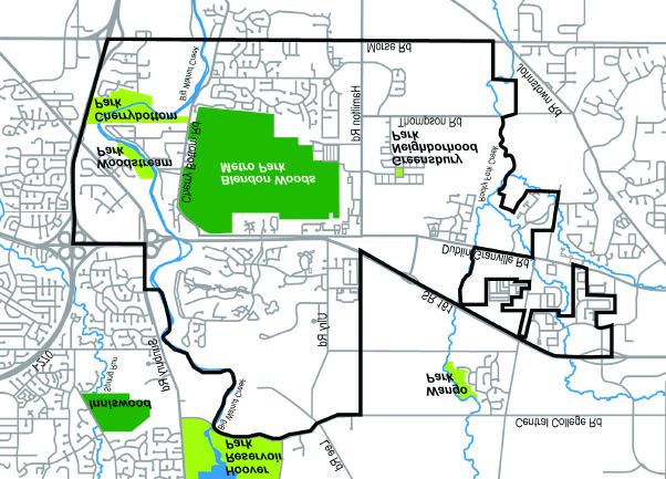
purpose
purpose

          1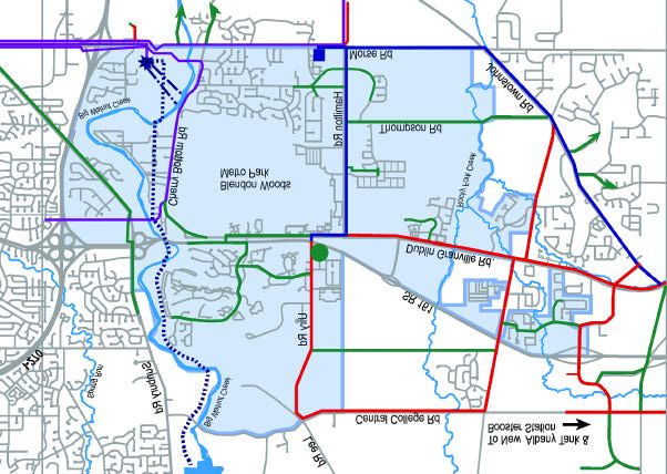
purpose
purpose/introduction

                           Northland Plan-Volume II will be used as a principle reference document by developers, neighborhood
                           organizations, city staff, the Development Commission, and City Council when making decisions concerning
                           the physical development of the planning area.

                           introduction

                           The creation of this plan commenced during the update process of the 1989 Northland Plan. During the
                           update process, three distinct plan elements were found to be necessary. These elements were the update of
                           the 1989 Northland Plan, a new plan for the portion of the Northland Community Council east of I-270 (separate
                           from the area included in the Rocky Fork-Blacklick Accord land-use plan), and the Morse Road Market Analysis
                           and Design Study.

                           This plan, Northland Plan-Volume II, generally covers the area bounded by I-270 on the west, portions of Central
                           College Road and State Route-161 to the north, Morse Road to the south, and follows city of Columbus corpo-
                           rate limits to the east. No prior plans exist in this area.

                           Northeast Columbus has experienced extraordinary growth in recent years. Extensive residential and
                           commercial development in the area, along with the construction of the State Route 161 highway, has
                           generated higher traffic volumes and increased requirements for community services and facilities. The
                           area is comprised of numerous civic associations represented by the Northland Community Council.

                           Northland Plan-Volume II is a cooperative effort between the Northland Community Council and the city
                           of Columbus to provide guidelines for decision-making concerning the area. A planning advisory group
                           representing public and private interests worked together to develop this plan. Included in this process and
                           the subsequent creation of the plan, were numerous public input, review, and comment periods, which identified
                           issues pertaining to the planning area, and potential solutions. Each draft of the plan was scrutinized by area
                           citizens, city agencies, stakeholders from the development community, public schools, adjacent jurisdictions,
                           and other government agencies.

                       2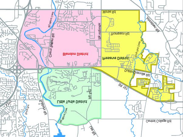
issue identification

                                                                                                                        issue identification
The initial focus of the planning advisory group was to address issues associated with growth and development
in the area. Of immediate concern to the community was traffic congestion and management, land-use and
zoning patterns over the past several years (amount of multi-family vs. single-family residential construction
occurring in the planning area), and protection of natural features and parkland. From the outset of the planning
process, the planning advisory group focused on these concerns and potential solutions. Goals emerging from
this process included:

w    Develop a community plan similar to and in conjunction with the updated Northland Plan.

w    Increase traffic management in the area.

w    Develop adequate neighborhood parks and supporting community facilities.

w    Encourage clustering of residential uses to promote open space and preserve natural features.

w    Evaluate development standards that could be applied to new development and redevelopment in the area.

w    Encourage high-quality residential, commercial, and office development.

w    Reduce the perceived isolation of the Little Turtle community from the rest of the planning area south of
     State Route 161.

As the planning process unfolded, the community identified several additional issues that ultimately helped
shape the structure and organization of the plan. Northland Plan-Volume II is a tool to encourage quality
development and a proper mix of residential, commercial, and recreation/open space land-uses. The plan is
divided into six subject areas:

 Ø    Natural Resources
 Ø    Community Facilities & Services
 Ø    Transportation
 Ø    Water & Sewer Services
 Ø    Zoning and Annexation
 Ø    Proposed Land-Use

Each section of the plan contains a discussion of the background or existing conditions relating to the subject
area. Planning issues are identified and recommendations and implementation strategies included address each
planning issue.

                                                                                                                    3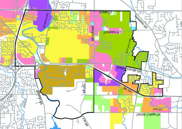
background
background
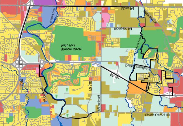
4planning area
background/planning area
The Northland planning process involves two distinct areas within the boundaries of the
Northland Community Council. Northland Plan: Volume I was adopted by Columbus City
Council on January 29, 2001.
This plan (Northland Plan: Volume II) covers a portion of the city to the east of I-270,
excluding the area covered by the Rocky Fork-Blacklick Accord.
5area history
background/ area history
American Indian Settlements
Ohio has a rich heritage of American Indian life. The territories of the Wyandot, Mingo and Delaware seem to
most often intersect with the planning area, but place names also reveal Miami and Shawnee heritage. For
example, Little Turtle of the Miami, and Blue Jacket of the Shawnee are well-known names in the area.
Little Turtle, whose Indian name was Michikinqua, was a Miami chief, known to be a brilliant military leader. He
guided the battles that led to both Harmar's and St. Clair's defeats. He advocated for peace before leading a
small group into the Battle of Fallen Timbers, where they were defeated. This led to the signing of the Treaty of
Greenville in 1795. Blue Jacket was a Shawnee warrior and chief, known for his bravery. Both chiefs, along with
those of many other tribes signed the Treaty of Greenville, which likely facilitated settlement of the planning area.
Blendon Township
Blendon Township was called Harrison Township between the time it was split-off from Sharon Township in
1815 and when the County Commissioners changed the name to Blendon in 1825. The earliest known settlers
were Edward Phelps and Isaac Griswold, both arriving from Connecticut in 1806. Mr. Phelps is said to be the first
settler to have felled a tree in the township, apparently an important event considering the tremendous effort it
took to clear the thick forest enough to establish a homestead. Isaac Griswold was the first postmaster of the
crossroads community called Blendon Four Corners, at the intersection of Granville Road and Columbus-
Westerville Pike.
A school in the hamlet of Central College, to the immediate west of the planning area, supervised and staffed by
Reverend Ebeneezer Washburn, was made into the New School branch of the Presbyterian Church in 1835
when 'Squire Timothy Lee offered 100 acres to establish an institution of higher learning. This complex includes
five buildings on the National Register of Historic Places:
w Washburn House - 7121 Sunbury Road. Built by Ebenezer Washburn in 1833.
w Timothy Lee Homestead - 6770 Sunbury Road. Built in 1824. Local legend says that the house was part
of the Underground Railroad.
w Presbyterian Parsonage - 6972 Sunbury Road. Built in 1841.
w Presbyterian Church - Completed in 1870.
w Fairchild Building - Constructed in 1875. Now part of complex owned and operated by the Ohio School
for the Deaf Alumni Association.
w The McDannald Homestead - Formerly located at 5847 Sunbury Road, it was built in 1850 and also said
to be part of the Underground Railroad. It has been demolished.
6background/ area history
Plain Township and New Albany
Plain Township was organized in 1810. The township was included in a "Military District" intended to satisfy the
claims of Revolutionary War veterans. Former soldiers were entitled to 100 acres each and officers were entitled
to more according to rank. The southeast quarter of the township was laid out in 100-acre lots for the benefit of
these soldiers. Many of these lots were claimed by land speculators. For example, Abijah Holbrook claimed 16
warrants that he bought from veterans. The entire southwest quarter was patented in 1800 to Dudley Woodbridge,
a minute-man in the Revolutionary War. Since not even the highest-ranking veterans were entitled to this much
land, Mr. Woodbridge must have acquired some of this land in a fashion similar to that of Mr. Holbrook. Mr.
Woodbridge is said to have traded his 4,000 acres in 1802 to John Huffman from Pennsylvania for the price of one
gallon of whiskey (about a dollar) per acre.
After 1812, the Federal Government decided that the land already patented had been sufficient to satisfy the
claims of the veterans and began selling the land to any applicant. Consequently, the north half of the township
was divided into square mile sections, which were later divided into quarters for sale and homesteading. The
Federal Government offered these 160-acre lots for about $2.00 an acre.
There were several efforts made to found villages, but only New Albany was successful. New Albany was laid
out in 1837. The village founders were Daniel Landon and William Yantis. In time craftsmen, tradesmen, and
professionals filled these city lots. The building that currently houses Eagle Pizza (2 N. High Street) is a remnant
of the general store started in the 1840's by John McCurdy.
Sources:
John Saveson, Personal interview, August 6, 2001
Historic Plain Township: People and Places. John Saveson. 1994: The New Albany Plain Township Historical Society.
History of Franklin County. William T. Martin. 1858: Follett, Foster & Company, Columbus.
History of Franklin County, Ohio -Vol.1. Opha Moore. 1930: Historical Publishing Company, Topeka-Indianapolis.
Ohio History Central: Ohio's Historic Indian Heritage web site: http://www.ohiokids.org/ohc/history/h_indian/index.cfm
7neighboring jurisdictions
background/neighboring jurisdictions
The northeastern portion of Franklin County consists of a number of political jurisdictions. The proximity of
the neighboring townships and cities provides an opportunity for community partnership, enabling the area to
develop with benefits that expand beyond the boundaries of the planning area.
The City of Westerville
The City of Westerville corporate limits lie to the north and west of the planning area. One of the adopted plans
that Westerville uses for growth management is the Central College Development Plan. The plan concentrates
on the area bounded by Chatham Ridge Road, Big Walnut Creek, Dempsey Road and Sunbury Road.
The Central College planning area is directly west of the Northland Plan-Volume II planning area. Traffic
and circulation, commercial and residential development, as well as capital improvements are addressed in
the plan. The plan recommends that the Central College area be developed as low density residential, with
limited commercial.
The Village of New Albany
The Village of New Albany has a Strategic Plan, which takes into account recommendations from three localized
plans; The Village Center Study, The Rocky Fork-Blacklick Accord, and The Natural Features Study. The
Strategic Plan is used as a tool in allocating funds for capital improvement projects in the Village of New Albany.
The Rocky Fork-Blacklick Accord is detailed later in this chapter.
The City of Gahanna
The City of Gahanna's Triangle North area abuts the planning area to the south, and is bounded by Morse Road,
Hamilton Road, and Johnstown Road. The area is a targeted location for redevelopment in Gahanna. Future
development envisioned for the area includes commercial, residential, and mixed-use development. As part of
the plan's development principle, open space corridors are designated along major streets, to include the Morse
Road corridor east of Hamilton Road to Johnstown Road.
8background/neighboring jurisdictions
Plain Township
Plain Township has a Comprehensive Plan that was adopted in 1997. Since that time, several amendments
have been made to the plan. In addition to the township's comprehensive plan, the Select Commercial Planned
District (SCPD) was created to encourage development of commercial uses in planned districts.
Blendon Township
The areas of Blendon Township located directly north of the Little Turtle subdivision remain rural in nature, with
large-lot residential and agriculture being the predominant land uses. Planning and zoning is administered in
Blendon Township through the Franklin County Development Department.
Rocky Fork-Blacklick Accord
The Rocky Fork-Blacklick Accord was an initiative of the village of New Albany and the city of Columbus to
establish long range planning guidelines to manage growth and development in annexed portions of Plain
Township. The purpose of the Accord is to protect, preserve and enhance the quality of life in the participating
jurisdictions. An implementation panel reviews development proposals for compliance with the Accord's
provisions.
Land-uses proposed in the Accord that directly impact the Northland Plan-Volume II area are multi-family and
commercial near the Hamilton Road extension, lower-density and village residential near the Plain/Blendon
Township border north of Warner Road, commercial along the township border south of Warner Road, and some
office uses north of SR-161.
9neighboring jurisdictions
background/neighboring jurisdictions
Planning Area
Columbus Township (unincorporated)
Gahanna Westerville
New Albany
10population
background/population
The Northland II planning area is experiencing dynamic growth. Figures from the 1990 and 2000 Census show a
population growth rate of over 112% for the overall planning area and nearly 126% for the portion of the planning
area within the city of Columbus, over that period of time. Preliminary data for the 2000 Census indicates that
residents of Columbus comprise the vast majority of the Northland II planning area inhabitants (98%). Continued
growth at this pace (112.4%) would result in an overall planning area population of approximately 35,900 by
2010. The charts below provide the actual Census counts in 1990 and 2000 as well as additional information.
population analysis: change from 1990-2000
Area 1990 2000 % Change
Northland II (In Columbus portion of planning area only) 7,333 16,566 +125.9
Northland II (Overall, In both Columbus & Unincorporated) 7,952 16,894 +112.4
City of Columbus population 632,910 711,470 +12.4
Franklin County population 961,437 1,068,978 +11.2
Sources:
US Department of Commerce, Bureau of the Census
City of Columbus, Planning Division
11natural resources
natural resources
12introduction
natural resources/introduction/waterways and floodplain
Land-use is typically influenced by existing land conditions. The planning area is part of the western edge of the
Appalachian Plateau. Elevations are higher than in many other parts of Franklin County. Topographic relief is
greatest in the western portion of the area, particularly in the Big Walnut Creek corridor. The eastern portions of
the area are generally flat.
waterways and floodplain
Watercourses are substantial natural features in the planning area, as they are throughout the region (see
Waterways map page 15). When their natural features are protected, they provide communities with scenic
locations for public or private enjoyment as well as quality natural habitat, stormwater management, and
mitigation of urban noise and air pollution.
The Big Walnut Creek runs through the western portion of the planning area after it leaves the Hoover Reservoir
to the north. The Rocky Fork Creek, which is tributary to the Big Walnut, and two tributaries to Rocky Fork
Creek run through the eastern part of the planning area. The waterways in the planning area are all in good
ecological condition according to the Greenways Plan's review of OEPA aquatic life index data. Both waterways
have volunteer organizations in place to protect them. The most active in the planning area is the Rocky Fork
Creek Watershed Protection Task Force.
The Columbus Comprehensive Plan provides that the city "develop its river corridors as a system of greenways."
The Mid-Ohio Regional Planning Commission and the Franklin Soil and Water Conservation District teamed
together with many local sources of support to develop a Greenways Plan for central Ohio. It is the first
comprehensive effort to address central Ohio's rivers and streams in over 20 years and is intended to increase
understanding and appreciation for the role waterways play in our environment, resulting in their long term
protection and enhancement.
The city of Columbus, Franklin County and Plain Township are all participants in the Federal Emergency
Management Agency's (FEMA) National Flood Insurance Program (NFIP). This program is designed to
prevent the loss of life and property due to flooding through land use regulation in flood-prone areas. FEMA
designates a floodplain, which consists of the floodway and the floodway fringe, also known as the 100-year
floodplain. The floodway includes the stream channel and those areas most likely to be inundated with
floodwaters. The 100-year floodplain is the area outside the floodway having a one percent chance of flooding in
any given year.
Development is not permitted within the floodway. Development may occur within the floodplain, however the
area must be elevated above the 100-year flood level through the use of fill. This process, depending upon
the specific elevation and size of site may be prohibitively expensive. The Waterways map illustrates the
floodway and 100 Year Floodplain of Big Walnut and Rocky Fork creeks. Floodplains are not extensive in the
planning area.
13forested areas and wetlands
natural resources/forested areas and wetlands and protected areas
Forested areas are found primarily along watercourses and in protected parks. Immediately north of Little Turtle
subdivision, and south of Central College Road are large privately-owned, heavily wooded parcels and rolling
terrain, viewed as an amenity by the community (locations shown on General Existing Land-Use map on page
54). There are other tree stands located in places identified by the Ohio Department of Natural Resources' Ohio
Wetlands Inventory as woods on hydric soil. Other wetlands are identified by the Inventory as being small and
scattered intermittently throughout the planning area. These may or may not be jurisdictional/regulated wetlands
as defined by the U.S. Army Corps of Engineers. The groundwater pollution potential, calculated by the Ohio
Department of Natural Resources' OCAP data, is low to moderate in the vast majority of the planning area.
protected areas
Blendon Woods Metro Park lies in the geographic heart of the planning area. The park encompasses 646 acres
on the western edge of the Appalachian Plateau. Located along Big Walnut Creek and west of Cherrybottom
Road is 87 acre Cherrybottom Park. This city-owned park is notable for its preservation of 40-foot bluffs along
Big Walnut Creek and mature riparian Beech, Maple and Oak forests. Designated as a conservation park it is
home to over 203 species of vascular plants with a diverse population of wildflowers.
The city of Columbus has also acquired a growing number of riparian easements along streams in the planning
area. Typically provided during the development process, these sites are intended for use as conservation
areas. Ongoing use of the city's Parkland Dedication Ordinance is likely to result in further protection of natural
features in the planning area.
It is the recommendation of Northland Plan - Volume II that:
Ø the Parkland Dedication Ordinance continue to be used to protect riparian areas.
Ø preservation of existing tree stands, wetlands, and other natural areas through sensitive site design be
encouraged.
Ø development adjacent to Blendon Woods Metro Park and Cherrybottom Park be conducted in a manner
that minimizes light, noise, traffic, and other impacts to the park including stormwater runoff.
Ø consideration be given to providing permanent protection to existing woodlots in the area, particularly
those identified on the Existing Land-Use map to the north of Little Turtle, through public acquisition,
conservation easements or other means.
14waterways
natural resources/waterways
Planning Area
Watercourses
Floodway
100 Year Floodplain
15community facilities and services
community facilities and services
16fire services
community facilities and services/fire services
Primary fire and emergency medical services in the planning area are provided by the city of Columbus,
Blendon Township and Plain Township. These communities have agreements in place allowing them to respond
to emergencies in areas outside of their jurisdiction. This ensures that maximum emergency services protection
is provided to all residents and businesses, regardless of location.
The only existing fire station in the area is Columbus station 29, located at 5151 West Little Turtle Way, just
north of State Route 161. A full-time presence of firefighters at this station is responsible for staffing engines and
medical transport units. Both vehicles include paramedic equipment and all firefighters are trained for medical
emergencies. Ladder units may be called in when necessary. In 1999, station 29 had 1019 service runs. This
number is lower than many of those experienced in more urban areas.
Blendon Township fire coverage for the area is based at 6350 Hempstead Road. Located about a mile from the
planning area, this station maintains full-time staff members who operate both the engine and the medical unit.
Fire service for Plain Township is based at 9500 Johnstown Rd., near the SR-161 bypass. All full-time staff and
most part-time members' are provided with paramedic training. The staff operates two medical units, an engine,
a 100-foot ladder, a rescue truck, a grass fire truck, and a tanker.
The Columbus Comprehensive Plan recommends that the city of Columbus provide fire stations within two
miles of all residents, and that any new stations that are built be located on major arterials. Station 29 is within
two miles of most of the planning area, however continued growth in the northeast may result in a need for an
additional station.
17police services
community facilities and services/police services
Law enforcement in the planning area is provided by three jurisdictions; city of Columbus Police, the Franklin
County Sheriff and Blendon Township Police. These three jurisdictions have cooperative agreements to ensure
adequate coverage in the case of emergencies.
The planning area has one Columbus police substation located at 5030 Ulry Road, just north of old Dublin-
Granville Road. This substation is part of Columbus Precinct 7. The precinct extends north to Central College
Road, east to New Albany, west to the abandoned Contrail Railway tracks and south to Johnstown Rd. Due to
the size and configuration of the precinct, consideration has been given to relocating the Ulry Road substation to
a more central location. However, thought has also been given to realigning this precinct, which could result in
the Ulry Road location being appropriate.
Cruiser District 73 provides full-time coverage of the planning area. The cruiser district corresponds well with the
planning area, deviating when it extends west to the railroad tracks just west of Westerville Road. In addition to
this coverage, there is a midwatch cruiser (76), which provides coverage during shift changes and a patrol transit
vehicle (78) that is available to cover the entire precinct.
It is the recommendation of Northland Plan - Volume II that:
Ø population and development growth patterns be considered in any changes made to existing precinct and
cruiser district boundaries.
Ø consideration be given to growth rates and patterns in the planning area when new police and fire facilities
are sited.
Ø any future facility placement be located in conjunction with other civic uses and facilities if possible.
18fire and police stations
community facilities and services/fire and police stations
Planning Area
Columbus Fire Station
Columbus Police Sub-Station
Blendon Township Fire and Police
Columbus Police Cruiser District 73 in Precinct 7
19schools
community facilities and services /schools
The planning area is served by three public school districts. The school districts can be found on the school
districts map and include Columbus Public Schools, Westerville Schools and New Albany-Plain Local Schools.
None of these districts currently have facilities in the planning area.
In 1986 Columbus Public Schools and many Franklin County suburban school districts signed an agreement
commonly known as the "win-win" agreement. Prior to this, when the city of Columbus annexed new territory it
generally remained within a suburban school district. This resulted in Columbus Public Schools losing revenue
opportunities. The 1986 agreement changed that practice. Now territory that is newly annexed to Columbus
typically becomes part of the Columbus Public School district.
As established in the original win-win agreement, participating school districts have the option of renewing the
terms of the agreement every six years. The last update period to the win-win agreement was in 1998, therefore
the next scheduled renewal period would be for 2004.
In this portion of Northland, the "win-win" agreement means that land in Blendon and Plain Townships currently
served by Westerville and New Albany-Plain Local Schools will be served by Columbus Public Schools upon
annexation to Columbus.
Although portions of the Columbus Public School district extend well into the planning area, the nearest school
facilities (Avalon and Northtowne Elementary) are located west of Cleveland Avenue, approximately six miles
away from the Hamilton-Morse Road intersection. Distance and travel time required to transport students from
the planning area to the nearest Columbus Public School facility is a concern for the community. As annexation
activity continues and the Columbus Public School district expands in the northeastern portions of Franklin
County, the need for adequate supporting public facilities such as schools will persist in the planning area.
It is the recommendation of Northland Plan - Volume II that:
Ø a public school be sited in the Northland II or Rocky Fork-Blacklick Accord area to serve existing and
anticipated Columbus development in the northeast portion of the county.
Ø any future school site be located in conjunction with other civic uses and facilities if possible.
20school districts
community facilities and services/school districts
Planning Area
Columbus Public Schools
Westerville Schools
New Albany-Plain Local Schools
Gahanna-Jefferson Schools
Please note, school district boundaries are subject to change pending annexation of specific parcels. For up-to-date parcel
information, please contact the school district of your choice.
21street lighting
community facilities and services/street lighting
Streetlights in Columbus are maintained and operated by the Department of Public Utilities, Division of Electricity.
Since 1990, it has been city policy to require installation of streetlights with new subdivisions. Suburban areas
developed before 1990 generally do not have street lighting. Most of the major arterials are also lacking
streetlights. Existing subdivisions can acquire streetlights in two primary ways. First, the Division of Electricity
has a residential assessment program for decorative lighting. Secondly, streetlights can be installed in existing
neighborhoods as a part of the city's Capital Improvements Program (CIP). Streetlights are slated for installation
by 2003, as a part of the CIP, in the Gould Park neighborhood, north of Cherrybottom Park.
It is the recommendation of Northland Plan - Volume II that:
Ø street light selection follow the City of Columbus, Division of Electricity's "2020 Master Plan" for the project
area and should carefully consider community desires for the purposes of the lighting. Factors such as
security, light pollution, energy consumption, community character, pedestrian/streetscape design and
other neighborhood-specific concerns should be considered before streetlights are selected and installed.
Ø Sunbury, Ulry and Old Dublin-Granville roads be considered for street lighting improvement projects.
22parks
community facilities and services/parks
Existing Parks
The planning area is home to a large Metro Park and one Columbus park. Blendon Woods Metro Park
encompasses 646 acres on the western edge of the Appalachian Plateau. It includes Beech-Maple and
Oak-Hickory forests and the 115 acre Walden Waterfowl Refuge, which together provide habitat to over 220
species of birds. The park has been designated by the Ohio Department of Natural Resources' Division of
Wildlife as one of 80 "Watchable Wildlife Areas" in Ohio. Active recreation opportunities are provided in open
fields and picnic shelters. The Metro Park is centrally located in the planning area, between SR 161 and Morse
Road, west of Hamilton Road. The entrance is located on the north side of the park, off of Dublin Granville Road.
There is a service and day camp entrance on the west side, which is typically closed. Park officials estimate that
Blendon Woods had 500,000 visitors in 2000.
A short distance from Blendon Woods Metro Park is the city's Cherrybottom Park. Cherrybottom Park is located
along the Big Walnut Creek, west of Cherry Bottom Road. The part of the park north of the creek is 46.9 acres
and the southern portion is 40.78 acres. It is a wooded site with steep topography, making it well-suited for its
current use as a conservation area, rather than an active recreation site.
Watercourse dedications in the form of streamside easements or outright ownership exist in an increasing
number of places in and around the planning area along Big Walnut Creek and Rocky Fork Creek. These
sites are intended to serve as open space buffers along the watercourses. They are largely in the floodway
and considered more appropriate for use as conservation/flood storage rather than developed land. Some are
named and some are not. The Woodstream Parkland is a 27.38 acre undeveloped park site located along Big
Walnutview Drive. To the north of the planning area, on the Rocky Fork Creek, is the Wango parkland consisting
of 22.67 acres along Rocky Fork Creek between Central College and Warner Roads. Other dedications are
anticipated in this area. There is also a privately owned 49-acre site along the Rocky Fork Creek with approved
uses of (among others); open space, parkland, and a recreational building.
The area is also complimented by the Hoover Dam Park and Walnut Bluff Park (Columbus) to the north, and
Inniswood Metro Gardens to the northwest (Westerville).
23anticipated park acquisition
community facilities and services/park acquisition
The 1993 Columbus Comprehensive Plan has established recommendations for parkland and open space.
Neighborhood parks should be provided within one-half mile of all residents and community parks within two
miles. Since the Comprehensive Plan's adoption, the Recreation and Parks Department and the Department
of Development worked together to develop The Parkland Dedication Ordinance. Adopted by City Council in
1998, this ordinance is intended to provide open space and parks as development occurs throughout the city.
Based on a formula, developers are required to donate parkland or make a monetary donation when property
is rezoned. The Parkland Dedication Ordinance has been instrumental in preserving the city's open space
and should aid in providing the needed parkland for the Northland II planning area.
The majority of the area's parkland is classified as conservation land. The city parkland is generally located
along watercourses and on steep slopes that are better-suited for conservation purposes than for other kinds
of development. There is a notable lack of open space suitable for active recreation purposes.
The Recreation and Parks Department, with the assistance of a private consultant, is developing the
first Recreation and Parks Master Plan. The plan provides guidelines for future parkland, green space,
and development of community facilities.
24area parks
community facilities and services/area parks
Planning Area
Metro Parks
Columbus Parks
25recreation facilities
community facilities and services/recreation facilities
The Columbus Recreation and Parks Department maintains a system of 28 community recreation centers
as well as numerous athletic complexes, senior centers, and other facilities. The primary service area for
recreation centers is two miles. The nearest Columbus recreation centers are the Woodward Community
Recreation Center (Karl Road area) and the Fedderson Community Recreation Center (Cooke Road), both
well-outside of the primary service area. The city of Columbus recently opened the Gillie Senior Center at
Morse Plaza (Morse Road).
The Recreation and Parks Department considers the area a high priority for siting a state-of-the-art recreation
center. Recreation Centers are typically located on parcels of at least 20 to 40 acres in size. Locating new
centers will depend on funding and acquisition of land of appropriate size and location.
26community recreation centers
community facilities and services/recreation centers
The Columbus Comprehensive Plan provides that community recreation centers be provided
within two miles of all residents.
Existing Recreation Center sites and coverage (Northland Plan-Volume I).
Potential sites and coverage for Recreation Center (Northland Plan-Volume II).
Note: Map depicts possible locations for a single recreation center, not multiple centers.
27trails and greenways
community facilities and services/trails and greenways
The Columbus Comprehensive Plan includes a number of provisions regarding greenways. The Plan specifically
provides that the city "develop its river corridors as a system of greenways, containing a mix of cultural, natural,
recreational and transportation opportunities." The 1997 Franklin County Greenways Plan further underscores
the importance of protecting and raising awareness about the region's river and stream corridors.
Because of their scenic qualities and linear configuration, river corridors are often considered ideal locations for
multi-use trails. Columbus is working to create linkages between Cherrybottom Park and Blendon Woods Metro
Park and other trail systems. The Columbus Recreation and Parks Department is considering trail alignments
following the length of Big Walnut Creek between Gahanna's trail system south of Morse Road north to
Central College Road where MetroParks plans to build a trail linking Inniswood Metro Garden to Columbus'
Hoover Dam Park.
Scheduled installments of the Big Walnut trail system include a multi-use trail along Sunbury Road between
the I-270 overpass and SR 161, to be constructed at the time of the Sunbury Road lane addition project. A key
component of trail connectivity in the area is the construction of an underpass below the SR-161 bridge over the
Big Walnut Creek. Construction is planned as a part of ODOT's CDMS #11 improvement to SR-161. Columbus
is exploring ways to connect this trail system to the Blendon Woods Metro Park.
Nearby, Columbus' Recreation and Parks Department is working to develop an extensive system of trails on
Alum Creek, west of the planning area. Plans also include a trail that would connect the Alum Creek system
to the developing Big Walnut Creek trails using a power line easement that runs between the two trails.
It is the recommendation of Northland Plan - Volume II that:
Ø connections for pedestrians and bicycles be explored for residents to cross SR 161 to access Blendon
Woods Metro Park and to cross I-270 to access the Alum Creek trail system.
Ø the city should continue to build and connect its trail system, establishing linkages between parks and
neighborhoods, to other jurisdictions' trail systems, and destinations such as Metro Parks.
Ø the city pursue acquisition of potential locations for active recreation facilities and a recreation center to
serve the needs of the existing and projected area population.
Ø any future recreation center be located in conjunction with other civic uses and facilities if possible.
Ø establishment of a park and/or recreation facility in the planning area, as part of a joint district with either
private entities or public jurisdictions be explored.
28transportation
transportation
29circulation
transportation/circulation/Columbus thoroughfare plan
The circulation system in the planning area consists of major highways, four and six lane arterials, two and three
lane collector streets, numerous residential streets, sidewalks and bikeways. Old Dublin-Granville Road, SR-161
and Morse Road are the main east-west thoroughfares within the planning area. These have average daily
traffic counts (adt's) ranging from 7,000 to 32,000. As the traffic counts table indicates; Sunbury, Hamilton and
Cherry Bottom roads carry substantial amounts of north/south traffic. On the western edge of the planning area,
I-270 provides excellent regional access.
Columbus thoroughfare plan
The Columbus Thoroughfare Plan was adopted as an element of The Columbus Comprehensive Plan in
December 1993. The Thoroughfare Plan designates the functional classification of roads and includes
right-of-way and pavement width requirements. The principle purpose of the Thoroughfare Plan, which is
depicted on the transportation map, is to serve as a tool for local officials in developing an efficient roadway
system. The plan has a horizon year of 2010. The Thoroughfare Plan Map depicts roads within the planning
area that are designated in the Thoroughfare Plan for planning purposes. Local streets are not generally
included in the Thoroughfare Plan. The following roadway classifications are found in the planning area:
Freeways carry traffic in very high volumes for very long distances at the highest speeds. Freeways have
the most flexibility with right-of-way and pavement widths as determined to be necessary to accommodate
traffic needs.
Arterial streets carry traffic in high volumes for long distances at moderate to high speeds. Arterial street
classifications found in the planning area are:
w Type 6-2DS Arterials, which are arterial streets having a minimum right-of-way width of 220 feet wherever
possible. These arterials typically comprise of a median divider and 6 moving lanes.
w Type 4-2D Arterials, which are arterial streets having a minimum right-of-way width of 120 feet wherever
possible. These arterials include a median divider and four moving lanes.
w Type 4-2 Arterials, which are arterial streets having a minimum right-of-way width of 100 feet wherever
possible. There are no median dividers and four moving lanes with these arterials.
Collector streets collect traffic from local streets within residential areas and deliver that traffic to arterials.
Type C Arterial (Collector Streets), are streets having a minimum right-of-way width of 60 feet wherever possible.
There are no median dividers and two moving lanes with collector streets.
30thoroughfare plan
transportation /Columbus thoroughfare plan
Freeways
6-2D, 160 ft. min. ROW
4-2D, 120 ft. min. ROW
4-2, 100 ft. min. ROW
C, 60 ft. min. ROW
31traffic counts in the planning area
transportation /Columbus thoroughfare plan
Road Name ADT Study Year(s)
Thompson Road @ Hamilton Road 1,200 1998
Broadview Road @ Pewter Court 2,300 1994-1996
Ulry Road @ Warner Road 2,300-3,400 1999
Central College Road @ Cubbage Road 3,100 1998
Cherry Bottom Road @ Broadview Road 5,900 1995
Old Dublin-Granville Road (Between Hamilton Rd. & Harlem Road) 7,000-12,600 2000
Old Dublin-Granville Road @ Ulry Rd. 9,100-10,500 2001
Morse Road (Between Hamilton Road & US 62) 11,400-12,600 1996-1997
Little Turtle Way @ the SR-161 Exit 12,500 1997
Sunbury Road (Between I-270 & SR-161) 13,300-14,300 1998
Hamilton Road @ Thompson Road 14,900-15,400 1998
Morse Road (Between I-270 & Hamilton Road) 15,500-21,200 1997-1999
SR-161 (Between SR-605 & Ulry Road) 24,800-32,600 1999
Source: Mid Ohio Regional Planning Commission (MORPC), 1991-2000 Average Daily Traffic Volumes ADT: Average Daily Traffic
32anticipated roadway improvements
transportation/anticipated roadway improvements
Many of the roadway improvements that are scheduled for the area in the next several years are considered to
be "development-driven", meaning that they will be constructed by developers as individual development projects
get underway. Others are planned capital improvements that will be undertaken by local or state government.
Still other roadway improvements are listed in the Mid-Ohio Regional Planning Commission's Transportation
Improvements Program (TIP). The TIP includes projects which have been identified as needed, but for which
funding has not been identified.
Roadway systems should expedite circulation (vehicular and pedestrian) and connect residences to job sites,
retail businesses, recreational opportunities and other destinations. The maintenance of aging infrastructure
and adequate planning for future capacity of roadways are critical issues in this planning area.
Transportation Improvement Programs identified for the area in the MORPC 2000-2003 Fiscal Years include:
I-270 Interchange Improvements at SR-161
The Ohio Department of Transportation (ODOT-District 6) plans to widen and improve I-270 in the vicinity of
SR-161, from the Sunbury Road overpass to north of Dempsey Road. This project will rebuild the existing
interchange on I-270 at SR-161 to connect to collector-distributor roads to provide more directional ramps.
Ancillary items such as lighting, signage, and guardrails will also be replaced. Total Project cost is approximately
$66 million with construction is scheduled for 2006.
SR-161 Interchange at Sunbury Road
ODOT is also planning to improve SR-161 beginning at Sunbury Road. Improvements would include an
interchange upgrade, with lane additions and widening of SR-161 from Sunbury Road east to the Little Turtle
Way exit. The bridge over Big Walnut Creek will be replaced. This intersection will become a Single Point Urban
Interchange (SPUI), a signalized intersection through which all four left-turn and through movements operate.
Ancillary items such as lighting, signage, and guardrails will also be replaced. Total project cost is approximately
$47 million, with construction scheduled to begin in 2005.
33Other improvements planned for the area include:
transportation/anticipated roadway improvements
Hamilton Road Extension and Realignment
The existing Hamilton Road exit ramp north of SR-161 will extend past Warner Road up to Central College
Road. The road could extend past Central College to Harlem Road as development occurs in that region (see
Thoroughfare Plan map for approximate route). A plat has been submitted for the portion of the Hamilton Road
extension north to Central College Road.
Hamilton Road will be realigned on the south side of Dublin-Granville Road to connect with the existing exit off
of SR-161. This realignment will occur south of the existing Hamilton Road/Dublin-Granville Road intersection,
on the east side (see Thoroughfare Plan Map page 31), and is predicated on the development of those currently
zoned parcels.
Hamilton Road Widening
As a direct impact of the Hamilton Road extension and connection to the expressway, planned improvements
of Hamilton Road include the addition of turn lanes, as well as the widening of Hamilton Road to five and
seven lanes. Widening will occur from Morse Road to SR-161. This project will be coordinated by the city of
Columbus, in cooperation with ODOT. No schedule has been established, however, timing is contingent on the
northern extension of the roadway past SR-161.
Morse Road
The Morse Road improvements from Styler Road to Hamilton Road were recently completed. The city of
Gahanna coordinated this project, which included major widening, the addition of sidewalks and drainage
improvement.
Improvements to Morse Road from Hamilton Road to Reynoldsburg-New Albany Road will be coordinated by
Franklin County, and involve minor widening and safety improvements. No timeframe has been established.
34Sunbury Road
transportation/anticipated roadway improvements
Sunbury Road from Morse Road to SR-161 is scheduled for minor widening by the city of Columbus. Franklin
County and the city of Westerville are planning on minor widening from SR-161 to Chatham Ridge Road. The
portion of Sunbury Road from Hildebrand Road to SR 161 will be widened to 3 lanes, with the construction
timetable scheduled for 2005-2006.
Other Improvements:
Warner Road will eventually need to be expanded to accommodate anticipated development. The development
and roadway plans will likely have a direct impact in the planning area at the intersections of Warner and Ulry
roads. Other future roadway improvements in the area include the widening of Thompson Road, and a new
connector street running north/south between Thompson and Morse roads, as part of the Preserve
Development Master Plan.
It is the recommendation of Northland Plan - Volume II that:
Ø the intersection of Little Turtle Way, Old Dublin-Granville Road and SR 161 expressway be evaluated
regarding congestion and access issues.
Ø access management on Hamilton Road be evaluated in light of anticipated area development.
Ø options for traffic calming be considered and implemented if warranted at Cambria Way, Little Turtle Way,
and Longrifle Road.
Ø Old Dublin-Granville Road between Little Turtle Way and Hamilton Road be evaluated to determine the
need and appropriateness for traffic signalization, revised speed limit, turn lanes, and other modifications.
35planned area roadway improvements
transportation/planned area roadway improvements
Major Intersection Improvements
Major Roadway Widening
Minor Roadway Improvements
New Road Construction
36public transportation
transportation /public transportation
As the northeast portion of Franklin County develops, the need for public transportation will increase. The
Limited, Easton and new office development to the east serve as major employment centers with employees
coming from across the region. Based on proposed development and recent zoning activity, population is
expected to grow rapidly in this area over the next ten years. It is critical to keep the region's growing population
connected to employment and activity centers via an efficient transportation system. As the population grows,
transportation options will also need to expand.
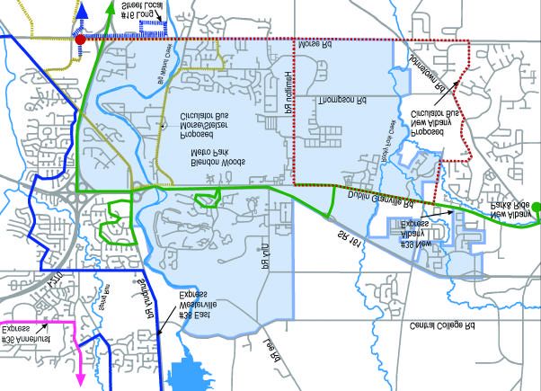
As indicated on the Public Transportation map (page 39), the Central Ohio Transit Authority (COTA) currently
provides limited bus service to the planning area. Local Routes originate or terminate in the downtown area and
have frequent stops and transfer points. Two local routes serving the area are the #16 Long Street and Easton
and the #95 Morse/Henderson Crosstown buses.
Express Routes originate or terminate in the downtown area and carry passengers to the suburban fringe areas
of Columbus, typically traveling at peak hours. There are two express bus routes that directly serve the planning
area; the #39 New Albany Express, and the #38 East Westerville Express, and two express bus routes that serve
the region adjacent to the planning area; the #36 Annehurst Express and the #37 Westerville Express The #39
(New Albany Express) serves portions of Dublin Granville Road, Little Turtle subdivision and Sunbury Road, with
a park and ride location in New Albany. I-270 and I-670 are used as the main thoroughfare to transport people
to and from downtown Columbus at limited peak hours only (morning and evening). The other Express bus
that serves the area is the #38 (East Westerville Express). This bus primarily travels between downtown and
portions of Sunbury Road and Morse Road, also operating at peak morning and evening hours only.
Residents in both the Blendon Woods and Chestnut Hills subdivisions, as well as those living and working along
Hamilton, Thompson, Cherry Bottom and Morse roads, do not currently receive convenient bus service.
COTA's Vision 2020 Long Range Plan recognizes the need for improved public transportation service in this
area. Specific expanded bus service and improvements anticipated for the planning area include:
w Increasing the frequency of service of the #39 New Albany Express.
w The completion of a transit center at Morse Road and Stelzer Road. This center will provide park and ride
options, as well as transfers between Local, Crosstown, Express and neighborhood circulator services,
plus daycare and other transit supportive amenities.
w Integrate the #39 New Albany Express routing into the Easton Transit Center.
w Expand the hours of operation of the #16 Long Street and Easton Local.
w Implement New Albany and Easton Link circulator bus services. These circulators would provide
a key linkage with the transit center and major activity centers and residential development in the
immediate vicinity.
w Extend the #89 Hamilton Crosstown, which currently stops at Broad Street, north to Morse Road then west
to Easton.
37The proposed neighborhood circulator buses would provide local neighborhood transportation options that are
transportation/public transportation
currently lacking for residents in the planning area.
The proposed route designations are:
Easton Link circulator:
This circulator would originate at the Easton Transit Center, with service along Morse Road, through the Blendon
Woods subdivision, to Blendon Woods Metro Park, along portions of Sunbury Road, and circulating the Easton
shopping complex. Specific service points would include the Northeast Career Center, Ross Labs, Blendon
Woods Metro Park, The Limited Headquarters and Easton.
New Albany circulator:
The New Albany circulator would originate at the proposed Morse-Stelzer Transit Center, and provide service
along Morse Road, Harlem Road, Rt. 62, Dublin-Granville Road, and Hamilton Road. Specific service points
would include The Limited Headquarters, New Albany and Easton.
Both circulators would provide citizens with the option of transferring to other buses at the proposed Morse-
Stelzer Transit Center. Maps of the three main routes in the planning area, as well as the proposed circulator
bus routes can be viewed on the Public Transportation map.
It is the recommendation of Northland Plan - Volume II that:
Ø the recommendations of the Vision 2020 Long Range Plan, especially those listed in the above text, be
implemented. Implementation is contingent upon receiving future funding.
Ø COTA investigate service options north of Morse Road, especially along Hamilton Road, to accommodate
the needs of the anticipated residential and commercial growth in the area.
Ø COTA continue to pursue the possibility of adding bike racks to the front of buses.
38public transportation
transportation /public transportation
Express Routes Proposed Circulator Park and Ride Location
Transit Center
Local Route
39pedestrian facilities
transportation/pedestrian facilities
Walking along collectors and arterials can be difficult for pedestrians. Major roadways in the planning area
are almost entirely without sidewalks. As roadway improvements are made, sidewalks should be installed.
Morse Road is currently being widened, and will include new sidewalks at proper setbacks. Sunbury Road is
scheduled for widening and city agencies are working together to ensure installation of a multi-use trail along
the east side right-of-way.
Most residential subdivisions in the planning area were developed with sidewalks, however the Gould Park
area north of Cherrybottom Park (South Park Drive and Wyandotte Drive) has none. Connectivity from the
Little Turtle area to Blendon Woods Metro Park, over the 161 expressway, is a community concern. Currently,
citizens have to walk or bike along the shoulder of Ulry Road or Little Turtle Way, both of which are heavily
traveled by motorists.
The consistent provisions of sidewalks and other types of pathways in the planning area, would allow better
connectivity between residents, places of business, points of recreation and public transportation. In 1999 the
city of Columbus adopted an ordinance requiring the installation of sidewalks whenever land is subdivided or
substantial property improvements are made (regardless of land use). The ordinance also expands the
definition of sidewalks to allow the selected use of materials other than concrete. The Columbus Recreation
and Parks Department is also planning a trail system along Big Walnut Creek, which would provide additional
pedestrian access in the planning area.
40You can also read