Notices to Mariners - Monthly Western Edition - Edition No. 09-2021 September 24, 2021 - Notices to Mariners (NOTMAR)
←
→
Page content transcription
If your browser does not render page correctly, please read the page content below
Notices to Mariners

                    Edition No. 09-2021
                      September 24, 2021

Monthly Western Edition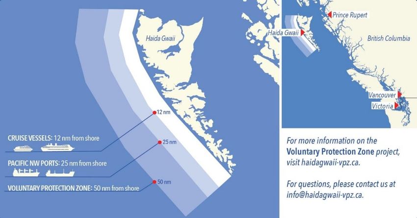
Notices to Mariners – Monthly Western Edition
Edition No. 09-2021
Aussi disponible en français :
Avis aux navigateurs – Édition mensuelle de l’Ouest
Édition n° 09-2021
Published under the Authority of:
Canadian Coast Guard Programs
Aids to Navigation and Waterways
Fisheries and Oceans Canada
Montreal, QC H2Y 2E7
For more information, contact Notmar.XNCR@dfo-mpo.gc.ca.
© Her Majesty the Queen in Right of Canada,
as represented by the Minister of Fisheries, Oceans
and the Canadian Coast Guard, 2021.
Cat. No. Fs152-6E-PDF (Electronic PDF, English)
ISSN 1719-7708
Cat. No. Fs152-6F-PDF (Electronic PDF, French)
ISSN 1719-7716
A web version is available here:
https://www.notmar.gc.ca/monthly-mensuel-en.php (English)
https://www.notmar.gc.ca/monthly-mensuel-fr.php (French)
Notices to Mariners – Monthly Western Edition
                                                          Explanatory Notes – Notices to Mariners (NOTMAR)

                     Explanatory Notes – Notices to Mariners (NOTMAR)
Geographical positions refer directly to the graduations of the largest scale Canadian Hydrographic
Service chart (unless otherwise indicated).

Bearings refer to the true compass and are measured clockwise from 000° (North) clockwise to 359°; those
relating to lights are from seaward.

Visibility of lights is that in clear weather.

Depths - The units used for soundings (metres, fathoms or feet) are stated in the title of each chart.

Elevations are normally given above Higher High Water, Large Tide (unless otherwise indicated).

Distances may be calculated as follows:
 1 nautical mile = 1,852 metres (6,076.1 feet)
 1 statute mile    = 1,609.3 metres (5,280 feet)
 1 metre           = 3.28 feet

Temporary and Preliminary Notices to Mariners – Section 1A of Notices to Mariners
These notices are indicated by a (T) or a (P), respectively. Please note that nautical charts are not amended
by the Canadian Hydrographic Service for temporary (T) and preliminary (P) notices. It is recommended that
mariners chart these corrections in pencil. For the list of charts affected by (T) & (P) notices, please refer to
the current Notices to Mariners - Monthly Summary of Temporary and Preliminary Notices publication.

Suggestions and Corrections Form
This form is specifically for suggestions and corrections to Notices to Mariners publications. It is available
online and also in fillable PDF format included with the monthly publication ZIP file.

To report chart discrepancies and/or corrections to the Sailing Directions booklets: Fill out the Marine
Information Reporting Form and/or email chsinfo@dfo-mpo.gc.ca.

To report emergencies or navigational hazards: Contact your nearest MCTS centre
 - VHF channel 16 (156.8 MHz)
 - MF/HF frequency 2182 kHz/4125 kHz (where available)
 - ∗16 on a cellphone (where available)

NOTMAR Website – Monthly Editions, Chart Corrections and Chart Patches
The NOTMAR website allows users to access the monthly publications, chart corrections, and chart patches.
Users can subscribe for free to the email notification service to receive notifications when charts of interest
are updated, including their patches, as well as when a new Monthly Edition of Notices to Mariners is
published.

In addition, the monthly publication and related files to download, such as chart patches and Sailing
Directions diagrams, can be obtained all together through the download of a single ZIP file.

Edition No. 09-2021 – 2021-09-24                                                                          Page i
Notices to Mariners – Monthly Western Edition
                                                   Explanatory Notes – Canadian Hydrographic Service (CHS)

              Explanatory Notes – Canadian Hydrographic Service (CHS)
Chart Corrections – Section 2 of Notices to Mariners
Corrections to nautical charts will be listed in numerical order by chart number. Each chart correction listed
applies only to that particular chart. Related charts, if any, will have their own specific correction listed
separately.

Users should also refer to CHS Chart 1: Symbols, Abbreviations and Terms for additional information
pertaining to the correction of charts.

The illustration below describes the elements that will comprise a typical Section 2 chart correction:

The last correction number is identified with the LNM/D or Last Notice to Mariners Number / Date.

Mariners are advised that only the most critical changes that directly affect safety to navigation are issued
in “Section 2 – Chart Corrections.” This limitation is required to ensure that charts remain as clear and easy
to read as possible. As a result, mariners may see minor discrepancies of a non-critical nature between
information in official publications. For example, a small change in the nominal range or focal height of a
light may not result in the production of a chart correction in Notices to Mariners, but may result in a correction
in the List of Lights, Buoys and Fog Signals publication.

Note: In the case of a discrepancy between information provided on CHS charts relating to aids to navigation,
and the List of Lights, Buoys and Fog Signals publication, the latter shall be deemed as containing the most
up-to-date information.

Canadian Nautical Charts & Publications
A source list of Canadian nautical charts and publications is published in Notice No. 14 of the Notices to
Mariners Annual Edition 2021. The source supply and the prices effective at the time of printing are listed.
For current chart edition dates, please refer to the following website: www.chs-shc.gc.ca/charts-
cartes/paper-papier/index-eng.asp.

Edition No. 09-2021 – 2021-09-24                                                                           Page ii
Notices to Mariners – Monthly Western Edition
Explanatory Notes – Marine Communications and Traffic Services (MCTS)
Explanatory Notes – Marine Communications and Traffic Services (MCTS)
Navigational Warnings / Notices to Shipping
The Canadian Coast Guard (CCG) is implementing a number of changes to the aids to navigation system
in Canada.
These changes are advertised as Navigational Warnings, formerly called Notices to Shipping1, that are
broadcast by the CCG, and are then followed up with Notices to Mariners, then charts are updated by hand
correction, reprints or new editions.
Mariners are advised that all relevant Navigational Warnings (NAVWARNs) should be kept until superseded
by Notices to Mariners or through revised charts issued by the Canadian Hydrographic Service (CHS).
NAVWARNs are accessible on the applicable regional page on the CCG Navigational Warnings website at
http://nis.ccg-gcc.gc.ca.
CHS is reviewing the impact of these changes with CCG and together are preparing an action plan on the
issuing of chart revisions.
For further information, contact your regional NAVWARN Issuing Desk.
Western Region Arctic Region
Prince Rupert MCTS Centre *Iqaluit MCTS Centre
Operational from approximately mid-May until
“P” Series NAVWARNs
late December.
Canadian Coast Guard
“A” and “H” Series NAVWARNs
Bag 4444
Prince Rupert, BC V8J 4K2 Canadian Coast Guard
P.O. Box 189
Telephone: 250-627-3070
Iqaluit, NU X0A 0H0
Email: NAVWARN.MCTSPrinceRupert@innav.gc.ca
“A” Series NAVWARNs
Telephone: 867-979-5269
“H” Series NAVWARNs
Telephone: 867-979-0310
Facsimile: 867-979-4264
Email: NAVWARN.MCTSIqaluit@innav.gc.ca
*Service available in English and in French.
1 The expression “Notice to Shipping” was changed to “Navigational Warning” in January 2019.
Edition No. 09-2021 – 2021-09-24 Page iiiNotices to Mariners – Monthly Western Edition
Table of Contents
Table of Contents
Section 1: General and Safety Information 1
Canadian Coast Guard Publication – Comments and Suggestions on Notices to Mariners (NOTMAR)
Publications ........................................................................................................................ 1
Transport Canada – COVID-19 Measures, Updates and Guidance ..................................................... 1
Canadian Hydrographic Service – Notices to Mariners for Changes in Buoy Shape ............................ 1
Anguniaqvia Niqiqyuam Marine Protected Area (ANMPA) And Tarium Niryutait Marine Protected
Areas (TNMPA) – Beluga And Bowhead Whale Protection: Voluntary Avoidance And
Slowdown Areas ................................................................................................................. 2
*901/21 Canadian Hydrographic Service – Electronic Navigational Charts....................................... 5
*902/21 Transport Canada – Ship Safety Bulletin #14/2021 ............................................................. 6
*903/21 West Coast Haida Gwaii – Voluntary Protection Zone for Shipping ..................................... 6
Section 1A: Te mporary and Preliminary Notices 8
Reminder – Comment Period for Active Preliminary Notices ............................................................... 8
Section 2: Chart Corrections 9
Section 3: Radio Aids to Marine Navigation Corrections 14
*909/21 Radio Aids to Marine Navigation 2021 (Atlantic, St. Lawrence, Great Lakes,
Lake Winnipeg, Arctic and Pacific).................................................................................... 14
Section 4: Sailing Dire ctions and Small Craft Guide Corrections 17
No corrections for this section. .......................................................................................................... 17
Section 5: List of Lights, Buoys and Fog Signals Corrections 18
Edition No. 09-2021 – 2021-09-24 Page ivNotices to Mariners – Monthly Western Edition
Numerical Index of Canadian Charts Affected
Numerical Index of Canadian Charts Affected
This numerical index lists all nautical charts mentioned in this monthly edition of Notices to Mariners. Only
charts appearing in Section 2 of this publication require a chart correction. The appearance of charts in all
other sections, particularly those related to the correction of other nautical publ ications, is included here for
reference.
Chart No. Pages Chart No. Pages Chart No. Pages
3056 8
3442 9
3443 9, 10
3490 10, 18
3491 10
3668 10, 11
3670 11, 12
3671 12, 13
Edition No. 09-2021 – 2021-09-24 Page vNotices to Mariners – Monthly Western Edition
Section 1: General and Safety Information
Section 1: General and Safety Information
Canadian Coast Guard Publication – Comments and Suggestions on Notices to Mariners
(NOTMAR) Publications
In an effort to continuously improve the Notices to Mariners publications and to provide the most efficient
service possible, the Notices to Mariners team invites all mariners and other interested parties to submit
comments and suggestions on possible improvements to its various publications and services at the
following email address: Notmar.XNCR@dfo-mpo.gc.ca.
Transport Canada – COVID-19 Measures, Updates and Guidance
(Recurrent publication of notice *401/20, originally published in the Notices to Mariners – Monthly Western Edition
04/2020 publication.)
Please refer to the link below for the latest updates to transportation related measures taken by Transport
Canada in response to the evolving novel Coronavirus disease (COVID-19):
https://www.tc.gc.ca/en/initiatives/covid-19-measures-updates-guidance-tc.html.
For travel advice and all other updates, please visit: Canada.ca/coronavirus.
Canadian Hydrographic Service – Notices to Mariners for Changes in Buoy Shape
(Recurrent publication of notice *906/20, originally published in the Notices to Mariners – Monthly Western Edition
09/2020 publication.)
As part of the CHS Digital Transformation and for the sake of economy, CHS will no longer systematically
issue Notices to Mariners (NTM) for buoy shape changes only. These changes will, however, be applied to
electronic navigation charts (ENCs) where applicable. The paper and raster versions will be updated during
the New Edition process.
Edition No. 09-2021 – 2021-09-24 Page 1Notices to Mariners – Monthly Western Edition
Section 1: General and Safety Information
Anguniaqvia Niqiqyuam Marine Protected Area (ANMPA) And Tarium Niryutait Marine
Protected Areas (TNMPA) – Beluga And Bowhead Whale Protection: Voluntary Avoidance
And Slowdown Areas
(Recurrent publication of notice *506/21, originally published in the Notices to Mariners – Monthly Western Edition
05/2021 publication.)
The two established Marine Protected Areas (MPAs) in Canada’s Wes tern Arctic are located within the
Inuvialuit Settlement Region, as such all activities must comply with the Inuvialuit Final Agreement .
Protection and preservation of Arctic wildlife, the environment and biological productivity is one of the
principles of the Inuvialuit Final Agreement and it is this principle that led the Inuvialuit Regional Corporation
and the Inuvialuit Game Council to initiate establishment of the Western Arctic MPAs. The waters in and
near the MPAs, and the offshore marine habitats of the Beaufort Sea and Amundsen Gulf, are important
summer foraging habitats used seasonally (May-October) by the Eastern Beaufort Sea beluga stock, and
the Bering-Chukchi-Beaufort bowhead population.
Regulatory Protection Measures
All whale species are protected under the Marine Mammal Regulations, pursuant to the Fisheries Act. Within
the boundaries of the MPAs, a general prohibition is set out in the Regulations, pursuant to the Oceans Act.
Any incident with a marine mammal within the MPAs must be reported within two hours after its occurrence,
to the Canadian Coast Guard. For marine wildlife sightings and incidents such as collisions that occur outside
the MPAs or for any situation involving a marine mammal that is dead or in trouble, contact Fisheries and
Oceans Canada, Inuvik office at (867) 777-7500.
Edition No. 09-2021 – 2021-09-24 Page 2Notices to Mariners – Monthly Western Edition
Section 1: General and Safety Information
For more information on the ANMPA and TNMPA, including local contacts and species specific minimum
distances, see Section A2 - Notices 5 and 5A.3 of the Notices to Mariners Annual Edition 2021.
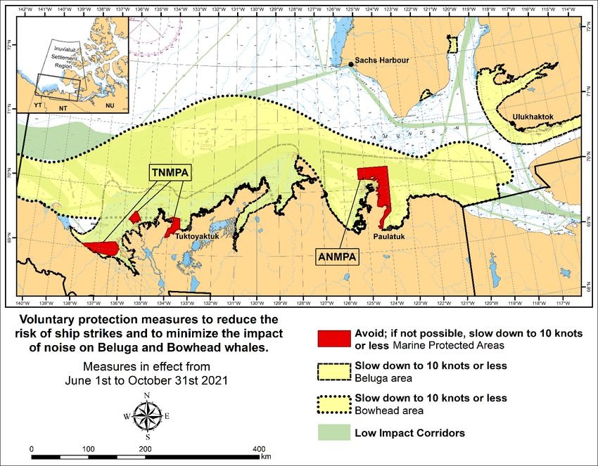
Voluntary Protection Measures
Voluntary measures are in effect from June 1st to October 31st , 2021. See map above.
These measures apply to merchant vessels, cruise ships, small vessels and adventure craft within the
boundaries of the MPAs and the additional identified areas to prevent collisions with whales and to mitigate
the underwater noise generated by the vessels. These measures should only be taken when they will not
jeopardize navigational safety.
Avoid (red area): To reduce the risk of underwater noise disturbance and collisions with whales within the
MPAs, vessels should avoid transiting through the MPAs if possible. If passage through this area is required,
vessels should slow down to a maximum speed through the water of 10 knots and post a lookout such as a
marine mammal observer in order to increase the chances of seeing the whales and thus taking necessary
measures to avoid them. If bypassing the whales is not possible, slow down and wait for the animals to move
away to a distance greater than 400 metres (0.215 nautical miles) before resuming original speed up to 10
knots. It is more difficult to see the animals in rain, fog, or in rough sea states, therefore increased caution
is recommended.
Slow down to 10 knots or less (yellow area): To reduce the risk of underwater noise disturbance and
collisions with whales within this area, it is recommended that vessels should slow down to a maximum
speed through the water of 10 knots, remain in the navigation and marked community supply channels and
post a lookout.
These voluntary measures are secondary to rights under the Inuvialuit Final Agreement.
MPA Coordinates
The Tarium Niryutait Marine Protected Areas consist of three areas of the Mackenzie Bay: Okeevik,
Kittigaryuit and Niaqunnaq. The three areas are bounded by rhumb lines connecting the following
geographical coordinates [North America Datum 1983 (NAD 83)/World Geodetic System (WGS 84)].
Edition No. 09-2021 – 2021-09-24 Page 3Notices to Mariners – Monthly Western Edition
Section 1: General and Safety Information
Okeevik Sub Area Kittigaryuit Sub Area
Point Latitude (North) Longitude (West) Point Latitude (North) Longitude (West)
1 69° 38’ 19” 135° 25’ 09” 1 69° 35’ 10” 133° 48’ 26”
2 69° 38’ 03” 135° 25’ 11” 2 69° 34’ 00” 133° 28’ 00”
3 69° 37’ 46” 135° 24’ 52” 3 69° 23’ 37” 133° 26’ 40”
4 69° 29’ 49” 135° 12’ 49” 4 69° 20’ 34” 133° 40’ 37”
5 69° 30’ 45” 135° 16’ 56” 5 69° 19’ 05” 133° 42’ 21”
6 69° 29’ 26” 135° 18’ 53” 6 69° 19’ 01” 133° 42’ 31”
7 69° 29’ 23” 135° 19’ 06” 7 69° 20’ 39” 133° 43’ 20”
8 69° 28’ 07” 135° 20’ 25” 8 69° 16’ 42” 133° 54’ 54”
9 69° 27’ 36” 135° 24’ 25” 9 69° 15’ 20” 134° 06’ 53”
10 69° 25' 51” 135° 32’ 27” 10 69° 16’ 33” 134° 05’ 56”
11 69° 26’ 32” 135° 34’ 54” 11 69° 20’ 42” 134° 02’ 44”
12 69° 28’ 21” 135° 35’ 24” 12 69° 24’ 00” 133° 59’ 10”
13 69° 28’ 35” 135° 36’ 40” 13 69° 24’ 34” 133° 53’ 49”
14 69° 28’ 39” 135° 37’ 58” 14 69° 28’ 21” 133° 48’ 15”
15 69° 30’ 34” 135° 45’ 54” 15 69° 28’ 02” 133° 50’ 59”
16 69° 35’ 18” 135° 35’ 42” 16 69° 33’ 20” 133° 47’ 29”
17 69° 36’ 00” 135° 22’ 10” 17 69° 34’ 33” 133° 47’ 42”
18 69° 34’ 40” 135° 20’ 09” 18 69° 32’ 55” 133° 51’ 09”
19 69° 34’ 00” 135° 20’ 09” 19 69° 32’ 56” 133° 51’ 54”
20 69° 34’ 00” 135° 27’ 39” 20 69° 33’ 46” 133° 55’ 48”
21 69° 36’ 00” 135° 27’ 39” 21 69° 33’ 46” 133° 55’ 31”
22 69° 27’ 00” 135° 31’ 11”
23 69° 27’ 00” 135° 34’ 45”
Niaqunnaq Sub Area
Point Latitude (North) Longitude (West)
1 69° 08’ 00” 136° 16’ 44”
2 69° 04’ 25” 136° 07’ 45”
3 69° 03’ 43” 136° 07’ 08”
4 69° 01’ 19” 136° 04’ 45”
5 69° 01’ 14” 136° 04’ 45”
6 69° 00’ 57” 136° 05’ 42”
7 69° 00’ 12” 136° 07’ 08”
8 68° 57’ 00” 136° 10’ 00”
9 68° 55’ 00” 136° 15’ 00”
10 68° 54’ 22” 136° 31’ 50”
11 68° 55’ 00” 136° 38’ 33”
12 68° 56’ 15” 137° 00’ 41”
13 68° 56’ 29” 137° 03’ 03”
14 68° 55’ 48” 137° 11’ 00”
15 68° 57’ 50” 137° 16’ 40”
16 68° 59’ 20” 137° 21’ 30”
17 69° 03’ 09” 137° 44’ 54”
Edition No. 09-2021 – 2021-09-24 Page 4Notices to Mariners – Monthly Western Edition
Section 1: General and Safety Information
The Anguniaqvia niqiqyuam Marine Protected Areas consist of two areas in Darnley Bay and Amundsen
Gulf in the Beaufort Sea: Zone 1 and Zone 2. The areas consist of the seabed, the subsoil to a depth of five
metres and the water column, including the sea ice. The two areas are bounded by straight lines c onnecting
the following geographical coordinates [North America Datum 1983 (NAD 83)].
Zone 1
Point Latitude (North) Longitude (West)
A 69° 21’ 07.8” 124° 21’ 32.0” approx
B 70° 12’ 00.0” approx 124° 31’ 55.2”
C 70° 08’ 22.0” 124° 41’ 45.0” approx
D 70° 09’ 09.9” 124° 57’ 42.0” approx
E 70° 09’ 13.0” approx 125° 05’ 28.6”
F 70° 09’ 13.2” 125° 17’ 53.0”
G 70° 20’ 00.0” 125° 17’ 53.0”
H 70° 20’ 00.0” 123° 54’ 17.5”
I 69° 37’ 20.6” 123° 54’ 17.5”
J 69° 30’ 00.0” 124° 15’ 34.7”
Zone 2
Point Latitude (North) Longitude (West)
K 70° 04’ 15.8” 124° 41’ 51.0” approx
L 70° 04’ 48.6” 124° 41’ 54.0” approx
M 70° 02’ 12.9” 124° 35’ 23.0” approx
N 70° 02’ 12.9” 124° 35’ 29.0” approx
*901/21 Canadian Hydrographic Service – Electronic Navigational Charts
ENC Compilation
S-57 ENC Number Chart Title Published
Scale
New Charts
CA373524 (Edn 1.000) Kuujjuarapik 1:37 500 2021-09-17
New Editions
CA470756 (Edn 3.000) Halibut Bank to/à Ballenas Channel 1:15 000 2021-09-17
CA473300 (Edn 8.000) Lac St-Louis au/to Lac St-Francois 1:12 500 2021-09-10
CA573386 (Edn 3.000) Baie Saint-François 1:6 000 2021-09-10
CA576124 (Edn 6.000) Port de Grave 1:2 500 2021-09-10
CA579157 (Edn 2.000) Carillon à/to L'Orignal 1:10 000 2021-09-24
Edition No. 09-2021 – 2021-09-24 Page 5Notices to Mariners – Monthly Western Edition
Section 1: General and Safety Information
*902/21 Transport Canada – Ship Safety Bulletin #14/2021
A new Ship Safety Bulletin has recently been posted on the Transport Canada website.
To view or download this bulletin, please click on the link below:
SSB#14/2021 – Update to the Small Vessel Compliance Program for Fishing Vessels not more than 15
Gross Tonnage
RDIMS#17825880
Sign up for e-Bulletin to receive an e-mail notice each time a new Ship Safety Bulletin is published on our
website.
Contact us at marinesafety-securitemaritime@tc.gc.ca or 1-855-859-3123 (Toll Free).
*903/21 West Coast Haida Gwaii – Voluntary Protection Zone for Shipping
Reference: Notice *803/21 is cancelled.
Please note that amendments to the original notice have been highlighted and deletions have been crossed out.
Trial Voluntary Protection Zone for Shipping, West Coast Haida Gwaii (formerly Queen Charlotte Islands)
Haida Gwaii’s remote location, rugged coastline, variable sea and weather conditions, and rich ecological
and cultural heritage make it vulnerable to the potential for pollution from s hipping breakdowns and
accidents. Increasing the distance vessels travel offshore can increase the amount of time available to
address propulsion, steering or other issues, and the likelihood of a towing vessel being able to respond to
a vessel that is disabled or drifting. This in turn reduces the risk of grounding and oil spills.
A trial Voluntary Protection Zone for Shipping on the West Coast of Haida Gwaii is currently in effect from
September 1, 2020 through October 31, 2021. In the Voluntary Protection Zone, commercial vessels of 500
gross tonnage or greater shall observe a minimum distance of 50 nautical miles offshore when transiting
along the West Coast of Haida Gwaii with the following exceptions:
– Cruise vessels, to observe a minimum 12 nm distanc e from shore;
– Vessels transiting between Pacific Northwest ports (Washington, Alaska, BC), to observe a minimum
25 nm distance from shore;
– Tugs and barges (including pushing and towing alongside), no minimum distance; and
– Fishing vessels, no minimum distance.
Edition No. 09-2021 – 2021-09-24 Page 6Notices to Mariners – Monthly Western Edition
Section 1: General and Safety Information
The Voluntary Protection Zone for Shipping coordinates are:
54⁰ 15.436' N 133⁰ 04.788' W
54⁰ 17.572' N 134⁰ 02.484' W
54⁰ 13.614' N 134⁰ 19.427' W
54⁰ 11.786' N 134⁰ 30.841' W
53⁰ 44.036' N 134⁰ 32.677' W
53⁰ 11.118' N 134⁰ 16.412' W
52⁰ 18.483' N 133⁰ 20.917' W
51⁰ 24.590' N 132⁰ 04.081' W
51⁰ 56.158' N 131⁰ 01.830' W
Vessels are requested to adhere to these distances on a voluntary basis and only when it does not jeopardiz e
the safety of navigation, the vessel, the persons aboard, and the cargo.
(NW-P-1085-20)
Edition No. 09-2021 – 2021-09-24 Page 7Notices to Mariners – Monthly Western Edition
Section 1A: Temporary and Preliminary Notices
Section 1A: Temporary and Preliminary Notices
Reminder – Comment Period for Active Preliminary Notices
This is a reminder that the comment period is still open for the following active Preliminary notices:
Reference Aids Affected
Notice # Intent of Notice
Chart # (LL #)
Pacific Coast
812(P)/21 3056 29.5, 30, 31 Aids to Navigation to be Discontinued
Please refer to the Notices to Mariners - Monthly Summary of Temporary and Preliminary Notices publication
for details.
Inland Waters
No notices applicable for this edition.
Pacific Coast
No notices applicable for this edition.
Edition No. 09-2021 – 2021-09-24 Page 8Notices to Mariners – Monthly Western Edition
Section 2: Chart Corrections
Section 2: Chart Corrections
3442 - North Pender Island to/à Thetis Island - New Edition - 01-JUL-2005 - NAD 1983
10-SEP-2021 LNM/D. 23-APR-2021
Add wreck WK with known depth of 51 metres 48°57′35.2″N 123°28′33.7″W
(See Chart No. 1, K26)
This notice affects Electronic Navigational Chart: CA470070
DFO(6204481-01)
Add wreck, least depth unknown 49°01′06.4″N 123°42′03.2″W
(See Chart No. 1, K29)
This notice affects Electronic Navigational Chart: CA470070
DFO(6204483-01)
Add rock awash at chart datum 49°01′17.6″N 123°42′08.1″W
(See Chart No. 1, K12)
This notice affects Electronic Navigational Chart: CA470070
DFO(6204483-02)
3443 - Thetis Island to/à Nanaimo - New Edition - 20-DEC-2002 - NAD 1983
10-SEP-2021 LNM/D. 19-MAR-2021
Add wreck WK with known depth of 51 metres 48°57′35.2″N 123°28′33.7″W
(See Chart No. 1, K26)
This notice affects Electronic Navigational Chart: CA470070
DFO(6204481-01)
Delete depth of 2.4 metres 49°05′16.1″N 123°47′24.6″W
(See Chart No. 1, I10)
This notice affects Electronic Navigational Chart: CA470070
DFO(6204482-01)
Add depth of 0.9 metres 49°05′17.0″N 123°47′25.2″W
(See Chart No. 1, I10)
This notice affects Electronic Navigational Chart: CA470070
DFO(6204482-02)
Add depth of 3.1 metres 49°02′59.5″N 123°45′08.4″W
(See Chart No. 1, I10)
This notice affects Electronic Navigational Chart: CA470070
DFO(6204482-03)
Add depth of 1.3 metres 49°04′53.0″N 123°47′01.4″W
(See Chart No. 1, I10)
This notice affects Electronic Navigational Chart: CA470070
DFO(6204482-04)
Delete depth of 3 metres 49°04′54.7″N 123°47′02.4″W
(See Chart No. 1, I10)
This notice affects Electronic Navigational Chart: CA470070
DFO(6204482-05)
Add wreck, least depth unknown 49°01′06.4″N 123°42′03.2″W
(See Chart No. 1, K29)
This notice affects Electronic Navigational Chart: CA470070
DFO(6204483-01)
Add rock awash at chart datum 49°01′17.6″N 123°42′08.1″W
(See Chart No. 1, K12)
This notice affects Electronic Navigational Chart: CA470070
DFO(6204483-02)
Edition No. 09-2021 – 2021-09-24 Page 9Notices to Mariners – Monthly Western Edition
Section 2: Chart Corrections
Add depth of 4.5 metres 49°03′21.7″N 123°43′09.9″W
(See Chart No. 1, I10)
This notice affects Electronic Navigational Chart: CA470070
DFO(6204484-01)
Add depth of 3.7 metres 49°03′11.5″N 123°42′40.1″W
(See Chart No. 1, I10)
This notice affects Electronic Navigational Chart: CA470070
DFO(6204484-02)
3490 - Fraser River/Fleuve Fraser, Sand Heads to/à Douglas Island, Compartment B-C - New Edition - 02-NOV-2012 -
World Geodetic System 1984
17-SEP-2021 LNM/D. 13-AUG-2021
Amend Q G to read Oc G 5s against the light 49°09′33.2″N 122°58′52.6″W
(See Chart No. 1, P1)
This notice affects Electronic Navigational Chart: CA570015
(P2021008) LL(355.9) DFO(6204463-01)
Amend Q Y 8m to read Oc Y 5s8m against the light 49°09′33.2″N 122°58′52.6″W
(See Chart No. 1, P1)
This notice affects Electronic Navigational Chart: CA570015
(P2021009) LL(356) DFO(6204464-01)
Amend Q Y 15m to read Oc (2) Y 5s15m against the light 49°09′36.0″N 122°58′39.8″W
(See Chart No. 1, P1)
This notice affects Electronic Navigational Chart: CA570015
(P2021010) LL(357) DFO(6204465-01)
3491 - Compartment B-C - New Edition - 19-OCT-2012 - World Geodetic System 1984
17-SEP-2021 LNM/D. 13-AUG-2021
Amend Q G to read Oc G 5s against the light 49°09′33.2″N 122°58′52.6″W
(See Chart No. 1, P1)
This notice affects Electronic Navigational Chart: CA570015
(P2021008) LL(355.9) DFO(6204463-01)
Amend Q Y 8m to read Oc Y 5s8m against the light 49°09′33.2″N 122°58′52.6″W
(See Chart No. 1, P1)
This notice affects Electronic Navigational Chart: CA570015
(P2021009) LL(356) DFO(6204464-01)
Amend Q Y 15m to read Oc (2) Y 5s15m against the light 49°09′36.0″N 122°58′39.8″W
(See Chart No. 1, P1)
This notice affects Electronic Navigational Chart: CA570015
(P2021010) LL(357) DFO(6204465-01)
3668 - Alberni Inlet - New Edition - 07-APR-2000 - NAD 1983
24-SEP-2021 LNM/D. 22-MAY-2020
Delete depth of 7.2 metres 48°52′58.0″N 125°07′20.0″W
(See Chart No. 1, I10)
This notice affects Electronic Navigational Chart: CA470167
DFO(6204487-02)
Add depth of 4.1 metres 48°56′01.5″N 125°06′03.6″W
(See Chart No. 1, I10)
This notice affects Electronic Navigational Chart: CA470167
DFO(6204487-04)
Edition No. 09-2021 – 2021-09-24 Page 10Notices to Mariners – Monthly Western Edition
Section 2: Chart Corrections
Add depth of 0.4 metres 48°52′58.8″N 125°07′22.5″W
(See Chart No. 1, I10)
This notice affects Electronic Navigational Chart: CA470167
DFO(6204487-05)
Add depth of 1.9 metres 48°56′00.4″N 125°06′15.9″W
(See Chart No. 1, I10)
This notice affects Electronic Navigational Chart: CA470167
DFO(6204487-06)
Add depth of 2.4 metres 48°55′48.7″N 125°06′10.3″W
(See Chart No. 1, I10)
This notice affects Electronic Navigational Chart: CA470167
DFO(6204487-07)
Add depth of 0.3 metres 48°52′21.6″N 125°09′46.4″W
(See Chart No. 1, I10)
This notice affects Electronic Navigational Chart: CA470167
DFO(6204487-08)
Add depth of 0.6 metres 48°55′14.2″N 125°01′17.9″W
(See Chart No. 1, I10)
This notice affects Electronic Navigational Chart: CA470167
DFO(6204487-09)
Add obstruction with known depth of 100 metres 49°09′15.7″N 124°48′11.0″W
(See Chart No. 1, K41)
This notice affects Electronic Navigational Chart: CA470167, CA570752
DFO(6204488-01)
Add submarine cable between 49°09′11.9″N 124°47′50.5″W
(See Chart No. 1, L30.1) and 49°09′15.7″N 124°48′11.0″W
This notice affects Electronic Navigational Chart: CA470167, CA570752, CA570753
DFO(6204488-02)
3670 - Broken Group - New Edition - 21-OCT-1994 - NAD 1983
24-SEP-2021 LNM/D. 26-MAR-2021
Delete depth of 2.6 metres 49°01′47.0″N 125°19′49.5″W
(See Chart No. 1, I10)
This notice affects Electronic Navigational Chart: CA470338, CA570335
DFO(6204485-01)
Add depth of 1.9 metres 49°01′47.3″N 125°19′50.2″W
(See Chart No. 1, I10)
This notice affects Electronic Navigational Chart: CA470338, CA570335
DFO(6204485-02)
Add depth of 4.4 metres 49°01′22.8″N 125°16′22.1″W
(See Chart No. 1, I10)
This notice affects Electronic Navigational Chart: CA470338, CA570335
DFO(6204485-03)
Delete depth of 1.8 metres 49°01′09.9″N 125°17′01.6″W
(See Chart No. 1, I10)
This notice affects Electronic Navigational Chart: CA570335
DFO(6204485-04)
Add depth of 0.9 metres 49°01′09.8″N 125°17′01.9″W
(See Chart No. 1, I10)
This notice affects Electronic Navigational Chart: CA570335
DFO(6204485-05)
Edition No. 09-2021 – 2021-09-24 Page 11Notices to Mariners – Monthly Western Edition
Section 2: Chart Corrections
Delete depth of 4.5 metres 49°01′14.0″N 125°17′05.8″W
(See Chart No. 1, I10)
This notice affects Electronic Navigational Chart: CA570335
DFO(6204485-06)
Add depth of 2.4 metres 49°01′14.1″N 125°17′05.9″W
(See Chart No. 1, I10)
This notice affects Electronic Navigational Chart: CA570335
DFO(6204485-07)
Add depth of 1.2 metres 49°01′39.5″N 125°18′50.0″W
(See Chart No. 1, I10)
This notice affects Electronic Navigational Chart: CA570335
DFO(6204485-09)
Add depth of 3.4 metres 49°01′02.3″N 125°18′08.5″W
(See Chart No. 1, I10)
This notice affects Electronic Navigational Chart: CA570335
DFO(6204485-10)
Add rock which covers and uncovers with drying height of 0.1 metres 49°01′38.4″N 125°15′17.0″W
(See Chart No. 1, K11)
This notice affects Electronic Navigational Chart: CA570335
DFO(6204485-11)
Add rock which covers and uncovers with drying height of 0.1 metres 49°01′34.6″N 125°15′22.1″W
(See Chart No. 1, K11)
This notice affects Electronic Navigational Chart: CA570335
DFO(6204485-12)
3671 - Barkley Sound - New Edition - 04-NOV-2005 - NAD 1983
24-SEP-2021 LNM/D. 16-APR-2021
Delete depth of 2.6 metres 49°01′47.0″N 125°19′49.7″W
(See Chart No. 1, I10)
This notice affects Electronic Navigational Chart: CA470338, CA570335
DFO(6204485-01)
Add depth of 1.9 metres 49°01′47.3″N 125°19′50.2″W
(See Chart No. 1, I10)
This notice affects Electronic Navigational Chart: CA470338, CA570335
DFO(6204485-02)
Add depth of 4.4 metres 49°01′22.8″N 125°16′22.1″W
(See Chart No. 1, I10)
This notice affects Electronic Navigational Chart: CA470338, CA570335
DFO(6204485-03)
Add rock which covers and uncovers with drying height of 0.2 metres 49°01′26.1″N 125°17′36.9″W
(See Chart No. 1, K11)
This notice affects Electronic Navigational Chart: CA470338
DFO(6204485-13)
Add rock which covers and uncovers with drying height of 0.6 metres 48°49′38.5″N 125°12′27.4″W
(See Chart No. 1, K11)
This notice affects Electronic Navigational Chart: CA470338
DFO(6204486-01)
Add depth of 1.2 metres 48°49′42.3″N 125°11′46.2″W
(See Chart No. 1, I10)
This notice affects Electronic Navigational Chart: CA470338
DFO(6204486-02)
Edition No. 09-2021 – 2021-09-24 Page 12Notices to Mariners – Monthly Western Edition
Section 2: Chart Corrections
Add depth of 1.4 metres 48°50′28.0″N 125°11′01.9″W
(See Chart No. 1, I10)
This notice affects Electronic Navigational Chart: CA470338
DFO(6204486-03)
Delete depth of 7.2 metres 48°52′58.0″N 125°07′20.0″W
(See Chart No. 1, I10)
This notice affects Electronic Navigational Chart: CA470167
DFO(6204487-02)
Add depth of 4.1 metres 48°56′01.5″N 125°06′03.6″W
(See Chart No. 1, I10)
This notice affects Electronic Navigational Chart: CA470167
DFO(6204487-04)
Add depth of 0.4 metres 48°52′58.8″N 125°07′22.5″W
(See Chart No. 1, I10)
This notice affects Electronic Navigational Chart: CA470167
DFO(6204487-05)
Add depth of 1.9 metres 48°56′00.4″N 125°06′15.9″W
(See Chart No. 1, I10)
This notice affects Electronic Navigational Chart: CA470167
DFO(6204487-06)
Add depth of 2.4 metres 48°55′48.7″N 125°06′10.3″W
(See Chart No. 1, I10)
This notice affects Electronic Navigational Chart: CA470167
DFO(6204487-07)
Add depth of 0.3 metres 48°52′21.6″N 125°09′46.4″W
(See Chart No. 1, I10)
This notice affects Electronic Navigational Chart: CA470167
DFO(6204487-08)
Add depth of 0.6 metres 48°55′14.2″N 125°01′17.9″W
(See Chart No. 1, I10)
This notice affects Electronic Navigational Chart: CA470167
DFO(6204487-09)
Edition No. 09-2021 – 2021-09-24 Page 13Notices to Mariners – Monthly Western Edition
Section 3: Radio Aids to Marine Navigation Corrections
Section 3: Radio Aids to Marine Navigation Corrections
*909/21 Radio Aids to Marine Navigation 2021 (Atlantic, St. Lawrence, Great Lakes,
Lake Winnipeg, Arctic and Pacific)
Page 2-61
AMEND AS FOLLOWS FOR SECTION 2.3:
Table 2-28 - Great Lakes (includes St. Lawrence River to Montréal)
Name
Class of
Coordinates Channel Remarks
Service
Call Sign
… … … …
Windsor, Ont. - 16 Operated by the Windsor Port Authority for ship traffic control only.
42°19'00"N 12 Vessels should make initial calls directly on Ch14.
083°04'00"W 14 Initial calls to the Harbour Authority should be made on Ch16.
XJP56
… … … …
Page 3-1
AMEND AS FOLLOWS FOR SECTION 3.1:
There is no intention on the part of the Canadian Coast Guard to attempt to navigate or manoeuvre
ships from a shore station and nothing in this publication overrides the authority of the master of his
their responsibility for the safe navigation of his their ship. Information passed to the master is
intended to assist him them in the safe conduct of his their ship.
Page 3-2
AMEND AS FOLLOWS FOR SECTION 3.3.1:
Where a ship, for any reason other than ship board radio equipment failure is unable to obtain the
required traffic clearance or after receiving a traffic clearance, is unable to maintain direct
communication with the appropriate MCTS Centre, the master may nevertheless proceed on his their
route, but shall take all reasonable measures to communicate with the appropriate MCTS Centre as
soon as possible and obtain the specified clearance.
Page 4-22
AMEND AS FOLLOWS FOR SECTION 4.2.2:
Master
(2) While a vessel is undergoing repairs, modifications or conversions in dry dock or in port or is laid
up, the vessel’s master may, on his or her their own initiative, and shall, if directed to do so by the
Minister,
a) reduce the frequency of the transmission of LRIT information to once every 24 hours; or
b) temporarily stop the transmission of LRIT information.
Edition No. 09-2021 – 2021-09-24 Page 14Notices to Mariners – Monthly Western Edition
Section 3: Radio Aids to Marine Navigation Corrections
Pages 4-37 to 4-38
AMEND AS FOLLOWS FOR SECTION 4.2.7.9:
Table 4-8 - Sailing Plan and Departure Report Example
EXAMPLE EXPLANATION
… Required
Z//EOR Z/EOR// …
Z //end of report. Z /end of report//
Optional
…
Table 4-9 - Final Arrival Report Example
EXAMPLE EXPLANATION
… Required
Z//EOR Z/EOR// …
Z //end of report. Z /end of report//
Optional
…
Table 4-10 - Position Report Example
EXAMPLE EXPLANATION
… Required
Z//EOR Z/EOR// …
Z //end of report. Z /end of report//
Optional
…
Table 4-11 - Deviation Report Used to Report Sailing Plan and Other Changes Example
EXAMPLE EXPLANATION
… Required
Z//EOR Z/EOR// …
Z //end of report. Z /end of report//
One or more of the following optional items
…
Edition No. 09-2021 – 2021-09-24 Page 15Notices to Mariners – Monthly Western Edition
Section 3: Radio Aids to Marine Navigation Corrections
Page 4-78
AMEND AS FOLLOWS FOR SECTION 4.3.11:
Non-Canadian ships (except Liberian ships) may obtain a cargo Ship Safety Radio Certificate
(GMDSS) in Canada. Applications should originate with the owners, ship agents or masters of the
ships concerned and be supported by confirmation from the Consul or other official representative of
the country in which the ship is registered. Confirmation shall be in writing. It is the responsibility of the
owner, agent or master to contact the Consul or official representative and arrange to submit the
necessary confirmation to the local Canadian Coast Guard inspection office. Where time is limited, a
verbal request for an inspection may be accepted from the Consul or official representative (a person
who has a document from an Administration giving him them the official power to act on their behalf),
provided that the confirmation is submitted later.
Edition No. 09-2021 – 2021-09-24 Page 16Notices to Mariners – Monthly Western Edition
Section 4: Sailing Directions and Small Craft Guide Corrections
Section 4: Sailing Directions and Small Craft Guide Corrections
No corrections for this section.
Edition No. 09-2021 – 2021-09-24 Page 17Notices to Mariners – Monthly Western Edition
Section 5: List of Lights, Buoys and Fog Signals Corrections
Section 5: List of Lights, Buoys and Fog Signals Corrections
The amendments are highlighted and deletions are crossed out. For general and region-specific information on the
List of Lights, click on the following links: Newfoundland and Labrador Coast, Atlantic Coast, Inland Waters and
Pacific Coast.
Focal
Position Description
Height Nomi- Remarks
----- Light -----
No. Name in m. nal -----
Latitude N. Characteristics Height in meters
above Range Fog Signals
Longitude W. above ground
water
PACIFIC COAST
FRASER RIVER (LL 310 – 371, 380.5 – 385)
355.9 Purf leet Point On W. extremity of Oc G 5s 7.6 7 Square skeleton tower on Flash 4.7 s; eclipse 0.3 s.
Annacis Island. 9-pile dolphin, light Y ear round.
49 09 33.2 mounted on the structure
122 58 52.6 of the f ront range. Chart:3490
Edn 09/21 (P21-008)
356 On W. extremity of Oc Y 5s 7.6 14 Square skeleton tower on Flash 4.7 s; eclipse 0.3 s.
G5413.32 Annacis Island. 9-pile dolphin, white Y ear round.
49 09 33.2 Q G 1s 7.8 4 day mark with red v ertical
Purf leet Point 122 58 52.6 stripe.
range
357 071°19’ 274.3 m Oc(2) Y 5s 15.2 14 Square skeleton tower on Flash 3.7 s; eclipse 0.3 s;
G5413.33 f rom f ront. 9 pile dolphin, white f lash 0.7 s; eclipse 0.3 s.
day mark with red v ertical Y ear round.
stripe.
Chart:3490
Edn 09/21 (P21-009, 010)
Edition No. 09-2021 – 2021-09-24 Page 18You can also read