Overview No. 66 - November 2021 - GEOGLAM Crop Monitor
←
→
Page content transcription
If your browser does not render page correctly, please read the page content below

No. 66 – November 2021                                        www.cropmonitor.org

                       Overview

Overview:
In East Africa, harvesting of main season cereals is underway in the north
with mixed conditions due to conflict impacts in parts of Ethiopia, South
Sudan, and Yemen and flooding in South Sudan and Sudan. There is also
concern for second season cereals across the south due to delayed onset
and dry conditions and forecast below-average rainfall for the coming
months. In West Africa, harvesting of main season cereals is underway
throughout the subregion, and conditions are generally favourable except
in regions impacted by persisting conflict and dry conditions. In the
Middle East and North Africa, early planting of winter wheat crops has
commenced under favourable conditions except in regions impacted by
conflict and socio-economic challenges. In Southern Africa, harvesting
of winter wheat crops is underway, and planting of main season cereals
has commenced under favourable conditions. In Central and South Asia,
planting of winter wheat crops has begun under mixed conditions due to
dry and hot conditions in parts of Afghanistan and Turkmenistan.
Harvesting of spring wheat crops finalized under mixed conditions due to
persistent dryness throughout the season. In northern Southeast Asia,
wet-season rice conditions have degraded in parts of Cambodia,
Myanmar, Thailand, and the Philippines due to heavy rainfall and flooding.
In Central America and the Caribbean, Segunda/Postrera season cereals
are developing under mixed conditions due to erratic and below-average
rains in parts of Guatemala and Honduras as well as localized flooding. In
Haiti, main and second season crops are unlikely to recover from
prevailing dryness.

                                                                             Contents:
                                                                             Conditions at a Glance…………………………………….……………..…......2
                                                                             Global Climate Outlook ……………..………………………………….….……3
                                                                             Climate Influences; Desert Locust Update ….………………………....4
                                                                             Seasonal Forecast Alert………………………………………………………..…5
                                                                             East Africa & Yemen; Regional Climate Outlook………………..…..6
                                                                             West Africa………………………………………….….….………..….……………10
                                                                             Middle East & North Africa; Regional Climate Outlook…..……11
                                                                             Southern Africa; Regional Climate Outlook……….………....……..13
                                                                             Central & South Asia; Seasonal Forecast Alert…….……….….…..15
                                                                             Southeast Asia…………………………………………………………………………...17
                                                                             Central America & Caribbean; Regional Climate Outlook…………..19
                                                                             Appendix – Terminology & Definitions……………….……….….....19

                                      The Crop Monitor is a part of GEOGLAM, a GEO global initiative.
2         No. 66 – November 2021                                                                     Crop Monitor for Early Warning

GEOGLAM Crop Monitor for Early Warning
                                            Crop Conditions at a Glance
                      based on best available information as of October 28th

Crop condition map synthesizing information for all Crop Monitor for Early Warning crops as of October 28th. Crop conditions over the main growing
areas are based on a combination of inputs including remotely sensed data, ground observations, field reports, national, and regional experts. Regions
that are in other than favourable conditions are labeled on the map with a symbol representing the crop(s) affected.

EAST AFRICA: Harvesting of main season cereals is underway in                main season cereals has begun, and conditions are favourable
the north with mixed conditions in Ethiopia due to ongoing                   despite delayed rainfall onset in parts of Angola. Forecasts of
conflict in Tigray and poor conditions in South Sudan and Yemen              average to above-average seasonal rainfall from December is
due to impacts from flooding, conflict, and socio-economic                   likely to benefit yields (See Regional Outlook Pg. 14).
challenges. In the south, planting and development of second                 CENTRAL & SOUTH ASIA: Planting of winter wheat crops has
season cereals is underway with concern due to a delayed rainfall            begun under mixed conditions as dry and hot conditions may
onset and dry conditions, and below-average rainfall is forecast             impact crop development in parts of Afghanistan and
for the October to December period (See Seasonal Forecast Alert              southeastern Turkmenistan. Harvesting of spring wheat crops
Pg. 5 and Regional Outlook Pg. 9).                                           finalized under mixed conditions as persistent dryness
WEST AFRICA: Harvesting of main season maize crops is                        throughout the season resulted in below-average yields.
wrapping up in the south while harvesting of main season cereals             SOUTHEAST ASIA: In the north, conditions for wet-season rice
is underway in the north, and conditions are generally favourable            have degraded in parts of Cambodia, Myanmar, Thailand, and
except in parts of Mali, Niger, Burkina Faso, and Cameroon                   the Philippines due to the effects of heavy rainfall and flooding
impacted by dry conditions and in regions impacted by                        from late September. In Indonesia, harvesting of dry-season rice
persisting conflict.                                                         is underway while planting of wet-season rice has begun, and
MIDDLE EAST & NORTH AFRICA: Early planting of winter wheat                   overall conditions are favourable.
crops has commenced under generally favourable conditions                    CENTRAL AMERICA & CARIBBEAN: In Central America,
except in conflict affected regions of Syria and Libya. Also,                Segunda/Postrera season cereals are developing under mixed
forecast drier than average conditions are likely for much of the            conditions due to erratic and below-average rains in parts of
Middle East (See Regional Outlook Pg. 11).                                   Guatemala and southern Honduras. In the Caribbean, harvesting
SOUTHERN AFRICA: Harvesting of winter wheat crops is                         of both main and second season cereals is underway, and crops
underway, and overall conditions are favourable. Planting of                 in Haiti are unlikely to recover due to prevailing dryness.

                                              The Crop Monitor for Early Warning is a part of GEOGLAM,
                                                    a GEO global initiative. www.cropmonitor.org
3        No. 66 – November 2021                                                                             Early Warning Crop Monitor

Global Climate Outlook: 30-day Forecast of Areas with Above or Below -Average Precipitation
The 30-day precipitation forecast indicates a likelihood of above-average rainfall over the northeast of the United States, central
and northern Brazil, western Ecuador, central Peru, central Bolivia, western Paraguay, northern and western Argentina, Wales,
northeastern France, Portugal, southern India, northern Myanmar, southern China, northern Japan, Indonesia, and northern and
eastern Australia.
There is also a likelihood of below-average rainfall in the Dominican Republic, southern Brazil, eastern Paraguay, Uruguay, southern
Chile, southern Ethiopia, Somalia, Kenya, southern Democratic Republic of Congo, Burundi, Tanzania, eastern Angola, Zambia,
Mozambique, northeastern Zimbabwe, Madagascar, and northern Philippines.

Figure 1. Forecast of areas with above or below-average precipitation over the next 30-days starting on October 28th 2021. The image is the multimodel
mean of precipitations anomaly from the Subseasonal Experiment (SubX) model forecasts for that day. The anomaly is based on the 1999 to 2016
model average. Skill assessments of SubX can be accessed here. Source: UCSB Climate Hazards Center

                                                The Crop Monitor for Early Warning is a part of GEOGLAM,
                                                    a GEO global initiative. www.cropmonitor.org
4       No. 66 – November 2021                                                                              Crop Monitor for Early Warning

Climate Influences: La Niña event present and expected to continue                                                                             during
November to January, and negative IOD event currently underway
The El Niño-Southern Oscillation (ENSO) is currently in the La Niña phase with NOAA CPC/IRI issuing a La Niña Advisory in
October. La Niña conditions are expected to continue during November to January (93% chance) and into April (63% chance for
February-March-April). Climate forecasts also anticipate exceptionally warm west Pacific Ocean conditions, which can amplify the
impact of cool eastern Pacific La Niña conditions.
La Niña conditions typically increase the chances of below-average precipitation in East Africa, Central and South Asia, southern
South America, the southern United States, northern Mexico, and eastern East Asia. There are elevated risks of a two-year
sequence of dry conditions in these regions, associated with La Niña conditions last year and this year. La Niña conditions typically
increase the chances of above-average precipitation in parts of Southeast Asia, Australia, Southern Africa, and northern South
America.
The Indian Ocean Dipole (IOD) is in a negative state. Most models forecast a return to neutral by December. Negative IOD
conditions typically increase the chances of above-average precipitation in Southeast Asia and Australia and below-average
precipitation in East Africa.
Source: UCSB Climate Hazards Center

Figure 1. Timing of wet and dry conditions related to La Nina https://fews.net/la-ni%C3%B1a-and-precipitation. Source: NOAA & CHC & FEWS NET

Desert Locust Update: Breeding may occur in parts of Ethiopia, Somalia , and Eritrea
with the onset of OND rains
In Ethiopia, a few summer-bred swarms likely formed in Afar, southeastern Tigray, and eastern Amhara regions. Swarms are
expected to migrate to the Red Sea coast of Eritrea and to eastern Ethiopia and northern Somalia. In Somalia, a few mature
spring-bred swarms are present in the northeast, though no swarms have been reported recently in the northwest. In Sudan,
minimal scattered adults are present in the interior, and a few groups are forming in northern Khartoum. In Yemen, a few summer-
bred swarms are likely present in the interior. A few swarms will likely migrate from the interior to the coasts for winter breeding.
With the onset of the October to December rainfall period, breeding is likely to occur in parts of eastern Ethiopia, north and
northwestern Somalia, and coastal Eritrea.

                                                  The Crop Monitor for Early Warning is a part of GEOGLAM,
                                                      a GEO global initiative. www.cropmonitor.org
5       No. 66 – November 2021                                                                    Crop Monitor for Early Warning

Seasonal Forecast Alert: Third consecutive poor rainfall season emerging for OND
2021, and fourth consecutive season likely for MAM 2022
A third consecutive poor rainfall season is emerging in eastern East Africa (See Regional Outlook Pg. 9), and there is also concern
for a likely fourth poor rainfall season in March-April-May (MAM) 2022. The October-November-December (OND) 2021 season
rainfall performance in eastern areas is, thus far, consistent with the elevated risk of below-normal rainfall during La Niña and
negative Indian Ocean Dipole conditions and with ICPAC and climate model rainfall forecasts in advance of this season.
Concerns for poor MAM 2022 rainfall performance are founded upon the in-progress La Niña event, the forecast Pacific Ocean sea
surface temperature (SST) configuration for MAM 2022, and below-normal MAM rainfall during many similar years. For MAM 2022,
NMME models confidently predict much warmer-than-average SSTs across the western Pacific Ocean and cooler-than-average
SSTs in the equatorial eastern Pacific Ocean (Figure 1-left). This forecast indicates that a strong “Western V” tropical-extratropical
gradient (WVG) could help produce La Niña-like suppressed rainfall impacts in the eastern Horn during MAM, even if eastern Pacific
SST are not cool enough to meet La Niña criteria in MAM. There is a ~90% chance of strong MAM WVG conditions. Five-month
lead NMME forecasts for WVG conditions during MAM are skillful (Figure 1-right), due to the models’ ability to forecast La Niña-
related SST variations and the strong warming trend in the western Pacific. In years when climate models forecast a strong negative
WVG, as they do for MAM 2022 (red circle), many MAM seasons had below-normal rainfall (orange circles show all below-normal
seasons).
Climate models do not provide reliable long-range rainfall predictions for the MAM season. Using recent historical analogs as a
guide, based on similar La Niña and WVG climate conditions, the chance for below-normal rainfall in MAM 2022 is higher than
50% in many areas of the eastern Horn. Back-to-back dry OND and MAM seasons emerged under similar conditions last year, and
predictions of those dry seasons were accurate. Given the high likelihood of a poor OND 2021 season, and the anticipated MAM
2022 Pacific Ocean conditions, it is likely that the eastern East Africa region will experience four sequential dry seasons.

Figure 1. Indications for a likely below-normal MAM 2022 season. Left— Map showing October NMME model mean forecast sea surface temperatures
for March-April-May (MAM) 2022, presented as standardized anomalies (Z-scores) to illustrate the historical forecast extremity of warm Western V-
region SST (three connected western Pacific yellow boxes) and Nino 3.4 region SST (eastern yellow box). NMME models used are: CanCM4i, COLA-
RSMAS-CCSM4, GEM-NEMO, NASA-GEOSS2S, and NCEP-CFSv2. SST is standardized using a 1982-2021 baseline. Right— Scatterplot of predicted and
observed MAM Western V Gradient (WVG) values. The “Western V gradient” is the difference between standardized NINO3.4 and Western V time
series. Forecasts based on October NMME predictions. There is a 90% chance of strong Pacific Ocean sea surface temperature WVG gradient conditions
during MAM 2022. The red circle shows the 2022 forecast. All below-normal eastern East African MAM rainy seasons are noted with orange circles.
When strong negative WVG values have occurred or been predicted, below-normal MAM rains have been likely. More details are provided in a Climate
Hazards Center Blog (http://blog.chc.ucsb.edu/?p=1030). Source: Climate Hazards Center

                                              The Crop Monitor for Early Warning is a part of GEOGLAM,
                                                  a GEO global initiative. www.cropmonitor.org
6          No. 66 – November 2021                                                                     Crop Monitor for Early Warning

East Africa & Yemen

Crop condition map synthesizing Maize 1 crop conditions as of October 28th. Crop conditions over the main growing areas are based on a combination
of inputs including remotely sensed data, ground observations, field reports, national, and regional experts. Conditions that are other than favourable
are labeled on the map with their driver.

In the north of the subregion, harvesting of June to September
main season cereals is underway in Ethiopia, South Sudan,
and Yemen while crops continue to develop in Djibouti,
Eritrea, and Sudan for harvest from November. In Ethiopia,
conditions are mixed for Meher season crops due to ongoing
conflict in the north. Additionally, below-average yields are
expected in South Sudan and Yemen due to impacts from
flooding, conflict, and socio-economic challenges, and there is
some concern in localized areas of eastern Sudan due to
flooding. Elsewhere, conditions are generally favourable.
In the south of the subregion, harvesting of main season
cereals is wrapping up in northern Uganda and the main
producing regions in Kenya, and crops in Karamoja region in
Uganda have failed due to flooding in May followed by
persistent dryness throughout the season. Planting and
development of second season cereals is underway across
Uganda, Rwanda, Somalia, the United Republic of Tanzania,
Burundi, and Kenya, and conditions are mixed as dry                    For detailed description of the pie chart please see description box on Pg. 21.

conditions and a delayed start to the rainfall season are
causing concern in parts of Somalia, the United Republic of Tanzania, Kenya, and Uganda. Across many parts of the subregion,
including eastern Kenya, southern Somalia, and Belg-receiving regions in Ethiopia, two consecutive poor rainy seasons have resulted
in below-average crop production and deteriorated food security situations. Dry conditions are forecast to continue through late
November, particularly in parts of Kenya, Uganda, southern Somalia, southern Ethiopia and South Sudan. Additionally, there are
increased chances of a fourth below-average rainy season during March to May 2022 in eastern Ethiopia, Kenya, and Somalia (See
Seasonal Forecast Alert Pg. 5 and Regional Outlook Pg. 9). While the desert locust situation is not currently impacting cropping areas
significantly, seasonal rains may promote breeding and egg laying (See Desert Locust Alert Pg. 4).

                                                 The Crop Monitor for Early Warning is a part of GEOGLAM,
                                                     a GEO global initiative. www.cropmonitor.org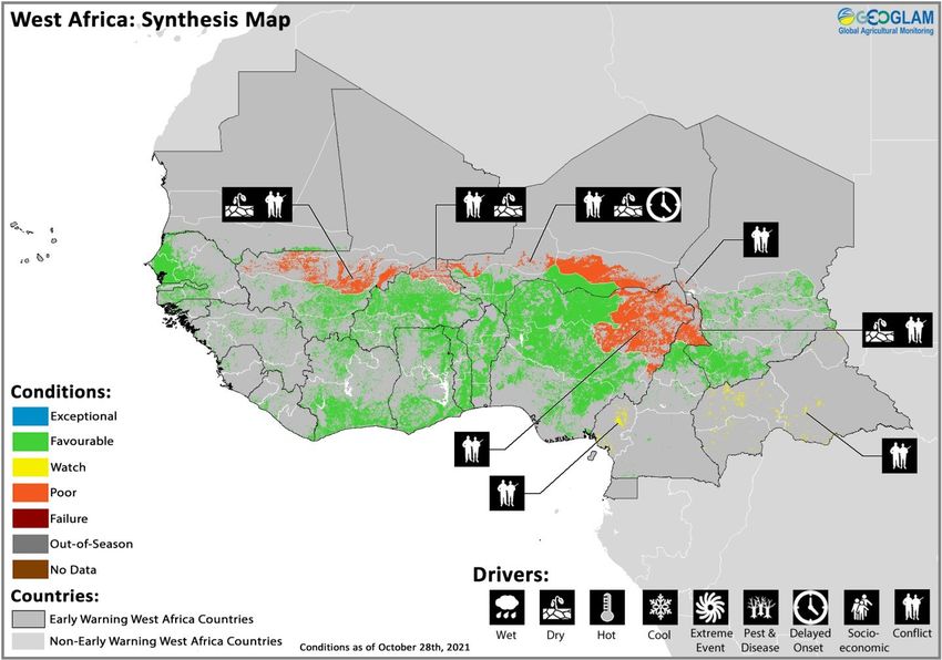
7         No. 66 – November 2021                                                                     Crop Monitor for Early Warning

                                                                                                  Northern East Africa & Yemen

                                                                                               In Ethiopia, harvesting of Meher season (Long
                                                                                               Rains) cereals is underway, and conditions are
                                                                                               mixed due to ongoing conflict and socio-
                                                                                               economic challenges in Tigray that have since
                                                                                               extended to neighbouring parts of Afar and
                                                                                               East and West Amhara. The conflict in Tigray
                                                                                               has resulted in displacement, livelihood
                                                                                               disruption, and increased food insecurity. Only
                                                                                               370,000 hectares of land have been planted as
                                                                                               of late October, a 47 percent decline compared
                                                                                               to the previous year due in part to a lack of fuel
                                                                                               and cash for transportation of agricultural
                                                                                               inputs. In Amhara, agricultural support facilities
                                                                                               have been damaged and looted due to conflict.
                                                                                               Elsewhere, conditions remain generally
                                                                                               favourable for ongoing harvesting activities;
                                                                                               however, there are pockets of dry spells and
 Crop condition map synthesizing Sorghum 1 conditions as of October 28th. Crop conditions over below-average rains in East Oromia, and
 the main growing areas are based on a combination of inputs including remotely sensed data,
                                                                                               localized flooding has reduced harvests in parts
 ground observations, field reports, national, and regional experts. Conditions that are other
                                                                                               of Gambela. In South Somali region, planting of
 than favourable are labeled on the map with their driver.
                                                                                               main season sorghum and teff crops is
underway with concern due to current dry conditions that are forecast to continue through November (See Regional Outlook Pg. 9).
In Sudan, main season millet and sorghum crops are in vegetative to reproductive stage for harvest from November, and conditions
are generally favourable except in the east where previous flooding may impact final yields. While some crops may recover, crop
damage was extensive, and soils remain saturated. Land preparation is underway for winter wheat crops, and planting will begin in
November. In South Sudan, harvesting of first season cereals is underway, and below-average yields are expected due to the impacts
of conflict and socio-economic challenges, widespread flooding since the beginning of the season, and dry conditions in parts of
Kapoeta during the early stages of growth which were followed by heavy rains near maturation and harvesting. Since May, more than
700,000 people have been affected by widespread flooding, with Jonglei and Unity states being the worst affected. Rains are expected
to continue in eastern parts of the country for the remainder of the year. For some areas, this is the third consecutive year of flooding,
and this year is compounding impacts from previous years. Conversely, second season maize and sorghum crops are in vegetative
to reproductive stage, and there is concern as parts of the south are experiencing some rainfall deficits. While there could be time for
some crop recovery if November rainfall improves, precipitation is likely to remain below-average (See Regional Outlook Pg. 9). In
Djibouti, main season millet and sorghum crops are in vegetative to reproductive stage for harvest from November, and conditions
are favourable. In Eritrea, main season sorghum and winter wheat crops continue to develop under favourable conditions for harvest
from November. In Yemen, harvesting of main season sorghum crops is nearing completion, and conditions are poor due to persistent
socio-economic challenges and conflict.
                                                                                                   Southern East Africa
                                                                                                   In Karamoja region in Uganda, harvesting of
                                                                                                   first season maize is nearing completion, and
                                                                                                   crops have failed due to episodes of flooding
                                                                                                   followed by extreme dry conditions. Erratic
                                                                                                   rains in March delayed planting activities of
                                                                                                   first season cereals and negatively impacted
                                                                                                   crop germination. This was followed by
                                                                                                   flooding in May and then below-average and
                                                                                                   erratic rainfall for much of the cropping
                                                                                                   season which significantly impacted yields.
                                                                                                   Rainfall improvements from mid-September
                                                                                                   eased dry conditions; however, heavy rainfall
                                                                                                   also resulted in severe floods, waterlogging,
                                                                                                   and crop damage in Napak District of
                                                                                                   Karamoja region. Throughout the country,
                                                                                                   second season maize crops are developing
                                                                                                   under generally favourable conditions except
Crop condition map synthesizing Maize 2 conditions as of October 28th. Crop conditions over the    in some northern areas where below-average
main growing areas are based on a combination of inputs including remotely sensed data, ground     rains and poor soil moisture remain a
observations, field reports, national, and regional experts. Conditions that are other than        concern. Conversely, in eastern parts of the
favourable are labeled on the map with their driver.                                               country, landslides, hailstorms, and heavy
                                               The Crop Monitor for Early Warning is a part of GEOGLAM,
                                                   a GEO global initiative. www.cropmonitor.org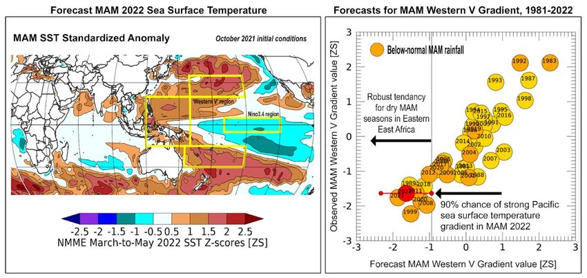
8        No. 66 – November 2021                                                                Crop Monitor for Early Warning

winds resulted in localized crop destruction in some districts. Rainfall through December is likely to be below-average in the southern
half of the country (See Seasonal Forecast Alert Pg. 5 and Regional Outlook Pg. 9). In Kenya, harvesting of 2021 Long Rains cereals is
underway in major producing unimodal rainfall areas of the West and Rift Valley, and overall conditions remain favourable as average
to above-average cumulative rainfall has generally benefitted crop development. However, erratic rainfall in these areas from March
to May resulted in replanting and some crop damage. Despite improved precipitation from July to September, national maize
production is forecast to be eight percent below-average due to earlier dry spells, though yields remain near-average. Planting of
Short Rains maize crops is underway, and there is concern due to dry conditions and poor rainfall forecasted for the October to
December Short Rains which could result in a third consecutive poor rainy season in the north and eastern areas (See Seasonal
Forecast Alert Pg. 5 and Regional Outlook Pg. 9). In Somalia, planting of Deyr season maize and sorghum crops is underway with
concern due to continued dry conditions. Rains have so far been minimal to absent throughout most parts of the country, and below-
average rainfall is forecast to continue through the end of the year and through early 2022 (See Seasonal Forecast Alert Pg. 5 and
Regional Outlook Pg. 9). In Burundi, planting of second Season A maize crops began in October under favourable conditions, and
harvesting will take place from January. In Rwanda, planting of second Season A maize crops continued in October under generally
favourable conditions, though some concern remains due to below-average rains in October which are forecast to continue through
November (See Regional Outlook Pg. 9). In the United Republic of Tanzania, planting of Vuli season maize and Masika season wheat
is underway in northern bimodal rainfall areas, and concern remains as delayed rainfall onset and dry conditions may impact crop
development with up to 50 percent rainfall deficits in some areas. Land preparation is underway for Msimu season cereals in unimodal
and major producing regions of the central, southwest, and southeast, and planting will begin in November.

                                           The Crop Monitor for Early Warning is a part of GEOGLAM,
                                               a GEO global initiative. www.cropmonitor.org
9       No. 66 – November 2021                                                                         Crop Monitor for Early Warning

Regional Outlook: Poor start to the OND rainfall season , and increased chances of
below-average rainfall to continue through January 2022
Rainfall deficits in October have led to a very poor start to the October-November-December (OND) 2021 rainfall season, and as
we approach the midpoint of the season in many eastern areas, rainfall forecasts continue to be pessimistic. The increasing
likelihood for a below-normal OND 2021 season in these areas is highly concerning, given that a series of poor rainfall seasons
recently impacted the eastern Horn. There are also elevated chances of a fourth poor rainfall season in March-April-May 2022 (See
Seasonal Forecast Alert Pg. 5).
Many areas, including southeastern Ethiopia, southern and central Somalia, central and eastern Kenya, and northeastern Tanzania
received less-than 60% of average rainfall for October 1st through October 25th (Figure 1-top left). In Somalia, some areas received
only a small fraction of typical amounts. In Ethiopia, prevailing average to above-average conditions from recent months continued
into October, exceeding 150% of average in some central, western, and northern areas. In the central Oromia region, rainfall since
March was historically low and erratic, though rainfall in late September to early October somewhat improved seasonal totals.
                                                                                            Poor October-to-date rainfall performance will
                                                                                            likely continue or worsen in many areas (Figure 1-
                                                                                            top right). If pessimistic forecasts materialize,
                                                                                            rainfall amounts from October through mid-
                                                                                            November may be the lowest in the past 40 years.
                                                                                            The two-week forecast indicates below-average
                                                                                            rainfall in southern Somalia, southern Ethiopia,
                                                                                            Kenya, Uganda, and Tanzania through November
                                                                                            10th. During November 13th to the 26th, most
                                                                                            SubX models predict increased chances of below-
                                                                                            normal rainfall across the region (Figure 1-bottom
                                                                                            left). These latest dry forecasts are highly
                                                                                            concerning. In southeastern Ethiopia and southern
                                                                                            Somalia, seasonal rains typically peak in October to
                                                                                            early November, so the observations and forecasts
                                                                                            indicate a poor season overall. In Kenya, the
                                                                                            majority of OND season rains are usually received
                                                                                            by the 2nd or 3rd week of November. In areas of
                                                                                            central-eastern Kenya, OND rains contribute more
                                                                                            than half the annual rainfall total.
                                                                                            Longer-range models predict increased chances
                                                                                            for     drier-than-normal      conditions     during
                                                                                            November-December-January            in    Ethiopia,
                                                                                            northern and eastern Kenya, and Somalia (Figure 1-
                                                                                            bottom right). Models have lower agreement
                                                                                            elsewhere in the region. Temperatures are likely to
                                                                                            be warmer-than-normal across most areas of the
                                                                                            region, particularly in central and eastern Kenya,
                                                                                            southern Somalia, and eastern Tanzania (not
                                                                                            shown). Dry conditions often result from negative
                                                                                            Indian Ocean Dipole and La Niña-like conditions,
                                                                                            which have been present recently.

Figure 1. October-to-present rainfall anomaly, October-to-November 10th rainfall anomaly outlook, a 2-week rainfall forecast probability, and a 3-
month rainfall forecast probability. The top two panels are CHC Early Estimates, which compare 2021 rainfall amounts to the 1981-2020 CHIRPS
average. On the upper left is the rainfall anomaly for October 1st to 25th, expressed as a percent of average. The upper right panel indicates what the
post-October 1st rainfall percent of average would be if the 15-day unbiased GEFS forecast from October 26th materializes. The bottom left panel
shows the IRI SubX Precipitation Biweekly Probability Forecast for November 13th to 26th, issued on October 29th. The forecast is based on statistically-
calibrated tercile category forecasts from three SubX models. Image from the IRI Subseasonal Forecasts Maproom. The bottom right panel is a
probabilistic forecast for most-likely November-December-January 2021-22 rainfall tercile from the WMO Lead Centre for Long-Range Forecast Multi-
Model Ensemble, based on October conditions. White color indicates that there is no dominant category across the model forecasts. Source: UCSB
Climate Hazards Center

                                                The Crop Monitor for Early Warning is a part of GEOGLAM,
                                                    a GEO global initiative. www.cropmonitor.org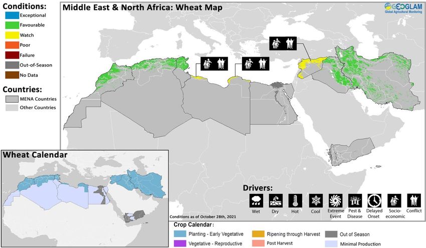
10        No. 66 – November 2021                                                                     Crop Monitor for Early Warning

West Africa

Crop condition map synthesizing information as of October 28th. Crop conditions over the main growing areas are based on a combination of inputs
including remotely sensed data, ground observations, field reports, national, and regional experts. Crops that are in other than favourable conditions
are labeled on the map with their driver.

In the south of the subregion, harvesting of main season maize finalized in northern Ghana, northern Togo, northern Benin, and the
Far North region in Cameroon while harvest continues in central Cameroon, southwestern Chad, and the Central African Republic.
Harvesting of main season sorghum crops finalized in the Far North region of Cameroon and continues in Cote d’Ivoire, northern
Ghana, Togo, Benin, central Cameroon, and southern Chad. Harvesting of second season cereals is underway in central Cameroon
and northern Nigeria while crops continue to develop in Cote d’Ivoire, southern Ghana, southern Togo, southern Benin, and
southern Nigeria. In the north of the subregion, harvesting of main season cereals is nearing completion in Niger and is underway
in Guinea-Bissau, Guinea, Mali, Mauritania, Senegal, Gambia, and Burkina Faso. Throughout the subregion, conditions are
generally favourable except in parts of northern Burkina Faso, central Mali, Niger, and the Far North region of Cameroon where dry
conditions have further contributed to decreased yields and where conflict continues to disrupt agricultural activities. In these areas
of Burkina Faso, Mali, and Niger, severe to very severe rainfall deficits in September were coupled with long dry spells of more than
14 days during the critical flowering to maturation stage of crop growth. In the Far North of Cameroon, rainfall deficits were
categorized as slight to moderate with maximum dry spell periods of 14 days. Additionally, conflict continues to disrupt agricultural
activities and result in below-average yields in the Southwest region of Cameroon, Lac region in Chad, the Central African Republic,
and northeastern Nigeria. In Burkina Faso, generally favourable weather conditions since the beginning of the cropping season have
benefitted planting and crop germination. The timely onset of seasonal rains in April was followed by well distributed and average to
above-average precipitation through late September in most cropping areas. However, below-average July and August rainfall in
parts of northwest and northern areas likely impacted local yields. While government support to access subsidized agricultural inputs
increased plantings in main producing south and central regions, increased insecurity in the northeast has limited access to agricultural
inputs and labour and led to field abandonment, particularly in the Sahel, Centre‑Nord, Nord, and Est regions. Despite reduced cereal
production prospects in the northeast, aggregate production is expected to be above-average due to favourable conditions in the
south and centre. In Mali, adequate seasonal rainfall was conducive for crop development of coarse grains in the major growing
regions in the south and west, supporting plantings and yields. However, adverse weather, reduced access to inputs, and a
deterioration of the security situation in parts of important rice producing central and northern regions resulted in a significant
contraction of plantings, and production of rice is expected at reduced levels. In the Central African Republic, weather conditions
are overall favourable, though persisting conflict and displacements continue to impact agricultural activities and limit access to
growing areas and inputs, with a likely negative impact on 2021 production. However, a ceasefire declaration by the president in

                                                The Crop Monitor for Early Warning is a part of GEOGLAM,
                                                    a GEO global initiative. www.cropmonitor.org
11 No. 66 – November 2021 Crop Monitor for Early Warning
October could initiate a lessening of conflict. In Benin, heavy rains and the release of water from the Nagbeto dam in September
and October resulted in flooding, causing localized agricultural losses. Reports from the country indicate disruption to agricultural
activities due to widespread flooding in several municipalities in the south and northeast. However, at the aggregate level, cereal
production in the country is expected at average levels.
Middle East & North Africa
Crop condition map synthesizing wheat conditions as of October 28th. Crop conditions over the main growing areas are based on a combination of inputs
including remotely sensed data, ground observations, field reports, national, and regional experts. Crops that are in other than favourable conditions
are labeled on the map with their driver.
In the Middle East and North Africa, planting of winter wheat crops is starting in Algeria, Iran, Iraq, Libya, Morocco, Syria, and
Tunisia, though the majority of planting will take place from November. While planting conditions are favourable, ongoing conflict
and socio-economic challenges continue to impact agricultural activities throughout Syria and Libya. Additionally, winter season
rainfall has been below-average in Tunisia and the eastern half of Algeria, and there are increased probabilities of drier than average
conditions for much of the Middle East for the November to January period in accordance with the forecast La Niña event (See
Regional Outlook Pg. 12). In Egypt, harvesting of summer planted rice and main season maize crops is wrapping up while Nili season
(Nile Flood) rice crops continue to develop, and overall conditions are favourable. Land preparation is underway for winter wheat
crops, and planting will begin in November.
The Crop Monitor for Early Warning is a part of GEOGLAM,
a GEO global initiative. www.cropmonitor.org12 No. 66 – November 2021 Crop Monitor for Early Warning
Regional Outlook: Below-normal rainfall likely for many areas through February
and above-normal temperatures through November
For many areas of the region, there are
increased chances of below-normal rainfall
during November to February. According to
the WMO forecast from October (Figure 1-
top), this outcome is most likely to occur in
the eastern Mediterranean and in eastern
and western Iran. Models indicate that
seasonal temperatures are likely to be
warmer-than-normal in the western
Mediterranean and in North Africa.
During November, conditions are likely to
be warmer than normal and with atypically
high daytime maximum temperatures,
particularly in the Middle East (Figure 1-
bottom). SubX 30-day forecasts also
indicate mainly average rainfall, with
increased chances for below-average rains
in northern Morocco and in portions of the
Middle East.
Figure 1. A 4-month rainfall forecast probability, and a 1-month temperature max (Tmax) anomaly forecast. The top panel is a probabilistic forecast
for most-likely November-December-January-February 2021-22 rainfall tercile from the WMO Lead Centre for Long-Range Forecast Multi-Model
Ensemble, based on October conditions. White color indicates that there is no dominant category across the model forecasts. The bottom panel is a
SubX multi-model forecast for the average maximum temperature over the 30-day period beginning on October 28th, as compared to historical
forecasts. Image from UCSB CHC Experimental Subseasonal Forecasts webpage. Source: UCSB Climate Hazards Center
The Crop Monitor for Early Warning is a part of GEOGLAM,
a GEO global initiative. www.cropmonitor.org13 No. 66 – November 2021 Crop Monitor for Early Warning
Southern Africa
Crop condition map synthesizing wheat conditions as of October 28th. Crop conditions over the main growing areas are based on a combination of inputs
including remotely sensed data, ground observations, field reports, national, and regional experts. Crops that are in other than favourable conditions
are labeled on the map with their driver.
In Southern Africa, harvesting of winter wheat crops is underway in Zimbabwe, Lesotho, South Africa, and Zambia under generally
favourable conditions. In Lesotho, near-average yields are expected despite the estimated reduction in planted area. Despite power
cuts across Zimbabwe earlier in the season, a bumper crop is expected due to an expansion in planted area as well as increased
government support to farmers. In South Africa, recent rains have improved soil moisture, particularly in the minor producing Eastern
Cape where crop conditions have improved, and above-normal rainfall from the previous summer season is supporting irrigation
water availability. In the major producing Western Cape, normal to above-normal rainfall during the winter season is supporting
production, and conditions are exceptional.
Planting of main season cereals is underway across the region and will start in full in November, with crops to be harvested from
February 2022, and overall conditions are favourable. However, parts of Angola have experienced rainfall delays up to two dekads,
and forecasts indicate western areas may experience a second consecutive below-average rainfall season (See Regional Outlook Pg.
14). Also, forecasts indicate drier than normal conditions may be expected in Zambia, eastern Angola, Zimbabwe, and portions of
Mozambique and Madagascar in the first two dekads of November, though rainfall improvements will likely emerge in central to
southeastern areas of the subregion from December (See Regional Outlook Pg. 14). In the Democratic Republic of Congo, harvesting
of mains season cereals is underway in the north and west while planting and development continues elsewhere under favourable
conditions. In central regions, near-average precipitation has resulted in slight improvements to vegetation conditions despite uneven
distribution. In Malawi, a timely onset of seasonal rains has been observed during October, leading to average to above-average soil
moisture levels across the country. Planting operations are expected to begin as normal, and forecasts of average to above-average
rainfall are likely to lead to favourable production.
The Crop Monitor for Early Warning is a part of GEOGLAM,
a GEO global initiative. www.cropmonitor.org14 No. 66 – November 2021 Crop Monitor for Early Warning
Regional Outlook: Elevated chances of above-normal DJF rainfall in central to
southeastern areas and below-average rainfall in western Angola
Between October 1st and October 25th, below-average rainfall was received in central and southern Madagascar, southern
Mozambique, eastern South Africa, and portions of western Angola (Figure 1-left). Aside from in South Africa, these deficits are
occurring prior to the critical rainfall period for crop development, which begins in November or December.
Drier-than-average conditions are likely during early-to-mid November in Zambia, eastern Angola, Zimbabwe, and portions of
Mozambique and Madagascar (Figure 1-middle). Over the 30-day period from October 28th, SubX models forecast rainfall deficits
to be around 25 to 50 mm in affected areas (See Global Climate Outlook Pg. 3)—amounts that could potentially limit early season
planting. Warmer-than-average November temperatures are likely in many of these areas. ECMWF extended range forecasts show
increased chances of wet conditions in northeastern Madagascar and northeastern Mozambique during late October to early
November, and in-mid-to-late November in southern Botswana and central South Africa (not shown).
Some long-range model forecasts indicate elevated chances for above-normal December-January-February rainfall in some central
to southeastern areas, including in Zimbabwe, Botswana, South Africa, and southern Mozambique (Figure 1-right). This is
consistent with a historical tendency for La Niña-like conditions to enhance rainfall in this part of the region. La Niña conditions
recently developed and are forecast to continue into early 2022. Last year during similar climate conditions, many of these areas
experienced above-average rainfall, and some experienced damages from severe weather and flooding.
Western areas of Angola may experience a below-average rainfall season, based on indications from some models in the NMME,
C3S, and WMO forecasts for the November-to-March period. In southwestern Angola, extremely dry conditions prevailed during
the 2020-2021 season.
Figure 1. October-to-present rainfall anomaly, a 2-week rainfall probability forecast, and a 3-month rainfall probability forecast. The left panel is a
CHC Early Estimate, which compares October 01-25 2021 rainfall amounts to the 1981-2020 CHIRPS average. The middle panel shows the IRI SubX
Precipitation Biweekly Probability Forecast for November 6th to 19th, issued on October 29th. The forecast is based on statistically-calibrated tercile
category forecasts from three SubX models. Image from the IRI Subseasonal Forecasts Maproom. The right panel shows the NMME probabilistic forecast
for December-January-February (OND) 2021 precipitation, based on October initial conditions. Colors indicate the dominant tercile category forecast
across models; white indicates no dominant category. NMME image from NOAA CPC. Source: UCSB Climate Hazards Center
The Crop Monitor for Early Warning is a part of GEOGLAM,
a GEO global initiative. www.cropmonitor.org15 No. 66 – November 2021 Crop Monitor for Early Warning
Central & South Asia
Crop condition map synthesizing Winter Wheat conditions as of October 28th. Crop conditions over the main growing areas are based on a combination
of inputs including remotely sensed data, ground observations, field reports, national, and regional experts. Crops that are in other than favourable
conditions are labeled on the map with their driver.
In Central and South Asia, planting of winter wheat crops is underway in southern Kazakhstan, Kyrgyzstan, Tajikistan, Afghanistan,
Pakistan, Turkmenistan, and Uzbekistan under mixed conditions. Throughout Afghanistan and in southeastern Turkmenistan,
there is concern as dry and hot conditions may impact crop development. Also, the lack of monetary fluidity in Afghanistan is
preventing many farmers from accessing quality seeds for planting, which could have significant implications for final yields. In
northern Kyrgyzstan, planting conditions are favourable despite lack of precipitation in the last six months and reduced irrigation
water, leading to low soil moisture levels. Elsewhere, planting conditions are favourable; however, increased precipitation will be
needed in Kyrgyzstan, southern Kazakhstan, southwestern Tajikistan, and Uzbekistan for crop germination and establishment. In
Pakistan, planting activities have begun under generally favourable weather conditions, and irrigation water supplies and agricultural
inputs are reportedly adequate. Planted area is forecast to surpass last year’s above-average level, supported by high wheat flour (the
main staple) prices. Additionally, harvesting of Kharif (summer) season rice crops began under favourable conditions, and harvesting
will finalize in January.
Harvesting of spring wheat crops
finalized in Kazakhstan, Kyrgyzstan,
Tajikistan, and Mongolia under mixed
conditions. In Kazakhstan and northern
Kyrgyzstan, dry conditions throughout
the season resulted in below-average
yields. In northern Kyrgyzstan,
cumulative rainfall levels were 70
percent below-average in the main
producing Chuy province, which is
responsible for about 50 percent of
aggregate wheat output. Additionally,
there has been a lack of irrigation water
throughout the season as a result of the
protracted 2020/2021 winter which
resulted in late melting of snowpack. As
Crop condition map synthesizing Spring Wheat conditions as of October 28 . Crop conditions over the a result, low soil moisture levels are
th
main growing areas are based on a combination of inputs including remotely sensed data, ground expected to have a negative impact on
observations, field reports, national, and regional experts. Conditions that are other than favourable crop yields. In Mongolia, the 2021 wheat
are labeled on the map with their driver. output is estimated at around 500,000
tonnes, reflecting an increase in the area planted. Yields are expected to be near-average despite delays in rains at the start of the
season and above-average rains that delayed harvesting in some areas.
The Crop Monitor for Early Warning is a part of GEOGLAM,
a GEO global initiative. www.cropmonitor.org16 No. 66 – November 2021 Crop Monitor for Early Warning
Seasonal Forecast Alert: Second consecutive season of below-average precipitation
likely to continue through early 2022
There is an increased risk of another season of below-
average precipitation in Central and Southwest Asia
during the Northern Hemisphere fall and winter of
2021-2022, according to multiple forecasting centers.
This is consistent with the typical drying impacts of La
Niña conditions, which are likely to continue through
early 2022. According to the WMO forecast for
November-to-February (Figure 1), the chances for
below-normal precipitation are elevated across the
region and are greater-than 50% in central and
northern Afghanistan, southern Turkmenistan,
southern Uzbekistan, and southern Tajikistan. During
the next 30 days, SubX forecasts indicate atypically
high daytime maximum temperatures in northeastern
areas, while some southern areas may be cooler than
normal. Below-average precipitation is forecast in
western Kyrgyzstan, Tajikistan, eastern Afghanistan,
and northern Pakistan.
The possibility of below-normal precipitation during
the upcoming season is highly concerning, especially
Figure 1. Forecast for 2021-2022 precipitation. WMO probabilistic forecast for given that October-to-May precipitation totals were
November-to-February 2021-2022 precipitation, based on models initialized in very low last year. Dry weather conditions during the
October. From WMO Lead Centre Long-Range Forecast Multi-Model Ensemble. 2020-2021 winter wheat and spring wheat-growing
Source: Climate Hazards Center seasons led to water deficits during key months of
crop development and resulted in poor and failed
crop conditions for winter wheat across parts of the
region. Poor or mediocre early to mid-season
precipitation performance this year could produce
lasting negative impacts on crops, limited irrigation,
and low snowpack and reservoir levels and could also
prolong recovery from 2020-2021 drought impacts in
affected areas of the region.
The Crop Monitor for Early Warning is a part of GEOGLAM,
a GEO global initiative. www.cropmonitor.org17 No. 66 – November 2021 Crop Monitor for Early Warning
Southeast Asia
Crop condition map synthesizing rice conditions as of October 28th. Crop conditions over the main growing areas are based on a combination of inputs
including remotely sensed data, ground observations, field reports, national, and regional experts. Crops that are in other than favourable conditions
are labeled on the map with their driver.
In northern Southeast Asia, wet-season rice is in grain filling to harvesting stage under mixed conditions. From late September to
early October, the effects of developed tropical cyclones resulted in heavy rainfall and flood damage during the grain filling stage in
large areas throughout Cambodia, Myanmar, Thailand, and the Philippines. While crop yields harvested prior to the heavy
precipitation are expected to be near-average, final projection levels may be reduced due to flood damage. In Indonesia, harvesting
of dry-season rice is continuing under favourable conditions with
yields slightly higher than the previous year due to sufficient
precipitation. Sowing of wet-season rice is beginning under
favourable conditions, albeit slightly behind last year’s pace. In
the Philippines, wet-season rice sown in July and August is in
heading to flowering stage under mixed conditions due to
moderate to heavy rainfall from an enhanced Southwest
monsoon that impacted most parts of Luzon and Western Visayas
from September to the second week of October. Near to above-
normal rainfall is expected for most parts of the country through
the end of October. In Thailand, wet-season rice is in the grain
filling stage under mixed conditions as a result of excess rainfall
and widespread flooding from tropical cyclone Dianmu. Rice field
damage is estimated to be 400,000 hectares and 4 percent of the
total planted area, which could result in production declines. In
northern Viet Nam, wet-season rice is in grain filling stage and is
beginning to harvest in some provinces under favourable
conditions. Yield is estimated to be the same as last year at 5.3
tons per hectare. In the South, harvesting of summer-autumn For detailed description of the pie chart please see description box on Pg. 21.
(main wet-season) rice is wrapping up with yields slightly higher
The Crop Monitor for Early Warning is a part of GEOGLAM,
a GEO global initiative. www.cropmonitor.org18 No. 66 – November 2021 Crop Monitor for Early Warning
than the previous year at 5.65 tons per hectare due to sufficient rainfall received. Autumn-winter (wet-season) rice is in young panicle
forming to harvesting stage also with increased yields expected compared to the previous year. In Laos, wet-season rice is in grain
filling to early harvesting stage under favourable conditions. In lowland areas, planted area has reached 101 percent of the national
plan, and 11 percent of the planted area has been harvested. Some areas in the North were affected by heavy rain in early October,
but damaged area has not yet been reported. In upland areas, 23 percent of the planted area has been harvested, and final production
is estimated to be higher than the national production plan. In Myanmar, planting of wet-season rice is now complete, and planted
area has reached 98.6 percent of the national plan. Crops are mostly in tillering to panicle forming stage, and conditions are generally
favourable except in areas impacted by recent flooding. In October, heavy rainfall and monsoon flooding occurred in most areas,
particularly in the Delta, affecting 23,000 hectares of wet-season rice and damaging 12,000 hectares. In Cambodia, planted area of
wet-season rice has reached 110 percent of the national plan, and crops are developing under mixed conditions due to recent heavy
rainfall. In late September, the Northern region and lowland area of the Mekong basin were impacted by heavy rainfall and flooding.
Close to 1.8 percent of the cultivated area was affected, and yield is estimated to decrease slightly. Around 57 percent of the cultivated
area of early planted crops has been harvested, and yield is expected to be near-average at around 4 tons per hectare. In Sri Lanka,
harvesting of Yala season rice and maize crops finalized with near-average yields expected. Planting of Maha season maize and rice
crops commenced under favourable conditions for harvest from February 2022. In Bangladesh, Aman season rice crops are in
vegetative to reproductive stage under favourable conditions, and harvesting activities will begin in mid-November. In Nepal, main
season rice crops are in vegetative to reproductive stage under favourable conditions, and harvesting activities will begin in November.
In the Democratic People’s Republic of Korea, harvesting of main season rice crops finalized in October under favourable conditions
with above-average biomass throughout the season. However, a short period of below-average rains in the first two dekads of July
over most parts of the country as well as floods in the east in early August have resulted in localized crop losses.
The Crop Monitor for Early Warning is a part of GEOGLAM,
a GEO global initiative. www.cropmonitor.org19 No. 66 – November 2021 Crop Monitor for Early Warning
Central America & Caribbean
Crop condition map synthesizing Postrera season conditions as of October 28th. Crop conditions over the main growing areas are based on a combination
of inputs including remotely sensed data, ground observations, field reports, national, and regional experts. Conditions that are other than favourable
are labeled on the map with their driver.
In Central America, Segunda/Postrera season cereals are in
vegetative to reproductive stage for harvest from December,
and overall conditions are mixed. In parts of Guatemala and
southern Honduras, Postrera season bean crops are unlikely
to recover from highly erratic and below-average rains.
Medium and subsistence farmers have reported losses of
beans between 50 and 80 percent, and large producers have
also reported yield reductions. Additionally, there is concern
for Segunda season maize crops in southern Guatemala and
southern Honduras as erratic rainfall distribution has
affected production areas with both dry spells and flooding,
and yield reductions are likely. Bean crops have generally
fared worse than maize crops in these areas of Guatemala
and Honduras due to differences in the start of the season
and length of the growing season. Conversely, conditions
remain favourable in El Salvador, northern Guatemala,
northern Honduras, and Nicaragua. Forecasts indicate
drier-than-normal conditions may continue in Haiti, central-
For detailed description of the pie chart please see description box on Pg. 21
southern Honduras, and northeastern Nicaragua through
November (See Regional Outlook Pg. 20).
In Guatemala, reduced precipitation amounts from late September have resulted in reduced soil moisture levels and below-average
crop conditions. Additionally, below-average precipitation amounts are forecast to continue in the northeast for the remainder of the
year with a likely negative effect on crop yields (See Regional Outlook Pg. 20). In El Salvador, planted area of the minor Segunda
season maize crop is expected to be above-average, supported by high prices and good soil moisture and despite localized flooding.
In Honduras, harvesting of rice crops is underway and will finalize in November, and production is expected to be average. While
rainfall was well below-average at planting between May and mid-June, replanting occurred in localized areas of the main producing
central-east region. In mid-June, improved precipitation benefitted soil moisture and crop development.
The Crop Monitor for Early Warning is a part of GEOGLAM,
a GEO global initiative. www.cropmonitor.org20 No. 66 – November 2021 Crop Monitor for Early Warning
In the Caribbean, harvesting of both main
and second season cereals is underway in
Cuba and Haiti, and overall conditions are
mixed due to prevailing dryness in Haiti. In
Haiti, harvesting of main season rice crops
finalized under poor conditions as erratic and
below-average rainfall did not supply
sufficient irrigation water, and production is
expected to remain below-average.
Additionally, below-average yields are also
likely for second season maize and bean
crops as erratic and deficient rainfall has
affected many cropping areas and resulted in
yield reductions. Below-average precipitation
between late August and early October has
resulted in below-average cumulative rainfall
amounts despite improvements in mid-
October, resulting in soil moisture deficits
and yield declines. In Cuba, harvesting of
main season maize and second season rice
Crop condition map synthesizing Segunda season conditions as of October 28th. Crop conditions crops is underway, and despite generally
over the main growing areas are based on a combination of inputs including remotely sensed data,
below-average precipitation in September
ground observations, field reports, national, and regional experts. Conditions that are other than
through mid-October, especially in both tips
favourable are labeled on the map with their driver.
of the island, crop conditions are favourable
with near-average yields expected.
Regional Outlook: Dry conditions are forecast to continue in parts of Guatemala,
Honduras, and Nicaragua through early November
Seasonal rainfall deficits are forecast to strengthen in central and northern Guatemala, central and eastern Honduras, and central
and eastern Nicaragua during late October to early November. Figure 1-left shows rainfall amounts for August 1st to November
10th, including the two-week GEFS forecast from October 26th. During the forecast period, there are increased chances for above-
average rainfall in portions of northern Honduras, Costa Rica, and Panama. Central and northern Guatemala have had below-
average and erratic rainfall during the season and in recent weeks.
The probabilistic SubX forecast for November 13th to November 26th (Figure 1-right) indicates that drier-than-normal conditions
may continue in Haiti, central-southern Honduras, and northeastern Nicaragua. This forecast would suggest a dry end to Haiti’s
poorly performing season. The next 30 days are forecast to be warmer than normal, with atypically high daytime maximum
temperatures in Guatemala, Honduras, El Salvador, southern Belize, and northern Haiti.
Figure 1. August-to-November 10th rainfall anomaly outlook, and a 2-week rainfall forecast probability. The left panel is a CHC Early Estimate, which
compares 2021 rainfall amounts to the 1981-2020 CHIRPS average. It indicates what the post-August 1st rainfall percent of average would be if the
15-day unbiased GEFS forecast from October 26th materializes. The right panel shows the IRI SubX Precipitation Biweekly Probability Forecast for
November 13th to 26th, issued on October 29th. The forecast is based on statistically-calibrated tercile category forecasts from three SubX models.
Image from the IRI Subseasonal Forecasts Maproom. Source: UCSB Climate Hazards Center
The Crop Monitor for Early Warning is a part of GEOGLAM,
a GEO global initiative. www.cropmonitor.orgYou can also read