Overview of National Hurricane Center/ Tropical Analysis and Forecast Branch (TAFB) Marine Products and Services - WMO Region IV Hurricane ...
←
→
Page content transcription
If your browser does not render page correctly, please read the page content below
Overview of National Hurricane Center/
 Tropical Analysis and Forecast Branch
 (TAFB) Marine Products and Services
   WMO Region IV Hurricane Workshop
           April 26th, 2021

             Chris Landsea
        Chris.Landsea@noaa.gov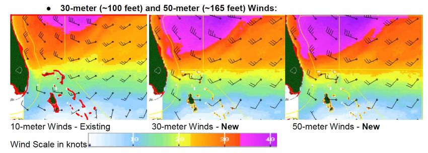
Overview of National Hurricane Center/
   Tropical Analysis and Forecast Branch
   (TAFB) Marine Products and Services

 To provide meteorological analysis, forecasts and
warnings over the tropical and subtropical oceans for
         the protection of life and property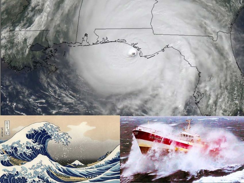
A Bad Cruise

               3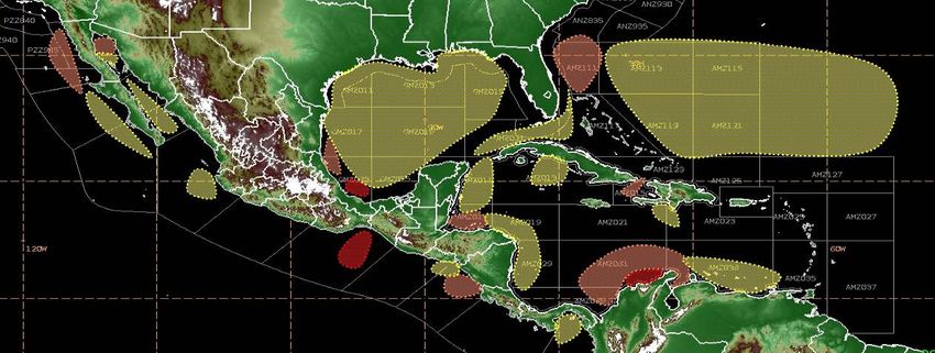
Global High Seas Forecasts
- International Maritime Organization
NHC/TAFB - Areas of Responsibility

  Ocean
Prediction                       Ocean
  Center                       Prediction
                                 Center

Honolulu
             NHC / TAFB
                              NHC /
Forecast
 Office
                              TAFB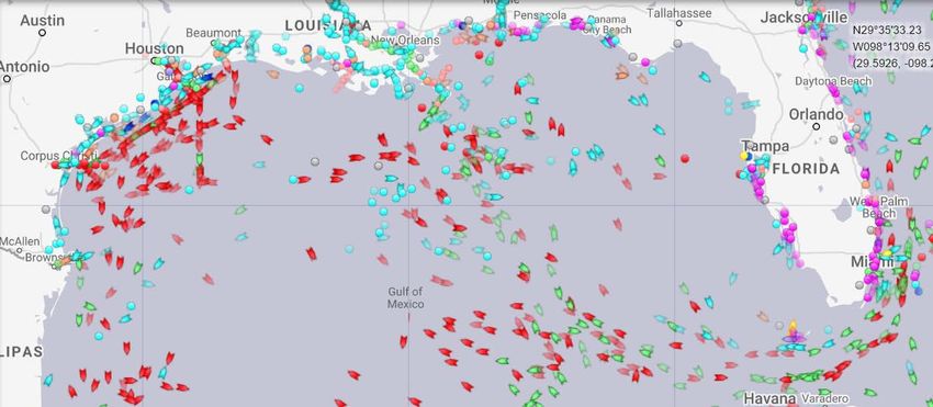
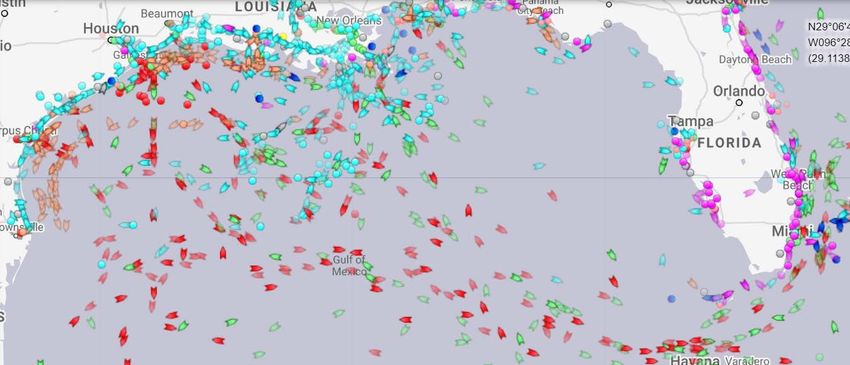
Ships over the Open Ocean

                      https://www.marinetraffic.com/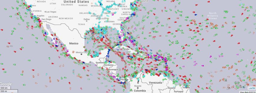
Typical areas for gale conditions

Note that the main areas for gales are near gaps and coastal terrain
                                        - this is not a coincidence!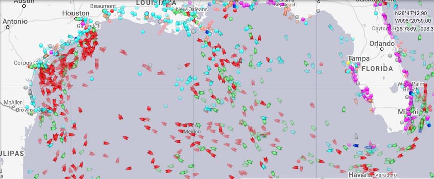
Typical areas for tropical storms and hurricanes

                June                        July

              August                  September

            October                   November
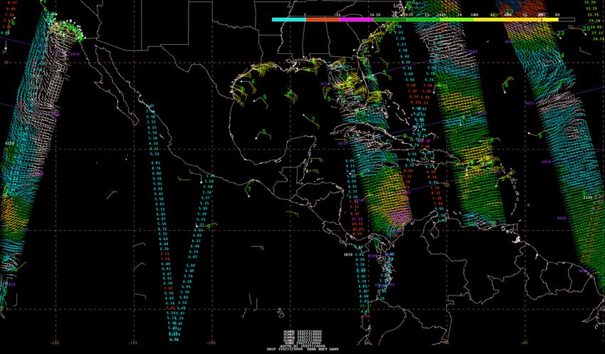
Tools - Observations
Tools - Observations

GOES-16: A new era of geo-stationary satellite imagery and data
Tools - Models
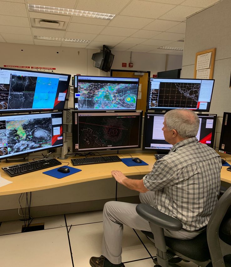
Tools - Workstations

    Tools (Observations, Models, and
             Workstations)
Unified Surface Analysis https://www.nhc.noaa.gov/t
afb_latest/USA_latest.gif
Areas of Responsibility
WPC
NHC/
TAFBTropical Weather Discussions
The Tropical Weather Discussion describes major
synoptic weather features and significant https://www.nhc.noaa.gov/t
ext/MIATWDAT.shtml
areas of disturbed weather in the tropics.
Content:
Special Features
• Tropical Disturbances
• Tropical Cyclones
• Gales/Storm/Hurricane
Warnings
Tropical Waves
ITCZ
DiscussionNHC/TAFB Wind and Wave Forecasts
High Seas and Offshores
Text Forecasts
HIGH SEAS FORECAST
NWS NATIONAL HURRICANE CENTER
1030 UTC FRI OCT 02 2015
Graphics
SUPERSEDED BY NEXT ISSUANCE IN 6 HOURS
SEAS GIVEN AS SIGNIFICANT WAVE HEIGHT...WHICH IS THE AVERAGE
HEIGHT OF THE HIGHEST 1/3 OF THE WAVES. INDIVIDUAL WAVES MAY BE
MORE THAN TWICE THE SIGNIFICANT WAVE HEIGHT.
PAN PAN
ATLANTIC FROM 07N TO 31N W OF 35W INCLUDING CARIBBEAN SEA AND
GULF OF MEXICO.
SYNOPSIS VALID 0600 UTC FRI OCT 02.
24 HOUR FORECAST VALID 0600 UTC SAT OCT 03.
48 HOUR FORECAST VALID 0600 UTC SUN OCT 04.
Grids .WARNINGS.
...HURRICANE WARNING...
.HURRICANE JOAQUIN NEAR 23.3N 74.7W 935 MB AT 0900 UTC OCT 02
MOVING NW OR 315 DEG AT 3 KT. MAXIMUM SUSTAINED WINDS 115 KT
GUSTS 140 KT. TROPICAL STORM FORCE WINDS WITHIN 160 NM W
SEMICIRCLE...140 NM NE QUADRANT AND 180 NM SE QUADRANT. SEAS 12
FT OR GREATER WITHIN 400 NM NE QUADRANT...150 NM SE
QUADRANT...120 NM SW QUADRANT...AND 300 NM NW QUADRANT WITH SEAS
TO 39 FT. ELSEWHERE S OF 28N BETWEEN 70W AND 78W WINDS 20 TO 33
KT. SEAS 9 TO 12 FT. N OF 28N BETWEEN 70W AND 75W E WINDS 20 TO
25 KT SEAS 8 TO 10 FT. REMAINDER OF AREA N OF 21N BETWEEN 65W
AND 78W AND OUTSIDE OF THE BAHAMAS WINDS 20 KT OR LESS. SEAS 8
TO 11 FT IN MIXED SWELL.TAFB National Digital Forecast Database
Gridded Marine Forecasts
Spatial/Temporal resolution
– 10 KM
– 6 Hourly out to 144 hr
(3 Hourly to 72 hr)
Parameters
– 10-M Wind/Gusts
– Significant Wave Height
– Hazards
https://digital.weather.gov/How do I get weather forecasts over the open ocean? NOAA Weather Radio - Reliable weather broadcasts out to 25nm from shore HF radio - Long distance broadcast range with coastal and offshore weather information VHF radio - Marine radio on channels 16 and 22A - Primarily broadcasts for coastal areas NAVTEX - Medium Frequency weather broadcasts on 518 khz with a range up to 200 nm - Low cost and automated InMarsat C SafetyNET - Satellite transmission of High Seas forecasts and warnings – Part of Global Marine Distress and Safety System Iridium SafetyCast – Satellite transmission of High Seas forecasts and warnings - Part of Global Marine Distress and Safety System (Becoming operational now) FTPMail - User can request and receive NWS text and graphic products via email using ftp commands - Low bandwidth email Marine Composite Page – Winds/Waves/Warnings in graphical form via low bandwidth internet - https://www.nhc.noaa.gov/marine/forecast/enhanced_atlcfull.php For more information: https://weather.gov/marine (Dissemination menu)
TAFB High Seas
• High Seas Forecast is a text forecast issued primarily for large
  ocean going vessels.
• High Seas Forecast includes synopsis of primary weather features
  and a 48 hour forecast.
• High Seas Forecast primarily for strong winds (25 KT or greater)
  and/or seas 8 FT or higher.
• TAFB issues two
  text high seas
  forecasts four
  times a day.

  https://www.nhc.noaa.gov/t
  ext/MIAHSFAT2.shtml
• OFF’s are designed for
                                  TAFB    Offshore
                                    Offshore Forecast Areas Zones
  recreational/smaller
  fishing vessels up to giant
  cargo/cruise ships.
• Warnings are issued for                310 N
  conditions up to 48 hours
                                                        350
  from issuance time. A                                 W
  headline such as “Gale
  Conditions Possible” can be
  included for events beyond 48                  70 N
  hours.
• Tropical Storm and              • Currently, Offshore Waters
  Hurricane Warnings                Forecasts extend out 5 days
  normally based on 34kt/64kt     • Winds less than 5 ft are
  wind radii given in the           described as “Variable Wind
  tropical cyclone advisory.        Less than 5 kt”
      https://www.nhc.noaa.gov/
      marine/offshores.php
• OFF’s are designed for
TAFB Offshore
Offshore Forecast Areas Zones
recreational/smaller
fishing vessels up to giant
cargo/cruise ships.
• Warnings are issued for 310 N
conditions up to 48 hours
350
from issuance time. A W
headline such as “Gale
Conditions Possible” can be
included for events beyond 48 70 N
hours.
• Tropical Storm and • Currently, Offshore Waters
Hurricane Warnings Forecasts extend out 5 days.
normally based on 34kt/64kt • Winds less than 5 ft are
wind radii given in the described as “Variable Wind
tropical cyclone advisory. Less than 5 kt”
https://www.nhc.noaa.gov/m
arine/offshores_eastpac.phpNavigational Telex (NAVTEX)
NAVTEX is an
internationally required
broadcast of coastal
urgent marine safety
information to ships.
In the United States
there are 12 U.S. Coast
Guard transmitter
locations. TAFB
products are
transmitted from
Miami, San Juan, and
New Orleans, and
contribute to the
Charleston broadcast.
https://www.nhc.noaa.gov/t
ext/MIAOFFN04.shtmlHigh Frequency Voice Broadcasts
(VOBRA)
The USCG broadcasts basic
weather information
prepared by the NWS
(Ocean Prediction Center,
National Hurricane Center
and Honolulu Forecast
Office) via high frequency
voice broadcasts (VOBRA)
to vessels operating in areas
beyond the range of coastal
NOAA Weather Radio.
The VOBRA forecasts are
prepared at a lower
resolution than the offshore
forecasts.
https://www.nhc.noaa.gov/t
ext/MIAOFFN21.shtmlMARINE RADIOFAX
TAFB provides graphical products for
three U.S. Coast Guard transmitters:
NEW ORLEANS (NMG)
POINT REYES (NMC)
HAWAII (KVM70)Surface Prog Graphics • Fronts, troughs, tropical cyclones, tropical waves, ridges • 24, 48, and 72 hr Forecasts • W. Atlantic, Caribbean, Gulf of Mexico, and E. Pacific • Issued twice daily https://www.nhc.noaa.gov/t afb_latest/atlsfc72_latestB W.gif
Sea State Analysis Graphics
•    Significant Wave Height Analysis (the average height of the
     highest one-third of the waves) and Primary Swell Direction
•    W. Atlantic, Caribbean, Gulf of Mexico, and E. Pacific
•    Issued twice daily

https://www.nhc.noaa.gov/t
afb_latest/atlsea_latestBW.
gif
WIND / WAVE Forecast Graphics • Surface Winds and Significant Wave Height Predictions • 24, 48, and 72 hr Forecasts • W. Atlantic, Caribbean, Gulf of Mexico, and E. Pacific • Issued twice daily https://www.nhc.noaa.gov/t afb_latest/atl72_latestBW.g if
WAVE PERIOD/DIRECTION Forecast Graphics
•    Dominant wave period and direction
•    48 and 72 hr Forecasts
•    W. Atlantic, Caribbean, Gulf of Mexico, and E. Pacific
•    Issued twice daily

https://www.nhc.noaa.gov/t
afb_latest/atl48per_latest.gi
f
High Wind and Seas Graphic
• 48 hr forecast depiction of Gale, Storm, and Hurricane-
  Force Wind Warnings (with peak seas)
• W. Atlantic, Caribbean, Gulf of Mexico, and E. Pacific
• Issued four times daily
• Issued 1 December to 14 May

 https://www.nhc.noaa.gov/t
 afb_latest/hiwind_pac_lates
 tBW.gif
Tropical Cyclone Danger Graphic
• Wind Speed Probabilities-Based – Uses 5% and 50%
  chance of 34 kt (tropical storm force winds)
• 5 Day Forecasts
• W. Atlantic, Caribbean, Gulf of Mexico, and E. Pacific
• Issued four times daily during hurricane season

 https://www.nhc.noaa.gov/t
 afb_latest/danger_atl_latest
 BW.gif
Marine Composite Page –
Winds, Waves, Warnings, and Features
                         https://www.nhc.noaa.gov/marine/forecast/enhanced_atlcfull.php

Red: Gale Warning                                                 Colors: Seas (in feet)
Orange: Winds > 23 kt Blue: Seas > 8 ft                           Flags: Wind barbs (in knots)
Marine Composite Page –
Winds, Waves, Warnings, and Features
https://www.nhc.noaa.gov/marine/forecast/enhanced_atlcfull.php
Red: Gale Warning Green: Storm Warning Colors: Seas (in feet)
Orange: Winds > 23 kt Blue: Seas > 8 ft Flags: Wind barbs (in knots)Marine Composite Page – https://www.nhc.noaa.gov/marine/forecast/enhanced_atlcfull.php New Features – February 2021
Hurricane Delta - 2020 October 6th, 2pm EDT Weather Avoidance by Ships

                                                         marinetraffic.c
Hurricane Delta - 2020 October 7th, 9am EDT Weather Avoidance by Ships
marinetraffic.cHurricane Delta - 2020 October 8th, 9am EDT Weather Avoidance by Ships
marinetraffic.cHurricane Delta - 2020 October 8th, 5pm EDTWeather Avoidance by Ships
marinetraffic.cHurricane Delta - 2020 October 9th, 9am EDT Weather Avoidance by Ships
marinetraffic.cHurricane Delta - 2020 October 10th, 1pm EDTWeather Avoidance by Ships
marinetraffic.cHurricane Delta - 2020 October 11th, 7am EDTWeather Avoidance by Ships
marinetraffic.c2020 Impact-based Decision Support Services to U.S. Coast Guard Districts
by Tropical Analysis and Forecast Branch (TAFB)/National Hurricane Center (NHC)
88 Hurricane Briefings
"The Spot Forecast is a huge tool year-round for "You [NHC/TAFB] are a crucial and critical
us during search-and-rescue. partner to us. On behalf of all of District 8 with
Likewise, I really want to thank all those 4,000 men and women that serve here in uniform,
responsible for creating the Coast Guard weather we are very, very grateful for the support you have
webpage, which is extremely valuable to us. It has given us. We consider you one of our key partners
so many of the products that we use on a daily to ensure that the American public is served well
basis, so I thank you and the entire team for that.” across all of District 8. We’re very proud of the
USCG District 7 Commandant relationship that we enjoy with you all. ”
RADM Eric Jones USCG District 8 Commandant
RADM John Nadeau
https://www.nhc.noaa.gov/pdf/nhc-uscg-meeting-2021.pdf2020 TAFB
Social Media Highlights
Twitter
Automated Marine Warning Tweets began January 2020
Comparing Twitter Stats from 2019 to 2020
Tweets sent Tweet Bank
126 1,527 - 545 manual tweets ● Over 100 manual tweets on
TAFB Climatology data
Profile Visits
17,010 57,476 ● Tweet Templates available for
non tropical & tropical events
Followers
Weekly Marine Briefing
23,100 27,203 +4k
● Weekly Marine Weather
Briefing macros created
twitter.com/NHC_TAFB ● Experimental 5 Day Briefing
each MondayNational Hurricane Center/Tropical Analysis and Forecast Branch
https://www.nhc.noaa.gov/marine/?atlc
1-305-229-4424 –Atlantic/Gulf/Caribbean 1-305-229-4425 –Pacific On Twitter: @NHC_TAFBYou can also read