Overview of the Use of Drones for Spectrum Monitoring Applications - Document WINNF-TR-2009
←
→
Page content transcription
If your browser does not render page correctly, please read the page content below
Overview of the Use of Drones for
    Spectrum Monitoring Applications
                Document WINNF-TR-2009
                      Version 1.0.0

                        1 November 2021

Copyright © 2021 The Software Defined Radio Forum Inc - All Rights Reserved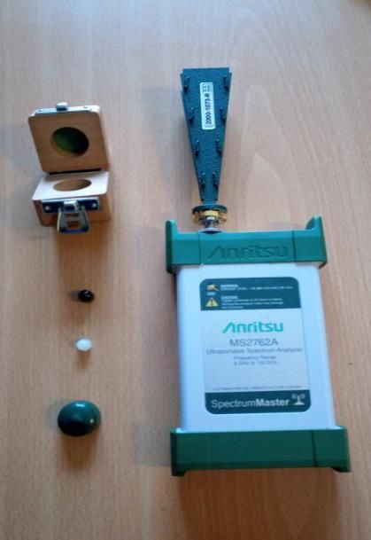
Advanced Technologies Committee
                                      Drones for Spectrum Monitoring
                                         WINNF-TS-2009-V1.0.0

                         TERMS, CONDITIONS & NOTICES

This document has been prepared by the Advanced Technologies Committee to assist The
Software Defined Radio Forum Inc. (or its successors or assigns, hereafter “the Forum”). It may
be amended or withdrawn at a later time and it is not binding on any member of the Forum or of
the Advanced Technologies Committee.

Contributors to this document that have submitted copyrighted materials (the Submission) to the
Forum for use in this document retain copyright ownership of their original work, while at the
same time granting the Forum a non-exclusive, irrevocable, worldwide, perpetual, royalty-free
license under the Submitter’s copyrights in the Submission to reproduce, distribute, publish,
display, perform, and create derivative works of the Submission based on that original work for
the purpose of developing this document under the Forum's own copyright.

Permission is granted to the Forum’s participants to copy any portion of this document for
legitimate purposes of the Forum. Copying for monetary gain or for other non-Forum related
purposes is prohibited.

THIS DOCUMENT IS BEING OFFERED WITHOUT ANY WARRANTY WHATSOEVER,
AND IN PARTICULAR, ANY WARRANTY OF NON-INFRINGEMENT IS EXPRESSLY
DISCLAIMED. ANY USE OF THIS SPECIFICATION SHALL BE MADE ENTIRELY AT
THE IMPLEMENTER'S OWN RISK, AND NEITHER THE FORUM, NOR ANY OF ITS
MEMBERS OR SUBMITTERS, SHALL HAVE ANY LIABILITY WHATSOEVER TO ANY
IMPLEMENTER OR THIRD PARTY FOR ANY DAMAGES OF ANY NATURE
WHATSOEVER, DIRECTLY OR INDIRECTLY, ARISING FROM THE USE OF THIS
DOCUMENT.

Recipients of this document are requested to submit, with their comments, notification of any
relevant patent claims or other intellectual property rights of which they may be aware that might
be infringed by any implementation of the specification set forth in this document, and to provide
supporting documentation.

This document was developed following the Forum's policy on restricted or controlled information
(Policy 009) to ensure that that the document can be shared openly with other member
organizations around the world. Additional Information on this policy can be found here:
http://www.wirelessinnovation.org/page/Policies_and_Procedures

Although this document contains no restricted or controlled information, the specific
implementation of concepts contain herein may be controlled under the laws of the country of
origin for that implementation. Readers are encouraged, therefore, to consult with a cognizant
authority prior to any further development.

Wireless Innovation Forum ™ and SDR Forum ™ are trademarks of the Software Defined Radio
Forum Inc.

    Copyright © 2021 The Software Defined Radio Forum Inc                                  Page i
    All Rights Reserved
Advanced Technologies Committee
                                                                                           Drones for Spectrum Monitoring
                                                                                              WINNF-TS-2009-V1.0.0

                                                                                   Table of Contents
TERMS, CONDITIONS & NOTICES .................................................................................................. i
Executive Summary ............................................................................................................................. iv
Contributors ........................................................................................................................................ vii
1     Introduction and Background ......................................................................................................... 1
2     Rules and Regulations for Flying Drones ....................................................................................... 4
    2.1     CANADA ............................................................................................................................................................................................................ 5
    2.2     THE UNITED STATES ...................................................................................................................................................................................... 6
    2.3     THE EUROPEAN UNION ................................................................................................................................................................................. 8
    2.4     THE UNITED KINGDOM.................................................................................................................................................................................. 9
3     Case Studies in Spectrum Compliance ......................................................................................... 10
    3.1 INDUSTRY .......................................................................................................................................................................................................10
       3.1.1    LSTelcom .................................................................................................................................................................................... 10
       3.1.2    Colibrex ....................................................................................................................................................................................... 11
       3.1.3    Nokia............................................................................................................................................................................................ 11
       3.1.4    Ericsson....................................................................................................................................................................................... 12
       3.1.5    Other equipment manufacturers/service providers ................................................................................................. 13
    3.2 SPECTRUM REGULATORS .............................................................................................................................................................................13
       3.2.1    ITU-R ............................................................................................................................................................................................ 13
       3.2.2    ISED Canada ............................................................................................................................................................................. 14
       3.2.3    ANFR ............................................................................................................................................................................................ 14
       3.2.4    Ofcom ........................................................................................................................................................................................... 15
       3.2.5    FCC ................................................................................................................................................................................................ 16
    3.3 RESEARCH PROGRAM ...................................................................................................................................................................................16
       3.3.1    Spectrum Monitoring to Detect Radio Interference .................................................................................................. 17
       3.3.2    Spectrum monitoring using drones and cognitive radio ........................................................................................ 17
       3.3.3    Radio frequency interference measurements using drones ................................................................................... 17
       3.3.4    Interference Assessment for Private 5G networks using drones .......................................................................... 18
       3.3.5    Drone-Based GPS Jammer Localization ......................................................................................................................... 19
       3.3.6    Research Activities by Academic institutions in the United States ...................................................................... 19
4     Simulation Tools for Spectrum Monitoring .................................................................................. 21
    4.1     CRC COVLIB ................................................................................................................................................................................................22
    4.2     CRC PATHTRACER .......................................................................................................................................................................................22
    4.3     INFOVISTA PLANET ENGINE .......................................................................................................................................................................22
    4.4     GNURADIO (OPENSOURCE) ........................................................................................................................................................................22
    4.5     NS3 (OPEN SOURCE)...................................................................................................................................................................................23
    4.6     OMNET++ (OPEN SOURCE) ......................................................................................................................................................................23
    4.7     RECOMMENDATIONS ....................................................................................................................................................................................23
5     Considerations and Observations of Use of Drones for Spectrum Monitoring ............................ 24
    5.1     REGULATIONS FOR FLYING DRONES..........................................................................................................................................................24
    5.2     DRONE TYPE ..................................................................................................................................................................................................24
    5.3     DRONE OPERATION COST ...........................................................................................................................................................................24
    5.4     SENSOR PAYLOAD .........................................................................................................................................................................................25
    5.5     EMC SHIELDING AND CLOSE PROXIMITY MONITORING ........................................................................................................................25
    5.6     PATH PRE-CONFIGURATION ........................................................................................................................................................................26

                Copyright © 2021 The Software Defined Radio Forum Inc                                                                                                                                            Page ii
                All Rights Reserved
Advanced Technologies Committee
                                                                                     Drones for Spectrum Monitoring
                                                                                        WINNF-TS-2009-V1.0.0

    5.7 IMU AND FLIGHT CONTROL .......................................................................................................................................................................26
    5.8 BVLOS CAPABILITY .....................................................................................................................................................................................27
6     Use Case Summary ....................................................................................................................... 27
    6.1    RADIO TOWER INSPECTION AND COMPLIANCE VERIFICATION ............................................................................................................27
    6.2    CELLULAR RADIO TOWER EMISSIONS COMPLIANCE ..............................................................................................................................27
    6.3    BROADCAST STATION COMPLIANCE ..........................................................................................................................................................28
    6.4    HIGH POWER TOWER TO TOWER INTERFERENCE ..................................................................................................................................28
    6.5    MICROWAVE LINK MONITORING ...............................................................................................................................................................28
    6.6    INTERFERENCE AND LOCALIZATION FOR 5G NETWORKS ......................................................................................................................28
    6.7    ABOVE GROUND INTERFERENCE DETECTION ..........................................................................................................................................28
7     Conclusions .................................................................................................................................. 29
References ........................................................................................................................................... 29

                                                                                   List of Figures
      Figure 1: Compact spectrum analyzers and drone used by ANFR. .............................................. 15

                                                                                    List of Tables
      Table 1: Industries that Use Drones for Monitoring Service .......................................................... 2
      Table 2: Public Organizations and Agencies that Use Drone for Monitoring Services. ................ 3
      Table 3: Academic Institutions in the United States Currently Carrying Out Drone Research ... 19

                Copyright © 2021 The Software Defined Radio Forum Inc                                                                                                                           Page iii
                All Rights Reserved
Advanced Technologies Committee
Drones for Spectrum Monitoring
WINNF-TS-2009-V1.0.0
Executive Summary
This report summarizes spectrum monitoring technologies and regulations using drones,
also known as Unmanned Aerial Systems (UAS) or Vehicles (UAV). Spectrum monitoring
is a critical component for the spectrum management process to support functions such as:
1) spectrum assignment and planning, 2) monitoring data concerning the actual use of
frequencies and bands including channel occupancy and band congestion, 3) verifying
proper technical and operational characteristics of transmitted signals to ensure that
technical parameters and standards for radiocommunication systems are adhered to, and 4)
detect and identify illegal transmitters. This report focuses on the spectrum compliance
activities, i.e., 3) and 4).
Compliance activities by regulators ensures that spectrum is being used as intended. They
typically include but are not limited to:1) tower inspection and compliance verification, 2)
verification of proper technical and operational characteristics of radiated signals, and 3)
detection, identification, and localization of illegal interfering transmitters.
Currently, ground-based sensor systems are mostly used in spectrum monitoring
applications. Since ground-based systems have limited antenna heights from the ground,
they may experience inferior performance due to the environment such as surrounding urban
buildings. In some applications such as tower inspection and microwave link measurements,
the desired measurement locations may be inaccessible to ground-based systems. The use of
drones for spectrum monitoring has been shown to be a promising technology to counter the
limitations and inefficiencies of ground-based systems. Drones have significant benefits for
spectrum monitoring including 1) flying to locations inaccessible to ground-based
measurements, 2) ascending in altitude providing improved line-of-sight (LOS) to
transmitters particularly in mountainous and dense urban environments, 3) making three-
dimensional measurements of a transmitter by moving to various heights enabling 3-
dimensional antenna pattern measurements, and 4) determining the height of a transmitter.
Drones are aircraft and the operators of drones are pilots. When flying drones, there are
rules and regulations that need to be followed. Currently, there are no unified rules for all
countries. This report summarizes regulations in Canada, the United States, the European
Union, and the United Kingdom. Most countries require special flight authorizations for
typical spectrum monitoring scenarios, which takes time to acquire and affects the
effectiveness of the use of drones for this application. However, as new technologies such as
onboard detect and avoid (DAA) systems are being applied to improve the safety of drones,
the aviation authorities are opening the sky for more complex operations. It is possible to
work with the national aviation authorities to expedite the process of obtaining special
approval or operation waiver for flying drones for spectrum monitoring applications.
There are a few companies offering commercial drone solutions for spectrum monitoring.
LSTelecom provides spectrum monitoring services and its subsidiary Colibrex specializes in
producing specific-purpose drones for RF measurements. Nokia and Ericsson both have
capabilities in their drone operations to measure spectrum but don’t currently provide any
services.
Copyright © 2021 The Software Defined Radio Forum Inc Page iv
All Rights ReservedAdvanced Technologies Committee
Drones for Spectrum Monitoring
WINNF-TS-2009-V1.0.0
We survey the activities by spectrum regulators on the use of drones for spectrum
measurement. The International Telecommunication Union Radiocommunication (ITU-R)
has published a report on functional components of drone-based monitoring systems.
Innovation, Science and Economic Development (ISED) Canada is collaborating to provide
air unmanned traffic management (UTM) services to Remotely Piloted Aircraft Systems
(RPAS) for Beyond Visual Line of Sight (BVLOS) in rural areas to reduce flight
authorization time. The National Frequency Agency (ANFR) in France has been
experimenting since 2017 on the use of drones for spectrum measurement activities. The
Office of Communications (Ofcom) in the United Kingdom has been experimenting with
the use of drones for the last 5 years in rural area to verify coverage and carry out antenna
pattern measurements. The Federal Communications Commission (FCC) in the United
States does not currently have any drone applications or drone equipment. However, they
haven’t ruled out use of drones and see the benefits where elevation is required to detect
interference.
Academic institutions are making significant contributions on a broad range of research
interests benefiting a variety of industries including aerospace and defense, national defense,
public safety, conservation, manufacturing, materials, technology, and health. We survey
only academic research activities that are focused specifically on the use of drones for
spectrum monitoring purposes.
Wide-scale field testing of drone spectrum monitoring techniques is impractical. Simulation
is a low-cost solution that requires no special equipment or flying/spectrum usage permits.
Requirements for simulating spectrum monitoring using drones include 1) an ability to
simulate radio frequency (RF) propagation in a 3D environment and 2) a capability to model
transmitters and receivers, including drones, moving in that space. Two types of tools are
discussed. The first models the characteristics of point-to-point or point-to-multipoint RF
propagation within a static 3D environment. The second type are network simulation tools.
Many simulators that support in-depth RF coverage, propagation, and planning (e.g.,
COVLIB, PathTracer, and Planet) do not support movement of transmitters/receivers during
simulation. Most network simulators that support movement have not implemented detailed
RF simulation (e.g. NS3 and OMNET++). It is recommended that detailed RF
measurements from COVLIB, PathTracer, and Planet can be integrated into OMNET++
using the open source GNU Radio libraries.
We detail considers and observation on the use of drones for spectrum monitoring. We
conclude that
• regulation is currently a major limiting factor for drone use in spectrum monitoring.
However, situation will improve as regulators are opening more sky as new
technologies are being applied to improve the safety of drones.
• multi-rotor drones are best suited for spectrum monitoring, and commercial off the
shelf (COTS) equipment available today have the right capabilities to meet the basic
requirements for sensor payload on drones for spectrum monitoring.
• Electromagnetic Compatibility (EMC) shielding and Inertial Measurement Unit
(IMU) are critical and essential for drone use in spectrum monitoring.
Copyright © 2021 The Software Defined Radio Forum Inc Page v
All Rights ReservedAdvanced Technologies Committee
Drones for Spectrum Monitoring
WINNF-TS-2009-V1.0.0
• the capabilities of path pre-configuration and Beyond Visual Lines of Sight
(BVLOS) are desirable for drone use. Transportation Canada is currently testing
RPAS Traffic Management (RTM) services that may expedite the authorization of
BVLOS operations in the future.
We identify and summarize seven use cases where the use of drones can be beneficial: 1)
Radio Tower Inspection and Compliance Verification, 2) Cellular Radio Tower Emissions
Compliance, 3) Broadcast Station Compliance, and 4) High Power Tower to Tower
Interference, 5) Microwave Link Monitoring, 6) Interference Assessment for 5G networks,
and 7) Above Ground Interference Detection.
Finally, we conclude that as new technologies such as onboard detect and avoid (DAA)
systems are being applied to improve the safety of drones, the aviation authorities are
opening the sky for more complex operations. Drones in the future will become less
restricted making the use of drones practical for spectrum monitoring.
Copyright © 2021 The Software Defined Radio Forum Inc Page vi
All Rights ReservedAdvanced Technologies Committee
Drones for Spectrum Monitoring
WINNF-TS-2009-V1.0.0
Contributors
Yifeng Zhou
Louise Lamont
Paul Astell
David Kidston
Samantha Murphy
John Glossner
Copyright © 2021 The Software Defined Radio Forum Inc Page vii
All Rights ReservedAdvanced Technologies Committee
Drones for Spectrum Monitoring
WINNF-TS-2009-V1.0.0
Overview of the Use of Drones in Spectrum Monitoring
Applications
1 Introduction and Background
Spectrum monitoring is the process of observing the radio frequency spectrum and reporting on its
use. It serves as the eyes and ears of the spectrum management process to support various functions
such as spectrum assignment and planning [02]. Spectrum monitoring is able to provide valuable
data concerning the actual use of frequencies and bands to the spectrum management process (e.g.,
channel occupancy and band congestion) to: support spectrum assignment and planning functions;
help verify proper technical and operational characteristics of transmitted signals to ensure that
technical parameters and standards for radiocommunication systems are adhered to; and detect and
identify illegal transmitters. Compliance activities by regulators ensures that the spectrum is being
used as intended. They typically include but are not limited to [02]
• tower inspection and compliance verification,
• verification of proper technical and operational characteristics of radiated signals,
• detection, identification, and localization of illegal interfering transmitters.
Non-compliance issues can occur due to the complexity of the equipment, interaction with other
equipment, a malfunction or deterioration of equipment, misconfiguration of equipment, deliberate
misuse or intentional interference. With the emergence of new technologies and the recent
phenomenal growth of wireless services, there has been an exponential growth in spectrum usage in
the last two decades, leading to a significant increase in the occurrence of interference among the
systems. Furthermore, as RF technologies have become increasingly more accessible to the public,
intentional interference (typically not malicious) has been observed to exacerbate in recent years
[04]. These factors have resulted in increased challenges in efficiently carrying out spectrum
compliance activities.
Currently sensors in spectrum monitoring are mostly ground-based, which include fixed,
transportable, mobile, manpack and handheld systems. Fixed F systems are installed at permanent
monitoring sites with antennas mounted on a tower. They have good line-of-sight (LOS) conditions
and wide coverage but at considerable cost. Transportable systems are a simplified version of fixed
sensors that can be transported to different locations to carry out temporary spectrum measurement
jobs. Mobile systems are systems mounted in vehicles, which carry out spectrum measurements as
the vehicles moves along. Mobile systems are flexible but their movement is constrained by streets
or accessible pathways. Manpack and handheld systems are small size and lightweight sensors that
can be carried by a person. They usually have limited frequency range and low sensitivity and are
typically used for last-mile hunting for interference. Ground-based sensors have limitations for
certain compliance applications because their antennas have limited height from the ground. For
example, ground-based sensors cannot reach to the desired locations to measure signals of
microwave links and very-small-aperture terminals (VSATs). In certain geographic areas such as
valleys, canyons and urban areas, ground-based sensors may experience measurement difficulties
due to blockage and multipath effects caused by buildings and terrain etc. For example, it was found
Copyright © 2021 The Software Defined Radio Forum Inc. Page 1
All Rights ReservedAdvanced Technologies Committee
Drones for Spectrum Monitoring
WINNF-TS-2009-V1.0.0
that in Korea, ground-based sensors can only monitor 35% of the geographical areas nationwide,
and the remaining 65% of the areas is left uncovered [03]. To deal with the inefficiencies of ground-
based sensors, there is a growing and increasingly urgent requirement for the development of new
flexible deployable monitoring solutions that will allow regulators to carry out spectrum monitoring
more effectively and efficiently.
The use of drones for spectrum monitoring has recently attracted interest from regulators and
private industries across the world due to their potential advantages and unique features as a
complementary technology to current spectrum management practices. Both civilian and military
applications have accelerated over the last decade mainly attributed to their steadily decreasing
costs and improved technical and safety capabilities and portability. They are also driven by
applications and operational requirements which may not be met by other tools or systems.
Drones can be operated with the addition of various payloads and have been used for a variety of
civilian and military applications including combat, surveillance, monitoring, disaster relief,
agriculture, transportation logistics and security etc. Among these applications, monitoring is one of
the most popular applications for drones. Generally speaking, all drone monitoring applications are
similar and include 1) measurement tools (i.e., sensors), 2) flight-based information acquisition, and
3) analysis based on the collected data. The main differences between different monitoring
applications are in the type of drones used, the types of sensors onboard the drones, and how the
information is collected during the mission. Drones may also need to be designed and optimized
with certain capabilities to adapt to specific applications to enhance the performance and efficiency
of the drones. Table 1 shows different industries, by sector, that are currently using monitoring
services. They encompass a wide range of industries from aerospace to manufacturing.
Table 1: Industries that Use Drones for Monitoring Service
Private Sectors Industries
aerospace & defense services, construction &
engineering services, environmental services,
Industrials
manufacturing & facilities’ services &
transportation services
Communication Services cell towers & communication facilitators
Energy exploration of renewable energy
Utilities generation & distribution of renewable energy
Materials mining & manufacturing & facilities’ services
software, hardware & other related
Information Technology instruments/semiconductors, IT service
providers & communications equipment
Healthcare emergency service providers
Real Estate real estate services & real estate development
Consumer Staples manufacturing & facilities’ services
Consumer Discretionary manufacturing & facilities’ services
Copyright © 2021 The Software Defined Radio Forum Inc. Page 2
All Rights ReservedAdvanced Technologies Committee
Drones for Spectrum Monitoring
WINNF-TS-2009-V1.0.0
Table 2outlines the different publicly funded organizations and agencies using drone monitoring
services. The definition of a publicly funded organization varies by country but broadly they
include law enforcement, regulators, healthcare , education, etc.
Table 2: Public Organizations and Agencies that Use Drone for Monitoring Services.
Public Sectors Organizations & Agencies
Public Safety law enforcement, military & emergency
services
Regulatory Agencies various
Conservation / Parks & Recreation various
Transportation various
Healthcare distribution of medical supplies; remote
medical exams
Education on-going research & specialized aviation
training programs
Public Works Projects construction & engineering services;
inspection & maintenance services & project
management services
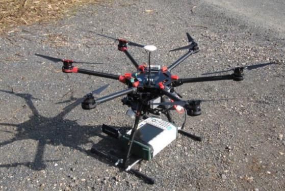
In spectrum monitoring applications, drones carry RF sensors and/or other types of sensors such
as a camera when required. The main advantage of using drones in spectrum monitoring is their
ability to elevate far above what a ground-based sensor system can reach. The additional
elevation may prove extremely beneficial for countering the inefficiencies of ground-based
sensors. Specific benefits of using drones for spectrum monitoring applications can be
summarized as follows:
• drones can fly to desired locations, which are usually inaccessible by ground-based sensors,
to carry out spectrum measurements. These scenarios include the Fresnel zone measurement
of station towers, microwave links, and VSAT ground stations.
• drones can ascend in altitude to provide improved line-of-sight (LOS) conditions to the
transmitters. This is important in scenarios such as mountainous areas with complex terrain,
and dense urban environments. This benefit is particularly important for interference
detection and localization in urban scenarios where severe shadowing and multipath effects
make interference localization extremely difficult.
• drones can make three-dimensional measurements of a transmitter by moving to various
heights during the measurement. This makes 3-dimensional antenna pattern measurements
and interference localization possible. Another use case for 3-dimensional localization is
determining both the location of a transmitter and its height. This is important for the
resolution of interference in urban scenarios because the regulators may need to know where
and on which floor the interference is located. A ground-based sensor can only localize in a
2-dimensional plane.
• drones move fast and over flexible routes, making them efficient in interference detection.
This report provides an overview of activities by various national spectrum regulators, industries,
and academics in using drones for spectrum monitoring applications. Note that we may use the
terms “spectrum monitoring” and “spectrum measurement” interchangeably. Spectrum
Copyright © 2021 The Software Defined Radio Forum Inc. Page 3
All Rights ReservedAdvanced Technologies Committee
Drones for Spectrum Monitoring
WINNF-TS-2009-V1.0.0
monitoring is typically used to refer to long-term continuous measurement and observations of
certain sites while spectrum measurement is used to describes the process of measuring RF
transmissions of a site at certain specific time instances. The report is organized as follows:
• In Section 0, the rules and regulations for drone flight operations in different
countries are described, which include Canada, the US, the UK and the European
Union (EU). There are no international standards at this time. Even within a
country (e.g., the United States), the laws may be different for each state or
province. Note that drone regulations are in a constant state of change. This report
only provides an overview as of the time of publication.
• In Section 3, we provide a survey of the use of drone for spectrum monitoring by
industries, regulators and academia. The survey is based on both publications in
the literature and interviews with managers, engineers, and field operators from
regulatory organizations and companies across the world. The companies
included are LSTelecom, Colibrex, Nokia, Ericsson and a brief discussion on
others. The regulatory organizations include ITU-R (The International
Telecommunication Union Radiocommunication), ISED (Innovation, Science and
Economic Development Canada), ANFR (The National Frequency Agency) of
France, Ofcom (The Office of Communications) in the United Kingdom and FCC
(The Federal Communications Commission). Implications of the activities for
spectrum monitoring are also discussed.
• Section 4 provides a survey of simulation tools and use cases that could be used
for spectrum monitoring simulations. The selection of appropriate tools is one of
the key issues with any simulated virtual environment, including its simulation
capabilities for drones. Some key propagation and network simulation tools that
could be used to evaluate the effect of using drones for spectrum monitoring are
discussed, and recommendations of tools are provided for simulating drones
acting as a spectrum monitoring and measurement system.
• In Section 5, we discuss the considerations and requirements of drones use in
spectrum monitoring applications including drone flight regulations, drone type and
weight, sensor payload, EMC (Electromagnetic Compatibility) shielding, path
planning, drone navigation and stabilization, and control and data links.
• In Section 0, we summarize and discuss a set of spectrum monitoring use cases that
the use of drones can be of benefit to. Finally, in Section 0, conclusions s are
provided.
2 Rules and Regulations for Flying Drones
Drones are aircraft and the operators of drones are pilots. When flying drones, there are
rules and regulations that need to be followed. Currently, there are no unified rules for
all countries. Each country has different specific laws and regulations. In the following,
we briefly describe the rules and regulations for drone operations in Canada. The
discussions of rules and regulations for the US, the UK and the European Union (EU)
are included in Annex B. Note that the EU has recently introduced new regulations for
drone operations with the aim to achieve harmonization between EU states and make the
regulatory process easier. The new regulations came into effect on January 1, 2021. It is
noteworthy that drone regulations by nations are in a constant state of change. What is
Copyright © 2021 The Software Defined Radio Forum Inc. Page 4
All Rights ReservedAdvanced Technologies Committee
Drones for Spectrum Monitoring
WINNF-TS-2009-V1.0.0
described in the following text only provides an overview as of the time of publication.
Drone manufacturers are working with regulators to enhance airspace compliance by the
adding “geofencing” that prevents flights in unapproved airspace.
2.1 Canada
In Canada, flying drones must follow the rules in the Canadian Aviation Regulations (CARs)
[05]. Part IX of the regulations contains most of the rules that apply to drones up to 25 kg. What
we describe in the following are the new rules that came into force on June 1, 2019 [06].
The new rules apply to all pilots flying drones between 250 g and 25 kg that are operated within
the drone pilot’s visual-line-of-sight. For drones that weigh over 25 kg or fly outside the rules
(above 122 metres or at an advertised event), a Special Flight Operation Certificate (SFOC) is
required from Transport Canada. Drones for spectrum monitoring are most likely below the 25
kg weight limit. All drones or Remotely Piloted Aircraft Systems (RPAS) with a maximum
takeoff weight of less than 25 kg must be registered, and a drone pilot license is required for
flying. Transport Canada has put together a list of drones and operations they are allowed to be
used for [06].
Transport Canada categorizes drone flights as basic or advanced operations. The following five
conditions are used to determine the type of operation.
- flying in controlled airspace
- flying over bystanders
- flying within 30 metres (100 feet) of bystanders (measured horizontally)
- flying less than 5.6 km (3 nautical miles) from a certified airport or a military aerodrome
- flying less than 1.9 km (1 nautical mile) from a certified heliport
If any one of these conditions is met, the flight is classified as an advanced operation; otherwise,
the flight is a basic operation.
- For basic operations, drones need to be registered with Transport Canada before the first
flight.
- For advanced operations, extra steps are required. The drones are required to have
appropriate safety declarations for the intended operation and to pass a flight review with a
flight reviewer. In addition, permission from air traffic control is required if the drones will
fly in controlled airspace. The permission can be requested via an RPAS Flight Authorization
from NAV CANADA.
While flying, drones must be below 122 metres (400 feet) of altitude and within visual-line-of-
sight at all times of either the pilot or a visual observer.
Aside from the specific outline of Basic and Advanced operations, other laws should be
respected when flying, including relevant sections of the Criminal Code, Offences against Air or
Maritime Safety, Breaking and Entering, Mischief, the province’s trespass act laws related to
voyeurism and privacy, and the privacy rights of others.
Copyright © 2021 The Software Defined Radio Forum Inc. Page 5
All Rights ReservedAdvanced Technologies Committee
Drones for Spectrum Monitoring
WINNF-TS-2009-V1.0.0
Implications for spectrum monitoring
The weight limit for drones (less than 25kg including payload) is a significant simplifying factor
for using drones in any environment in Canada. In fact, most of the drones we have surveyed for
monitoring purposes fall in this category. For example, the Tarot T-18 weighs 7.4kg and can
carry a payload up to 8kg.
Spectrum compliance activities will likely be considered Advanced operations since they may be
conducted in controlled airspace such as downtown core of a city, areas with bystanders, or
places close to airports, or flying over people. Advanced operations also have requirements on
pilot certification and drone registration. While pilot certification is not a particularly lengthy or
expensive process, the longer-term practicalities of ensuring regular practice for pilots does add
operational burden to the pilots and the organization. For certain monitoring scenarios, such as in
a built-up area and flying above the 400 feet height for tower inspection, an SFOC will be
required, which may require defining the area of operation of the drones. In this case, it may be
necessary to use ground-based sensor measurement results to determine the area of interest and
whether it is in a zone that requires SFOC.
The current process of obtaining an SFOC is lengthy and typically takes a couple of weeks. For
interference detection applications, this process is too long to be practical. The application needs
to be expedited in a timely manner. The spectrum regulators could have a drone operation waiver
from Transport Canada that would entitle them to fly over certain urban areas without going
through the application process. Recently, DGEPS (Director General Engineering, Planning and
Standards Branch) within the Spectrum Telecommunications Sector (STS) of ISED and
Transport Canada are collaborating on the RTM (Remote Piloting Aircraft System Traffic
Management) project to test the use of various technologies to provide air traffic management
services to RPAS. The technologies include mobile and satellite network technology as a
command and control (C2) link to relay data between RPASs and the remote pilot for BVLOS
(Beyond Visual Line of Sight) applications in rural areas, and radar for object detection and
collision avoidance. With RTM, flight authorizations could be expedited in a timely manner in
order to quickly detect and localize interference in the area of interest.
2.2 The United States
Currently, within the United States, most users operate small, unmanned aircraft due to their
affordability and ease of operation. For this reason, many regulations summarized on the
Federal Aviation Administration (FAA) website pertain to this type of drone. The FAA
define small, unmanned aircraft (sUAS) as any aircraft weighing 55 lbs. (25 kg) or less
in its entirety, i.e., systems, cargo, and payload and can operate without a pilot on-board.
There are four categories of sUAS operators: recreational hobbyists, educational users
(teachers and their students), certified civilian or foreign remote pilots, civilian or
foreign, and public safety and government organizations. The FAA is adding
regulations to require drones to continuously broadcast the drone ID and location,
including the controller location.
Copyright © 2021 The Software Defined Radio Forum Inc. Page 6
All Rights ReservedAdvanced Technologies Committee
Drones for Spectrum Monitoring
WINNF-TS-2009-V1.0.0
Both recreational hobbyists and educational users must fly their sUAS solely for personal
enjoyment or educational purposes. Civilian and foreign operators who wish to become certified
pilots, must pass required knowledge tests, training programs and formally register their aircraft.
Law enforcement, fire fighters, and other public safety and government users, have two options.
The first option allows individual organization members to become FAA certified remote pilots.
The second option allows the organization itself to become a “public aircraft operator” by
obtaining a certificate of authority from the FAA granting them the right to “self-certify” remote
pilots. In most cases, public safety and government organizations choose the former option All
four categories of operators must adhere to the following FAA rules:
• must not operate outside visual-line-of-sight (VLOS) of the pilot,
• must not operate above 400 ft above-ground-level (AGL),
• allowed to operate within controlled airspaces B, C, D & E with Air Traffic Control
(ATC) permission,
• allowed to operate in uncontrolled airspace G without ATC permission
• The Operations Over People rule became effective on April 21, 2021. Drone pilots
operating under Part 107 may fly at night, over people and moving vehicles without a
waiver as long as they meet the requirements defined in the rule. Airspace authorizations
are still required for night operations in controlled airspace under 400 feet.
• must not operate under a covered structure or within a covered stationary vehicle,
• must not operate from a moving aircraft,
• must not operate from a moving vehicle, unless operating in a sparsely populated area,
• must not operate carelessly, recklessly, or carry hazardous materials,
• must not fly more than one sUAS at a time.
Certain objectives, industry requirements, research experiments and other uncommon situations
necessitate exception to the federal restrictions outlined above. Exceptions are granted on a case-
by-case basis by providing the FAA with a detailed proposal. Essentially this includes a
completed waiver application accompanied by supporting documentation which is used by the
FAA to validate the information outlined in their application.
Individual states vary in degree of government involvement. Most states impose restrictions in
addition to federal rules and regulations. These restrictions typically concern law enforcement,
civil procedure, and the creation of “no fly zones.” A few states choose not to impose further
restrictions on unmanned aircraft usage so as not to impede technology development or restrict
related commerce.
Implications for spectrum monitoring
Applications for exception to the federal restrictions can be granted on a case-by-case basis by
providing the FAA with a detailed proposal.
Many institutions working closely with the FAA receive multiple Certificates of Authority
(COAs) allowing them to certify their own remote pilots, enjoy access to hundreds-of-thousands
of square miles of airspace, and can operate multiple UAVs simultaneously within the same
airspace.
Copyright © 2021 The Software Defined Radio Forum Inc. Page 7
All Rights ReservedAdvanced Technologies Committee
Drones for Spectrum Monitoring
WINNF-TS-2009-V1.0.0
2.3 The European Union
The new EU regulations for flying drones came into force On January 1, 2021, which
standardizes drone regulations across the continent. The new rules replace each EU state’s
existing laws and apply to all drone operators.
• The new European regulatory framework classifies each technology into three separate
categories: Open, Specific and Certified. Additional criteria such as weight, certification,
operator qualification, and operations will also help determine the category that drones
fall into.
• The Open Category is considered low risk and applies to most consumer drones and
drones that don’t transport goods. Drones operating in this category will not require
authorization from a national aviation authority (NAA) for standard operations that fall
within its defined scope. The open category is further divided into subcategories A1 (<
250 g), A2 (< 2 kg) and A3 (< 25 kg) depending on the danger posed by its intended
operation. Note: all masses specified are mass at take-off including payload and fuel.
o A1 applies to drones that weigh less 250g. In the operations, drone must not fly
over people.
o A2 applies to drones between 900g and 4kg. In addition to A1 restrictions, the
drone operations must take place at a safe horizontal distance of at least 30 meters
from uninvolved persons.
o A3 applies to drones that weigh less than 25 kg. The operation must reasonably
ensure the safety of uninvolved people and must be at a safe horizontal distance of
at least 150 meters from residential, commercial, industrial or recreational areas.
• The Specific Category applies to drone operations where flights pose a level of risk
greater than the Open Category. Advanced operations such as BVLOS fall into this
category. There are three ways to operate in this category:
o The operation is conducted under a Standard Scenario published by the European
Union Aviation Safety Agency (EASA) or NAA. A declaration needs to be
submitted to the NAA for the operation.
o The operation is not conducted under a Standard Scenario. Drone operators must
perform a risk appraisal according to the Specific Operations Risk Assessment
(SORA) or a Predefined Risk Assessment (PDRA) or other alternatives accepted
by their local NAA. Authorization will be provided if the mitigations put in place
are considered enough to ensure the safety of the operation by the authority.
o The operation is conducted under the responsibility of an operator with a Light
UAS Operator Certificate (LUC).
• The Certified Category applies to operations that are considered the highest risk. For
example, a drone flight that involves the transportation of people or dangerous goods
would fall into this category.
Implications for spectrum monitoring
Spectrum monitoring operations typically involve drones above 4 kg and less than 25 kg and
take place both in urban and suburban area. They would likely fall into the Open Category (A3)
Copyright © 2021 The Software Defined Radio Forum Inc. Page 8
All Rights ReservedAdvanced Technologies Committee
Drones for Spectrum Monitoring
WINNF-TS-2009-V1.0.0
and the Specific Category. This requires operators to submit declarations to their NAA and
perform proper risk appraisal.
2.4 The United Kingdom
On the 1st January 2021 a new Regulation came into effect in the UK which creates
manufacturer standards (class C0 to C6) for any drones placed into the market from 1st January
2023. The following descriptions focuses on Legacy Drones, i.e., drones that are already on sale
and operating within the UK.
In the UK, drone flights are classed into OPEN, Specific, and Certified categories according to
the level of risk they pose to the public and other airspace users. The Categories dictate where
drones of a certain weight and type can fly, and how close they can fly to uninvolved people,
crowds and built-up areas.
• The OPEN category: general limitations for (Legacy) drones flying in the OPEN category
include the following:
o Drones must have a take-off mass less than 25kg.
o Drones must not fly over any assemblies of people.
o Drones and their surrounding airspace must have direct, unaided VLOS of the
drone during the flight.
o Drones must not fly within the Flight Restricted Zone (FRZ) of a protected
aerodrome, or in any other restricted airspace, without the appropriate permission.
o Drone must not fly close to or inside an area where an emergency response is
ongoing, without permission from the responsible emergency service.
• The OPEN category further splits into three subcategories: A1, A2 and A3, and further
conditions and limitations apply.
o The A1 Subcategory is available to Legacy drones with a maximum take-off mass
of less than 250g (known as A1 Transitional drones). These drones are allowed
fly over people.
o The A2 Subcategory is available (until 31st December 2022) to legacy drones
with a take-off mass of less than 2Kg (known as A2 Transitional Drones). These
drones are allowed to fly close to (50 metres away horizontally from) people.
o The A3 Subcategory is available to Legacy drones with a maximum take-off mass
of less than 25Kg (known as A3 Transitional Drones). These drones must fly far
(at least 150 metres horizontally) from people.
• The SPECIFIC category: any drone operations outside of the OPEN category must apply
to the Civil Aviation Authority (CAA) for permission to operate in the SPECIFIC
category. If granted, an Operational Authorisation will be issued, which sets out the
parameters within which the drone operations may take place. Standard conditions for
flying in the Specific Category include:
o Drones must have a maximum take-off weight of less than 25 kg.
Copyright © 2021 The Software Defined Radio Forum Inc. Page 9
All Rights ReservedAdvanced Technologies Committee
Drones for Spectrum Monitoring
WINNF-TS-2009-V1.0.0
o Drones must be maintained within VLOS with a maximum distance of 500m
horizontally. Pilots can be assisted by a single Unmanned Aircraft Observer next
to the pilot and they must maintain VLOS of the drone and its surrounding
airspace during the flight.
o Drones must not fly more than 120m from the surface.
o Drones must not fly within the FRZ of a protected aerodrome without the
appropriate permission.
o Drones must not fly within 50m horizontally of any assemblies of people, and
within 50m of any uninvolved person, except that during take-off and landing this
distance may be reduced to 30 metres.
o Drones must be equipped with a mechanism to land in the event of disruption to
or a failure of any of its control systems, including the radio link, and the remote
pilot must have ensured that this mechanism is in working order before the
aircraft commences its flight.
• The CERTIFIED category: any drone that has UAS Operations that are very complex or
that present the same high risk as manned aviation must apply to the CAA for permission
to operate in the CERTIFIED category.
Implications for spectrum monitoring
Spectrum monitoring operations typically use drones that weigh between 5 and 25 kg and are
required to fly over and/or near people. Thus, they will not comply with all conditions set out by
the OPEN and SPECIFIC categories. This requires operators to be in possession of a non-
standard Permission/Operational Authorisation granted by the CAA which exempts them from
complying with any of the above.
3 Case Studies in Spectrum Compliance
In this section, we survey the spectrum activities of industries, regulators and academia.
3.1 Industry
There are a few companies offering commercial drone solutions for spectrum monitoring. There
are also other companies with mature capabilities and extensive domain knowledge of wireless
that could be adapted for spectrum monitoring applications. This section does not specifically
cover manufacturers of consumer-oriented drones (e.g., DJI, Parrot, Intel). However, we
reference them when end user companies or regulators use them in spectrum monitoring
applications. The same applies to specific purpose commercial drone manufacturers (e.g.,
Boeing, BAE systems).
3.1.1 LSTelcom
LSTelcom AG is a provider of a number of wireless products and services including spectrum
monitoring (www.lstelcom.com). Their spectrum monitoring service includes fixed and mobile
monitoring devices along with the LS Observer software platform to collect measurements and
provide visual intelligence. Their LS Observer platform includes a spectrum monitoring service
provided by purpose-specific spectrum monitoring drones. The two drone platforms provide a
spectrum measurement capability with direction finding from 20MHz to 6GHz or 32GHz
depending on the models.
Copyright © 2021 The Software Defined Radio Forum Inc. Page 10
All Rights ReservedAdvanced Technologies Committee
Drones for Spectrum Monitoring
WINNF-TS-2009-V1.0.0
https://www.lstelcom.com/fileadmin/content/lst/marketing/brochures/LS_Brochure_OBSERVE
R_AMU_106w_en.pdf
https://www.lstelcom.com/fileadmin/content/lst/marketing/brochures/LS_Brochure_OBSERVE
R_AMU_132s_en.pdf
How the drones are used is not specified by LSTelcom, rather it seems to be part of the service
that they provide.
Implications for spectrum monitoring
LSTelcom provides a wide range of spectrum monitoring products and services of which drones
are a part. The company has created Colibrex subsidiary specifically to develop and produce
drones targeting the spectrum measurement market.
3.1.2 Colibrex
Colibrex GmbH – a wholly owned subsidiary of LSTelcom AG – specializes in producing
specific-purpose drones for RF measurements. The company appears to have two major lines of
business: airport wireless systems (e.g., Instrument Landing Systems, Air-Traffic Control, etc.)
and RF monitoring for verifying RF links such as pointing errors in microwave backhaul
systems, spectrum utilization monitoring, and transmitters localization. The Colibrex drones are
fully integrated with LSTelcom’s LS Observer product (see above).
The COL-X8 drone by Colibrex is a fully-integrated RF signal measurement system permitting
measurements from 20MHz to 50GHz. While details are not readily available, it seems that
issues such as weight and EMC have been addressed.
Implications for spectrum monitoring
Colibrex and LSTelcom together have created an integrated solution for spectrum monitoring
and interferer localization based on LSTelcom’s LS Observer platform. Their solution has been
adopted by two spectrum regulators: the Belgian Institute for Postal Services and
Telecommunications (BIPT) and the German Federal Network Agency (BNetzA)
https://www.lstelcom.com/fileadmin/content/lst/marketing/spectrum/LS_Spectrum_Broadcast_2
019_EN.pdf).
The Colibrex drone does not seem to be network connected which would mean that it is limited
to VLOS operation. Also, it means that an RF engineer will need to be physically present with
the pilot to interpret spectrum measurements in real-time and guide the pilot to ensure the correct
measurements are taken.
3.1.3 Nokia
Nokia Networks has created a drone division: Nokia Drone Networks. A Brochure describing
their drone capability at a high level can be found here:
https://onestore.nokia.com/asset/201633
Nokia does not currently offer a spectrum monitoring or interference localization product or
service. The main focus of Nokia’s drone work is to create a range of LTE and 5G connected
drones which can be piloted remotely, even BVLOS. The primary application aims at emergency
response situations. Nokia has a modular payload system so that it is possible to swap out
Copyright © 2021 The Software Defined Radio Forum Inc. Page 11
All Rights ReservedYou can also read