Pacific Lamprey 2020 Regional Implementation Plan - for the - Submitted to the Conservation Team August 27th, 2019
←
→
Page content transcription
If your browser does not render page correctly, please read the page content below
Pacific Lamprey
2020 Regional Implementation Plan
for the

Lower Columbia/Willamette
Regional Management Unit
Lower Columbia Sub-Unit

Submitted to the Conservation Team August 27th, 2019

              Primary Authors               Primary Editors
J. Poirier,        U.S. Fish and Wildlife
                   Service
This page left intentionally blank

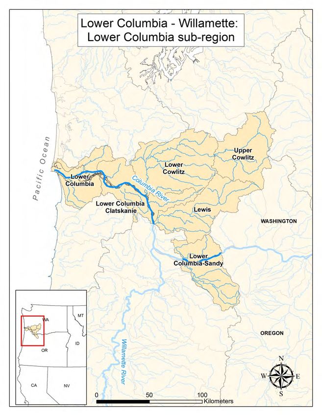
I.    Status and Distribution of Pacific lamprey in the RMU

   A. General Description of the RMU
        The Lower Columbia River sub-unit within the Lower Columbia River/Willamette Regional
        Management Unit includes watersheds that drain into the Columbia River mainstem from Bonneville
        Dam at Rkm 235, west to confluence of the Columbia River with the Pacific Ocean. It is comprised of
        six 4th field HUCs ranging in size from 1,753−3,756 km2 (Table 1). Watersheds within the Lower
        Columbia River sub-unit include the Lower Columbia-Sandy, Lewis, Upper and Lower Cowlitz, Lower
        Columbia-Clatskanie, and Lower Columbia River (Figure 1).

Figure 1. Map of watersheds within the Lower Columbia/Willamette RMU, Lower Columbia sub-unit.

                                                                                                          1
Lower Columbia sub-unit – Regional Implementation Plan                      August 12th, 2020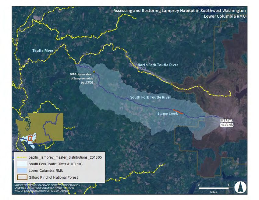
Table 1. Drainage Size and Level III Ecoregions of the 4th Field Hydrologic Unit Code (HUC) Watersheds
located within the Lower Columbia sub-unit.
                                   HUC         Drainage
 Watershed                        Number      Size (km2) Level III Ecoregion(s)

 Lower Columbia-Sandy             17080001         2,263     Willamette Valley, Cascades
 Lewis                            17080002         2,719     Puget Lowland, Willamette Valley,
                                                               Cascades
 Upper Cowlitz                    17080004         2,654     Puget Lowland
 Lower Cowlitz                    17080005         3,756     Puget Lowland, Cascades
 Lower Columbia-Clatskanie        17080003         2,349     Coast Range, Willamette Valley
 Lower Columbia                   17080006         1,753     Coast Range

B.       Status of Species
Conservation Assessment and New Updates
Current Pacific Lamprey distribution in the Lower Columbia sub-unit is greatly reduced from historical range
(Table 2). The revised Pacific Lamprey Assessment ranking of current distribution was reduced in all HUCs in
2017. The decline in these areas is a result of more accurately calculating the numeric area of occupancy
(versus using a visual estimate), rather than a decline in Pacific Lamprey range (USFWS 2018). Overall,
understanding of distribution has expanded considerably in many Oregon State tributaries due to increased
sampling effort (e.g., smolt trapping, redd surveys, occupancy sampling). Less is known about lamprey
distribution in Washington State tributaries. Existing information is largely based upon anecdotal observations,
or has been collected incidentally while monitoring salmonid species. A compilation of all known larval and
adult Pacific Lamprey occurrences in the Lower Columbia sub-unit are displayed in Figure 2, which is a
product of the USFWS Data Clearinghouse.
Pacific Lamprey population abundance was updated in the Lower Columbia-Sandy, Lower Columbia-
Clatskanie, and Lower Columbia River HUCs using new information from Oregon Department of Fish and
Wildlife (ODFW) to estimate a range of abundance using available redd counts. As part of the monitoring for
winter steelhead spawning populations, the Oregon Adult Salmonid Inventory and Sampling (OASIS) field
crews record data on lamprey spawners and redds. These estimates are considered minimum population
numbers, as the surveys are focused on steelhead, and end before the completion of Pacific Lamprey spawning
(see Jacobsen et al. 2014; Jacobsen et al. 2015; Brown et al. 2017). Abundance estimates were calculated for
four lower Columbia River tributaries in multiple run years: the Sandy River (2010, 2012-2016), Clatskanie
River (2012-2013, 2015-2016), Youngs Bay and Big Creek (2012-2013). Average abundance of adults ranged
from 2-293 fish in the Sandy Basin (avg. of avg. 97 fish), 157-782 fish in the Clatskanie River (avg. of avg. 408
fish), and 25-980 fish in Youngs Bay and Big Creek Combined (avg. of avg. 354 fish). Adult Pacific Lamprey
abundance is currently unknown in the Lewis and Lower Cowlitz HUCs, and Pacific Lamprey are believed to
be extirpated from the Upper Cowlitz River. The Cowlitz Salmon Hatchery Barrier Dam and Mayfield Dam

                                                                                                                2
Lower Columbia sub-unit – Regional Implementation Plan                           August 12th, 2020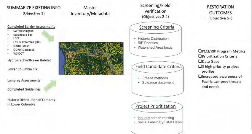
effectively block access to the upper portion of the Lower Cowlitz River (above RM 49.6) and upper Cowlitz basin.
Short-term population trend (defined as the degree of change in population size over 3 lamprey generations or 27 years), was ranked
as unknown in all HUCs of the Lower Columbia sub-unit (Table 2). Mainstem dam counts provide one of the only long term records
of adult Pacific Lamprey numbers in the Columbia River basin. Despite data gaps and monitoring inconsistencies, counts of adult
Pacific Lamprey at Bonneville Dam indicate a significant downward trend in abundance over time. Counts of adult Pacific Lamprey
prior to 1970 averaged over 100,000 fish (1939-1969), while the recent 10-year average is just over 34,000 fish (FPC 2019).
Historical harvest records at Willamette Falls also suggest a decline in adult Pacific Lamprey abundance. Harvest estimates have
ranged from a peak of ~400,000 pounds of fish in 1946 to less than 12,000 pounds since 2001 (Ward 2001). This reduction may be
attributable to reduced fishing effort, more stringent regulations, different harvest methods, or a decline in lamprey abundance
(Kostow 2002). Unfortunately no long term counts of Pacific Lamprey exist in tributary or mainstem areas of the Lower Columbia
sub-unit. Populations are believed to be declined (from historical levels), but adequate information does not exist to estimate the
magnitude of the decline. Oregon Department of Fish and Wildlife OASIS estimates provide 2-6 years of good abundance
information in select lower Columbia tributaries (i.e., Sandy, Clatskanie, Youngs Bay and Big Creek), but this data set is not long
enough to infer population trends.

Table 2. Population demographic and conservation status ranks (see Appendix 1) of the 4th Field HUC watersheds located within the
Lower Columbia sub-unit. Note – steelhead intrinsic potential was used as a surrogate estimate of historical lamprey range extent in
areas where historical occupancy information was not available. Ranks highlighted in yellow indicate a change from the 2011
Assessment.

                                  HUC         Conservation   Historical              Current           Population      Short-Term Trend
 Watershed                       Number       Status Rank Occupancy (km2)        Occupancy (km2)      Size (adults)       (% decline)
 Lower Columbia-Sandy           17080001          S2            1000-5000             100-500           50-1000            Unknown
 Lewis                          17080002          S1↓            250-1000             100-500          Unknown             Unknown
 Upper Cowlitz                  17080004          SH            1000-5000              Zero              Zero              Unknown
 Lower Cowlitz                  17080005          S2            1000-5000             100-500          Unknown             Unknown
 Lower Columbia-Clatskanie      17080003         S1S2↓          1000-5000             100-500          250-2500            Unknown
 Lower Columbia                 17080006          S2            1000-5000             100-500          250-2500            Unknown

                                                                                                                                       3
Lower Columbia sub-unit – Regional Implementation Plan                      August 12th, 2020
Figure 2. Current and historical known distribution for Pacific Lamprey: Lower Columbia/Willamette Regional Management Unit,
Lower Columbia sub-unit (USFWS Data Clearinghouse 2017). Historical Pacific Lamprey distribution depicted in map was obtained
from published literature, tribal accounts and state and federal agency records.
                                                                                                                            4
Lower Columbia sub-unit – Regional Implementation Plan                 August 12th, 2020
Distribution and Connectivity
Threats to passage were considered moderate in the Lower Columbia sub-unit (Table 3). While adult passage is
not impeded by dams of the Federal Columbia River Power System (FCRPS), lamprey in these HUCs are
affected by other large hydroelectric dam including Merwin, Swift, and Yale Dams in the Lewis Basin, and
Mayfield, Mossy Rock and Cowlitz Falls in the Lower and Upper Cowlitz Basins. These dams were built
without fish passage and completely block upstream migration and access to important spawning and rearing
habitat. To compensate for loss of passage, salmon and steelhead are diverted into a collection facility where
they are sorted, hauled by truck and released above dams. Downstream passage for juveniles is accomplished
using floating surface collectors. It is unknown whether Pacific Lamprey have ever been collected at Cowlitz
Salmon Hatchery or Merwin adult fish collection facilities. No trap-and-haul of lamprey currently takes place
above these dams. Other significant passage barriers in the Lower Columbia sub-unit include the multi-dam
complex on the Bull Run River in the Sandy basin, and Sediment Retention Structure on the North Fork Toutle
River. Culverts, tide gates, and small dams/weirs are also a concern throughout the RMU.
Road crossing culverts are prevalent in the Lower Columbia sub-unit. Poorly designed or installed culverts may
fragment aquatic habitat and impede the migration of fish. Culverts with excessive water velocity (>0.86 m/s),
inadequate attachment points, perched outlets, or added features with abrupt 90 degree angles (e.g., baffles, fish
ladder steps, outlet aprons), may obstruct passage of adult lamprey (Moser et al. 2002; Mesa et al. 2003; Keefer
et al. 2003; Stillwater Sciences 2014; Crandall and Wittenbach 2015; LTW 2020a). Many impassable culverts
occur low in watersheds (near tributary outlets), preventing access to miles of potential habitat. Barrier removal
projects are on-going throughout the Lower Columbia sub-unit, but more effort is needed to address the passage
needs of adult Pacific Lamprey and other native fish species (see LTW 2020a). There are still a number of
basins within the lower Columbia with no barrier assessments.
Tide gates are broadly distributed in tidally influenced tributaries of the Lower Columbia sub-unit. Estuarine
wetlands and floodplains were historically constrained by dikes and gated culverts to prevent flooding and drain
land for agriculture, livestock grazing, and/or residential development. Traditional top-hinge tide gates do not
allow tidal backflow and thus provide few (if any) passage opportunities for fish. Furthermore, many of the
older wood and cast iron tide gates have become damaged or corroded over time and need maintenance.
Stakeholder groups, like the Oregon Tide Gate Partnership, are actively working to facilitate the removal, repair
or replacement of failing structures throughout the Oregon Coast and Lower Columbia. The Nature
Conservancy recently funded a tide gate inventory of the lower Columbia that will be implemented in summer
2020.
Fish hatcheries in the lower Columbia River basin often utilize barrier dams and fish ladders to divert adult
salmon into the hatchery during brood collection, or to regulate fish passage above the hatchery. Many of these
structures are suspected passage barriers to adult Pacific Lamprey. The USFWS in partnership with ODFW
recently completed an evaluation of adult Pacific Lamprey passage efficacy at seven different fishways and
barrier dams associated with three salmon hatcheries in Oregon. A similar assessment is underway at 12 fish
hatcheries in SW Washington.
5
Lower Columbia sub-unit – Regional Implementation Plan August 12th, 2020C. Threats
Summary of Major Threats
The following table summarizes the known key threats (i.e., score ≥2.50) within the Lower Columbia sub-unit tributaries as identified
by RMU participants during the Risk Assessment revision meeting in May 2017. The highest priority threat in the Lower Columbia
watersheds is Dewatering and Flow Management followed by, Passage, Stream and Floodplain Degradation, and Water Quality.
Table 2. Key threats to Pacific Lamprey and their habitats within the Lower Columbia River sub-unit, 2017. High = 4;
Moderate/High = 3.5; Moderate = 3; Low/Moderate = 2.5; Low = 2; Unknown = no value
Stream and
Passage Dewatering and Floodplain Water Quality
Watershed Flow Management Degradation
Scope Severity Scope Severity Scope Severity Scope Severity
Sandy 2.5 3 3.5* 2 2.5 3 3* 3*
Lewis 3 3 4 4 3 3 3 3
Upper Cowlitz 4 4 4 4 3 3 1 1
Lower Cowlitz 3 3 3 4 3 3 1 2
Clatskanie 3.5 4 3* 3* 4 3 3.5* 3.5*
Lower Columbia 2 2.5 2.5 2 3.5 3 3 4
Mean 3.00 3.25 3.33 3.17 3.16 3.00 2.42 2.75
Rank M H M M M M L M
Mean Scope & 3.13 3.25 3.08 2.59
Severity
Drainage Rank M M M M
“*” indicates areas that were ranked higher because of the mainstem Columbia River
6
Lower Columbia sub-unit – Regional Implementation Plan August 12th, 2020Current Threats Dewatering & flow management Dewatering and Flow Management was ranked a moderate threat in the Lower Columbia sub- unit. Low seasonal streamflow and Bonneville Dam flow regulation were identified as key issues in the region. Low flow conditions occur naturally in many watersheds during summer months (e.g., Grays River), but land use practices and consumptive water use may exacerbate conditions further. Water withdrawals for irrigation, livestock, municipal, or industrial purposes leave many watersheds in the Lower Columbia sub-unit dewatered or with inadequate flow during summer and fall months (e.g., Sandy River, Washougal River, East Fork Lewis River, Kalama River, Clatskanie River, Lewis and Clark River, Youngs River, Big Creek, and the South Fork Klaskanine River). Low flows can impact fish by reducing spawning and rearing habitat availability, creating low water passage barriers, or impairing water quality. The projected rise in human population and anticipated effects of climate change (i.e., elevated ambient temperatures, decreased surface water availability, altered flow regimes), may increase the frequency, duration and intensity of low flow conditions the future. The mainstem Columbia River downstream from Bonneville Dam is susceptible to frequent fluctuations in discharge and water level resulting from the operation of Bonneville Dam for hydropower production and flood control. Flow regulation has significantly altered the natural flow patterns of the Columbia River (see Lower Columbia Fish Recovery Board (LCFRB) 2010). These changes can negatively impact aquatic species that rely on environmental cues (i.e., temperature, photoperiod, flow) to trigger important developmental or behavioral events such as emergence, growth, maturation or migration. In the Columbia River basin, the spring freshet takes place an average of two weeks earlier and flow volume is reduced from historical levels (LCFRB 2010; Naik and Jay 2011). Diminished spring flows may increase the duration of fish migration, potentially increasing exposure to predators and other threats. Additionally, the shift of peak flows to earlier in the spring could result in even longer periods of low flow and warm water temperatures during summer and fall months (Naik and Jay 2011). Rapid water level fluctuations below Bonneville Dam (i.e., hydropeaking) repeatedly inundate and dewater shallow water areas, directly impacting the quantity, accessibility and suitability of spawning and rearing habitat. Lamprey larvae are especially vulnerable to stranding as they rear in fine sediments along river margins and delta regions, but impacts related to hydropeaking below Bonneville Dam are unknown (Jolley et al. 2012; Mueller et al. 2015). Stream & floodplain degradation Stream and Floodplain Degradation was also ranked a moderate threat. Channel confinement, channel manipulation, and floodplain development are the primary concerns in the sub-unit. Human settlement and land development have greatly altered the physical habitat of tributaries in the region. In upland areas, stream cleaning, forest fires (e.g., Yacolt Burn), and historical timber harvest practices have completely deforested or altered the diversity and age structure of riparian vegetation and trees. Many watersheds are lacking mature trees that play a pivotal role in bank stability, water quality protection, thermal cover, and input of wood into channels. Large wood can benefit streams by influencing the structural complexity of the channel (i.e., creating Lower Columbia sub-unit – Regional Implementation Plan August 12th, 2020 7
pools or undercut banks), increasing the deposition of fine substrate and organic matter, thereby
providing important rearing habitat for juvenile salmonids and larval lamprey (Gonzalez et al.
2017). Within lowland areas, river channels have been straightened, diked and armored to
protect property against flooding and erosion. Channel simplification and conversion of land for
agriculture, grazing, and development (rural, urban, commercial, industrial) has reduced or
eliminated a substantial amount of side channel and wetland habitat.
The Columbia River mainstem below Bonneville Dam has been straightened and confined by
major railroad and transportation corridors that run parallel to the river. Much of the shoreline is
armored with riprap and connection to tributaries occurs through culverts and bridges. In the
Lower Columbia River and estuary, dikes and levees have disconnected the mainstem from
floodplain and estuary habitat (e.g., tidal swamp, marsh, wetlands), reducing the river to a single
channel. Efforts to maintain the shipping channel (e.g., jetties, pile dikes) have altered flow
patterns and increased sediment accumulation that requires periodic dredging to remove. The
impacts of channel maintenance dredging on larval lamprey in the Lower Columbia River have
not been thoroughly documented. Dredging may displace, injure or kill burrowing larvae,
disturb or destroy potential rearing habitat, or re-suspend contaminated sediments into the river
(Maitland et al. 2015; Clemens et al. 2017). Preliminary deep water larval sampling in the
Lower Columbia River downstream from the City of Skamakawa (RM 33.5) did not detect larval
lamprey in the 15 quadrats surveyed (Jolley et al. 2011a). Multiple size class and species of
lamprey have been observed in other areas within the Columbia River mainstem (Jolley et al.
2011b; Jolley et al. 2012), but habitat use and distribution within the estuary is still unknown.
Water quality
Elevated water temperature is the primary water quality concern in Lower Columbia tributaries.
Excessive temperatures generally occur during summer months and may be attributed to
increased air temperature, lack of riparian cover, reduced instream flows associated with water
withdrawal, and warm irrigation water returns. The impacts of relatively warm water
temperatures (e.g., ≥20°C) on Pacific Lamprey embryonic development, physiology, adult
migrations, reproductive capability and evolutionary pressures can be multitudinous and
substantial (Clemens et al. 2016). Other water quality concerns in tributaries include low
dissolved oxygen, pH extremes, and presence of bacteria (e.g., fecal coliform, e coli), that may
be associated with elevated water temperatures and agricultural or urban runoff.
Major water quality concerns in the Lower Columbia mainstem include elevated water
temperature, low dissolved oxygen, gas supersaturation, and biological and chemical
contaminants. Average water temperature below Bonneville Dam often exceeds 19°C in late
June to early September (Bragg and Johnston 2016). High water temperatures are likely a result
of warmer ambient temperatures and cumulative effects of water withdrawal and land use
activities in tributary and mainstem areas. Dissolved gas supersaturation resulting from spill
from Bonneville Dam can exceed the EPA mandated limit of 110% saturation for several months
during normal and low water years (Schneider and Barko 2006). These levels may extend
throughout the entire lower Columbia River. Short-term exposure to gas levels
habitats or exposed during vulnerable life stages (e.g., incubating embryos, sac fry, or larvae)
may be more sensitive to sublethal effects. The vulnerability of Pacific Lamprey to gas bubble
disease or potential sensitivity at different life stages is unknown. Industrial discharge and
surface water runoff from farms, roads and urban areas are the primary source of contaminants
entering the Columbia River mainstem. Toxic contaminants such as DDE, PCBs, and heavy
metals settle out and accumulate in fine sediments, reaching concentrations that may be harmful
to aquatic and terrestrial organisms. Toxins and heavy metals may be a particular concern for
Pacific Lamprey because direct exposure in water or sediment during larval and adult life stages
can result in high concentrations of contaminants accumulating in fatty tissues that may
compromise fish health and development (Nilsen et al. 2015; Clemens et al. 2017). Monitoring
and restoration efforts to improve and protect water quality for fish, wildlife, and human health
are ongoing in the Lower Columbia sub-unit.
Predation
Although not ranked a ‘key threat’, predation of adult and juvenile lamprey by native and non-
native fish, birds, and marine mammals is known to occur in the Columbia River Basin (Close et
al. 1995; Zorich et al. 2011; Madson et al. 2017). Pacific Lamprey encounter many of the same
predators as salmonids during migration, but the severity of the threat is not well understood.
Dams and other human changes to the environment can increase habitat suitability for predator
species and may contribute to the decline of lamprey by delaying/slowing migration or exposing
fish to increased mortality in areas where piscivorous predators may congregate (e.g. Bonneville
Dam tailrace, Sand Island, etc.). In addition, temperature increases predicted with climate
change models may expand the territory of warmwater predators into tributaries, putting further
stress on native fish communities (Lawrence et al. 2014).

Restoration and Research Actions
To date, the primary lamprey restoration activities that have occurred or are occurring within this
RMU are being performed by organizations focused on salmon and steelhead recovery on both
the Oregon and Washington side of the river. Many instream and floodplain habitat restoration
activities have been identified in subbasin and watershed management plans (e.g., Oregon Lower
Columbia River Conservation and Recovery Plan (2010), Washington Lower Columbia Salmon
Recovery and Fish and Wildlife Subbasin Plan (2010), Lower Columbia River Recovery Plan for
Salmon and Steelhead (2013)). The vast majority of these actions have been funded and
designed for salmon recovery, but work may improve habitat conditions for lamprey as well.
Current Pacific Lamprey research has focused on gaining a better understanding of distribution
and habitat use within the Columbia River mainstem and tributaries. The following lamprey
research and restoration actions were initiated or recently completed by RMU partners in the
Lower Columbia sub-unit from 2012-2019.

Lower Columbia sub-unit – Regional Implementation Plan                 August 12th, 2020        9
HUC          Threat        Action Description                               Type            Status

RMU          Population    Environmental DNA, spawning ground               Survey          Ongoing
                           surveys, smolt trapping and occupancy
                           sampling to better understand lamprey
                           distribution.
RMU          Stream        Implementation of instream and floodplain        Instream        Ongoing
             Degradation   habitat restoration activities and culvert
                           removal/replacement projects where lamprey
                           salvage efforts occurred.
RMU          Passage       Evaluation of adult Pacific Lamprey passage      Assessment      Underway
                           efficacy at fishways and barrier dams
                           associated with salmon hatcheries.
RMU          Population    Distribution surveys in mainstem and             Survey          Ongoing
                           principal tributaries
RMU          Population    Use of eDNA to monitor effectiveness of          Assessment      Proposed/
                           large wood placement projects and                                Underway
                           recolonization of larval lamprey following
                           restoration
RMU          Lack of       Consideration of lamprey when planning and       Coordination    Ongoing
             Awareness     implementing instream habitat restoration
                           work (see LTW 2020b)
RMU          Lack of       Compilation of lamprey data from SW              Assessment      Complete
             Awareness     Washington tributaries
RMU          Passage       Map, assess and prioritize passage barriers in   Assessment      Proposed
                           tributaries and evaluate available lamprey
                           habitat upstream
RMU          Population    Adult/Juvenile Pacific Lamprey abundance         Assessment      Underway
                           data summary for Southwest Washington
                           tributaries
RMU          Population    Oregon Department of Fish and Wildlife           Other           Complete
                           Conservation Plan for Lampreys in Oregon
                           https://www.dfw.state.or.us/fish/CRP/coastal_
                           columbia_snake_lamprey_plan.asp
RMU          Population    Ongoing lamprey genetics work (CRITFC)           Assessment      Ongoing
Sandy        Stream        Sandy River floodplain reconnection, gravel      Instream        Complete
             Degradation   augmentation in Bull Run River.
Sandy        Stream        Large wood augmentation, side channel            Instream        Complete
             Degradation   reconnection in upper Sandy River.
Clatskanie   Population    Conduct adult spawning ground surveys to         Survey          Ongoing
                           monitor Pacific Lamprey distribution, timing,
                           and number of redds to develop relative
                           abundance indexes.
Clatskanie   Population    Deep water sampling to document distribution     Assessment      Complete

         Lower Columbia sub-unit – Regional Implementation Plan                August 12th, 2020       10
and habitat use of larval lamprey in Columbia
River mainstem.
Clatskanie Passage Tide gate and culvert modification and Instream Ongoing
removal projects to restore access to
spawning and rearing habitat.
Clatskanie Stream Assessment of larval lamprey use in areas of Survey Underway
Degradation salmonid restoration vs no restoration
(Abernathy Creek).
Lower Stream Floodplain reconnection on Lewis and Clark Instream Upcoming
Columbia Degradation & junctions of Big and Little Creeks
Lower Passage Pilot test of acoustic telemetry array to Instream Upcoming
Columbia monitor movement of juvenile lamprey
Lower Passage Lamprey friendly passage improvements at 3 Instream Underway
Columbia dams at North Fork Klaskanine Hatchery
Lower Passage Evaluation of passage constraints for lamprey Instream Underway
Columbia at fish hatcheries in Washington State
Lower Population Conduct adult spawning ground surveys to Survey Ongoing
Columbia monitor Pacific Lamprey distribution, timing,
and number of redds to develop relative
abundance indexes.
Lower Population Pilot project to evaluate catchability of Survey Proposed
Columbia western river lamprey in coastal estuaries
Lower Passage Tide gate and culvert modification and Instream Ongoing
Columbia removal projects to restore access to
spawning and rearing habitat.
Lower Population Investigation of salinity tolerance and larval Assessment Complete
Columbia lamprey occurrence in tidally influenced
estuarine stream.
Lower Passage Formation of Oregon Tide Gate Partnership Coordination Ongoing
Columbia Group
Lower Passage Tide gate inventory in lower Columbia River Survey Underway
Columbia
Lower Columbia sub-unit – Regional Implementation Plan August 12th, 2020 11II. Selection of Priority Actions A. Prioritization Process Participating members of the Lower Columbia sub-unit had a virtual meeting on April 23rd, 2020 to discuss completed and ongoing conservation actions and identify specific projects and research needed to address threats and uncertainties within the region. The following projects were submitted by RMU partners for the Lower Columbia sub-unit Regional Implementation Plan in 2020: • Lower Columbia Pacific Lamprey Barrier Evaluation and Project Prioritization • Assessing and Restoring Lamprey Habitat in Southwest Washington Lower Columbia sub-unit – Regional Implementation Plan August 12th, 2020 12
B. High Priority Proposed Project Information

Project Title: Lower Columbia Pacific Lamprey Barrier Evaluation and
Project Prioritization

Project Applicant/Organization: Lower Columbia River Watershed Council (LCRWC)
Contact Person: Allan Whiting, Watershed Council Coordinator

Email: allan@whitingenv.com

Phone: 503.789.9240

Project Type: Assessment

Lamprey RMU population(s): Lower Columbia Sub-Region
Multi-RMU project? No

Watershed (5th HUC Field):
NPCC Subbasin (4th HUC Field) name:
 Watershed                 HUC Number

 Lower Columbia-Sandy          17080001
 Lewis                         17080002
 Upper Cowlitz                 17080004
 Lower Cowlitz                 17080005
 Lower Columbia-Clatskanie     17080003
 Lower Columbia                17080006

Project Location: Regional in extent
Project Coordinates (latitude and longitude, decimal degrees, NAD 1983): N/A

Total Requested funds: $56,309
    1. Short Project Summary (200 words or less):
The overarching goal of this project is to restore Pacific Lamprey access to blocked high-quality
habitats in the Lower Columbia region. This will be accomplished by inventorying and assessing
potential barriers to lamprey, prioritizing sites for providing passage, and recommending passage
solutions for high priority sites. These tasks will follow existing passage guidance documents
and be conducted in collaboration with a Technical Advisory Committee (TAC) of restoration
practitioners, regional habitat restoration programs, State and Federal biologists, and the
Lamprey Technical Workgroup (LTW). The Lower Columbia River Watershed Council
(LCRWC) will convene the TAC and coordinate with the LTW and local restoration groups. Key
project outcomes will include (1) a comprehensive spatial database of potential barriers to
lamprey in the region that will be shared with the Pacific Lamprey Conservation Initiative
(PLCI) and other stakeholders; (2) lists of identified barriers and sites that require further
assessment, prioritized by upstream habitat potential; and (3) conceptual approaches for
Lower Columbia sub-unit – Regional Implementation Plan                August 12th, 2020       13
providing passage at high priority barriers that have been vetted for project feasibility by
LCRWC in coordination with the TAC and local restoration organizations. An additional benefit
is increased awareness of Pacific Lamprey passage and habitat requirements in the region that
will encourage multi-species restoration.
2. Detailed Project Description (500 words or less):
Objective #1: Inventory potential barriers to Pacific Lamprey in Study Area
The LCRWC will work with TAC and consultant team with GIS and lamprey expertise to
develop a comprehensive inventory of barriers to Pacific Lamprey in a focal Study Area. A 4th
Field HUC within the RMU will be selected as the Study Area in consultation with TAC based
on relative severity of passage as a threat, data quality, and transferability to this process. The
inventory will collate existing barrier databases and completed barrier assessments. Results will
be included in a geodatabase to support landscape-scale analyses informing site selection and
prioritization for passage evaluation (Objective #2). Site-specific information from existing
salmonid-focused assessments will be included in database and used to support both
prioritization and determination of barrier status for lamprey (#3).
Deliverable: Comprehensive geodatabase of potential barriers in Study Area compatible with
existing formats (e.g., Databasin.org, PacificLamprey.org).
Objective #2: Prioritize potential barriers for evaluation of lamprey passage
The inventory will undergo initial screening to omit sites outside Pacific Lamprey predicted
historical distribution, as well sites that are clearly not barriers based on information from
Objective 1. Remaining sites will be prioritized for evaluation based on upstream habitat
potential, access constraints, and stakeholder input. The PLCI Regional Implementation Plan
(Poirier 2019) will also inform prioritization.
Deliverable: Prioritized list of sites requiring Pacific Lamprey passage evaluation.
Objective #3: Determine lamprey passage status at priority sites
Protocols from the LTW (2020) will be applied to assess passage status of priority sites. In some
cases, passage status will be determined remotely, but field assessments will be conducted at
some sites. Data and observations from field assessments will inform both feasibility and
prioritization (#4) and solutions for providing passage at barrier sites (#5).
Deliverable: List of sites that are non-barriers, total barriers, partial barriers, or require further
evaluation. Site data will be included in geodatabase.
Objective #4: Project Prioritization
Barrier sites from Objective 3 will be prioritized for passage project development using factors
such as:
• extent to which site is a barrier (i.e., total or partial/seasonal),
• relative quality of upstream habitat,
• extent to which providing passage would benefit other aquatic species,
• benefits to downstream habitat by restoring geomorphic processes and wood transport,
• relative cost and feasibility of providing passage.
Lower Columbia sub-unit – Regional Implementation Plan August 12th, 2020 14The prioritization process will be developed in consultation with the TAC and will likely apply
an objective scoring-and-ranking approach or decision-support tool. Importantly, the preliminary
project list will be vetted for feasibility with local restoration groups.
Deliverable: Prioritized list of barrier sites in the Study Area
Objective #5: Develop conceptual options for providing passage at high priority sites.
Project concepts and approaches for providing passage will be developed for highest priority
sites identified from Objective 4. Potential options for providing passage will be developed for a
minimum of three (3) high priority sites in coordination with TAC and local stakeholders.
Resulting project concept profiles will include conceptual-level descriptions of passage solutions
and outline steps needed to finalize and implement designs at each site.
Deliverables:
• Report summarizing the process and results of Objectives #1-5
• Project concept profiles for high priority sites for next step implementation funding and
assessing preliminary regulatory requirements.
3. Descriptive Photographs-Illustrations-Maps (limit to three total):
Workflow model is provided below to show initial logic to proposed objectives and
restoration outcomes for the Lower Columbia RMU and broader PLCI.
4. Linkage of Actions to Identified Threats for Lampreys in RMU(s) (300 words or less):
• What threat(s) to lampreys does this project address? (See your RIP(s) for key
threats) Passage , Stream and Floodplain Degradation, Lack of Awareness
• Does this project address threat(s) to lampreys specific to this RMU only, or does
the project address the threat(s) prevalent in multiple RMUs?
Single RMU ☒, Multiple RMUs ☐ list additional RMUs:
Lower Columbia sub-unit – Regional Implementation Plan August 12th, 2020 15Lower Columbia RMU is focus area, though process may be adopted to address threats
elsewhere in the region.
• Describe how this project addresses key threat(s) to lampreys within the HUC(s)
where project is proposed.
The lack of habitat connectivity and access to lamprey habitat is a threat consistently
documented across multiple HUCs in the Lower Columbia RMU. Several watershed
areas have been highlighted in the Regional Implementation Plan (RIP) offering insight
into sub-areas to focus on within the RMU. Road crossings that block lamprey passage
are present throughout the RMU. These artificial barriers limit natural migration patterns
for adult lamprey. Many of these structures also impact sediment and wood transport,
impacting habitat quality for both larval and adult lamprey. Guidance documents
completed offer a platform for field investigations to better understand not only condition
of these barriers, but their constraints on broader stream and floodplain habitat forming
processes. Project addresses these threats through the evaluation of structures blocking
the greatest amount of lamprey habitat and developing passage solutions at high priority
sites. A list of prioritized structures for modification and/or removal will be major
outcome of this project. The list can be adopted by regional entities and local
organization for future proposal development, design, and implementation.
5. Species/Habitat Benefits (200 words or less
• Provide citation of literature, distribution maps, and/or surveys demonstrating
lampreys are currently and/or were historically present in the project area.
How will the project provide meaningful measurable results to improve
lamprey populations and/or their habitat conditions?
• What life stage or stages will benefit from action? How?
• What other species may benefit from action?
Distribution layers from the PLCI Pacific Lamprey Data Clearinghouse, as well as
published literature and tribal accounts indicate that Pacific Lamprey are currently found
throughout accessible portions of the study area.
https://www.sciencebase.gov/catalog/item/imap/5745f81fe4b07e28b662c6ee.
Identifying and removing passage barriers to allow migrating adults access to historical
habitats is one of the most tangible and cost-effective ways to increase the lamprey
population. By identifying barriers that block the most habitat and that are most feasible
to remove, the proposed project accomplishes necessary steps towards improving the
lamprey population in the study area. By leading to projects that provide passage for
migrating adults into reaches with holding, spawning, and rearing habitats, this project
benefits all freshwater life stage of the species.
While this project is focused on identifying barriers to Pacific Lamprey passage, the
comprehensive inventory of potential barrier for the study area can be used for passage
assessments of other species. Moreover, level of benefit to other species will be a key
consideration when prioritizing and recommending barrier for removal. Passage solutions
that provide unimpeded passage for all native aquatic species, such as the Stream
Simulation Design approach will be given precedence in our recommendations where
feasible.
Lower Columbia sub-unit – Regional Implementation Plan August 12th, 2020 166. Priority Objectives and Goals:
• Indicate the strategies, and/or restoration/management plans are addressed by this
project (when available relevant documents/websites are hyperlinked below for
reference):
o PLCI Conservation Agreement ☒
o National Fish Habitat Partnership National Conservation Strategies ☒
o USFWS Climate Change Strategies ☐
o Bonneville Power Administration Northwest Power and Conservation
Council Columbia River Basin Fish and Wildlife Program ☒
o CRITFC Tribal Pacific Lamprey Restoration Plan for the Columbia
River Basin ☒
o US Army Corps of Engineers Pacific Lamprey Passage Improvement
Implementation Plan ☐
o PUD Management Plan (please name below) ☐
o Other (please name below) ☒
Lower Columbia Regional Implementation Plan (USFWS, 2019)
Coastal, Columbia, and Snake Conservation Plans for Lampreys in
Oregon (ODFW.2020)
PLCI Conservation Agreement and Lower Columbia RIP
Below are the following PLCI objectives and description that this proposal will attain,
Objective 3: Public Outreach
Working with project practitioners and local organizations will build capacity in the
region for community groups to improve understanding habitat requirements of
pacific lamprey. Participation in the process will give them the tools needed to
develop projects and associated outreach in alignment with needs of the community
Objective 4: Data sharing
Information will be made available to all participants and their partners including
summary geodatabase and documentation of the process.
Objective 6: Identify, secure and enhance watershed conditions contained in the
RMUs. Protect areas with healthy habitat conditions and strive to improve watershed
conditions and migratory corridors where needed. Specifically:
• Objective 6 a) Project leads to identification of high value project opportunities
and restoration options for local sponsors to consider for future design and
implementation phases.
• Objective 6 b) In project will identify design elements necessary to support all life
stages of Pacific Lamprey.
• Objective 6 c) This may in some cases expand benefits for project areas already
considered by project sponsors for salmon.
• Objective 6 e) Candidate areas may also serve as monitoring site for program
project effectiveness and/or status monitoring.
Lower Columbia sub-unit – Regional Implementation Plan August 12th, 2020 17Lower Columbia sub-unit-Regional Implementation Plan
Project addresses threats and implements actions cited in the region’s RIP.
• Summary of Major Threats, Table 2 (p.6): Passage, Stream and
Floodplain Degradation.
• Restoration and Research Actions: Map, assess, and prioritize passage
barriers in tributaries and evaluate available lamprey upstream (p.10)
NWPCC-2014 Fish and Wildlife Plan
Strategies from completed 2014 Fish and Wildlife Plan for the Columbia basin were
identified along with emerging goals from 2020 addenda. Applicable references are
as follows:
IV Strategies-Lamprey-Mainstem and tributary habitat
The action agencies, in coordination with agencies and tribes, shall:
o Implement instream habitat projects in a manner that minimizes
mortality to lamprey by consulting the Best Management Practices for
Pacific Lamprey
o Continue to identify, protect, and restore habitat areas and ecological
functions, such as stream channel complexity and function, that are
associated with productive spawning, resting, rearing, and migrating
lamprey
o Install appropriate and effective juvenile lamprey screening for
tributary water diversions
2020 Addendum to 2014 Fish and Wildlife Plan (draft goals)
Reduce the risk of extirpation and improved adult abundance toward sustainable
harvestable levels across the historic distribution and range of Pacific Lamprey in
the Columbia basin, including across all six Pacific Lamprey Regional
Management Units (RMU), measured every five years.
CRITFIC-Tribal Pacific Lamprey Restoration Plan for the
Columbia River Basin
Objective 2: Improve tributary passage and identify, protect, and restore tributary
habitat
Action 4.2.1 Tributary Passage
a. Implement structural and operational changes within
tributaries to improve adult passage b. Implement
structural and operational changes within tributaries to
improve juvenile passage
Coastal, Columbia, and Snake Conservation Plans for
Lampreys in Oregon (ODFW)
Recently completed Conservation plan by State of Oregon identifies the following
threats and management priorities this project intends to contribute to:
• #1 Limiting factor-access (passage and screening at artificial
obstructions, p. 46)
Lower Columbia sub-unit – Regional Implementation Plan August 12th, 2020 18• Management Priority #1 Education and Outreach-Partner with
interested entities and individuals on sharing information about
lampreys and providing training; Remain active and engaged in the
Lamprey Technical Workgroup (p. 55)
• Management Priority #2-Passage and Screening (Table 6.1, p.52)-
Develop and use protocols to prioritize artificial obstructions for
passage and screening improvements
Management Priority #3-Protect and restore habitat (p.56)-Work with
habitat restoration implementers to complete or update watershed
assessments and increase restoration activities in lower mainstem
rivers and estuaries that may benefit anadromous lampreys
7. Project Design / Feasibility:
• Have the designs for the project been completed already or will they be completed
before planned project implementation? N/A
• Are the appropriate permits (e.g., ESA consultation, Scientific Collection, fish
health/transport, etc.) in place already or will they be in place before planned
project implementation? N/A
• Can the project be implemented within the defined timeframe? (See BPA &
NFHP requirements in the accompanying PLCI RIP Priority Project Guidance
document). Yes ☒ No☐
• Please provide a brief description (200 words or less):
8. Partner Engagement and Support (200 words or less):
• What partners are supporting the project?
Representatives from regional and local entities conducting restoration in the area have
expressed support for this project. Discussions with SRFB lead entity for the State of
Washington, Oregon local watershed councils, Conservation Districts, and USFWS and
ODFW research staff has justified the need for passage assessment leading towards a
multi-species passage restoration process that builds off previous efforts and ensures
consistency with current restoration initiatives.
• What partners are active in implementing the project?
Watershed Council will establish a project Technical Advisory Committee to ensure
input from representative groups in the region. Additional space will be created to ensure
diversity of communities including Native American organizations.
• What partners are providing matching funds or in-kind services that directly
contribute to the project?
Commitments have been secured for participation in the project TAC providing in-kind
services for time spent attending meetings, providing assessment documentation,
landowner outreach, and fieldwork support.
9. Monitoring and Reporting (200 words or less):
• How is completion of the project going to be documented? (See BPA and NFHP
requirements in the accompanying PLCI RIP Project Proposal Guidance
document).)
Lower Columbia sub-unit – Regional Implementation Plan August 12th, 2020 19Project deliverables include a technical memo to articulate process and methodology used
to prioritize sites for lamprey barrier removal and/or passage improvements and to
describe passage solutions for viable, high-priority projects.
• How will the project’s benefits to lampreys be monitored over time?
Candidate site for passage restoration identified through this project will be
recommended to regional State, Federal, and Tribal biologists permitted to conduct
lamprey surveys to help monitor project effectiveness (pre- and post-implementation
surveys).
10. Project Budget (including overhead):
The Project Budget is provided in the table below. If insufficient program funding is
available to fund each Proposed objective, the budget for this stepwise project can be
easily be broken into discrete smaller phases in coordination with the PLCI and funding
agency.
Lower Columbia sub-unit – Regional Implementation Plan August 12th, 2020 20Project Budget Table:
RIP Funds
# Hours Cost per Cost Share Total Cost
Items Requested
or Units Unit ($) ($) ($)
($)
A Personnel: - - - - -
a. Watershed
Council
Coordinator 270 50.00 13,500 3,500 17,000
b. Consultant
Service Contract 37,000 37,000
c. Technical
Advisory
Committee (6
representatives @
36 hours each) 324 50 11,232 11,232
Equipment &
- - - - -
B Supplies:
a. ArcView
License $1,000 1,000
b.
c.
d.
C Travel: - - - - -
a. Logistical
support for field
investigations 1200 @$.575/miles 690 690
D Other: - - - - -
a.
b.
E Administrative: - - - -
Overhead ( 10
%) 5,119 5,119
Indirect Costs (
%)
Total (Sum of A -
- -
E) $56,309 $15,732 $72,041
Lower Columbia sub-unit – Regional Implementation Plan August 12th, 2020 2111. Timeline of major tasks and milestones:
Workflow Start Date End Date Responsible Party
Objective 1: Inventory LCRWC, TAC,
February 1, 2021 April 30, 2021
potential barriers Consultant Team
Objective 2: Prioritize October 30, Project TAC,
April 15, 2021
potential barriers 2021 Consultant Team,
Objective 3: Determine
lamprey passage status at LCRWC,
November 15, 2021 March 30, 2021
priority sites Consultant Team
Objective 4: Project
LCRWC, TAC,
Prioritization April 15, 2021 June 15, 2021
Consultant Team
Objective 5: Develop November 30, LCRWC,
August 1, 2021
conceptual options 2021 Consultant Team
LCRWC,
Final Reporting January 1, 2022 March 30, 2022
Consultant Team
12. References:
Lamprey Technical Workgroup. 2020. Barriers to adult Pacific Lamprey at road crossings:
guidelines for evaluating and providing passage. Original Version 1.0, June 29, 2020. 31 pp. +
Appendices. Available: https://www.fws.gov/pacificlamprey/LTWGMainpage.cfm.
Poirier, J. 2019. Pacific Lamprey 2019 Regional Implementation Plan for the Lower
Columbia/Willamette Regional Management Unit Lower Columbia Sub-Unit. Submitted to the
Conservation Team August 27th, 2019. 30 pp.
Lower Columbia sub-unit – Regional Implementation Plan August 12th, 2020 22Project Title: Assessing and Restoring Lamprey Habitat in Southwest Washington
Project Applicant/Organization: Cascade Forest Conservancy
Contact Person: Shiloh Halsey
Email: shiloh@cascadeforest.org
Phone: 503-258-7774
Project Type: Habitat Restoration
Lamprey RMU population(s): Lower Columbia Sub-Region
Multi-RMU project? Please list RMUs
Lower Columbia, Mid-Columbia
Watershed (5 HUC Field):
th
Wind River (1707010510)
South Fork Toutle River (1708000506)
NPCC Subbasin (4 HUC Field) name:
th
Middle Columbia-Hood (17070105)
Lower Cowlitz (17080005)
Project Location: South Fork Toutle River (Stump Creek), Upper Wind River Watershed
(Panther Creek + Pete Gulch)
Project Coordinates (latitude and longitude, decimal degrees, NAD 1983):
Stump Creek (46.21860, -122.35369)
Panther Creek (45.83303, -121.87062)
Pete Gulch (45.98568, -121.88271)
Total Requested funds: $56,814
1. Short Project Summary (200 words or less):
Aquatic restoration techniques like instream wood placement, beaver reintroduction, and beaver
dam analogues (BDAs) hold great promise as methods to improve Pacific lamprey habitat. In
order to better understand and quantify these impacts on lamprey while also working to build
quality habitat and create aquatic ecosystems that are complex and resilient to the impacts of
climate change, the Cascade Forest Conservancy is seeking funds for our “Assessing and
Restoring Lamprey Habitat in Southwest Washington” project. Our goals are to install beaver
dam analogues, reintroduce beavers, and collect wood for future instream placement in
tributaries of two high priority stream systems: the South Fork Toutle River and the Wind River.
During the grant period we intend to install one BDA series containing 4-6 structures in the
South Fork Toutle watershed, and reintroduce 3-4 beaver families in the Wind River watershed.
In addition, we will assess lamprey presence and sample for Type I lamprey habitat pre- and
post-project. These actions will enhance existing lamprey habitat, expand current habitat to
upstream tributaries, and will also gather important on-the-ground information to improve future
efforts to restore and protect lamprey habitat in the region.
Lower Columbia sub-unit – Regional Implementation Plan August 12th, 2020 232. Detailed Project Description (500 words or less): The overall goals of our project are to improve habitat for Pacific lamprey while furthering our understanding of how instream restoration (either in the form of beaver dams, beaver dam analogues, or wood structures) will impact the current and potential spawning and rearing habitat for lamprey. Implementing these targeted restoration projects can reduce the key threats that lamprey face in the Lower Columbia Sub-Region. The colonization of beavers and/or the placement of wood structures and BDAs has the potential to positively impact the current lamprey populations in and around the Wind River and South Fork Toutle River. Our project has three objectives: 1) monitor lamprey and their habitat (pre- and post-project implementation), 2) restore and expand lamprey habitat, and 3) develop and implement a public outreach effort. It is well known that there is a dearth of knowledge about the current distribution of lamprey species. Therefore it is necessary for us to conduct extensive monitoring at our projects sites pre- and post-restoration. We will survey larval lamprey distribution in Type 1 habitat to provide baseline data for post-project monitoring. Due to the small size of our streams of interest, larval lamprey presence/absence will be conducted using Surber stream bottom sampler methods proposed by Lasne et. al. 2010. If the Surber sampler method proves ineffective, we will solicit help from PLCI and other lamprey specialists to conduct electrofishing surveys. We will collect presence/absence data on larval lamprey in the Wind River tributaries of Panther Creek and Pete Gulch, and Stump Creek, a tributary of South Fork Toutle River. Habitat assessments will help us identify reaches that lack sedimentation for spawning, reaches that have been channelized or scoured and/or reaches lacking instream wood. This is an important step in identifying priority locations for current and future restoration. By placing beavers, BDAs, and wood structures into the streams, we hope to improve channel complexity to enhance current habitat and expand future habitat for the health and resilience of local lamprey populations. We will release three to four families of beaver (3-6 beavers per family) to create more Type 1 habitat for lamprey in the Wind River watershed. In Stump Creek, we will install a series of beaver dam analogues to enhance the habitat for the current lamprey populations. To support critical efforts to build instream habitat in this reach, we will also be collecting and storing non-merchantable trees for future instream wood placement work that will be carried out after the project conclusion by LCFEG. As an organization, we offer educational volunteer trips to the local community. For this project, we will utilize volunteers to help with the monitoring that will occur pre- and post-project implementation. Community members will have the opportunity to engage in a conservation project while learning the interesting life history, biology, and cultural importance of lamprey. Lower Columbia sub-unit – Regional Implementation Plan August 12th, 2020 24
3. Descriptive Photographs-Illustrations-Maps (limit to three total):

Lower Columbia sub-unit – Regional Implementation Plan              August 12th, 2020   25
4. Linkage of Actions to Identified Threats for Lampreys in RMU(s) (300 words or less):
         • What threat(s) to lampreys does this project address? (See your RIP(s) for key
            threats) Water Quality Stream and Floodplain Degradation Dewatering &
            Stream Flow Management Choose an item.
         • Does this project address threat(s) to lampreys specific to this RMU only, or does
            the project address the threat(s) prevalent in multiple RMUs?
            Single RMU ☐, Multiple RMUs ☒ list additional RMUs: Mid-Columbia RMU
         • Describe how this project addresses key threat(s) to lampreys within the HUC(s)
            where project is proposed.

      Elevated water temperature is the greatest concern related to water quality for lamprey in
      the Lower and Mid-Columbia sub-regions. Beaver dams and BDAs can lower stream
      temperatures by creating deep pools and increasing groundwater storage (hyporheic
      exchange). Additionally the presence of beaver can increase riparian vegetation thus
      creating more stream shade (Pollock et. al. 2007; Weber et. al. 2017).

Lower Columbia sub-unit – Regional Implementation Plan               August 12th, 2020        26
The potential negative effects from climate change is of great concern for the Mid-
Columbia sub-region. Beavers and BDAs can increase resilience to climate change by re-
establishing important processes like increasing channel complexity, creating
in-stream habitat for a variety of species, stabilizing hydrologic regimes, and capturing
fine sediment (Pollock et. al. 2014).
Stream and floodplain degradation and dewatering & stream flow management are of
moderate concern for lamprey in the Lower and Mid-Columbia sub-regions. Decades of
channel manipulation, removal of woody debris, forest fires, lava flows, and antiquated
timber harvest methods have oversimplified streams within this region. Reintroducing
beavers and installing BDAs can reverse some of these negative effects and can benefit
streams by enhancing the stream complexity, creating deep pools, and shifting the stream
bed compositions from coarse to finer sediments (Pollock et. al. 2007), all of which are
preferred by larval lamprey (Roni 2003, Gonzalez et al. 2017).
Low flows can affect the spawning and rearing habitat that is available for lamprey. We
expect climate change to cause low flows to occur more frequently, for longer durations
and with greater intensity. Adding wood to the system, in the form of natural beaver
dams or BDAs will increase the amount of water that is retained in both the surface water
and groundwater. The increase in water can elevate the groundwater table and recharge
the aquifer more frequently creating more riparian habitat and lowering stream
temperatures (Pollock et. al. 2007, Weber et. al. 2017).
5. Species/Habitat Benefits (200 words or less):
• Provide citation of literature, distribution maps, and/or surveys demonstrating
lampreys are currently and/or were historically present in the project area.
Information about the current and historical distribution/observations was gathered from
the spatial data provided by the Columbia River Fish and Wildlife Conservation Office
database data from May 2018.
The mainstem of the Wind River has known populations of Pacific lamprey.
Washington Department of Fish and Wildlife’s Wind River Subbasin Summary
(November 2000) states: “Sockeye salmon, coho salmon, lamprey (one or more species),
and brown trout have recently been observed above Shipherd Falls.”
Yakama Nation Pacific Lamprey Project Annual Progress Report (2017): Two index sites
were surveyed in the Wind River. Pacific Lamprey were present at both of the sites
(100%). Pacific Lamprey were found as far upstream as river km 26.3. This is near the
Carson Fish Hatchery
There are known populations of lamprey in the Toutle River and North Fork Toutle River
based on the distribution and observation spatial data mentioned above. The data do not
show observations of lamprey species in South Fork Toutle, but we have received
anecdotal reports of lamprey observations by the staff of the Lower Columbia Fish
Lower Columbia sub-unit – Regional Implementation Plan August 12th, 2020 27You can also read