Pan-Tilt-Zoom Camera and Data Link Deployment Report: 2020 Colorado Wildland Fires
←
→
Page content transcription
If your browser does not render page correctly, please read the page content below
Pan-Tilt-Zoom Camera and Data Link
Deployment Report: 2020 Colorado
          Wildland Fires

              CoE-21-001.1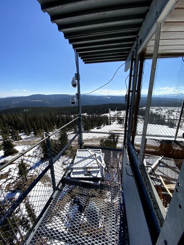
Introduction
In 2020, the Center of Excellence for Advanced Technology Aerial Firefighting (CoE) provided
incident support to a pair of Colorado wildland fires using a cache of data link radios and pan-
tilt-zoom (PTZ) cameras. The purpose of this support on the Grizzly Creek and Cameron Peak
Fires was to (1) allow fire managers to remotely monitor areas of fire activity, (2) allow
evacuated civilians and the general public to view fire behavior around threatened
communities, and (3) extend internet connectivity to firefighters operating in remote areas.

The CoE began purchasing data link equipment in 2019, relying on off-the-shelf technologies
commonly used by wireless internet service providers (WISPs) to provide internet access to
rural homes and businesses. The CoE adapted this technology (which is intended for
permanent deployments) for use on temporary deployments in which speed of setup and
teardown is of the essence and infrastructure, such as towers and electrical power, may be
unavailable. In the summer of 2019, the CoE conducted a 70-day deployment of this
equipment to conduct video surveillance of a debris flow in Southern Colorado.

In preparation for deployments in 2020, the CoE upgraded this cache by purchasing PTZ
cameras that can be rotated and zoomed remotely, allowing operators greater flexibility than
the CoE’s previous system that relied on fixed cameras. The CoE also purchased additional
batteries and solar power equipment, allowing three locations to operate using solar energy,
in addition to locations that operate with A/C electrical power.

In 2020, the equipment was deployed on the Grizzly Creek Fire from August 16 to September
21, with four radio sites used and two cameras deployed. On the Grizzly Creek Fire,
approximately 750 gigabytes of video were streamed over the network. The Cameron Peak
Fire deployment began on September 24 and concluded on November 4, with five sites
deployed at various times. The public viewed the Cameron Peak Fire streams 219,981 times
through YouTube Live. In total, the equipment was deployed for 75 days on these two fires.

          Figure 1— Nighttime near infrared view from camera on Grizzly Creek Fire
Center of Excellence for Advanced Technology Aerial Firefighting                         Page 2
cofiretech.org                                                                        1.13.2021
Technology Used
Equipment was purchased to support the project in 2019 and 2020. All equipment was
available commercially and the only custom integration the CoE performed was the wiring of
the solar panels and batteries with in-line fuses and connectors.
Table 1— Data Link and Camera Equipment Deployed by the CoE in 2020

Equipment Name                             Purpose of Equipment

Data Link Equipment

Ubiquiti PowerBeam® AC Gen 2               Radio used for short- to long-range point-to-point links

Ubiquiti Rocket® Prism AC with airMax®     Radio that integrates with a variety of antennae; used in 2020 for
120° sector antenna and RocketDish™        long-range point-to-point links and point to multi-point links

Ubiquiti NanoBeam® AC                      Small form-factor radio used for short-range point-to-point links

Ubiquiti UniFi® AC mesh access point       WiFi access point used to provide internet to firefighters

Ubiquiti UNMS System                       Remote monitoring system for Ubiquiti products

Sierra Wireless RV50 Modem                 Low-power cellular modem for connecting radios and cameras to
                                           Verizon or AT&T cellular internet

Power Equipment

Ubiquiti sunMax™ SolarPoint                Solar controller for charging batteries and ethernet switch with
                                           power over ethernet for powering cameras and radios

2x 55 Amp Hour Sealed Lead Acid Battery    Energy storage for solar-powered nodes, provides 24 volt output
wired in series

2x 180 watt Solar Panels wired in series   Energy collection for solar-powered nodes

Camera Equipment

Axis M5525-E PTZ camera                    Camera with 10x optical zoom

Axis P5655-E PTZ camera                    Camera with 32x optical zoom

TyCon TP-POE-2456D                         Power over ethernet converter; converts power from the format
                                           created by the SolarPoint to a format usable by the Axis cameras

Intel NUC with Milestone video manage-     Computer with video server software; allows video to be recorded
ment system software                       and for users to login to a website or mobile app to steer cameras.

CamStreamer                                Software running on the Axis Camera to stream the feed directly to
                                           YouTube Live or other destinations

Google Chrome Remote Desktop               Remote access software for accessing the local network housing the
                                           cameras and radios; allows for camera control and administration

Page 3                              Center of Excellence for Advanced Technology Aerial Firefighting
cofiretech.org                                                                            1.13.2021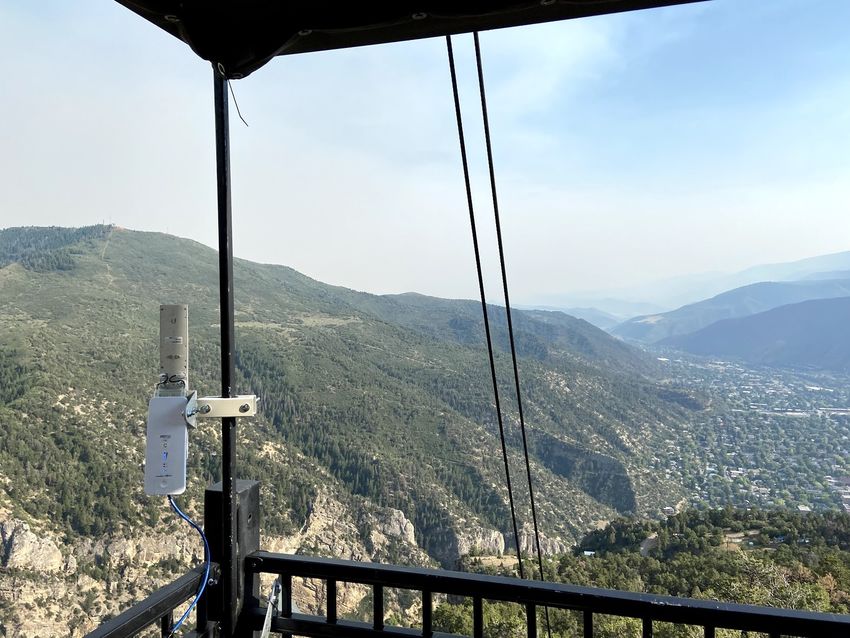
Grizzly Creek Fire
CoE staff deployed on the Grizzly Creek Fire in August 2020 to conduct a resource tracking
pilot project deployment using the Team Awareness Kit (TAK) mobile app. As part of this pilot
                                        project, CoE staff anticipated a need to extend
                                        internet connections to remote fire camps for the
                                        purpose of allowing firefighters to access updated fire
                                        maps using TAK. Staff packaged the data link cache
                                        into a truck and readied it for immediate use should
                                        the opportunity arise. Ultimately, all firefighters
                                        participating in the resource tracking pilot project had
                                        access to mostly reliable cellular internet, allowing
                                        them to use the TAK app. However, CoE staff notified
                                        the incident management team (IMT) on the fire
                                        about the data link and camera equipment cache and
                                        offered to deploy it in a video surveillance role if
                                        needed.

                                           The team requested that a camera with control access
                                           be set up to monitor fire activity in the No Name
                                           Creek drainage northeast of the city of Glenwood
Figure 2— PowerBeam installed at home of   Springs, Colorado. In this area, forward progression of
CoE staff member in Glenwood Springs      the fire had been stopped in the bottom of the
drainage, but the fire still posed a threat should it cross the drainage. No Name Creek drains
into the Colorado River in Glenwood Canyon and Lookout Mountain on the opposite side of
Glenwood Canyon offers an excellent view up the No Name drainage.

A CoE staff member lives in Glenwood
Springs and offered to host the internet
connection and video server for the link
using a PowerBeam. Lookout Mountain
has a direct line-of-sight to much of
Glenwood Springs, but unfortunately this
staff member’s house is hidden from the
mountaintop by a spur ridge. As a result,
CoE staff calculated that a repeater site
would be needed to bounce the signal to
Lookout Mountain. Fortunately, the
Glenwood Caverns Adventure Park on         Figure 3— Repeater radio at Glenwood Adventure Park
top of Iron Mountain has line-of-sight to
both the house in Glenwood Springs and the top of Lookout Mountain. Park staff agreed to
allow the CoE to place a repeater radio on a ride at the park, so CoE staff installed a Rocket®
Prism AC with airMax® 120° sector antenna and tied it into the park’s electrical power. This

Center of Excellence for Advanced Technology Aerial Firefighting                          Page 4
cofiretech.org                                                                         1.13.2021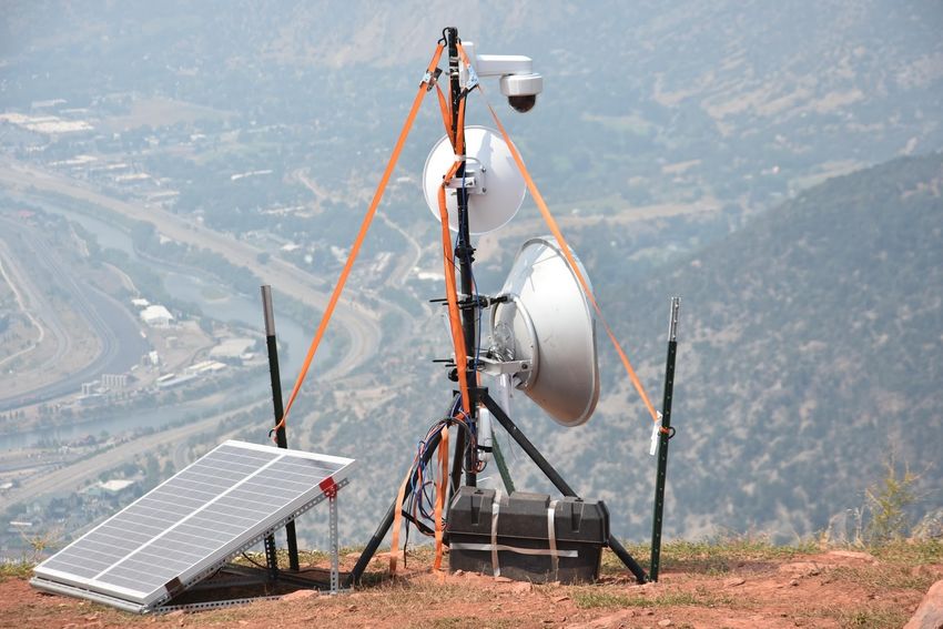
radio communicated with both the house in town and the node at the top of Lookout
Mountain.
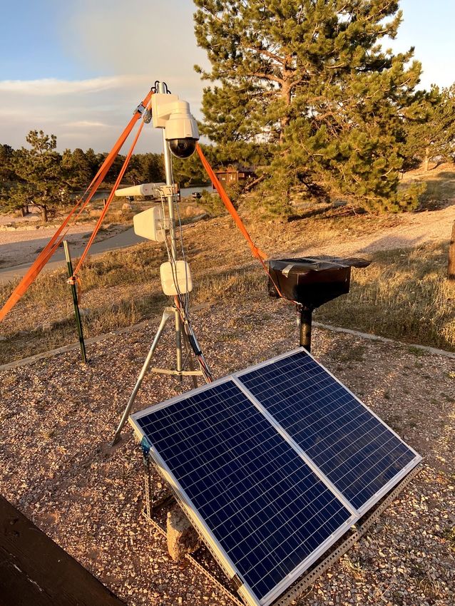
On Lookout Mountain staff set up a tripod to host a PowerBeam and an Axis P5655-E camera.
The system was powered by solar power. Midway through the deployment, a thunderstorm
caused the solar panel and its attached aluminum tripod frame to blow away from the tripod.
Fortunately, no damage occurred
and CoE staff plugged the panels
back in and weighed them down
with rocks.
In Glenwood Springs, a
commercial internet connection
was procured for use by the
network at the CoE staff
member’s house. CoE staff stood
up the Milestone server on this
internet connection and
connected it to the camera. Two
Milestone logins were created,
Figure 4— Equipment installed at Lookout Mountain one with PTZ access to the
camera and one with only the
ability to view the feed. These logins, and details on how to access the feeds through the
server’s web interface or through the Milestone mobile app, were provided to the IMT.
Once the video feed at Lookout Mountain was operational, the CoE received positive feedback
on it from the team, as well as a request to set up a second feed at Windy Point to provide a
closer look at the No Name Creek drainage. Staff used the Ubiquiti airLink tool, which allows
for the planning of radio links to ensure that they will function as intended, and determined
that a link from Windy Point to Lookout Mountain should be just barely possible. When onsite
at Windy Point, staff could see the radio towers at Lookout Mountain from one rock outcrop
when looking between the treetops. This location was selected and a solar powered camera,
PowerBeam, and a WiFi access point were transported to the site by Utility Terrain Vehicle
(UTV) and set up. A Rocket Prism AC radio with RocketDish was set up at the Lookout
Mountain portion of the link to provide the most robust signal possible.
Figure 5— Internet traffic passed by Ubiquiti radios over an hour (note spikes in usage as firefighters used WiFi)
Page 5 Center of Excellence for Advanced Technology Aerial Firefighting
cofiretech.org 1.13.2021
Figure 6— Schematic of equipment and radio links used during the Grizzly Creek Fire

The link to Windy Point from Lookout Mountain was successfully established and an Axis
M5525-E camera was set up to monitor the fire. Since Windy Point has marginal cell service,
yet was staffed by a fireline lookout and was a meeting point for supervisors, CoE staff also
stood up a WiFi hotspot at this site. The hotspot had no password and utilized the same radio
links as the camera for accessing the internet connection in Glenwood Springs. The Ubiquiti
radio links were optimized for range rather than performance, so the connection speed at
Windy Point was limited to roughly 15
megabits per second down and 4
megabits per second up, but was
sufficient for video chats, phone calls,
and web browsing.

In total, the system on the Grizzly
Creek Fire was in operation for 34 days.
During this time, the two video
cameras were in constant operation,
feeding an estimated 750 gigabytes of
data to the Milestone server. Video
control access was provided to IMT       Figure 7— Windy Point camera feed operational during an
                                         early September snowstorm
members ranging from the Division
Supervisor covering the No Name Creek drainage, to the Branch Director and Planning
Operations. The CoE also set up a monitor displaying the live video feeds at the Incident
Command Post operations yurt. Once fire activity had diminished in the No Name Creek
drainage, the IMT allowed the equipment to be removed and CoE staff spent a day tearing
down the radios at Windy Point, Lookout Mountain, and Iron Mountain.
Center of Excellence for Advanced Technology Aerial Firefighting                            Page 6
cofiretech.org                                                                           1.13.2021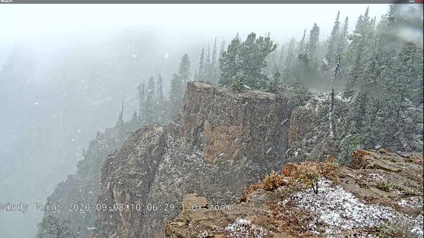
Cameron Peak Fire
Days after the Grizzly Creek Fire deployment ended, the Cameron Peak Fire in Northern
Colorado experienced rapid growth, leading to the evacuation of Red Feather Lakes and
surrounding communities. The CoE was contacted by a Colorado Division of Fire Prevention
and Control (DFPC) Battalion Chief (who was acting as an Agency Administrator on the IMT for
the fire) with a request to set up a video camera near Red Feather Lakes. In addition to
providing video to the IMT, this camera was intended to serve a video feed to the general
public, allowing evacuated citizens and others to view fire behavior. The intent of this
deployment was to (1) help inform the public about the fire, and (2) supplement the outreach
efforts of the IMT’s public information office.

A forecasted wind event that would push the fire
further to the east necessitated a tight time-frame
to set up the camera. The Battalion Chief identified
an area to set up the camera where it could be
expected to remain intact should the fire burn
through the area and where cellular internet was
present. The CoE responded to the fire with a
single camera and solar power system and received
assistance from the DFPC Montrose Helitack crew
to set up the system. To expedite the deployment,
rather than establishing a link to a traditional
internet connection using the Ubiquiti radios, the
CoE deployed a cellular modem at the camera itself
to directly serve the video stream onto the
internet.

The camera was set up on September 24 and a
YouTube live stream was initiated from the camera.
The CoE used an app called CamStreamer that ran
on the camera itself to interface with YouTube and
pass the stream. Unlike during the Grizzly Creek
                                                      Figure 8— Camera and cellular data link in
Fire deployment, the CoE had no capability to         operation at Red Feather Lakes
remote into the camera to control it during this
deployment, so a CoE staff member set up the camera to conduct an automated tour in which
it panned and zoomed across its field of view to cover the present location of the fire and
areas of expected fire growth.

The system used Verizon cellular internet and streamed video to YouTube at 720-pixel (p)
resolution. On the first night of the deployment, power was cut to Red Feather Lakes and, as a
result, other video sources—such as a county-operated webcam that served still images from
a nearby site—failed. However, the system continued running off solar power and provided
the only public video stream of the fire during that time. After a week in operation, the system

Page 7                        Center of Excellence for Advanced Technology Aerial Firefighting
cofiretech.org                                                                      1.13.2021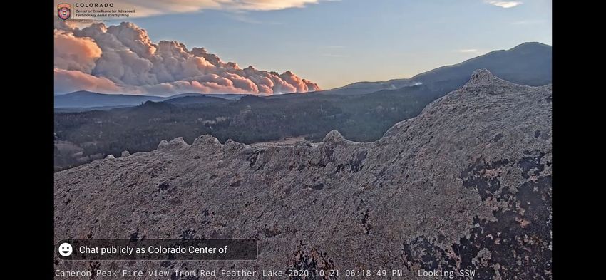
experienced a short period of
                                                                downtime, and while the
                                                                stream automatically
                                                                recovered, the CoE was
                                                                concerned about continuing to
                                                                rely on cellular internet since it
                                                                had become apparent that the
                                                                Cameron Peak Fire would be a
                                                                long-duration event and would
                                                                require weeks of additional
                                                                monitoring.

                                                                 As a result, the CoE returned to
                                                                 the fire on October 2 and, with
Figure 9— Snapshot from YouTube Live stream of the Cameron Peak
Fire viewed from Red Feather Lakes                               assistance from Montrose
                                                                Helitack, repositioned the
camera approximately 1 mile to the west at a location where it could link to the Red Feather
Lakes Volunteer Fire Department using NanoBeam radios. This allowed the CoE to use a DSL
line at the fire station as the internet connection for
the stream. Stream resolution was increased to
1080p and a second stream was initiated at the
Deadman Fire Lookout Tower, approximately 8 miles
west of Red Feather Lakes. The CoE stood up a solar
powered camera on the observation deck of this
tower and linked it to the fire station using
PowerBeam radios. This second stream was served
to YouTube at a resolution of 720p. The CoE also
installed a Windows computer running Google
Chrome Remote Desktop at the fire station; this
allowed CoE staff to remotely access the computer
and login to the configuration pages for the cameras.
In addition, the system allowed staff to update the
video tours to account for changes in fire growth and
to remotely administer the radio and solar
equipment.

This system operated for approximately a week, until
a winter storm hit the fire area and iced over the
solar panels. The site at Red Feather Lakes came
                                                     Figure 10— Storm damaged solar panels at the
back up after the storm cleared, but aside from a    Deadman Lookout site
brief moment of uptime, the site at Deadman
Lookout did not function after the storm. When the CoE took down the equipment in
November, staff found that the solar panels—which had been zip-tied to the lookout tower

Center of Excellence for Advanced Technology Aerial Firefighting                          Page 8
cofiretech.org                                                                         1.13.2021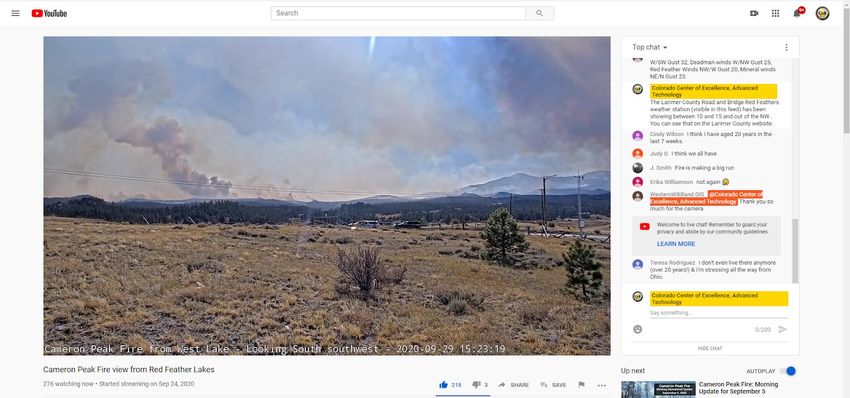
decking—had been ripped loose and
                                                      flipped over so they were facing the
                                                      ground. This removed the source of power
                                                      for the node and took down the Deadman
                                                      site.

                                                       By mid-October, fire activity near Red
                                                       Feather Lakes had abated and evacuation
                                                       orders in this area were lifted. However,
                                                       the Cameron Peak Fire continued to burn
Figure 11— Helicopter water drop filmed from camera on to the east and threatened communities
Horsetooth Mountain                                    west of Fort Collins, leading to new
 evacuation orders. On October 16, CoE staff again visited
 the fire and set up a camera on Horsetooth Mountain to
 monitor fire behavior in the area of Redstone Canyon and
 Buckhorn Mountain. Staff received assistance from DFPC
 Cañon City Helitack to set up the camera and coordinated
 with Larimer County radio and IT staff to utilize a county
 radio tower and infrastructure. The camera was connected
 directly to county internet at Horsetooth Mountain and
 received power from backup generators that were
 providing power to the site. County IT staff assisted the
 CoE in remotely accessing the camera, allowing a tour of
 the fire to be programmed and updated.

On October 22, the camera at Red Feather Lakes captured
distant footage of the East Troublesome Fire as it
experienced extreme fire behavior and made a run through
Grand Lake into Rocky Mountain National Park. Shortly
after this, the Red Feather Lakes camera went offline. This
                                                                Figure 12— Larimer County radio
was likely due to the positioning of solar panels at this site, technician installing camera at
                                                       which— Horsetooth Mountain
                                                       as the
                                                       sun became lower in the sky each day—
                                                       were increasingly blocked by boulders
                                                       from receiving light sufficient to recharge
                                                       the batteries.

                                                       Additional snowfall in late October finally
                                                       facilitated containment of the Cameron
                                                       Peak Fire, so on November 3-4 CoE staff
                                                       worked with Cañon City Helitack
                                                       personnel and Larimer County radio staff
Figure 13— East Troublesome Fire smoke column captured to disassemble all remaining equipment
from Red Feather Lakes
Page 9                         Center of Excellence for Advanced Technology Aerial Firefighting
cofiretech.org                                                                       1.13.2021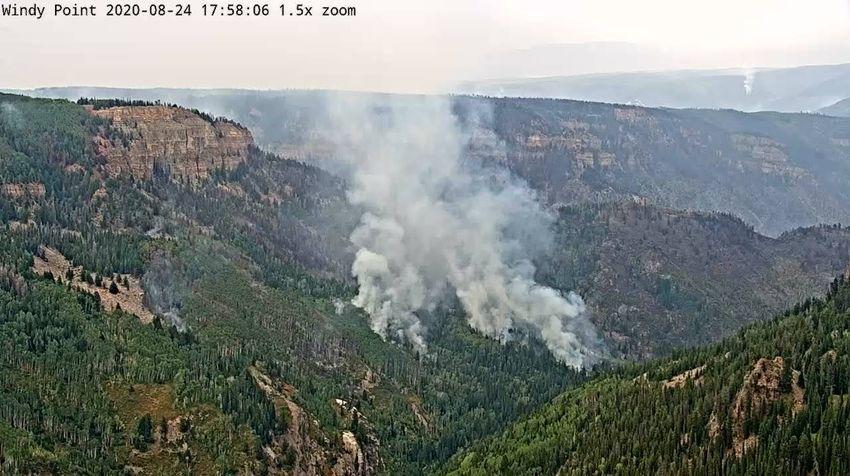
on the fire. All equipment was successfully recovered and the only damage during the
deployment was to the aluminum frames on solar panels at the Deadman site, which had been
twisted when the panels were ripped loose during the winter storm. In total, three cameras
were deployed on the Cameron Peak Fire for 40 days. Throughout this time period, the public
viewed the Cameron Peak Fire streams 219,981 times via YouTube Live.

         Figure 14— Schematic of equipment and Ubiquiti radio links used during the Cameron
         Peak Fire (cameras operating off cellular or County internet not shown)

Next Steps
Over the winter of 2020–2021, CoE staff will rehabilitate equipment used during the fire
season and will prepare for future deployments of this technology to assist in public safety
responses in Colorado. Staff will explore enhancements for camera control, which will allow
incident managers to reliably control cameras and also record video for later analysis.
Additionally, further exploration of streaming to public sites such as YouTube Live will occur,
with emphasis on optimizing stream quality and adding overlays to help viewers understand
where the cameras are looking in real time. The CoE expects to formalize an ordering
procedure for this equipment and conduct additional outreach to help DFPC managers and
other first responders access this cache to extend internet connections or stream video during
future disaster responses.

Center of Excellence for Advanced Technology Aerial Firefighting                                Page 10
cofiretech.org                                                                                1.13.2021
You can also read