PARK ACCESS PLAN 2020 - JULY 2020
←
→
Page content transcription
If your browser does not render page correctly, please read the page content below
2020
PARK ACCESS PLAN
H U R O N - C L I N T O N M E T R O PA R K S

JULY 2020
Created for:
Huron-Clinton Metroparks

       Created by:
     OHM Advisors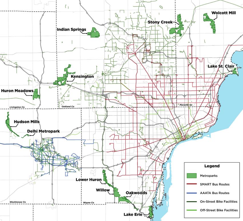
Table of Contents

01   INTRODUCTION

     About ............................................................................................................................. 4
     Project Goals ................................................................................................................... 4

02 EXISTING CONDITIONS

     About................................................................................................................................ 6
     Catchment Area Analysis .................................................................................................. 6
     Demographic Analysis ...................................................................................................... 6
     Gap Analysis..................................................................................................................... 10

03 PARK ACCESS RECOMMENDATIONS

     Park Prioritization............................................................................................................. 12
     Individual Park Recommendations...................................................................................... 14
     Funding........................................................................................................................... 20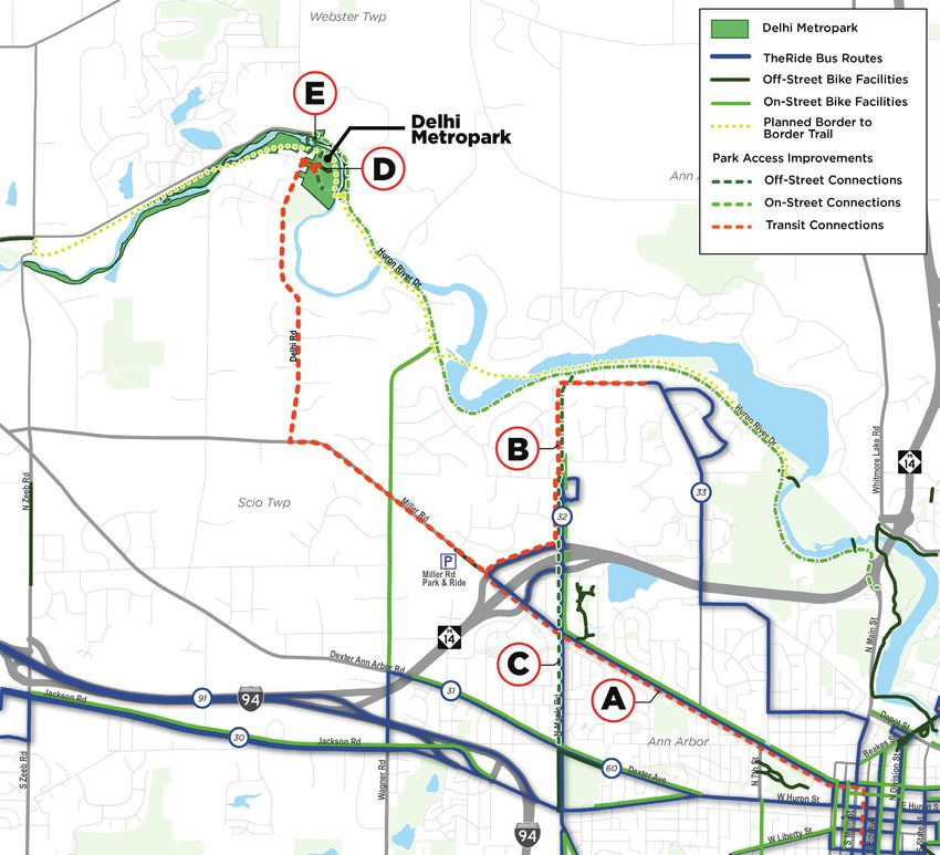
01
   Chapter/Section Title

   INTRODUCTION

   ABOUT                                                      Huron Clinton Metroparks Authority can better
                                                              connect their parks to public transportation and non-
   The Huron Clinton Metroparks Authority (HCMA)              motorized transportation systems to increase access for
   is a regional parks system created by the citizens of      all residents of the region. Connecting the parks to these
   Southeast Michigan in 1940 to provide recreational         networks will also allow for more park users to access
   and educational opportunities to all residents. The        their preferred park without a private vehicle, reducing
   Metroparks are located in a greenbelt surrounding the      greenhouse gasses in the parks, slowing the degradation
   Metro Detroit area and allow for access to open space,     of vehicle infrastructure in the park, and contributing to
   natural environments, and various outdoor activities       improved safety.
   throughout the entire year. The Metroparks are located
   in five counties throughout Southeast Michigan –
   Macomb, Wayne, Oakland, Washtenaw, and Livingston
   – and are intended to provide a natural retreat from       PROJECT GOALS
   urban and suburban life.
                                                              At the onset of the project, a kick-off meeting was held
   As the Southeast Michigan region has grown over the
                                                              with HCMA staff to better understand the previous
   past 80 years, so has the parks’ popularity. However,
                                                              work around improving access to the Metroparks. The
   the parks are almost exclusively used by residents with
                                                              following goals of HCMA will be furthered through this
   access to private automobiles and those lacking access
                                                              project:
   to transportation are unable to access the Metroparks.
   As the popularity of the parks has risen, more and          • Connect urban areas across the Metro Region to the
   more vehicles are utilizing the park contributing to the      Metroparks
   degradation of these pristine natural environments.
   Additionally, the 2020 COVID-19 pandemic has led            • Further HCMA equity goals through the fair
   to an increased demand for quality parks as residents         distribution of resources and improvements across the
   look for ways to recreate while social distancing. The        Metro Region
   Metroparks are a great resource for Southeast Michigan,     • Decrease potential barriers of entry through increased
   but not all residents have equal access to the parks          opportunities for transit use and non-motorized
   because they may not have access to a vehicle and the         connections
   Metroparks are not connected to public transit.
   The HCMA Park Access Plan will explore ways the

4 Huron-Clinton Metroparks
Introduction

Figure 1-1: HCMA Parks and Existing Mobility Infrastructure

                                                              Park Access Plan 5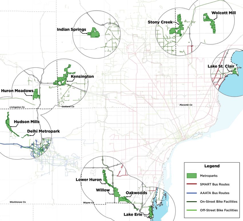
02
   Chapter/Section Title

   EXISTING CONDITIONS

  ABOUT                                                       vehicle count data and U.S. Census data have been
                                                              incorporated as well.
   In order to best understand which parks have the
   most opportunity to improve access, an analysis of the
   existing demographic and transportation conditions was
   undertaken. HCMA’s 2019 Scanning Report was used           DEMOGRAPHIC ANALYSIS
   as the basis to determine where park visitors are coming
   from and to which parks they go.                           A demographic analysis of each of the zip codes
                                                              identified as part of a Catchment Area was performed
                                                              to determine which parks have the greatest number of
                                                              potentially transit dependent visitors. In many cases,
   CATCHMENT AREA ANALYSIS                                    areas that have higher levels of public transit ridership
                                                              also have high population densities for the following
  The park Catchment Areas are the general areas where        demographic conditions:
  most park visitors are coming from. The 2019 HCMA
  Scanning Report summarized and analyzed the park            • Overall population density
  visitor passes that were scanned upon entering the park.    • Zero car household density
  This analysis allowed HCMA to determine where park
  users are coming from. As expected, visitors who live in    • Senior population density
  the zip codes surrounding a given Metropark tend to         • Low income individual population density
  visit that park most. This data was used to determine       • Child population density
  the Catchment Area for each park in order to perform
  a demographic analysis. The demographic analysis will
  identify those zip codes that contain population groups     These data were compiled from the US Census website
  that may be more reliant on public or non-motorized         and analyzed at the block group level (for the entire
  transportation and will help the project team identify      region) and the zip code level (for the Metropark
  recommendations to improve access to the nearby parks.      catchment areas). The demographic data was used to
                                                              find the ‘Transit Score’ for each of the geographic levels
  This report was compiled using data downloaded              identified.
  from the Metroparks server recorded through
  barcode scanning of vehicle passes upon entry into          ‘Transit Score’ is a measure of transit dependency or
  the Metroparks. In some instances, revenue data,             propensity that can be used to estimate how likely

6 Huron-Clinton Metroparks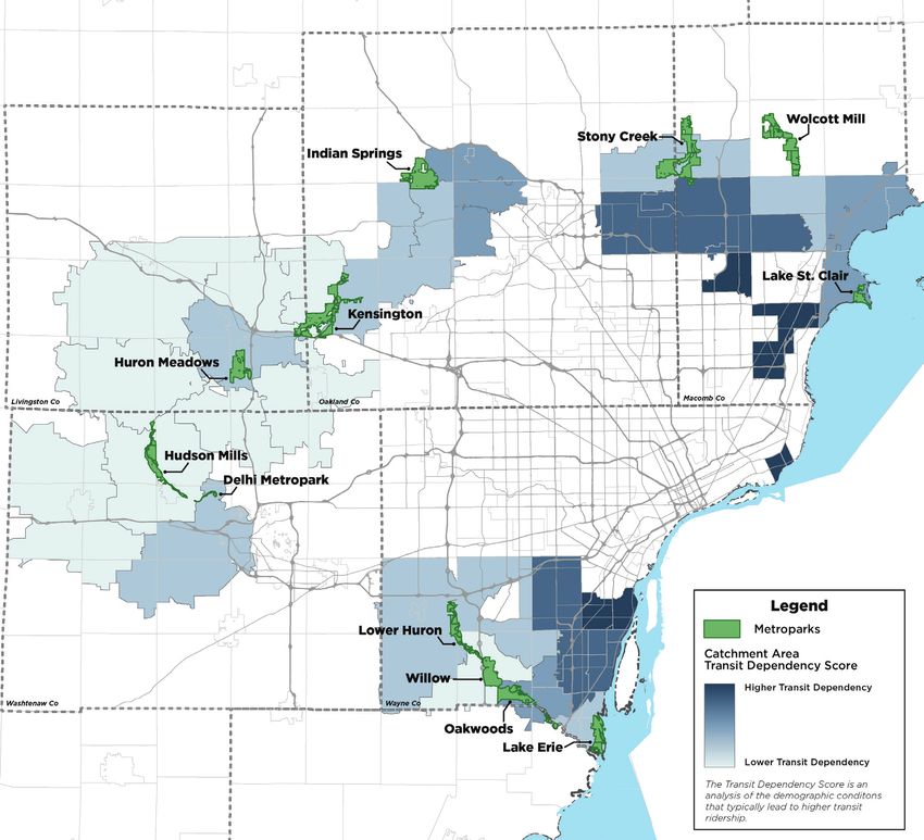
Existing Conditions

the people in a given area are to use public transit.      this plan a ‘Transit Score’ analysis was completed for the
To calculate an area’s ‘Transit Score’, each set of        five counties in the HCMA region, as well as for each of
demographic density data is sorted largest to smallest     the zip codes in the Catchment Areas (Figure 1-2). An
and divided into 5 equal groups based on the value. The    overall Metropark Transit Score was also developed by
geographic areas in the highest cohort are awarded a       analyzing the demographic conditions in each catchment
score of 5, the next cohort is awarded a score of 4, and   area as well.
so on. This process is repeated with each demographic      The Transit Score analysis for the full metro area shows
dataset. An overall ‘Transit Score’ is calculated by       that the areas closest to the City center, Detroit and
summing the score of each dataset. For the purposes of
Figure 1-2: Catchment Area Map

                                                                                                     Park Access Plan 7
the surrounding suburbs, have the highest potential         the parks that touch large areas of transit dependency.
  dependency on transit. This also matches up with            The long-haul routes such as Gratiot, Michigan, and
  where the majority of the transit service is located.       Woodward Avenue SMART Bus routes provide
  This is important because these residents desire access     potential connections for the Oakland, Macomb, and
  to open spaces but may not have a chance to access          Wayne County Metroparks. The Washtenaw County
  many of the Metroparks. This analysis is helpful in         Metroparks are near to The Ride’s system and could be
  determining if there are potential transit connections to   connected as well.

   Figure 1-3: Transit Score Map

8 Huron Clinton Metroparks
Existing Conditions

Table 1-1: Demographic Analysis and Transit Scores of Catchment Areas

                                             Zero Car             Senior            Individuals           Child
                   Population
                                            Households          Population           in Poverty         Population

                                                                                                                             Total
                                  Transit             Transit             Transit             Transit             Transit
 Metropark     Total    Density             Density             Density             Density             Density             Transit
                                  Score               Score               Score               Score               Score
                                                                                                                            Score

 Lake St.
 Clair        107,228   2,516       5        92.4       5       377.9       5       367.9       5       420.09      5         25

 Stony
 Creek        366,427   3,356       5        53.9       5       537.9       5       188.2       4       616.81      5         24

 Lake Erie
              208,601   2,195       5        56.1       5       370.7       5       264.2       5       384.59      4         24

 Wolcott
 Mills        147,173   1,968       4        21.4       4       249.8       4        99.9       3       398.04      4        19

 Indian
 Springs      101,750   1,717       4        21.9       4       264.8       4       132.3       4       289.97      3        19

 Oakwoods
              91,917    1,282       4        28.1       4       188.3       3       188.0       4       251.23      3        18

 Dexter-
 Huron        65,562    1,040       3        14.8       2       170.0       3        68.9       2       190.23      3        13

 Willow
              93,815     724        2        17.4       3        94.7       2        96.7       3       142.76      2        12

 Delhi
              43,770     981        3        14.3       2       174.3       3        47.9       2       165.45      2        12

 Kensington
              172,781    602        2        7.5        1        96.3       2        28.0       1       111.44      2         8

 Lower
 Huron        80,574     572        2        14.7       2        75.7       1        75.6       2       108.92      1         8

 Huron
 Meadows      76,169     514        1        5.8        1        86.4       2        27.5       1       85.26       1         6

 Hudson
                                                                            1         24.0
 Mills        132,623    409        1        7.7        1        70.3                           1       69.66       1         5

                                                                                                              Park Access Plan 9
GAP ANALYSIS                                                        determining the overall connection opportunity:

                                                                        • Total number of transit routes within buffer
    In order to determine which of the Metroparks
    present the best opportunity to connect to existing                 • Driving distance to nearest transit stop
    transportation infrastructure, a high-level gap analysis            • Total non-motorized facility length outside of park,
    was performed. The gap analysis consisted of drawing                  within buffer
    a 6-mile buffer from the main meeting place1 in each                • Total non-motorized facility length inside of park
    park and identifying the public transportation and
    non-motorized transportation facilities that exist in the
    buffer zone. The 6-mile buffer was chosen because this              Transportation options nearby the Metroparks vary
    adequately captured the potential public transit routes             depending on where the park is located. Some parks are
    near to the parks while representing the farthest someone           surrounded by non-motorized transportation facilities
    would likely bike to access the park.                               but very few public transit routes, some have many
                                                                        potential connections to transit and fewer bike and
    The gap analysis considered four data points to                     pedestrian connections, and some are more isolated and
                                                                        only accessible with a vehicle.
    Table 1-2: Gap Analysis

                                            Non-Motorized                                            Public Transit

                         Total Length Outside          Total Length Inside        Distance to Nearest Total Routes in
     Metropark
                         of Park                       Park                       Stop                Buffer
     Lake St. Clair                 13.46                        2.81                     3.4 miles                   7

     Stony Creek                    95.45                        8.08                     7.1 miles                   1

     Lake Erie                      20.73                        4.11                     6.5 miles                   1

     Wolcott Mills                  28.65                          0                           n/a                    0

     Indian Springs                 40.61                        5.07                          n/a                    0

     Oakwoods                       19.48                        4.28                          n/a                    0

     Dexter-Huron                   17.84                        1.76                     5.2 miles                   7

     Willow                         15.97                        6.33                     8.4 miles                   1

     Delhi                          41.56                        0.09                     3.1 miles                   26

     Kensington                     29.63                        20.3                          n/a                    0

     Lower Huron                    16.19                        6.82                     8.2 miles                   3
     Huron
                                    15.37                          0                           n/a                    0
     Meadows
     Hudson Mills                    5.8                          8.3                          n/a                    0

    1This   could be the park office, large parking area, or main activity area of the park.

10 Huron Clinton Metroparks
Existing Conditions
Lake St. Clair, Delhi, and Dexter-Huron are the parks Springs, and Kensington would be best suited to more
that present the most opportunity to connect to nearby bicycle and pedestrian connections as there are many
transit facilities since they are relatively close to existing existing connections to the surrounding communities
SMART and AAATA service. Stony Creek, Indian into these parks.
Figure 1-4: Gap Analysis Map
Park Access Plan 1103
Chapter/Section Title
PARK ACCESS RECOMMENDATIONS
PRIORITIZATION existing transit, the potential is greater to connect other
residents who may not have access to a vehicle but would
To determine which of the Metroparks present the best like to visit the Metroparks.
opportunity for potential new transit and non-motorized One of HCMA’s goals for improving park access is
connections, the existing conditions and gap analysis to explore solutions that are equitable. To meet this
data was compiled and summarized for each park. Since goal, Stony Creek will not be carried forward to the
transportation resources are limited, the prioritization recommendations phase. Stony Creek was chosen
process helps determine which of the Metroparks because it is the furthest from the existing transit
would benefit most from these connections and which routes and is already connected to the existing non-
would be the most efficient to connect from a resource motorized network. Delhi, Lake St. Clair, and Lake Erie
standpoint. An objective decision was made by utilizing Metroparks have a higher need for access improvements
the data analysis. and represent the three regions of the Metroparks
Table 1-3 shows the results of a high-level prioritization Authority, meaning any future investments will touch a
exercise that evaluates each Metropark on the ease larger portion of the region.
of connecting to non-motorized and public transit
infrastructure. The parks that had the highest total
distance of non-motorized infrastructure both inside
and outside of the park, the most transit routes, were
the closest to existing transit stops, and had the highest
overall transit score were scored the highest. These parks
all are located closer to the urbanized areas and see a
higher number of visitors each year.
Delhi, Stony Creek, Lake St. Clair, and Lake Erie
Metroparks were the top scoring parks and received
the highest priority. These parks have a higher amount
of non-motorized facilities nearby the park, as well
as within the park. They are also within reasonable
connecting distance to existing transit routes and have a
relatively higher amount of transit dependent residents.
Additionally, because these parks are relatively close to
12 Huron-Clinton MetroparksPark Access Recommendations
Table 1-3: Prioritization Matrix
Non- Non-
Transit Distance to Transit motorized motorized
Metropark Total Score
Score Nearest Stop Routes Length Length
Outside Inside
Delhi 14
Stony Creek 13
Lake St. Clair 12
Lake Erie 11
Dexter-Huron 11
Indian Springs 10
Lower Huron 10
Willow 9
Wolcott Mills 8
Oakwoods 8
Kensington 7
Huron
4
Meadows
Hudson Mills 4
Park Access Plan 13Lake St. Clair Metropark
RECOMMENDATIONS
HARRISON TOWNSHIP
CLINTON TOWNSHIP
MACOMB COUNTY
MT. CLEMENS
SEMCOG
SMART
TIMEFRAME POTENTIAL PARTNERS
Action A: Add a HAWK signal and other crossing
SHORT l l
improvements at N. Pointe Pkwy and 16 Mile
Action B: Add a bike lane along N. Pointe Pkwy connecting
LONG l l
to S. River Road
Action C: Improve visibility of existing crossing at 16 Mile
SHORT l l
Road and Jefferson Avenue
Action D: Harper shared use path from 16 Mile to Wellington
LONG l l
Crescent
Action E: Provide a shuttle that runs between the park and
Gratiot that picks users up from bus stops (peak season SHORT l l l l l
only)
Action F: Transit route on Gratiot or Jefferson connecting to
LONG l
neighborhoods
Short term time frame is 0 to 3 years, long term timeframe is over 3 years.
Global Recommendations:
• Build strategic connections from apartment buildings/complexes along 16 Mile Road to Freedom Trail
(especially near Harper Avenue and 16 Mile Road)
• Develop opportunities for strategic crossing of 16 Mile Road to connect neighborhoods
14 Huron Clinton MetroparksPark Access Recommendations
Figure 1-5: Lake St. Clair Metropark Recommendations
The recommended access connections for Lake St. Clair along Metro Parkway and serving the park could help
Metropark attempt to foster connections between transport passengers from SMART’s Gratiot, Harper, 15
the existing non-motorized network, the adjacent Mile, and Jefferson Routes. Alternatively, a dedicated
neighborhoods, and nearby transit routes. Adding route deviating from Gratiot serving the park could
safer and more visible crossing infrastructure for non- connect many transit dependent neighborhoods in
motorized users to cross 16 Mile Road/Metro Parkway the region. An extension of SMART Route 635 could
at N. Pointe Parkway, Jefferson Road, and S. River Road also offer limited stop service into the park from many
will help foster connections to the Freedom Trail, which transit dependent neighborhoods. All potential transit
has direct access to the park. options would operate during the peak season on the
Transit access to Lake St. Clair Metropark could be busiest days to maximize ridership and make the most of
achieved in a number of ways. A shuttle running limited funds.
Park Access Plan 15Delhi Metropark
RECOMMENDATIONS
ANN ARBOR TOWNSHIP
WASHTENAW COUNTY
CITY OF ANN ARBOR
SCIO TOWNSHIP
THE RIDE
SEMCOG
TIMEFRAME POTENTIAL PARTNERS
Action A: Run an express shuttle to Delhi Metropark from
the Ann Arbor Area Transportation Authority - Blake Transit
LONG l
Center (4-5 stops total and only during the summer during
peak times)
Action B: Run a circulator shuttle hitting The Ride Routes 32
SHORT l
and 33
Action C: Connect Maple Road path to the Border-to-Border
LONG l l l l
Trail
Action D: Build sidewalk/path connection along park
SHORT HCMA Lead
entrance road
Action E: Add a bike lane along Huron River Drive to Delhi
SHORT l l
Road/Delhi Metropark
Short term time frame is 0 to 3 years, long term timeframe is over 3 years.
16 Huron Clinton MetroparksPark Access Recommendations
Figure 1-6: Delhi Metropark Recommendations
The recommended access connections for Delhi Delhi Metropark is near most of the transit routes
Metropark are intended to connect to the non-motorized operated by TheRide (Ann Arbor Area Transportation
and transit network facilities in nearby Ann Arbor. Ann Authority) and could be connected in a few ways. One
Arbor has a number of transit dependent neighborhoods option is to operate a limited stop route starting at the
that could connect to the park. A trail/shared use Blake Transit Center and traveling along Miller Road
path connection from central Ann Arbor along Maple and Delhi Road and linking with Route 32. Another
Road to Huron River Drive, and eventually the Border option is to operate a circulator shuttle connecting
to Border Trail, would help foster non-motorized Routes 32 and 33 to the park. Both options would
connections to the Park. Additional pathways from link with the Park and Ride lot on Miller Road. Any
Huron River Drive to Delhi Metropark, and along the potential transit service connecting to Delhi Metropark
entrance road into the park, will help users access the could be operated during the peak season on the most
park from major routes. popular days in order to maximize ridership and reduce
overall operating expenses.
Park Access Plan 17Lake Erie Metropark
RECOMMENDATIONS
CITY OF WOODHAVEN
CITY OF ROCKWOOD
BROWNSTOWN TWP.
CITY OF FLAT ROCK
CITY OF GIBRALTAR
CITY OF TRENTON
SEMCOG
SMART
TIMEFRAME POTENTIAL PARTNERS
Action A: Continue the Jefferson Avenue path
LONG l l l l
connection to park*
Action B: Extend SMART route 160, allowing for access
LONG l
to park
Action C: Create a connection of the interior path
SHORT l
connection on Culpepper Road
Action D: Continue Woodruff Road path connection
LONG l l l
into the City of Flat Rock/Oakwoods Metropark*
Action E: Continue the Gibraltar Road trail to Jefferson
SHORT l
Avenue*
Short term time frame is 0 to 3 years, long term timeframe is over 3 years.
*Additional Coordination:
• Work with Friends of the Detroit River and Downriver Linked Greenways to coordinate trail
connections
18 Huron Clinton MetroparksPark Access Recommendations
Figure 1-7: Lake Erie Metropark Recommendations
The recommended access connections for Lake Erie would connect Oakwoods Metropark to Lake Erie.
Metropark look to take advantage of the existing non- Transit access to Lake Erie Metropark could be achieved
motorized network and connect to future Iron Belle by extending SMART Route 160 to the park along
Trail and Downriver Linked Trail facilities. Adding trail Jefferson Avenue. This would allow riders in transit
connections along Jefferson Avenue and Gibraltar Road dependent neighborhoods in Southern Wayne County
will help connect bicyclists and pedestrians directly into and Detroit to access a Metropark. This service would
the park. A path connection on Culpepper Road would likely be available during the peak season on days when
facilitate non-motorized trips within the park and a park visitation is the highest in order to maximize
pathway connection/extension along Woodruff Road ridership and available operating dollars.
Park Access Plan 19FUNDING OPPORTUNITIES
RTA Funding
The following options should be looked into as potential
The Regional Transit Authority of Southeast Michigan
funding opportunities for the recommendations listed in
(RTA) is a regional entity who’s mission is to manage and
this plan.
secure transportation resources to enhance mobility in
Southeast Michigan. The goal for the RTA is to secure
Ralph C. Wilson additional local funding to expand transit service around
the region. Although no funding has been allocated
The Ralph C. Wilson Foundation funds the Community at this time, a regional transit master plan is being
Foundation of Southeast Michigan in key ways to developed that lays out service goals for SMART, DDOT,
improve the region. Grants in four separate categories and AAATA. With additional funding, connections
honor the lifetime interest of Mr. Wilson and include: to the nearby Metroparks could be made, helping to
the Caregivers Fund, the Design and Access Fund, the connect residents to these vital resources. If funding is
Youth Sports Fund, and the Grosse Pointe Community secured in the future, HCMA should consult with the
Assets Fund. Grants from the Design and Access Fund RTA to identify connection opportunities.
could be used to support walking and biking trails
in Southeast Michigan. Over the past few years, the
Community Foundation for Southeast Michigan has Congestion Mitigation and Air Quality
funded trails, greenways, and bicycle facilities for a (CMAQ)
number of different entities, including HCMA.
CMAQ is a federally funded program administered
through SEMCOG that funds transportation projects
Washtenaw County, Connecting that work towards better air quality and reduction of
Communities Grant congestion. Related projects that are eligible for CMAQ
funding include non-motorized transportation facility
The Connecting Communities grant program is designed improvements such as bike lanes, and shared ride
to assist Washtenaw County communities in developing improvements such as transit.
and enhancing the non-motorized transportation
network. The program is supported by the four-year
Road and Trails Millage (2016) and could help advance Natural Resources Trust Fund (MNRTF)
the walking and biking connections to Delhi and The Michigan Department of Natural Resources’ Natural
the other Metroparks in Washtenaw County. These Resources Trust Fund (MNRTF) primarily allocates
grants would be applied for in partnership with other resources for acquisition and development for outdoor
communities in the county. recreation and natural resource protection. Applications
are evaluated based on natural resource access,
availability of matching funds, financial need, priority
Partnerships with Local Municipalities
projects, and proximity to population clusters. Any unit
Many municipalities around Southeast Michigan have of government with an approved community five-year
dedicated funding mechanisms to add walking and recreation plan is eligible to receive funding through
biking infrastructure outside of dedicated grant funding. MNRTF.
HCMA can work with the communities planning for
these facilities and identify ways for trail connections
to be made, while still serving the greater community.
These connections could be made in the form of on-
street interventions like bike lanes or signed bike routes.
20 Huron Clinton MetroparksPark Access Recommendations
Land and Water Conservation Fund
(LWCF)
The Department of Natural Resources’ Land and Water
Conservation Fund (LWCF) provides matching grants
to local governments for the development of public
recreation areas and facilities. Any unit of government
with an approved community five-year recreation plan is
eligible to receive funding through LWCF.
Outdoor Recreation Legacy Partnership
Program
The purpose of the Outdoor Recreation Legacy
Partnership Program is to provide grants for the
development of outdoor recreation areas and facilities,
primarily in urban areas. Any unit of government, or
combination thereof, that is legally constituted to
provide recreation is eligible to apply for funding.
Park Access Plan 21You can also read