Photographic Reportage on the Rebuilding after the Irpinia-Basilicata 1980 Earthquake (Southern Italy) - MDPI
←
→
Page content transcription
If your browser does not render page correctly, please read the page content below
Communication

Photographic Reportage on the Rebuilding after the
Irpinia-Basilicata 1980 Earthquake (Southern Italy)
Sabina Porfido 1,2, Giuliana Alessio 2, Germana Gaudiosi 2, Rosa Nappi 2,*,
Alessandro Maria Michetti 3 and Efisio Spiga 4

                                          1 Consiglio Nazionale delle Ricerche-ISA, Via Roma 64, 80100 Avellino, Italy; sabina.porfido@cnr.it
                                          2 Istituto Nazionale di Geofisica e Vulcanologia, Sezione di Napoli Osservatorio Vesuviano, Via Diocleziano,
                                            328, 80124 Napoli, Italy; giuliana.alessio@ingv.it (G.A.); germana.gaudiosi@ingv.it (G.G.)
                                          3 Dipartimento di Scienza e Alta Tecnologia, Università degli Studi dell’Insubria, Via Valleggio, 11,

                                            22100 Como, Italy; alessandro.michetti@uninsubria.it
                                          4 Independent Researcher, 83100 Avellino, Italy; Spiga.efisio@gmail.com

                                          * Correspondence: rosa.nappi@ingv.it; Tel.: +39-081-610-8324

                                          Abstract: This paper aims to present, through a photographic reportage, the current state of rebuild-
                                          ing of the most devastated villages by the earthquake that hit the Southern Italy on 23 November
                                          1980, in Irpinia-Basilicata. The earthquake was characterized by magnitude Ml = 6.9 and epicentral
                                          intensity I0 = X MCS. It was felt throughout Italy with the epicenter in the Southern Apennines,
                                          between the regions of Campania and Basilicata that were the most damaged areas. About 800 lo-
                                          calities were serious damaged; 7,500 houses were completely destroyed and 27,500 seriously dam-
                                          aged. The photographic survey has been done in 23 towns during the last five years: Castelnuovo
                                          di Conza, Conza della Campania, Laviano, Lioni, Santomenna, Sant’Angelo dei Lombardi, Balvano,
                                          Caposele, Calabritto and the hamlet of Quaglietta, San Mango sul Calore, San Michele di Serino,
                                          Pescopagano, Guardia dei Lombardi, Torella dei Lombardi, Colliano, Romagnano al Monte,
Citation: Porfido, S.; Alessio, G.;       Salvitelle, Senerchia, Teora, Bisaccia, Calitri and Avellino. Forty years after the 1980 earthquake, the
Gaudiosi, G.; Nappi, R.; Michetti,
                                          photographs show villages almost completely rebuilt with modern techniques where reinforced
A.M.; Spiga, E. Photographic Report-
                                          concrete prevails. Only in few instances, the reconstruction was carried out trying to recover the
age on the Rebuilding After the
                                          pre-existing building heritage, without changing the original urban planning, or modifying it. We
Irpinia-Basilicata 1980 Earthquake
                                          argue that this photography collection allows to assess the real understanding of the geological
(Southern Italy). Geosciences 2021, 11,
6. https://doi.org/10.3390/geosci-
                                          information for urban planning after a major destructive seismic event. Even more than this,
ences11010006                             documenting the rebuilding process in a large epicentral area reveals the human legacy to the
                                          natural landscape, and our ability, or failure, to properly interpret the environmental fate of a site.
Received: 17 November 2020
Accepted: 21 December 2020                Keywords: 1980 Irpinia-Basilicata earthquake; photographic reportage; rebuilding
Published: 25 December 2020

Publisher’s Note: MDPI stays neu-
tral with regard to jurisdictional        1. Introduction
claims in published maps and insti-
                                               The earthquake of 23 November 1980, more commonly known as the Irpinia-
tutional affiliations.
                                          Basilicata earthquake, was the strongest seismic event to hit the Southern Apennines in
                                          the last 100 years. It was characterized by magnitude Mw = 6.9 and intensity Io = X
                                          Mercalli Cancani Sieberg (MCS) scale and/or X Environmental Seismic Intensity 2007 (ESI-
Copyright: © 2020 by the authors.
                                          07) scale [1–4]. It was felt throughout Italy, from Sicily in the South, to Emilia Romagna
Licensee MDPI, Basel, Switzerland.        and Liguria in the North (Figure 1). It caused devastating effects in over 800 localities
This article is an open access article    distributed in the regions of Campania and Basilicata with a total of 75,000 houses
distributed under the terms and con-      destroyed and 275,000 seriously damaged. The number of victims was about 3000, with
ditions of the Creative Commons At-       10,000 injured people. Several municipalities distributed in the provinces of Avellino,
tribution (CC BY) license (http://cre-    Salerno and Potenza were almost totally destroyed, since the local felt intensity was I >
ativecommons.org/licenses/by/4.0/).       VIII MCS. In the Campania region, the level of damage of 542 towns was classified as
                                          follows: 28 towns destroyed, 250 seriously damaged, 264 damaged; in the Basilicata

Geosciences 2021, 11, 6. https://doi.org/10.3390/geosciences11010006                                               www.mdpi.com/journal/geosciences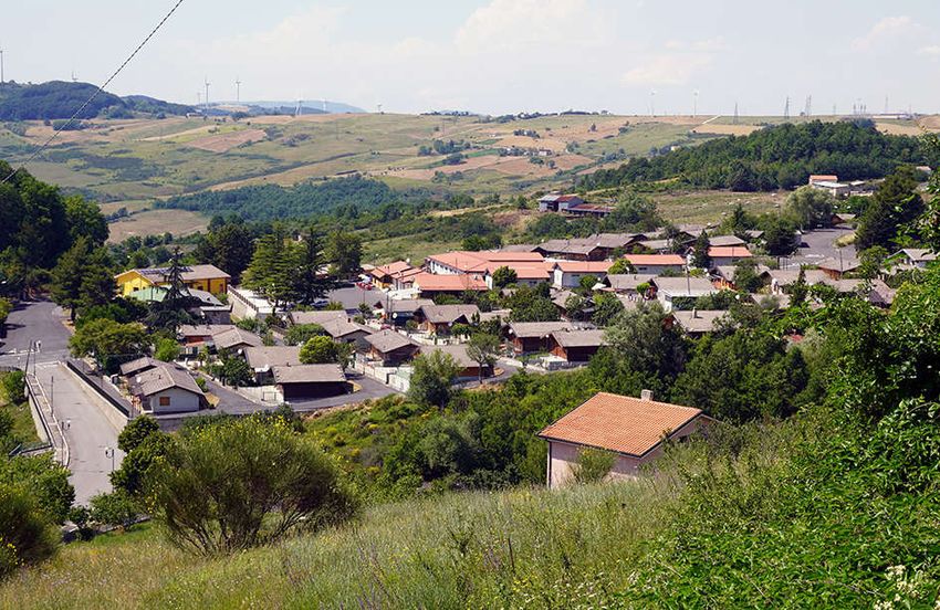
Geosciences 2021, 11, 6                                                                                             2 of 78

                                  region, 131 municipalities were classified of which nine were destroyed, 63 seriously
                                  damaged and 59 damaged [5–7].
                                       The earthquake also caused several striking effects on the natural environment
                                  including extensive coseismic surface faulting, observed between Lioni (Avellino) and
                                  San Gregorio Magno (Salerno) [8–18]. Moreover, over 200 landslides occurred, the most
                                  devasting hit the territories of Calitri in the urban center [11,19–22], Caposele
                                  (Buoninventre landslide) and Senerchia (Serra d’Acquara landslide) (Figure 2) [11,23];
                                  also, widespread soil fracturing was observed, and minor liquefaction effects [24–27].
                                  Furthermore, the coseismic faulting of the regional karst aquifer induced important
                                  hydrological variations in the springs of Caposele and Cassano Irpino [25] (Table 1).
                                       Forty years after the 1980 earthquake, we decided to record, through a photographic
                                  reportage, the state of the rebuilding, the urban changes that the earthquake had induced
                                  mainly in the epicenter and near field areas. This study represents a realistic
                                  documentation of what has been achieved over all these years, even with the considerable
                                  state economic funding, and the resilience of each community [28]. The study of the
                                  various localities portrayed is accompanied by a detailed bibliography starting from 1981
                                  until today.

                          Figure 1. Isoseismal Map of the 23 November 1980 Irpinia-Basilicata earthquake [1].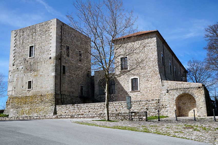
Geosciences 2021, 11, 6                                                                                                       3 of 78

      Figure 2. Environmental effects induced in the epicentral area by the 23 November 1980 Irpinia-Basilicata earthquake [21].
      The Ortophoto image from Google Earth.

      Table 1. The table contains the visited localities, their geographic coordinates and MCS and ESI intensity with the most
      significant environmental effects observed after the 1980 earthquake (SF surface fault; F fractures, L landslide, SC Soil
      Compaction, HC Hydrological Changes, LQ Liquefaction) [1–3,11,12,14,19–23,25–27].

                                                                                            ESI07
             Locality                  Lat.            Long.       (MCS) Intensity                       Environmental Effects
                                                                                          Intensity
    Castelnuovo di Conza           40.819091°       15.319704°             X                  8                   SF, L, F
   Conza della Campania            40.870562°       15.330818°             X                  9                   L, F, SC
           Laviano                 40.786800°       15.309247°             X                  9                   SF, F, L
            Lioni                  40.877996°       15.189476°             X                  8                L, SF, LQ, SC
   S. Angelo dei Lombardi          40.927716°       15.177733°             X                  8            L, temporary lake, F
        Santomenna                 40.808495°       15.321044°             X                  -                     L, F
           Balvano                 40.650928°       15.511861°            IX                  7                       L
          Calabritto               40.650928°       15.511861°            IX                  9                 SF, L, F, HC
          Quaglietta               40.745299°       15.235847°            IX                  9                     L, F
          Caposele                 40.815372°       15.220236°            IX                 10                L, SF, SC, HC
    Guardia dei Lombardi           40.953346°       15.209175°            IX                  8                     L, F
        Pescopagano                40.835588°       15.399507°            IX                  8                     L, F
    San Mango sul Calore           40.963896°       14.975828°            IX                  8                     L, F
    San Michele di Serino          40.876228°       14.855731°            IX                  6                    F, LQ
          Senerchia                40.740248°       15.203956°            IX                  9                 SF, L, F, LQ
            Teora                  40.852752°       15.253197°            IX                  6                       F
    Torella dei Lombardi           40.940058°       15.114519°            IX                  8                       F
           Colliano                40.725860°       15.291517°          VIII-IX             9–10                  SF, F, L
    Romagnano al Monte             40.628289°       15.456647°          VIII-IX               -                     L, F
          Salvitelle               40.591196°       15.459109°          VIII-IX               -                     F, L
           Avellino                40.916753        14.797924°           VIII                 -                     F, L
Geosciences 2021, 11, 6                                                                                          4 of 78

              Calitri      40.899432°      15.439435°           VIII               8                 L, F, LQ
             Bisaccia      41.013215°      15.375352°           VIII               8                 L, F, SC

                          2. Discussion
                                The photographic journey, carried out in the last five years, includes the
                          documentation of the villages almost completely destroyed or seriously damaged (Figure
                          3), with damage levels evaluated at I ≥ VIII MCS, Table 1): Castelnuovo di Conza (Figures
                          4–9), Conza della Campania (Figures 10–18), Laviano (Figures 19–22), Lioni (Figures 23–
                          28), Santomenna (Figures 29–33), Sant’Angelo dei Lombardi (Figures 34–39), Balvano
                          (Figures 40–43), Caposele (Figures 44–47), Calabritto-Quaglietta (Figures 48–53), San
                          Mango sul Calore (Figures 54–58), San Michele di Serino (Figures 59–65), Pescopagano
                          (Figures 66–70), Guardia dei Lombardi (Figures 71–74), Torella dei Lombardi (Figures 75–
                          79), Colliano (Figures 80–85), Romagnano al Monte (Figures 86–89), Salvitelle (Figures 90–
                          94), Senerchia (Figures 95–99) and Teora (Figures 100–104) [1,2,4,7,29]. In some cases, we
                          also took into account the preliminary seismic microzonation maps drawn up by the PFG
                          of CNR (Finalized Geodynamic Project (PFG) of the National Research Council (CNR),
                          the first major national project for seismic risk assessment and reduction), which provided
                          useful indications for reconstruction [29]. Moreover, two others towns, Bisaccia (Figures
                          105–108) and Calitri (Figures 109–114), although characterized by a lower intensity (I =
                          VIII MCS), have been added to our study due to the different pathways for reconstruction,
                          despite having both serious hydrogeological problems. Bisaccia has been often affected
                          by landslides, due to its geological formations, mostly made by conglomerates resting on
                          varicolored clays; indeed it was among the villages admitted to consolidation as early as
                          1917. Nowadays there are two Bisaccia villages: the old, ancient village recovered around
                          the ducal castle and the new Bisaccia of the ‘Piano di Zona’, the latter almost completely
                          rebuilt according to the urban plan drawn up by the architect Aldo Loris Rossi. Regards
                          Calitri, it was built on the top of a hill made of sandstone and conglomerate rocks, with
                          the middle-lower slopes made of intensely tectonized clay-rich units; therefore, it was
                          often affected by landslides. A great landslide occurred due to the 1980 earthquake,
                          approximately 850 m long and up to 100 m deep; it had terrible consequences on the urban
                          and road structure of the village [19]. Moreover, other significant coseismic environmental
                          effects occurred such as fracturing and liquefaction phenomena. Further landslides
                          occurred in Calitri due to the 1694, 1805, 1910 and 1930 earthquakes [1,7,11,21,22,29–31].
                          We also added the Avellino city (Figures 115–119), because it is one of the largest cities in
                          Campania, with level of damage I = VIII [32].
                                In this photographic reportage, we have deliberately chosen not to reproduce the
                          tragic images of the catastrophe, destruction, death of the places visited, that characterized
                          all the front pages of the newspapers of the time (e.g., Figure 3) [33]. We have chosen to
                          show the current, rebuilt urban centers.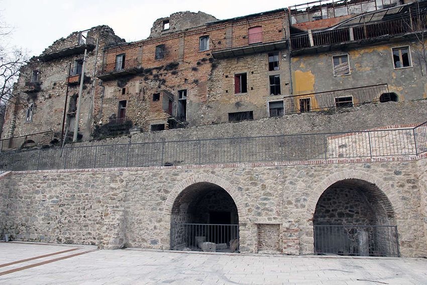
Geosciences 2021, 11, 6                                                                                         5 of 78

                          Figure 3. The front page of “Il Mattino” newspaper (26 November 1980) transformed by Andy
                          Warhol into a pop art manifesto [33].

                                We analyzed the reconstruction through the representative buildings as the churches,
                          the town halls, the sports centers. In some cases, there are pictures of temporary villages,
                          generally made of wooden houses, where people lived for many years waiting for the
                          final accommodation, now used for local tourism. Almost all the villages were rebuilt in
                          the same place despite some of them were completely razed to the ground not only by the
                          earthquake but also by bulldozers that destroyed everything, even more than necessary.
                                The buildings of the old urban centers were mostly made in natural stone or baked
                          bricks with poor mortar and wooden floors while the rebuilding involved reinforced con-
                          crete buildings, earthquake-proof. The new urban centers were rebuilt with wide roads
                          and outsized areas for new housing compared to the current number of inhabitants, that
                          over the last forty years has decreased dramatically, especially for the most internal areas.
                                As mentioned above, all of the villages affected by the earthquake were rebuilt in
                          situ, with the exception of Conza della Campania, Romagnano al Monte and Bisaccia. For
                          Conza della Campania, a town almost completely destroyed by the earthquake with a
                          high number of deaths (184 victims), the political choice of the urban center relocation
                          prevailed, supported also by the results of the numerous geological surveys some of
                          which also emphasized local amplification phenomena due to morphology. Indeed,
                          Conza was built on two small hills made by clay and sandy clay in the lower part, con-
                          glomerates with sands and sandstones in the middle part, and conglomerates of middle-
                          low resistance in the upper part. The 1980 earthquake induced in this village several dif-
                          ferent environmental effects such as landslides, ground cracks and ground settlement.
                          Moreover, this choice was also due to the historical memory of the destruction suffered
                          by the community in past earthquakes (1466, 1517,1694, 1732 and 1930 seismic events)
                          [7,18,29–31,34]. At present two Conza villages f coexist: the ancient village recovered and
                          enhanced with the creation of an archaeological park that preserves the remains of the
                          ancient Roman ‘Compsa’; and the new Conza, built in Piano delle Briglie, 4 km far from
                          the original nucleus where the topography of this flat area ensured safer conditions. This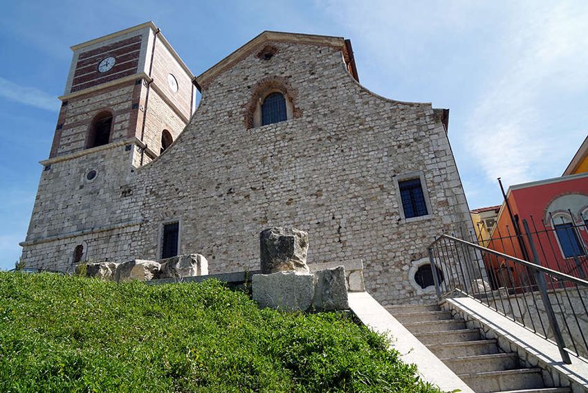
Geosciences 2021, 11, 6 6 of 78
is a modern village characterized by earthquake-proof houses and wide roads, designed
by the architect Beguinot of the University of Naples, [35–38].
Even for Romagnano al Monte, a small village in the Salerno province with only 370
inhabitants, located 650 metres a.s.l., overlooking the gorges of the Platano River, a few
kilometres from the epicentre of the 1980 earthquake, the political decision to relocate pre-
vailed. The main reason was due to the declared inhabitability of 446 residential units,
after the earthquake, that also caused the collapse of some churches and heavy damage to
the town hall. The geomorphological and geological assessment, that accentuated the seis-
mic shaking, also contributed to the choice in the reconstruction process. The old town, in
fact, is located at the highest point on the ridge and along the slopes are frequent phenom-
ena of rock fall caused by the high degree of fracturing bedrock.
The village was evacuated and abandoned becoming a “ghost town” [39]. The new
town was located in Ariola, 2 km from the old center, in a less panoramic position, but
providing more convenient access for the inhabitants.
More complex and longer is the history of Bisaccia’s relocation. The village located
at 860 m a.s.l., was affected by landslides due to the geological conditions on which it
stands and was already destroyed by historical earthquakes (1694 1732, 1930 and 1980
seismic events). These aspects have heavily conditioned its rebuilding. The 1980 earth-
quake, once again highlighted the territory’s extremely unstable conditions, so the Mu-
nicipal Administrations opted for the reconstruction of the village in another site, more
stable from a geological point of view, called “Piano di Zona”, which was already identi-
fied in a previous urban planning, following the 1930 earthquake [7,40,41].
As a matter of fact, there are currently two Bisaccia towns: the old one, an ancient
village recovered around the ducal castle; and the new Bisaccia of the Piano di Zona, the
latter almost completely rebuilt according to the urban planning drawn up by architect
Aldo Loris Rossi [42].
About the other villages we can say that among those among those which have de-
cided to rebuild in situ, some of them have chosen the recovery or rebuilding of the old
urban center, respecting the original architectural design, combined with new buildings
in the expansion areas.
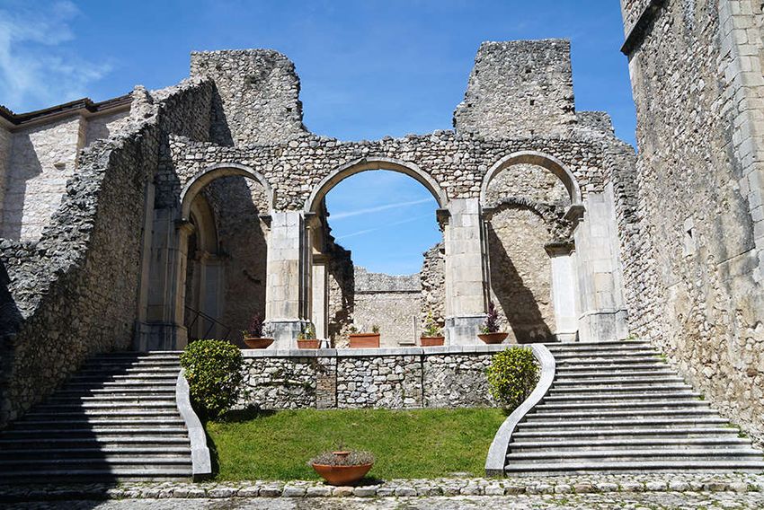
Among these we mention certainly Sant’Angelo dei Lombardi, with a careful recon-
struction of the historical centre and the Abbey of Goleto (Figure 36) [7,29,31,43]; Calitri
despite the historical large landslide triggered by the earthquakes (Figure 110) [7,29];
Guardia dei Lombardi (Figure 73) [7,29]; Torella dei Lombardi [7,29];(Figure 75); Caposele
[29,34]; Lioni (Figure 28); Balvano (Figure 41); Pescopagano (Figure 66); and Quaglietta
(Figure 53), whose medieval village has been recovered to transform it into an “albergo
diffuso” (“scattered hotel”) for tourism purposes [34,44].
Even Senerchia, which has been currently rebuilt, tries to recover the remaining
houses of the ancient village built on the solid calcareous substratum (Figure 98) [7,29,34].
In all the other villages the new buildings are predominant with some valuable innovative
edifices such as the town hall of Lioni (Figure 25), a modern and functional building real-
ized by the architect Verderosa, or in Balvano where the artists Boffo and Eibl designed
the houses, or architectural structures often in contrast with the original planning of the
village (Figures 42 and 43).
Unfortunately, in many cases during the rebuilding process the identity of Apennine
villages such as Laviano (Figures 19 and 22), San Michele di Serino (Figure 62), Castel-
nuovo di Conza (Figure 5), Santomenna (Figure 30), where the new buildings prevail over
the old ones, was lost, becoming only “rebuilt villages”.
Geosciences 2021, 11, 6                                                                                               7 of 78

                     Figure 4. Original map of the seismic microzonation of Castelnuovo di Conza according to [29].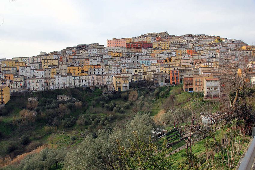
Geosciences 2021, 11, 6                                                                                                       8 of 78

      Figure 5. Castelnuovo di Conza: overview of the new village completely rebuilt after the1980 earthquake (photos by
      [35,36]).

      Figure 6. Castelnuovo di Conza: detail of the new village completely rebuilt after the1980 earthquake (photos by [35,36]).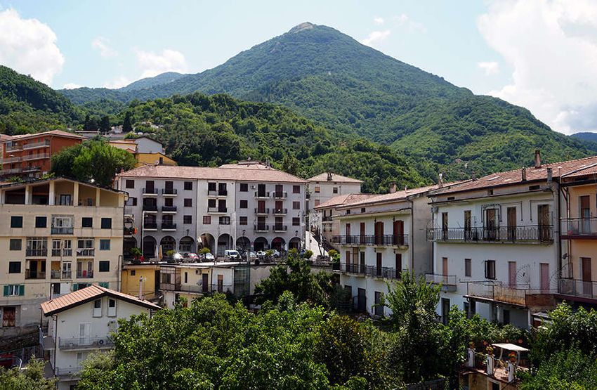
Geosciences 2021, 11, 6                                                                                                     9 of 78

                              Figure 7. Castelnuovo di Conza: the new sports hall (photos by [35,36]).

                                                                                                                      .
      Figure 8. Castelnuovo di Conza: Temporary village, consisting of wooden chalets, built immediately after the 1980 earth-
      quake and still used today (photos by [35,36]).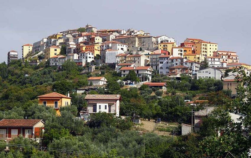
Geosciences 2021, 11, 6                                                                                            10 of 78

                          Figure 9. Castelnuovo di Conza: detail of new reinforced concrete buildings (photos by [35,36]).
Geosciences 2021, 11, 6 11 of 78
Figure 10. Original map of the seismic microzonation of Conza della Campania according to [29].Geosciences 2021, 11, 6 12 of 78
Figure 11. Conza della Campania: overview of the old village destroyed by the 1980 earthquake (photos by [35,36]).
Figure 12. Conza della Campania: old village with ruins of houses after the 1980 earthquake (photos by [35,36]).Geosciences 2021, 11, 6 13 of 78
Figure 13. Conza della Campania: old village with houses rebuilt after the 1980 earthquake (pho-
tos by [35,36]).Geosciences 2021, 11, 6 14 of 78
Figure 14. Conza della Campania: old village with the Archaeological Park realized a few years ago for the tourists (photos
by [35,36]).
Figure 15. Conza della Campania: detail of the Archaeological Park (photos by [35,36]).Geosciences 2021, 11, 6 15 of 78
Figure 16. Conza della Campania: temporary village, consisting of wooden housing, built immediately after the earth-
quake of 1980 and now almost completely abandoned (photos by [35,36]).
Figure 17. Conza della Campania: new village with the new Cathedral “Concattedrale di Santa Maria Assunta” in the
center of village built after the 1980 earthquake (photos by [35,36]).Geosciences 2021, 11, 6 16 of 78
Figure 18. Conza della Campania: panoramic view of the new Conza built in Piano delle Briglie locality, 4 km far from the
original nucleus of the old Conza (photos by [35,36]).
Figure 19. Laviano: the village completely rebuilt after the 1980 earthquake (photos by [35,36]).Geosciences 2021, 11, 6 17 of 78
Figure 20. Laviano: the new “Chiesa Madre” (photos by [35,36]).
Figure 21. Laviano: the new Town Hall of Laviano (photos by [35,36]).Geosciences 2021, 11, 6 18 of 78
Figure 22. Laviano: Piazza della Repubblica (photos by [35,36]).
Figure 23. Lioni: one of the first buildings built in 1985, the “Bergamo condominium” is in reinforced concrete, built thanks
to the solidarity of the inhabitants of Bergamo (Northern Italy) (photos by [35,36]).Geosciences 2021, 11, 6 19 of 78
Figure 24. Lioni: a detail of the “Bergamo condominium”, the recent murales was done to remember the solidarity of the
people forty years after the catastrophic earthquake (photos by [35,36]).
Figure 25. Lioni: part of modern Town Hall built by the architect A. Verderosa (1984–1994) (photos by [35,36]).Geosciences 2021, 11, 6 20 of 78
Figure 26. Lioni: modern bus station (photos by [35,36]).
Figure 27. Lioni: the new sports facilities (photos by [35,36]).Geosciences 2021, 11, 6 21 of 78
Figure 28. Lioni: restored Church and bell tower of S. Maria Assunta (photos by [35,36]).Geosciences 2021, 11, 6 22 of 78
Figure 29. Santomenna: overview of the village completely rebuilt (photos by [35,36]).
Figure 30. Santomenna: the center of the village completely rebuilt (photos by [35,36]).Geosciences 2021, 11, 6 23 of 78
Figure 31. Santomenna: a detail of the new buildings (photos by [35,36]).
Figure 32. Santomenna: the new Town Hall in reinforced concrete (photos by [35,36]).Geosciences 2021, 11, 6 24 of 78
Figure 33. Santomenna: S. Maria delle Grazie church (photos by [35,36]).
Figure 34. Sant’Angelo dei Lombardi: original map of the seismic microzonation according to [29].Geosciences 2021, 11, 6 25 of 78
Figure 35. Sant’Angelo dei Lombardi: the historical center with the Town Hall, reconstructed taking into account the orig-
inal urban design (photos by [35,36]).
Figure 36. Sant’Angelo dei Lombardi: the remains of the Goleto Abbey (photos by [35,36]).Geosciences 2021, 11, 6 26 of 78
Figure 37. Sant’Angelo dei Lombardi: Archdiocese of Sant’Angelo dei Lombardi in the historical center: (photos by
[35,36]).
Figure 38. Sant’Angelo dei Lombardi: Castle of the Imperials of Sant’Angelo dei Lombardi in the Historical center (photos
by [35,36]).Geosciences 2021, 11, 6 27 of 78
Figure 39. Sant’Angelo dei Lombardi: overview of new buildings and the football field (photos by [35,36]).
Figure 40. Balvano: Panoramic view with the Castle in the foreground (photos by [35,36]).Geosciences 2021, 11, 6 28 of 78
Figure 41. Balvano: overview of new buildings (photos by [35,36]).
Figure 42. Balvano: the new buildings details of the architecture by R. Boffo and K. Eibl (photos by [35,36]).Geosciences 2021, 11, 6 29 of 78
Figure 43. Balvano: the new buildings details of the architecture by R. Boffo and K. Eibl (photos by [35,36]).Geosciences 2021, 11, 6 30 of 78
Figure 44. Caposele: the Town Hall in the historical center (photos by [35,36]).Geosciences 2021, 11, 6 31 of 78
Figure 45. Caposele: the historical center with the new buildings reconstructed taking into account the original urban
design (photos by [35,36]).
Figure 46. Caposele: the historical center with the new buildings reconstructed taking into account the original urban
design (photos by [35,36]).Geosciences 2021, 11, 6 32 of 78
Figure 47. Caposele: the historical center with artistic murals (photos by [35,36]).Geosciences 2021, 11, 6 33 of 78
Figure 48. Calabritto: panoramic view of the village completely rebuilt (photos by [35,36]).
Figure 49. Calabritto: The new Church of Santissima Trinità (photos by [35,36]).Geosciences 2021, 11, 6 34 of 78
Figure 50. Calabritto: “Largo 23 November 1980”—Memorial dedicated to the earthquake victims (photos by [35,36]).
Figure 51. Quaglietta: Panoramic view of the castle and its medieval village completely restored after the 1980 hearth-
quake. Currently the medieval village is a tourist attraction as “albergo diffuso” (photos by [35,36]).Geosciences 2021, 11, 6 35 of 78
Figure 52. Quaglietta: detail of the medieval village (photos by [35,36]).Geosciences 2021, 11, 6 36 of 78
Figure 53. Quaglietta: detail of the medieval village (photos by [35,36]).Geosciences 2021, 11, 6 37 of 78
Figure 54. Original map of the seismic microzonation of San Mango sul Calore according to [29].Geosciences 2021, 11, 6 38 of 78
Figure 55. San Mango sul Calore: Panoramic view of the village completely rebuilt after the 1980 earthquake (photos by
[35,36]).
Figure 56. San Mango sul Calore: the new Church of Santa Maria degli Angeli (photos by [35,36]).
Figure 57. San Mango sul Calore: “villaggio italo-canadese” new homes built with the help of Canadians (photos by
[35,36]).Geosciences 2021, 11, 6 39 of 78
Figure 58. San Mango sul Calore: “Villaggio S. Stefano”. Temporary village, consisting of wooden chalets, built immedi-
ately after the 1980 earthquake (photos by [35,36]).
Figure 59. Original map of the seismic microzonation of San Michele di Serino according to [29].Geosciences 2021, 11, 6 40 of 78
Figure 60. San Michele di Serino: “Mariconda” palace facade, one of the few historical facades not destroyed by the 1980
earthquake (photos by [35,36]).
Figure 61. San Michele di Serino: the new municipal building (photos by [35,36]).Geosciences 2021, 11, 6 41 of 78
Figure 62. San Michele di Serino: new reinforced concrete buildings (photos by [35,36]).
Figure 63. San Michele di Serino: the new Church of San Michele Arcangelo (photos by [35,36]).Geosciences 2021, 11, 6 42 of 78
Figure 64. San Michele di Serino: the monument to the victims of the 1980 earthquake (photos by
[35,36]).Geosciences 2021, 11, 6 43 of 78
Figure 65. San Michele di Serino: detail of Cotone Street in which there were phenomena liquefaction triggered by the
earthquake [22], (photos by [35,36]).
Figure 66. Pescopagano: a panoramic view of the new village (photos by [35,36]).
Figure 67. Pescopagano: panoramic view of a part of village (photos by [35,36]).Geosciences 2021, 11, 6 44 of 78
Figure 68. Pescopagano: the new Town Hall of village (photos by [35,36]).Geosciences 2021, 11, 6 45 of 78
Figure 69. Pescopagano: “Porta della Sibilla” into the historical centre (photos by [35,36]).Geosciences 2021, 11, 6 46 of 78
Figure 70. Pescopagano: ruins of the medieval castle (photos by [35,36]).
Figure 71. Guardia dei Lombardi: panoramic view of the new village (photos by [35,36]).Geosciences 2021, 11, 6 47 of 78
Figure 72. Guardia dei Lombardi: the restored Church of Santa Maria delle Grazie (photos by
[35,36]).Geosciences 2021, 11, 6 48 of 78
Figure 73. Guardia dei Lombardi: the restored historical centre (photos by [35,36]).Geosciences 2021, 11, 6 49 of 78
Figure 74. Guardia dei Lombardi: the new Town Hall of village (photos by [35,36]).Geosciences 2021, 11, 6 50 of 78
Figure 75. Torella dei Lombardi: the restored castle of Ruspoli di Candriano (photos by [35,36]).Geosciences 2021, 11, 6 51 of 78
Figure 76. Torella dei Lombardi: the new Church of S. Maria del Popolo (photos by [35,36]).Geosciences 2021, 11, 6 52 of 78
Figure 77. Torella dei Lombardi: stone plaque to remember the victims of the 1980 earthquake
(photos by [35,36]).
Figure 78. Torella dei Lombardi: details of the new buildings (photos by [35,36]).
Figure 79. Torella dei Lombardi: details of the new buildings (photos by [35,36]).Geosciences 2021, 11, 6 53 of 78
Figure 80. Colliano: the new Town Hall of the village (photos by [35,36]).
Figure 81. Colliano: modern access structure with lift to Piazza Epifani (photos by [35,36]).Geosciences 2021, 11, 6 54 of 78
Figure 82. Colliano: New parking area of the Epifani Square (photos by [35,36]).Geosciences 2021, 11, 6 55 of 78
Figure 83. Colliano: New Epifani Square (photos by [35,36]).
Figure 84. Colliano: detail of the restored historical centre (Church of Santa Maria del Borgo) (photos by [35,36]).Geosciences 2021, 11, 6 56 of 78
Figure 85. Colliano: new residential settlement known as “Piano di zona” (photos by [35,36]).
Figure 86. Romagnano al Monte: panoramic view of the village, completely abandoned after 1980 earthquake, now ghost
town (photos by [35,36]).Geosciences 2021, 11, 6 57 of 78
Figure 87. Romagnano al Monte: details of the old village completely abandoned after 1980 earthquake, (photos by [35,36]).
Figure 88. Romagnano al Monte: the Church of Maria SS. del Rosario in the new town, located in Ariola, 2 km from the
old center (photos by [35,36]).Geosciences 2021, 11, 6 58 of 78
Figure 89. Romagnano al Monte: details of new buildings in the new town (photos by [35,36]).
Figure 90. Salvitelle: Panoramic view of the new village (photos by [35,36]).Geosciences 2021, 11, 6 59 of 78
Figure 91. Salvitelle: the new Town Hall of the village (photos by [35,36]).
Figure 92. Salvitelle: new buildings mainly in reinforced concrete (photos by [35,36]).Geosciences 2021, 11, 6 60 of 78
Figure 93. Salvitelle: details of new buildings (photos by [35,36]).
Figure 94. Salvitelle: plaque of a new street that remember the earthquake of 23 November 1980 (photos by [35,36]).Geosciences 2021, 11, 6 61 of 78
Figure 95. Senerchia: Overview of the remains of the old village (photos by [35,36]).Geosciences 2021, 11, 6 62 of 78
Figure 96. Senerchia: a small street of the old village (photos by [35,36]).Geosciences 2021, 11, 6 63 of 78
Figure 97. Senerchia: the new village, “Piazza 23 Novembre 1980” and monument dedicated to the
earthquake victims (photos by [35,36]).Geosciences 2021, 11, 6 64 of 78
Figure 98. Senerchia: details of the new buildings (photos by [35,36]).
Figure 99. Senerchia: new school complex (photos by [35,36]).Geosciences 2021, 11, 6 65 of 78
Figure 100. Teora: panorama of the reconstructed village (photos by [35,36]).Geosciences 2021, 11, 6 66 of 78
Figure 101. Teora: the new Church of S. Nicola di Mira (photos by [35,36]).
Figure 102. Teora: new school complex and Town Hall (photos by [35,36]).
Figure 103. Teora: part of the restored historical centre (photos by [35,36]).Geosciences 2021, 11, 6 67 of 78
Figure 104. Teora: new reinforced concrete houses (photos by [35,36].Geosciences 2021, 11, 6 68 of 78
Figure 105. Bisaccia: the new village (Piano di Zona) with new Church of Sacro Cuore built by the
architect A. L. Rossi, 1998 (photos by [41]).
Figure 106. Bisaccia: the new village (Piano di Zona) with a details of some reinforced concrete buildings realized by
architect A. L. Rossi, (photos by [41]).
Figure 107. Bisaccia: the new village (Piano di Zona) with a detail of the new reinforced concrete homes designed by the
architect A. L. Rossi, (photos by [41]).Geosciences 2021, 11, 6 69 of 78
Figure 108. Bisaccia: the new village (Piano di Zona) with the remains of the new social housing still to be completed
(Istituto Autonomo Case Popolari-IACP). A part of them has been demolished in 2020 (photos by [41]).
Figure 109. Calitri: panoramic view of the village (photos by [35,36]).Geosciences 2021, 11, 6 70 of 78
Figure 110. Original map of the seismic microzonation of Calitri according to [29].Geosciences 2021, 11, 6 71 of 78
Figure 111. Calitri: historical centre, remains of some buildings that were recovered after the 1980 earthquake (photos by
[35,36]).
Figure 112. Calitri: historical centre, remains of some buildings that were recovered after the 1980 earthquake (photos by
[35,36]).Geosciences 2021, 11, 6 72 of 78
Figure 113. Calitri: panoramic view of new buildings (photos by [35,36]).
Figure 114. Calitri: panoramic view of the new constructions, the historical centre and the remains of the castle on the hill
(photos by [35,36]).Geosciences 2021, 11, 6 73 of 78
Figure 115. Avellino: panoramic view of the town (photos by [35,36]).
Figure 116. Avellino: Rifugio Street after 1980 earthquake (cortesy of F. Capossela).Geosciences 2021, 11, 6 74 of 78
Figure 117. Avellino: Rifugio Street today completely reconstructed (photos by [35,36]).Geosciences 2021, 11, 6 75 of 78
Figure 118. Avellino: “Piazza del popolo” after the 1980 earthquake (courtesy of F. Capossela).
Figure 119. Avellino: “Piazza del Popolo” today completely reconstructed (photos by [35,36]).
3. Conclusions
The rebuilding process, in many localities, has been driven by microzonation maps
drawn up as part of the Finalized Geodynamic Project (PFG) of the National Research
Council (CNR), created immediately after the 1980 earthquake [29].
The seismic microzonation maps show the areas with different seismic characteris-
tics, illustrating the morphological structure of the territory, the distribution of the build-
ing heritage existing in 1980, and in some cases, the level of damage suffered due the 1980Geosciences 2021, 11, 6 76 of 78
event and provide suggestions for reconstruction. We reported some examples of these
maps: Castelnuovo di Conza (Figure 4), Conza della Campania (Figure 11), S. Angelo dei
Lombardi (Figure 34), San Mango sul Calore (Figure 55), San Michele di Serino (Figure
60), Calitri (Figure 110).
However, the choices made for the reconstruction did not depend only on the geo-
logical assessment of the territory and therefore on the indications given by the microzon-
ing maps, but also on the urban and socio-economic context. Nevertheless, there has not
been a socio-economic redevelopment policy for the entire territory which, despite the
settlement of some important factories, is currently suffering from unemployment and
depopulation [45–49].
Our reportage is certainly not exhaustive, in fact there are still many other places that
have undergone considerable transformations during the reconstruction process. The im-
ages can guide the future urban development of ancient villages after a major destructive
seismic event, with a view to safeguarding the territory and cultural heritage. Even more
than this, documenting the rebuilding process in a large epicentral area reveals the human
legacy to the natural landscape, and our ability, or failure, to properly interpret the envi-
ronmental fate of a site. Often in the post-earthquake reconstruction process of 1980, in-
stead of taking into accounts the socio-economic, historical and geological local condi-
tions, different case by case for each affected village, the policy of rebuilding at any cost
has prevailed, even with buildings unsuitable for the context of the Apennine inland ar-
eas.
Author Contributions: Conceptualization, S.P. and E.S.; methodology, S.P.; software, R.N.; valida-
tion, R.N., G.A., G.G., E.S., A.M.M. and S.P.; formal analysis, S.P., E.S.; investigation, G.G., G.A.;
resources, R.N.; data curation, R.N., G.G., G.A.; writing—original draft preparation, S.P., G.G., R.N.,
A.M.M. and G.A.; writing—review and editing, R.N., G.G., G.A., A.M.M.; visualization, A.M.M.;
supervision, S.P.; project administration, E.S., S.P. All authors have read and agreed to the published
version of the manuscript.
Funding: This research received no external funding.
Acknowledgments: This manuscript is dedicated to all the inhabitants of these villages who expe-
rienced the terrible earthquake of 1980, but nevertheless have been able to recover with great dig-
nity.
Conflicts of Interest: The authors declare no conflict of interest. The funders had no role in the
design of the study; in the collection, analyses, or interpretation of data; in the writing of the man-
uscript, or in the decision to publish the results.
References
1. Postpischl, D.; Branno, A.; Esposito, E.; Ferrari, G.; Marturano, A.; Porfido, S.; Rinaldis, V.; Stucchi, M. The Irpinia earthquake
of November 23, 1980. In Atlas of Isoseismal Maps of Italian Earthquakes; CNR-PFG: 1985 Bologna; Volume 114, pp. 152–157.
2. Rovida, A.; Locati, M.; Camassi, R.; Lolli, B.; Gasperini, P. CPTI15, the 2015 Version of the Parametric Catalogue of Italian
Earthquakes. INGV 2016. Available online: http://doi.org/10.6092/INGV.IT-CPTI15 (accessed on 15 October 2020).
3. Serva, L.; Esposito, E.; Guerrieri, L.; Porfido, S.; Vittori, E.; Comerci, V. Environmental Effects from some historical earthquakes
in Southern Apennines (Italy) and macroseismic intensity assessment. Contribution to INQUA EEE scale project. Quat. Int. 2007,
173–174, 30-44.
4. Gizzi, F.T.; Potenza, M.R. The scientific landscape of November 23rd, 1980 Irpinia Basilicata earthquake: Taking stock of (almost)
forty years of studies. Geosciences 2020, 10, 482.
5. Commissione Parlamentare d’Inchiesta Sulla Attuazione Degli Interventi per la Ricostruzione e lo Sviluppo dei Territori della
Basilicata e della Campania Colpiti dai Terremoti del Novembre 1980 e Febbraio 1981. Relazione Conclusiva e Propositiva. 1991,
Volume I. Available online: https://storia.camera.it/lavori/sedute/27-novembre-1990-bf-10-19901127-00-01 (accessed on 24
December 2020).
6. Proietti, G. “Dopo la Polvere”. Rilevazione Degli Interventi di Recupero Post-Sismico del Patrimonio Archeologico, Architettonico ed
Artistico delle Regioni Campania e Basilicata Danneggiato dal Terremoto del 23 Novembre 1980 e del 14 Febbraio 1981; Ministero per i
Beni Culturali e Ambientali: Rome, Italy, 1994; Volume 5.
7. Mazzoleni, D.; Sepe, M. (Eds.) Rischio Sismico, Paesaggio, Architettura: L’Irpinia Contributi per un Progetto; CRdC AMRA: Naples,
Italy, 2005.Geosciences 2021, 11, 6 77 of 78
8. Bollettinari, G.; Panizza, M. Una faglia di superficie presso San Gregorio Magno in occasione del sisma del 23/11/1980 in Irpinia.
Rend. Soc. Geol. Ital. 1981, 4, 135–136.
9. Cinque, A.; Lambiase, S.; Sgrosso, I. Su due faglie nell’alta valle del Sele legate al terremoto del 23.11.1980. Rend. Soc. Geol. Ital.
1981, 4, 127–129.
10. Carmignani, L.; Cello, G.; Cerrina Feroni, A.; Funiciello, R.; Klin, O.; Meccheri, M.; Patacca, E.; Pertusati, P.; Plesi, G.; Salvini, F.;
et al. Analisi del campo di fratturazione superficiale indotto dal terremoto Campano-Lucano del 23/11/1980. Rend. Soc. Geol. Ital.
1981, 4, 451–465.
11. Cotecchia, V. Ground deformations and slope instability produced by the earthquake of 23 November 1980 in Campania and
Basilicata. Geol. Appl. Idrogeol. 1986, 21, 31–100.
12. Pantosti, D.; Valensise, G. Faulting mechanism and complexity of the November 23, 1980, Campania-Lucania earthquake,
inferred from surface observations. J. Geophys. Res. 1990, 95, 319–341.
13. Westaway, R.; Jackson, J. Surface faulting in the southern Italian Campania-Basilicata earthquake of 23 November 1980. Nature
1984, 312, 436–438.
14. Blumetti, A.M.; Esposito, E.; Ferreli, L.; Michetti, A.M.; Porfido, S.; Serva, L.; Vittori, E. Ground effects of the 1980 Irpinia
earthquake revisited: Evidence for surface faulting near Muro Lucano. In Large-scale Vertical Movements and Related Gravitational
Processes; Dramis, F.; Farabollini, P.; Molin, P., Eds.; Studi Geol. Camerti: Camerino, Italy, 2002; pp. 19–27.
15. Bernard, P.; Zollo, A. The Irpinia (Italy) 1980 earthquake: Detailed analysis of a complex normal faulting. J. Geophys. Res. 1989,
94, 1631–1648.
16. Ascione, A.; Mazzoli, S.; Petrosino, P.; Valente, E. A decoupled kinematic model for active normal faults: Insights from the 1980,
MS = 6.9 Irpinia earthquake, southern Italy. Geol. Soc. Am. Bull. 2013, 125, 1239–1259.
17. Galli, P. Roman to Middle Age Earthquakes Sourced by the 1980 Irpinia Fault: Historical, Archaeoseismological, and
Paleoseismological Hints. Geosciences 2020, 10, 286.
18. Matano, F.; Di Nocera, S.; Criniti, S.; Critelli, S. Geology of the Epicentral Area of the November 23, 1980 Earthquake (Irpinia,
Italy): New Stratigraphical, Structural and Petrological Constrains. Geosciences 2020, 10, 247.
19. Del Prete, M.; Trisorio Liuzzi, G. Risultati dello studio preliminare della frana di Calitri (AV) mobilitata dal terremoto del
23/11/1980. Geol. Appl. Idrogeol. 1981, 16, 153–165.
20. Esposito, E.; Gargiulo, A.; Iaccarino, G.M.; Porfido, S. Distribuzione dei fenomeni franosi riattivati dai terremoti dell’Appennino
meridionale. Censimento delle frane del terremoto del 1980. In Proceeding Internal Convention on Prevention of Hydrogeological
Hazards; CNR(IRPI): Torino, Italy, 1998; pp. 409–429.
21. Porfido, S.; Esposito, E.; Michetti, A.M.; Blumetti, A.M.; Vittori, E.; Tranfaglia, G.; Guerrieri, L.; Ferreli, L.; Serva, L. Areal
distribution of ground effects induced by strong earthquakes in the Southern Apennines (Italy). Surv. Geophys. 2002, 23, 529–
562.
22. Porfido, S.; Esposito, E.; Guerrieri, L.; Vittori, E.; Tranfaglia, G.; Pece, R. Seismically induced ground effects of the 1805, 1930
and 1980 earthquakes in the Southern Apennines. Boll. Soc. Geol. Ital. 2007, 126, 333–346.
23. Wasowski, J.; Pierri, V.; Pierri, P.; Capolongo, D. Factors controlling seismic susceptibility of the Sele valley slopes: The Case of
the 1980 Irpinia Earthquake Re-examined. Surv. Geophys. 2002, 23, 563–593.
24. Carulli, G.B.; Migliacci, A.; Onofri, R.; Porfido, S. Indagini geologiche ed in prospettiva sismica a S. Michele di Serino. Rend. Soc.
Geol. Ital. 1981, 161–164.
25. Cotecchia, V.; Salvemini, A. Correlation between seismic events and discharge variations at Caposele and Cassano Irpino
springs, with particular reference to the 23 November 1980 earthquake. [Correlazione fra eventi sismici e variazione di portata
alle sorgenti di Caposele e Cassano Irpino, con particolare riferimento al sisma del 23 Novembre 1980]. Geol. Appl. Idrogeol. 1981,
16, 167–192.
26. Galli, P. New empirical relationships between magnitude and distance for liquefaction. Tectonophysics 2000, 324, 169–187.
27. Esposito, E.; Pece, R.; Porfido, S.; Tranfaglia, G. Hydrological anomalies connected to earthquakes in Southern Apennines, Italy.
Nat. Hazards Earth Syst. Sci. EGS 2001, 1, 137–144.
28. Osservatorio permanente sul doposisma. Edizioni MIdA-2010, p.114. Available online:
http://www.laquilaemotion.it/idee/idee/osservatorio-permanente-sul-doposisma.html (accessed on 24 December 2020).
29. Siro, L.; Bigi, G.; Testoni, P., Luongo, G. Indagini di microzonazione sismica. In Intervento urgente in 39 Comuni della Campania e
della Basilicata colpiti dal terremoto del 23 novembre 1980; Pubbl. n. 492; CNR-PFG: Bologna, Italy, 1983; 221p.
30. Guarino, M. Verso una Nuova Qualità dell’abitare: La Riqualificazione dell’edilizia Residenziale Pubblica. Tesi di Dottorato di
Ricerca in Ingegneria delle Strutture e del Recupero Edilizio ed Urbano (2007–2010). Available online:
http://elea.unisa.it/jspui/handle/10556/156 (accessed on 24 December 2020).
31. Moscaritolo, G.I. Reconstruction as a Long-Term Process. Memory, Experiences and Cultural Heritage in the Irpinia Post-
Earthquake (November 23, 1980). Geosciences 2020, 10, 316.Geosciences 2021, 11, 6 78 of 78
32. Maresca, R.; Nardone, L.; Gizzi, F.T.; Potenza, M.R. Ambient noise HVSR measurements in the Avellino historical centre and
surrounding area (southern Italy). Correlation with surface geology and damage caused by the 1980 Irpinia-Basilicata
earthquake. Measurement 2018, 130, 211–222.
33. Artibrune. Dal 2011 Arte Eccetera Eccetera. Available online: https://www.artribune.com/attualita/2011/11/%E2%80%9Cfate-
presto%E2%80%9D-stratigrafia-di-un-titolo/ (accessed on 5 October 2020).
34. Scirè, E.; Siro, L.; Stucchi, M.; Gaiazzi, M. Geo-seismic investigations and urban planning after the Irpinia- 971 Basilicata 1980
earthquake: Part 1, the case of Caposele and Conza della Campania. Geol. Appl. Idrogeol. 1986, 21, 441–450.
35. Porfido, S.; Spiga, E. Ricostruzione 1980–2020 Ed; Blurb: San Francisco, CA, USA, 2020; Volume I, ISBN 978-1-71-571504-5.
36. Porfido, S.; Spiga, E. Ricostruzione 1980–2020 Ed; Blurb: San Francisco, CA, USA, 2020; Volume II, ISBN 978-1-71-572142-8.
37. Coletta, T. La Conservazione dei Centri Storici Minori Abbandonati. Il Caso Della Campania. Ph.D. Thesis, Università “Federico
II” Napoli, Naples, Italy, 2005.
38. Ventura, S. I ragazzi dell’Ufficio del Piano la ricostruzione urbanistica in Irpinia. In I frutti di Demetra, Bollettino di Storia
Ambientale; Donzelli: Roma, Italy, 2010; Volume 22.
39. Porfido, S.; Alessio, G.; Gaudiosi, G.; Nappi, R.; Spiga, E. The resilience of some villages 36 years after the Irpinia-Basilicata
(Southern Italy) 1980 earthquake. In Workshop on World Landslide Forum; Springer: Cham, Switzerland, 2017; doi:10.1007/978-3-
319-53483-1-15.
40. Porfido, S.; Spiga, E. Il terremoto del 23 novembre 1980: Ricostruzioni e abbandoni di alcuni paesi nell’Appennino meridionale.
The earthquake of November 23rd, 1980: Reconstructions and abandonments of some villages in the southern Apennines. In La
Città Altra Storia e Immagine della Diversità Urbana: Luoghi e Paesaggi dei Privilegi e del Benessere, dell’isolamento, del Disagio, della
Multiculturalità; Capano, F., Pascariello, M.I., Visone, M., Eds.; CIRICE: Napoli, Italy, 2018; ISBN 978-88-99930-03-5,
doi:10.6093/978-88-99930-03-5.
41. Spiga, E.; Porfido, S. Bisaccia Piano di Zona Ed; Blurb: San Francisco, CA, USA, 2020; ISBN 978-1-71-555296-1.
42. Locci, M.; Loris Rossi, A. La Concretezza dell’utopia; Testo & Immagine: Torino, Italy, 1997.
43. Scirè, E.; Siro, L.; Stucchi, M.; Gaiazzi, M. Geo-seismic investigations and urban planning after the Irpinia- Basilicata 1980
earthquake: Part 2, the case of S. Angelo dei Lombardi (Italy). Geol. Appl. Idrogeol. 1986, 21, 387–397.
44. Ventura, F. The long-term effects of the 1980 earthquake on the villages of southern Italy. Disasters 1984, 894, 11.
45. Alexander, D. Housing crisis after natural disasters: The aftermath of the November 1980 southern Italian earthquake. In
Geoforum; Elsevier: Amsterdam, The Netherlands, 1984; pp. 489–516.
46. Guadagno, L. Disastri Naturali e Vulnerabilità Sociale. Un’analisi del Terremoto in Campania. Ph.D. Thesis, Università degli
Studi del Sannio, Benevento, Italy, 2010.
47. Wyss, M.; Rosset, P. Near-Real-Time Loss Estimates for Future Italian Earthquakes Based on the M6.9 Irpinia Example.
Geosciences 2020, 10, 165.
48. Colucci, M.; Gallo, S. Campania in movimento-Rapporto sulle migrazioni interne in Italia. In Collana “ Fuori collana”; Società
editrice il Mulino: Bologna, Italy, 2020; p. 200, ISBN 978-88-15-28720-5.
49. Ricciardi, T. Avellino. L’Irpinia 40 anni dopo il terremoto, tra cambiamenti e amare continuità. In Rapporto Italiani nel Mondo
2020; Fondazione Migrantes, Roma, Italy, 2020; pp. 95–106.You can also read