Place recognition survey: An update on deep learning approaches - arXiv
←
→
Page content transcription
If your browser does not render page correctly, please read the page content below
1
Place recognition survey: An update on deep learning approaches
Tiago Barros, Ricardo Pereira, Luı́s Garrote, Cristiano Premebida, Urbano J. Nunes
Abstract—Autonomous Vehicles (AV) are becoming more ca- Internal Representation
pable of navigating in complex environments with dynamic
Loop Candidates
and changing conditions. A key component that enables these
Sensor Data
intelligent vehicles to overcome such conditions and become
more autonomous is the sophistication of the perception and
localization systems. As part of the localization system, place
recognition has benefited from recent developments in other per-
ception tasks such as place categorization or object recognition, Place Matching
arXiv:2106.10458v2 [cs.CV] 22 Jun 2021
namely with the emergence of deep learning (DL) frameworks.
This paper surveys recent approaches and methods used in Place Modeling Belief Generation
place recognition, particularly those based on deep learning. The
contributions of this work are twofold: surveying recent sensors Fig. 1. Generic place recognition pipeline with the following modules: place
such as 3D LiDARs and RADARs, applied in place recognition; modeling, belief generation and place mapping. Place modeling creates an
and categorizing the various DL-based place recognition works internal place representation. Place mapping is concerned with maintaining
into supervised, unsupervised, semi-supervised, parallel, and a coherent representation of places over time. And Belief generation, finally,
hierarchical categories. First, this survey introduces key place generates, based on the current place model and the map, loop candidates.
recognition concepts to contextualize the reader. Then, sensor
characteristics are addressed. This survey proceeds by elaborat-
ing on the various DL-based works, presenting summaries for
each framework. Some lessons learned from this survey include:
the importance of NetVLAD for supervised end-to-end learning;
the advantages of unsupervised approaches in place recognition,
namely for cross-domain applications; or the increasing tendency
of recent works to seek, not only for higher performance but also
for higher efficiency.
Index Terms—Place recognition, Deep Learning, Localization.
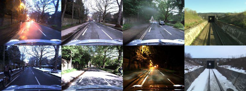
Fig. 2. Illustration of the seasonal environment changes. Images taken from
the Oxford Robotcar [1] and Nordland dataset [2].
I. I NTRODUCTION
Self-driving vehicles are increasingly able to deal with
unstructured and dynamic environments, which is mainly due − the same places exhibit significant appearance changes
to the development of more robust long-term localization and over time due to day-night variation, weather, seasonal
perception systems. A critical aspect of long-term localization or structural changes (as shown in Fig. 2);
is to guarantee coherent mapping and bounded error over − same places are perceived from different viewpoints or
time, which is achieved by finding loops in revisited areas. positions.
Revisited places are detected in long-term localization systems Solving these challenges is essential to enable robust place
by resorting to approaches such as place recognition and recognition and consequently long-term localization.
loop closure. Namely, place recognition is a perception based The primary motivation for writing this survey paper is to
approach that recognizes previously visited places based on provide an updated review of the recent place recognition
visual, structural, or semantic cues. approaches and methods since the publication of previous
Place recognition has been the focus of much research over surveys [3], [4]. The goal is, in particular, to focus on the
the last decade. The efforts of the intelligent vehicle and works that are based on deep-learning.
machine vision communities, including those devoted to place Lowry et al. [3] presented a comprehensive overview of
recognition, resulted in great achievements, namely evolving the existing visual place recognition methods up to 2016. The
towards systems that achieve promising performances in ap- work summarizes and discusses several fundamentals to deal
pearance changing and extreme viewpoint variation conditions. with appearance changing environments and viewpoint varia-
Despite the recent achievements, the fundamental challenges tions. However, the rapid developments in deep learning (DL)
remain unsolved, which occur when: and new sensor modalities (e.g., 3D LiDARs and RADARs)
− two distinct places look similar (also known as perceptual are setting unprecedented performances, shifting the place
aliasing); recognition state of the art from traditional (handcrafted-only)
feature extraction towards data-driven methods.
The authors are with the University of Coimbra, Institute of Systems A key advantage of these data-driven approaches is the end-
and Robotics, Department of Electrical and Computer Engineering, Portu-
gal. E-mail:{tiagobarros, ricardo.pereira, garrote, to-end training, which enables to learn a task directly from
cpremebida, urbano}@isr.uc.pt the sensory data without requiring domain knowledge for fea-
2

ture extraction. Instead, features are learning during training,      single location to an entire region of discrete locations [3]
using Convolutional Neural Networks (CNNs). These feature             (see examples in Fig. 2). The segments’ physical bounds
extraction approaches have been ultimately the driving force          can be defined, resorting to different segmentation criteria:
that has inspired recent works to use supervised, unsupervised,       time step, traveled distance, or appearance. In particular, the
or both learning approaches combined (semi-supervised) to             appearance criterion is widely used in place recognition. In
improve performance. The influence of DL frameworks in                such a case, a new place is created whenever the appearance
place recognition is, in particular, observable when considering      of the current location differs significantly from locations that
the vast amount of place recognition works published in the           were previously observed [3].
last few years that resort to such methods.
   On the other hand, a disadvantage of DL methods is the re-
                                                                      B. How are places recognized and remembered?
quirement of a vast amount of training data. This requirement
is in particular critical since the creation of suitable datasets        Place recognition is the process of recognizing places within
is a demanding and expensive process. In this regard, place           a global map, utilizing cues from surrounding environments.
recognition has benefited considerably from the availability of       This process is typically divided into three modules (as illus-
autonomous vehicle datasets, which are becoming more and              trated in Fig.1: place modeling, belief generation, and place
more realistic. Besides more realistic real-world conditions,         mapping.
also data from new sensor modalities are becoming available,             1) Place Modeling: Place modeling is the module that
for example, new camera types, 3D LiDARs, and, more re-               maps the data from a sensor space into a descriptor space. Sen-
cently, RADARs [5], [6]. This work does not address datasets          sory data from cameras, 3D LiDARs [12], [13] or RADARs
since this topic is already overviewed in other works such            [14] are used to model the surrounding environment, which is
as in [7] what place recognition concerns, and in [8] broader         achieved by extracting meaningful features.
autonomous driving datasets.                                             Feature extraction approaches have evolved immensely over
   The contribution of this work is to provide a comprehensive        the last decade. Classical approaches rely on handcrafted
review of the recent methods and approaches, focusing in              descriptors such as SWIFT [15], SURF [16], Multiscale Super-
particular on:                                                        pixel Grids [17], HOG [18] or bag-of-words [19], which are
   • the recent introduced sensors in the context of place            mainly build based on the knowledge of domain experts (see
      recognition, an outline of advantages and disadvantages         [3] for further understanding). On the other hand, DL-based
      is presented in Table I and outline is illustrated in Fig. 4;   techniques, namely CNNs, are optimized to learn the best
   • the categorization of the various DL-based works into su-        features for a given task [20]. With the increasing dominance
      pervised, unsupervised, semi-supervised and other frame-        of DL in the various perception tasks, also place recognition
      works (as illustrated in Fig. 3), in order to provide           slowly benefited from these techniques, using initially pre-
      to the reader a more comprehensive and meaningful               trained models from other tasks (e.g., object recognition [21]
      understanding of this topic.                                    or place categorization [22], [23]), and more recently using
   The remainder of this paper is organized as follows. Section       end-to-end learning techniques trained directly on place recog-
II is dedicated to the key concepts regarding place recogni-          nition tasks [24], [25].
tion. Section III addresses the supervised place recognition             2) Place Mapping: Place mapping refers to the process of
approaches, which include pre-trained and end-to-end frame-           maintaining a faithful representation of the physical world. To
works. Section V addresses the unsupervised place recognition         this end, place recognition approaches rely on various map-
approaches. Section VI addresses approaches that combine              ping frameworks and map update mechanisms. Regarding the
both supervised and unsupervised. Section VII addresses al-           mapping frameworks, three main approaches are highlighted:
ternative frameworks that resort to parallel and hierarchical         database [26], [27], topological [28]–[30] or topological-
architectures. Lastly, Section VIII concludes the paper.              metric [31], [32].
                                                                         Database frameworks are abstract map structures, which
        II. K EY CONCEPTS OF PLACE RECOGNITION                        store arbitrary amounts of data without any relation between
   This section introduces the fundamentals and key concepts          them. These frameworks are mainly used in pure retrieval tasks
of place recognition. Most of the concepts here discussed             and resort, for retrieval efficiency, to k-dimensional [33], [34],
have been already presented in [3] [9] [10] [11], but they are        Chow Liu trees [35] or Hierarchical Navigable Small World
concisely revisited in this section to contextualize the reader       (NSW) [36] to accelerate nearest neighbor search.
and thus facilitate the reading process.                                 Topological(-metric) maps, on the other hand, are graph-
   Thus, before diving into more details, some fundamental            based frameworks, which represent the map through nodes
questions have to be addressed beforehand. What is a ‘place’ in       and edges. The nodes represent places in the physical world,
the place recognition context? How are places recognized and          while the edges represent the relationships among the nodes
remembered? Moreover, what are the difficulties/challenges            (e.g., the similarity between two nodes). A node may represent
when places change over time?                                         one, or several locations, defining in the latter case a region in
                                                                      the physical world. The topological-metric map differs from
A. What is a place?                                                   pure topological in respect of how nodes relate i.e., while in
  Places are segments of the physical world that can have             pure topological maps no metric information is used in the
any given scale - at the limit, a place may represent a               edges; in topological-metric maps, nodes may relate with other
3

                                                Deep-learning-based Place recognition

         Supervised                          Unsupervised                  Semi-supervised                   Other Franmweks

      Pre-trained                    End-to-end                                                                    Hierarchical
                                                                                   Parallel framework
      framework                      framework                                                                     framework

Fig. 3. A taxonomy of recent DL-based place recognition approaches.

nodes through relative position, orientation, or metric distance      approaches, which can operate over extended areas in real-
[3]. An example of such a mapping approach is the HTMap               world conditions with unprecedented performances. Despite
approach [37].                                                        these achievements, the major place recognition challenges
   Regarding map updating, database frameworks usually are            remain unsolved, namely places with similar appearances;
not updated during operation time, while topological frame-           places that change in appearance over time; places that are
works can be updated. Update strategies include simple meth-          perceived from different viewpoints; and scalability of the
ods, which update nodes as loops occur [28], or more sophis-          proposed approaches in large environments.
ticated ones, where long- short-term memory-based methods                1) Appearance Change and Perceptual Aliasing:
are used [38].                                                        Appearance-changing environments and perceptual aliasing
   3) Belief Generation: The belief generation module refers          have been in particular the focus of much research. As
to the process of generating a belief distribution, which repre-      autonomous vehicles operate over extended periods, their
sents the likelihood or confidence of the input data matching a       perception systems have to deal with environments that
place in the map. This module is thus responsible to generate         change over time due to for example different weather or
loop candidates based on the belief scores, which can be              seasonal conditions or due to structural changes. While the
computed using methods based on frame-to-frame [39]–[41],             appearance changing problem is originated when the same
sequence of frames [14], [42]–[44], hierarchical, graphs [45]         place changes over time in appearance, perceptual aliasing
or probabilistics [46]–[48].                                          is caused when different places have a similar appearance.
   The frame-to-frame matching approach is the most common            These conditions affect in particular place recognition since
in place recognition. This approach usually computes the belief       the loop decisions are affected directly by the appearance.
distribution by matching only one frame at the time; and uses            A variety of works have been addressing these challenges
KD trees [33], [34] or Chow Liu trees [35] for nearest neighbor       from various perspectives. From the belief generation perspec-
search, and cosine [41], Euclidean distance [49], Hamming             tive, sequence-based matching approaches [42], [48], [53]–
distance [50] to compute the similarity score.                        [55] are highlighted as very effective in these conditions. Se-
   On the other hand, sequence-based approaches compute the           quence matching is the task of aligning a pair of a template and
scores based on sequences of consecutive frames, using, for           query sequences, which can be implemented through minimum
example, cost flow minimization [51] to find matches in the           cost flow [42], [56], or probabilistically using Hidden Markov
similarity matrix. Sequence matching is also implementable in         models [47] or Conditional Random Fields [48]. Another
a probabilistic framework using Hidden Markov Models [47]             way is to address this problem from the place modeling
or Conditional Random Fields [48].                                    perspective: extracting condition-invariant features [57], [58],
   Hierarchical methods combine multiple matching ap-                 extracting for example features from the middle layers of
proaches in a single place recognition framework. For ex-             CNN’s [22]. On the other hand, matching quality of descriptors
ample, the coarse-to-fine architecture [27], [52] selects top         can be improved through descriptors normalization [23], [59]
candidates in a coarse tier, and from those, selects the best         or through unsupervised techniques such as dimensionality
match in a fine tier.                                                 reduction [60], change removal [61], K-STD [62] or delta
                                                                      descriptors [43].
                                                                         2) Viewpoint Changing : Revisiting a place from different
C. What are the major challenges?                                     viewpoints - at the limit opposite direction (180º viewpoint
  Place recognition approaches are becoming more and more             variation) [23] - is also challenging for place recognition. That
sophisticated as the environment and operation conditions             is, in particular, true for approaches that rely on sensors with a
become more similar to real-world situations. An example              restricted field-of-view (FoV) or without geometrical sensing
of this is the current state-of-the-art of place recognition          capabilities. When visiting a place, these sensors only capture
4

a fraction of the environment, and when revisiting from a
different angle or position, the appearance of the scene may                                          Sensors
differ or even additional elements may be sensed, generating
a complete different place model.
   To overcome these shortcomings, visual-based approaches
have resorted to semantic-based features [41], [63]. For exam-
ple extracting features from higher-order CNN layers, which                3D LiDAR                    Camera                 RADAR
have a semantic meaning, have demonstrated to be more
robust to viewpoint variation [22]. Other works propose the
use of panoramic cameras [64] or 3DLiDAR [65], being thus
irrelevant what orientation places are perceived in future visits.
                                                                                                                        Event
Thus relying on sensors and methods that do not depend                   RGB            Stereo        Thermal                     RGB-D
                                                                                                                      Triggered
on orientation (also called viewpoint-invariant) turn place
recognition more robust.
   3) Scalability: Another critical factor of place recognition       Fig. 4. Popular sensors in place recognition.
is concerned with scalability [50], [66], [67], [67]–[70]. As
self-driving vehicles operate in increasingly larger areas, more
places are visited and maps become larger and larger, in-             when compared with the depth measurements of recent 3D
creasing thus computational demand, which affects negatively          LiDARs.
the inference efficiency. Thus, to boost inference efficiency,           LiDAR sensors gained more attention, in place recogni-
approaches include: efficient indexing [71], [72], hierarchical       tion, with the emergence of the 3D rotating version. 3D
searching [73], [74], hashing [22], [50], [68], [70], [75],           LiDARs capture the spatial (or geometrical) structure of the
scalar quantization [70], Hidden Markov Models (HMMs)                 surrounding environment in a single 360°swift, measuring the
[67], [69] or learning regularly repeating visual patterns [66].      time-of-flight (ToF) of reflected laser beams. These sensors
For example in [70] a hashing-based approach is used in a             have a sensing capacity of up to 120m with a frame rate
visual place recognition task with a large database to both           of 10 to 15 Hz. Such features are particularly suitable for
maintain the storage footprint of the descriptor space small          outdoor environment, since measuring depth through ToF is
and boost retrieval.                                                  not influenced by lighting or visual appearance conditions.
                                                                      This is a major advantage when compared with cameras.
                                                                      On the other hand, disadvantages are related to the high
                         III. S ENSORS                                cost and the large size, which have been promised to be
   An important aspect of any perception-based application is         surpassed by the solid-state versions. An additional weak point
the selection of appropriate sensors. To this end, the selection      is the sensitiveness of this technology towards the reflectance
criterion has to consider the specificities of both the application   property of objects. For example, glass, mirror, smoke, fog,
and the environment for the task in hand. In place recognition,       and dust reduce sensing capabilities.
the must used sensors are cameras [23], [24], [26], [27],                Radar sensors measure distance through time delay or phase
[32], [41], [42], [63], [76], LiDARs [13], [28], [34], [46],          shift of radio signals, which makes them very robust to dif-
[65], [77]–[80] and RADARs [14], [81]–[83]. Although in a             ferent weather or lighting conditions. The reasonable cost and
broader AV context, these sensors are widely adopted [84],            long-range capability [92] are features that are popularizing
[85], in place recognition, cameras are the most popular in           radars in tasks such as environment understanding [93] and
the literature, followed by LiDARs, while RADARs are a very           place recognition [14]. However, radars continue to face weak-
recent technology in this domain. For the remaining of this           nesses in terms of low spatial resolution and interoperability
section, each sensor is detailed and an outline is presented in       [93], disadvantages when compared with LiDARs or cameras.
Table I.
   In the place recognition literature, cameras are by far the
                                                                                   IV. S UPERVISED PLACE RECOGNITION
most used sensor. The vision category includes camera sensors
such as monocular [26], stereo [86], RGBD [87], thermal                  This section addresses the place recognition approaches that
[88] or event-triggered [89]. Cameras provide dense and rich          resort to supervised deep learning. Supervised machine learn-
visual information, which can be provided at a high frame             ing techniques learn a function that maps an input representa-
rate (ranging up to 60Hz) with a relatively low cost. On the          tion (e.g., images, point clouds) into an output representation
other hand, vision data is very sensitive when faced with             (e.g.categories, scores, bounding boxes, descriptor) utilizing
visual appearance change and viewpoint variation, which is a          labeled data. In deep learning, this function assumes the form
tremendous disadvantage compared with the other modalities.           of weights in a network with staked layers. The weights
Besides vision data, cameras are also able to return depth            are learned progressively by computing the error between
maps. This is achieved either with RGB-D [87], [90], stereo           predictions and ground-truth in a first step, and in a second
cameras [86], or trough structure from motion (SfM) [91]              step, the error is backpropagated using gradient vectors [20].
methods. In outdoor environments, the limited field-of-view           This procedure (i.e., error measuring and weight adjusting)
(FoV) and noisy depth measurements are a clear disadvantage           is repeated until the network’s predictions achieve adequate
5

                                      TABLE I                                               In place recognition, deep supervised learning enabled
                  S ENSORS FOR PLACE RECOGNITION : PROS AND CONS .                       breakthroughs. Especially, the capability of CNNs to extract
                                                                                         features led to more descriptive place models, improving place
 Sensor                 Advantage                           Disadvantage
                                                                                         matching. Early approaches relied mostly on pre-trained (or
             -   Low cost                         - Short range                          off-the-shelf) CNNs that were trained on other vision tasks
             -   Dense color information          - Sensitive to light
 Camera

             -   Low energy consumption           - Sensitive to calibration
                                                                                         [21], [22]. But more recently, new approaches enabled the
             -   High precision/resolution        - Limited FoV                          training of DL networks directly on place recognition tasks in
             -   High frame rate                  - Difficulty in textureless environ-   a end-to-end fashion [24], [65], [95], [96].
                                                  ment
             - Long range                         - High cost
 3D LiDAR

             - 360º FoV                           - Sensitive to reflective and foggy    A. Pre-trained-based Frameworks
             - Robust to appearance chang-        environments
             ing conditions                       - Bulky                                   In this work, pre-trained place recognition frameworks refer
             -high precision/resolution           - Fragile mechanics                    to approaches that extract features from pre-trained CNN
             - Low cost                           - Narrow FoV                           models, which are originally trained on other perception tasks
 RADAR

             - Very Long range                    - Low resolution                       (e.g., object recognition [21], place categorization [22], [23]
             - Precise velocity estimation
             - Insensitive to weather condi-
                                                                                         or segmentation [59]). Works using such models fall into three
             tions                                                                       categories: holistic-based, landmark-based, and region-based.
                                                                                         Figure 5 illustrates such approaches applied to an input image.
                                                                                            1) Holistic-based: Holistic approaches refer to works that
                                                                                         feed the whole image to a CNN and use all activations from
                                                                                         a layer as a descriptor. The hierarchical nature of CNNs
                                                                                         makes that the various layers contain features with different
                                                                                         semantic meanings. Thus, to assess which layers generate
                                                                                         the best features for place recognition, works have conducted
                                                                                         ablation studies, which compared the performance of the
              Feature                  Landmark                       Feature            various layers towards appearance and viewpoint robustness
             Extraction                Detection                     Extraction          and compared the performance of object-centric, place-centric,
                                                                                         and hybrid networks (i.e., networks trained respectively for
                                                             Salient Activation          object recognition, place categorization and both). Moreover,
                                                                 Detection               as CNN layers tend to have many activations, the proposed
                                          Feature                                        approaches compress the descriptor to a more tractable sized
                                         Extraction                                      for efficiency reasons.
                                                                                            Ng et al. [21] study the performance of each layer, using
            Descriptor                 Descriptor                                        pre-trained object-centric networks such as OxfordNet [97]
             Creation                   Creation                                         and GoogLeNet [98] to extract feature from images. The
                                                                                         features are encoded into VLAD descriptors and compressed
                                                                  Descriptor             using PCA [100]. Results show that performance increases as
                                                                   Creation              features are extracted from deeper layers, but drops again at
                                                                                         the latest layers. Matching is achieved by computing the L2
            Descriptor                Descriptor                  Descriptor             distance of two descriptors.
            Matching                   Matching                   Matching                  A similar conclusion is reached by Sünderhauf et al. [22],
                                                                                         using holistic image descriptors extracted from AlexNet [124].
                                                                                         Authors argue that the semantic information encoded in the
  Loop Candidates                  Loop Candidates             Loop Candidates
                                                                                         middle layers improves place recognition when faced with
                  a)                         b)                         c)
                                                                                         severe appearance change, while features from higher lay-
                                                                                         ers are more robust to viewpoint change. The work further
Fig. 5. Block diagram of pre-trained frameworks a) holistic-based b)                     compares AlexNet (object-centric) with Places205 and Hybrid
landmark-based and c) region-based.                                                      [125], both trained on a scene categorization task (i.e., place-
                                                                                         centric networks) [125], concluding that, for place recognition,
                                                                                         place-centric networks outperform object-centric CNNs. The
performance. The advantage of such a learning process, par-                              networks are tested using a cosine-based KNN approach for
ticularly when using convolutional networks (CNN), is the                                matching, but for efficiency reason, the cosine similarity was
capability of automatically learning features from the training                          approximated by the Hamming distance [126].
data, which, in classical approaches, required a considerable                               On the other hand, Arroyo et al. [104] fuse features from
amount of engineering skill and domain expertise. On the                                 multiple convolutional layers at several levels and granularities
other hand, the disadvantages are related to the necessity                               and show that this approach outperforms approaches that only
of a massive amount of labeled data for training, which is                               use features from a single layer. The CNN architecture is
expensive to obtain [94].                                                                based on the VGG-F [105], and the output features are further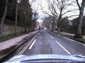
6

                                                            TABLE II
S UMMARY OF RECENT WORKS ON SUPERVISED PLACE RECOGNITION USING PRE - TRAINED FRAMEWORKS . A LL THE WORKS USE CAMERA - BASED DATA .
                                       BG = B ELIEF G ENERATION AND PM = P LACE MAPPING .

    Type          Ref                                Model                                          BG/PM                               Dataset

                  [21]    Feature Extraction: OxfordNet [97] and GoogLeNet [98];         L2 distance/Database        Holidays [101]; Oxford [102];
                          Descriptor: VLAD [99] + PCA [100]                                                          Paris [103]
 Holistic-based

                  [104]   Feature Extraction: CNN-VTL (VGG-F [105])                      Hamming distance/Database   Nordland [2]; CMU-CVG Visual Localization
                          Descriptor: Conv5 layer + Random selection (LDB [106])                                     [107]; Alderley [51];

                  [22]    Feature Extraction: AlexNet [108];                             Hamming KNN/Database        Nordland [2]; Gardens Point [22]; The Campus
                          Descriptor: Conv3 layer                                                                    Human vs. Robot; The St. Lucia [109]

                  [23]    Landmark Detection: Left and right image regions               Sequence Match/Database     Oxford Robotcar [102];
                          Feature Extraction: CNN Places365 [110]                                                    University Campus;
                          Descriptor: fc6 + normalization + concatenation
 Landmark-based

                  [111]   Landmark Detection: Edge Boxes                                 Cosine KNN/Database         Gardens Point [22]; Mapillary;
                          Feature Extraction: ALexNet                                                                Library Robot Indoor; Nordland [2];
                          Descriptor: Conv3 layer + Gaussian Random Projection [112]

                  [113]   Landmrk detection: BING [114]                                  L2- KNN/Database            Gardens Point [22]; Berlin A100, Berlin
                          Feature Extraction: AlexNet                                                                Halenseestrasse and Berlin Kudamm [111];
                          Descriptor: pool 5 layer + Gaussian Random Projection [112],                               Nordland [2]; St. Lucia [109];
                          [115] + normalization

                  [59]    Feature Extraction: Fast-Net (VGG) [116]                       Cosine distance/Database    Cityscapes [118];
                          Descriptor: conv3 + L2-normalization + Sparse Random Pro-                                  Virtual KITTI [119];
                          jection [117]                                                                              Freiburg;
 Region-based

                  [40]    Feature Extraction: VGG16 [120]                                Cross matching/ Database    Gardens Point [22]; Nordland [2]; Berlin A100,
                          Descriptor: Salient regions from different layers + Bag-of-                                Berlin Halenseestrasse and Berlin Kudamm
                          Words [121]                                                                                [111];

                  [122]   Feature Extraction: AlexNet365 [123]                           Cosine distance/Database    Mapillary; Gardens Point [22]; Nordland [2];
                          Descriptor: (Region-VLAD) salient regions + VLAD                                           Berlin A100, Berlin Halenseestrasse and Berlin
                                                                                                                     Kudamm [111];

compressed using a random selection approach for efficient                               effectiveness of place-centric semantic information in extreme
matching.                                                                                variations such as front versus rear view. In particular, this
   2) Landmark-based: Landmark-based approaches, contrary                                work crops the right and left regions of images, which has been
to the aforementioned methods, do not feed the entire image to                           demonstrated to possess useful information [59], for place
the network; instead, these approaches use, in a pre-processing                          description. The work highlights the importance of semantics-
stage, object proposal techniques to identify potential land-                            aware features from higher-order layers for viewpoint and con-
marks in the images, which are feed to the CNN. Contrary                                 dition invariance. Additionally, to improve robustness against
to holistic-based approaches, where all image features are                               appearance, a descriptor normalization approach is proposed.
transformed to descriptors, in landmark-based approaches,                                Descriptor normalization of the query and reference descrip-
only the features from the detected landmarks are converted to                           tors are computed independently since the image conditions
descriptors. Detection approaches used in these works include                            differ (i.e., day-time vs. night-time). While matching is com-
Edge Boxes, BING, or simple heuristics.                                                  puted using SeqSLAM [42].
   With the aim of addressing the extreme appearance and                                    3) Region-based: Region-based methods, similarly to
viewpoint variations problem in place recognition, Sünderhauf                           landmark-based approaches, rely on local features; however,
et al. [111] propose such a landmark detection approach. Land-                           instead of utilizing object proposal methods, the regions of
marks are detected using Edge Boxes [127] and are mapped                                 interest are identified on the CNN layers, detecting salient
into a feature space using the features from Alexnet’s [124]                             layer activations. Therefore, region-based methods feed the
conv3 layer. The descriptor is also compressed for efficiency                            entire image to the DL model and use, for the descriptors,
reasons, using a Gaussian Random Projection approach [112].                              only the salient activation in the CNN layers.
   A similar approach is proposed by Kong et al. [113].                                     Addressing the problem of viewpoint and appearance chang-
However, instead of detecting landmarks using Edge Boxes                                 ing in place recognition, Chen et al. [40] propose such a
[127] and extracting features from conv3 layer of Alexnet,                               region-based approach that extracts salient regions without
landmarks are detected using BING [114] and features are                                 relying on external landmark proposal techniques. Regions of
extracted from a pooling layer.                                                          interest are extracted from various CNN layers of a pre-trained
   A slightly different approach is proposed by Garg et al.                              VGG16 [120]. The approach extracts explicitly local features
[23], which resorting to Places365 [110], also highlights the                            from the early layers and semantic information from later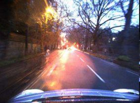
7

                                                    Positive Pair                Negative Pair                             Positive Pair Probe A            Negative Pair Probe A      Negative Pair Probe B

      Anchor              Negative       Positive                     Anchor                     Negative           Positive                       Anchor                       Negative                  Negative

       Feature             Feature        Feature                     Feature                     Feature            Feature                        Feature                      Feature                   Feature
      Extraction          Extraction     Extraction                  Extraction                  Extraction         Extraction                     Extraction                   Extraction                Extraction

    Descriptor          Descriptor     Descriptor                   Descriptor              Descriptor            Descriptor                 Descriptor                      Descriptor                Descriptor
     Creation            Creation       Creation                     Creation                Creation              Creation                   Creation                        Creation                  Creation

     Contrastive or margin loss                                 Triplet Loss                                                                           Quadruplet Loss

                   a)                                                   b)                                                                                           c)

Fig. 6. Block diagram of training strategies using a) contrastive-based and margin-based, b) triplet and c) quadruplet loss function.

layers. The extracted regions are encoded into a descriptor,                                            [25], quadruplet-based [49], and contrastive-based [13]. Figure
using a bag-of-words-based approach [121] which is matched                                              6 illustrates the various training strategies of the loss functions.
using a cross-matching approach.                                                                           The contrastive loss is used in siamese networks [13],
   Naseer et al. [59], on the other hand, learn the activation                                          [143], which have two branches with shared parameters. This
regions of interest resorting to segmentation. In this work,                                            function computes the similarity distance between the output
regions of interest represent stable image areas, which are                                             descriptors of the branches, forcing the netwroks to decrease
learned using Fast-Net [116]. Fast-Net is an up-convolutional                                           the distance between positive pairs (input data from the same
Network that provides near real-time image segmentation.                                                place) and increase the distance between negative pairs. The
Due to being too large for real-time matching, the features                                             function can be described as follow:
resulting from the learned segments are encoded into a lower
dimensionality using L2-normalization and Sparse Random                                                                 1      1
                                                                                                                     L = Y D2 + (1 −Y ) max(0, m − D)2                                                               (1)
Projection [117]. This approach, in particular, learns human-                                                           2      2
made structure due to being more stable for more extended                                               where D = ||Ra − Rx ||2 represents the Euclidean distance
periods.                                                                                                between the descriptor representation from the branch of the
   With the aim of reducing the memory and computational                                                anchor image (Ra ) and the descriptor representation from the
cost, Khaliq et al. [122] propose Region-VLAD. This ap-                                                 other branch (Rx ). While m represents a margin parameter, Y
proach leverages a lightweight place-centric CNN architecture                                           represents the label, where Y = 1 refers to a positive pair and
(AlexNet365 [123]) to extract regional features. These features                                         Y = 0 otherwise.
are encoded using a VLAD method, which is specially adapted                                                Similar to the former loss, the triplet loss also relies on
to gain computation-efficiency and environment invariance.                                              more than one branch during training. However, instead of
                                                                                                        computing the distance between positive or negative pairs at
B. End-to-End Frameworks                                                                                each iteration, the triplet loss function computes the distance
                                                                                                        between a positive and a negative pair at the same iteration,
   Conversely to pre-trained frameworks, end-to-end frame-                                              relying, thus, on three branches. As in the former loss function,
works resort to machine learning approaches that learn the                                              the objective is to train a network to keep positive pairs close
feature representation and obtain a descriptor directly from the                                        and negative pairs apart. The Triplet loss function can be
sensor data while training on a place recognition task. A key                                           formulated as follows:
aspect of end-to-end learning is concerned with the definition
of the training objective: i.e., what are the networks optimized                                                                  L = max(0, D2p − D2n + m)                                                          (2)
for, and how are they optimized. In place recognition, networks
are mostly optimized to generate unique descriptors that can                                            where D p refers to the distance between positive pairs (i.e.,
identify the same physical place regardless of the appearance                                           between anchor and positive sample) and Dn refers to the
or viewpoint. The achievement of such an objective is deter-                                            distance between the negative pair. This function is widely
mined by selecting, for the task in hands, an adequate network                                          used in place recognition, namely in frameworks that use input
, and adequate network training, which depends on the loss                                              data from the camera, 3d LiDARs, and RADARs, which adapt
function.                                                                                               the function to fit the training requirements. Loss functions that
   1) Loss functions: The loss function is in particular a                                              drive from the triplet loss include Lazy triplet [65], weighted
major concern in the training phase, since it represents the                                            triplet loss [96] and weakly supervised triplet ranking loss
matematical interpretation of the training objective, and thus                                          [24].
determining the successful convergence of the optimization                                                 The quadruplet is an extension of the triplet loss, introducing
process. In place recognition loss functions include triplet-                                           an additional constraint to push the negative pairs [145] from
based [24], [34], [50], [65], [81], [96], [137], margin-based                                           the positives pairs w.r.t different probe samples, while triplet
8

                                                                     TABLE III
            S UMMARY OF RECENT WORKS ON SUPERVISED END - TO - END PLACE RECOGNITION . BG = B ELIEF G ENERATION AND PM = P LACE MAPPING .

 Sensor           Ref                       Architecture                           Loss Function                 BG/PM                       Dataset

                  [24]    NetVLAD:                                       Triplet loss                       KNN /Database         Google Street View Time Ma-
                          VGG/AlexNet + NetVLAD layer                                                                             chine; Pitts250k [128];

                  [25]    2D CNN visual and 3D CNN structural feature    Margin-based loss [129]            KNN /Database         Oxford RobotCar [1];
                          extraction + Feature fusion network;

                  [96]     SPE-VLAD:                                     Weighted Triplet                   L2 /Database          Pittsburgh [128];
                          (VGG-16 network or ResNet18) + spatial pyra-                                                            TokyoTimeMachine [130];
                          mid structure + NetVLAD layer                                                                           Places365-Standard [110];
 Camera

                  [131]   Siamese-ResNet:                                L2-based loss [132]                L2 /Database          TUM [133];
                          ResNet in the siamese network

                  [50]    MobileNet [134]                                Triplet loss [135], [136]          Hamming        K-NN   Nordland [2];
                                                                                                            /Database             Gardens Point [22]

                  [137]   HybridNet [138]                                Triplet Loss                       Cosine /Database      Oxford RobotCar [6]; Nordland
                                                                                                                                  [2]; Gardens Point [22];

                  [49]    LPD-Net:                                       Lazy quadruplet loss               L2 /Database          Oxford Robotcar [1];
                          Adaptive feature extraction + a graph-based
                          neighborhood aggregation + NetVLAD layer

                  [65]    PointNetVLAD:                                  Lazy triplet and quadruplet loss   KNN /Database         Oxford RobotCar [1];
                          PointNet + NetVLAD layer
 3D LiDAR

                  [34]    OREOS:                                         Triplet loss [140]                 KNN /Database         NCLT [141];
                          CNN as in [120], [139]                                                                                  KITTI [142];

                  [13]    LocNet:                                        Contrastive loss function [143]    L2 KNN /Database      KITTI [142]
                          Siamese network                                                                                         inhouse dataset

                  [144]   Siamese network                                Contrastive loss [143]             L2 KNN /Database      KITTI [142]; inhouse dataset;

 RADAR            [81]    VGG-16 + NetVLAD layer                         Triplet loss                       KNN /Database         Oxford Radar RobotCar [6]

loss only pushes the negatives from the positives w.r.t from the                        state-of-art performance could be achieved with a simple loss
same probe. The additional constrain of the quadruplet loss                             function, only by having an adequate sampling strategy of the
reduces the intra-class variations and enlarges the inter-class                         input data during training. This function is used in [25] to train
variations. This function is formulated as follows:                                     a multi-modal network. The network is jointly trained based
                                                                                        on information extracted from images and structural data in the
            L = max(0, D2p − D2n + m1 ) + max(0, D2p − D2d + m2 )            (3)        format of voxel grids, which are generated from the images.
where D p and Dn represent the distance between the positive                               2) Camera-based Networks: A key contribution to super-
and negative pairs, respectively. The m1 and m2 represent                               vised end-to-end-based place recognition is the NetVLAD
margin parameters, while Rd corresponds to the additional con-                          layer [24]. Inspired by the Vector of Locally Aggregated
straint, representing the distance between negative pairs from                          Descriptors (VLAD) [146], Arandjelović et al. [24] propose
different probes. In [49], [65], the quadruplet loss function is                        NetVLAD as a ‘pluggable’ layer into any CNN architecture to
used to train networks for the task of place recognition using                          output a compact image descriptor. The network’s parameters
3D LiDAR data.                                                                          are learned using a weakly supervised triplet ranking loss
   The margin-based loss function is a simple extension to the                          function.
contrastive loss [129]. While the contrastive function enforces                            Yu et al. [96] also exploited VLAD descriptors for images,
the positive pairs to be as close as possible, the margin-based                         proposing a spatial pyramid-enhanced VLAD (SPE-VLAD)
function only encourages the positive pairs to be within a                              layer. The proposed layer leverages the spatial pyramid struc-
distance of each other.                                                                 ture of images to enhance place description, using for feature
                                                                                        extraction a VGG-16 [120] and a ResNet-18 [147], and as
                          L = max(0, α +Y (D − m))                           (4)
                                                                                        loss function the weighted T-loss. The network’s parameters
where Y ∈ 1, −1 represents the labels of Y = 1 when the pair is                         are learned under weakly supervised scenarios, using GPS tags
positive and Y = −1 otherwise. α is a variable that determines                          and the Euclidean distance between the image representations.
the boundary between positive and negative pairs. The margin-                              Qiu et al. [131] apply a siamese-based network to loop
based loss function was proposed in [129] to demonstrate that                           closure detection. Siamese networks are twin neural networks,
9
which share the same parameters and are particularly useful neighborhood aggregation module, aggregating both in the
when limited training data is available. Both sub-networks Feature Space and the Cartesian Space. Regarding the network
share the same parameters and mirror the update of the training, Uy et al. [65] showed that the lazy quadruplet loss
parameters. In this work, the sub-networks are replaced by function enables higher performance than the lazy triplet loss
ResNet to improve feature representation, and the network is function, motivating Liu et al. [49] to follow this approach.
trained, resorting to an L2-based loss function as in [132]. A different 3D-LiDAR-based place recognition approach is
Wu et al. [50] jointly addresses the place recognition proposed in [34]. Schaupp et al. propose OREOS, which is
problem from the efficiency and performance perspective, a triplet DL network-based architecture [140]. The OREOS
proposing to this end a deep supervised hashing approach approach receives as input 2D range images and outputs
with a similar hierarchy. Hashing is an encoding technique that orientation-and place-dependent descriptors. The 2D range
maps high dimensional data into a set of binary codes, having images are the result of the 3D point clouds projections
low computational requirements and high storage efficiency. onto an image representation. The network is trained using
The proposed framework comprises three modules: features an L2 distance-based triplet loss function to compute the
extraction based on MobileNet [134]; hash code learning, similarity between anchor-positive and anchor-negative. Place
obtained using the last fully connected layer of MobileNet; recognition is validated using a k-nearest neighbor framework
and loss function, which is based on the likelihood [135], for matching.
[136]. This work proposes a similar hierarchy method to Yin et al. [13] uses 3D point clouds to address the global
distinguish similar images. To this end, the distance of hashing localization problem, proposing a place recognition and metric
codes between a pair of images must increase as similar pose estimation approach. Place recognition is achieved using
images are more distinct and must remain the same between the siamese LocNets, which is a semi-handcrafted represen-
different images. These two conditions are essential to use tation learning method for LiDAR point clouds. As input,
deep supervised hashing in place recognition. LocNets receives a handcrafted rotational invariant represen-
Another efficiency improving technique for deep networks tation extracted from point clouds in a pre-processing step and
is network pruning. This technique aims to reduce the size outputs a low-dimensional fingerprint. The network follows a
of the network by removing unnecessary neurons or setting Siamese architecture and uses for learning Euclidean distance-
the weights to zero [148]. Hausler et al. [137] propose a based contrastive loss function [143]. For belief generation,
feature filtering approach, which removes feature maps at the an L2-based KNN approach is used. A similar LocNets-based
beginning of the network while using for matching late feature approach is proposed in [144].
maps to foster efficiency and performance simultaneously. 4) RADAR-based: Regarding RADAR-based place recog-
Feature maps to be removed are determined based on a Triplet nition, Saftescu et al. [95] also propose a NetVLAD-based
Loss calibration procedure. As a feature extraction framework, approach to map FMCW RADAR scans to a descriptor space.
the approach uses the HybridNet [138]. Features are extracted using a specially tailored CNN based on
Contrary to former single modality works, Oertel et al. cylindrical convolutions, anti-aliasing blurring, and azimuth-
[25] propose a place description approach that uses vision wise max-pooling to bolster the rotational invariance of polar
and structural information, both originated from camera data. radar images. Regarding training, the network uses a triplet
This approach jointly uses vision and depth data from a stereo loss function as proposed in [151].
camera in an end-to-end pipeline. The structural information
is first obtained utilizing the Direct Sparse Odometry (DSO)
V. U NSUPERVISED P LACE R ECOGNITION
framework [149] and then discretized into regular voxel grids
to serve as inputs along with the corresponding image. The The aforementioned supervised learning approaches achieve
pipeline has two parallel branches: one for vision and another excellent results in learning discriminative place models. How-
for the structural data, which use 2D and 3D convolutional ever, these methods have the inconvenience of requiring a vast
layers, respectively, for feature extraction. Both branches are amount of labeled data to perform well, as it is common in
learned jointly through a margin-based loss function. The supervised DL-based approaches. Contrary to supervised, un-
outputs of the branches are concatenated into a single vector, supervised learning does not require labeled data, an advantage
which is fed to a fusion network that outputs the descriptor. when annotated data are not available or scarce.
3) 3D LiDAR-based Network: Although NetVLAD was Place recognition works use unsupervised approaches such
originally used for images, it has also been used on 3D as Generative Adversarial Networks (GAN) for domain trans-
LiDAR data [49], [65]. Uy et al. [65] and Liu et al. [49] lation [152]. An example of such an approach is proposed
propose respectively PointNetVLAD and LPD-Net, which are by Latif et al. [152], which address the cross-season place
NetVLAD-based global descriptor learning approaches for recognition problem as a domain translation task. GANS are
3D LiDAR data. Both have compatible inputs and outputs, used to learn the relationship between two domains without
receiving as input raw point clouds and outputting a descriptor. requiring cross-domain image correspondences. The proposed
The difference relies on the feature extraction and feature architecture is presented as two coupled GANs. The generator
processing methods. PointNetVLAD [65] relies on PointNet integrated an encoder-decoder network, while the discrimi-
[150], a 3D object detection and segmentation approach, nator integrates an encoder network followed by two fully
for feature extraction. In contrast, LPD-Net relies on an connected layers. The output of the discriminator is used
adaptive local feature extraction module and a graph-based as a descriptor for place recognition. Authors show that the10
discriminator’s feature space is more informative than image On the other hand, Tang et al. [162] propose a self-
pixels translated to the target domain. supervised learning approach to disentangle place-rated fea-
Yin et al. [153] also proposes a GAN-based approach, tures from domain-related features. The backbone architecture
but for 3D LiDAR-based. LiDAR data are first mapped of the proposed approach is a modified autoencoder for
into dynamic octree maps, from which bird-view images are adversarial learning: i.e., two input encoder branches con-
extracted. These images are used in a GAN-based pipeline verging into one output decoder. The disentanglement of the
to learn stable and generalized place features. The network two feature domains is solved through adversarial learning,
trained using adversarial and conditional entropy strategies to which constrains the learning of domain specific features (i.e.,
produce a higher generalization ability and capture the unique features depending on the appearance); a task that is not
mapping between the original data space and the compressed guaranteed by the reconstruction loss of autoencoders. For
latent code space. adversarial learning, the proposed loss function is the least
Han et al.,(2020) [88] propose a Multispectral Domain square adversarial loss [163]; while for reconstruction, the loss
Invariant framework for the translation between unpaired RGB function is the L2 distance.
and thermal imagery. The proposed approach is based on Dubé et al. [77] propose SegMap, an data-driven learn-
CycleGAN [154], which relies, for training, on the single ing approach for the task of localization and mapping. The
scale structural similarity index (SSIM [155]) loss, triplet loss, approach uses as the main framework an autoencoder-like
adversarial loss, and two types of consistency losses (cyclic architecture to learn object segments of 3D point clouds.
loss [154] and pixel-wise loss). The proposed framework The framework is used for two tasks: (supervised) classifi-
is further validated on semantic segmentation and domain cation and (unsupervised) reconstruction. The work proposes
adaptation tasks. a customized learning technique to train the network, which
Contrary to the former works, which were mainly based on comprises, for classification, the softmax cross-entropy loss
GAN approaches, Merril and Huang [94] propose, for visual function in conjunction with the N-ways classification problem
loop closure, an autoencoder-based approach to handle the learning technique [164], and, for reconstruction, the binary
feature embedding. Instead of reconstructing original images, cross-entropy loss function [165]. The latent space, which
this unsupervised approach is specifically tailored to map is jointly learned on the two tasks, is used as a descriptor
images to a HOG descriptor space. The autoencoder network for segment retrieval. The proposed framework can be used
is trained, having as input a pre-processing stage, where two in global localization, 3D dense map reconstruction, and
classical geometric vision techniques are exploited: histogram semantic information extraction tasks.
of oriented gradients (HOG) [156], and the projective trans-
formation (homography) [157]. HOG enables the compression VII. OTHER F RAMEWORKS
of images while preserving salient features. On the other
hand, the projective transformation allows the relation of This section is dedicated to the frameworks that have more
images with differing viewpoints. The network has a minimal complex and entangled architectures: i.e., containing more
architecture, enabling fast and reliable close-loop detection in than one place recognition approach for the purpose of finding
real-time with no dimensionality reduction. the best loop candidates. Two main frameworks are high-
lighted: parallel and hierarchical. While parallel frameworks
have a very defined structure, hierarchical frameworks may
VI. S EMI - SUPERVISED P LACE R ECOGNITION assume very complex and entangled configurations, but both
In this work, Semi-supervised approaches refer to works frameworks have the end goal of representing more performant
that jointly rely on supervised and unsupervised methods. The place recognition methods.
combination of these two learning approaches is particularly
used for the cross-domain problem. However, rather than A. Parallel Frameworks
translating one domain to another, these learning techniques
are used to learn features that are independent of the domain Parallel frameworks refer to approaches that rely on multiple
appearance. A summary of recent works is presented in Table information streams, which are fused into one branch to gen-
V. erate place recognition decisions. These parallel architectures
To learn domain-invariant features for cross-domain visual fuse the various branches utilizing methods such as feature
place recognition, Wang et al. [160] propose an approach that concatenation [44], HMM [166] or multiplying normalized
combines weakly supervised learning with unsupervised learn- data across Gaussian-distributed clusters [167]. Approaches
ing. The proposed architecture has three primary modules: an such as proposed by Oertel et al. [25], where vision and struc-
attention module, an attention-aware VLAD module, and a tural data are fused in an end-to-end fashion, are considered to
domain adaptation module. The supervised branch is trained belong to the Section IV-B because features are jointly learned
with a triplet ranking loss function, while the unsupervised in an end-to-end pipeline. An example of parallel frameworks
branch resorts to a multi-kernel maximum mean discrepancy is illustrated in Fig. 7, and a summary of recent works is
(MK-MMD) loss function. presented in Table VI.
Relying on multiple information streams allows overcoming
1 https://www.mapillary.com individual sensory data limitations, which can be, for instance,
2 https://beeldbank.amsterdam.nl/beeldbank due to environment changing conditions. Zhang et al. [44]11
TABLE IV
S UMMARY OF RECENT WORKS USING UNSUPERVISED END - TO - END LEARNING TECHNIQUES FOR PLACE RECOGNITION .
Sensor Ref Architecture Loss Function Task Dataset
Camera [152] Architecture: Coupled GANs + encoder-decoder Minimization of the cyclic re- Domain translation for cross Norland [2];
network construction loss [158] domain place recognition
Camera [94] Pre-processing: HOG [156] and homography L2 loss function Unsupervised feature embed- Places [110]; KITTI [142];
[157] ding for visual loop closure Alderley [42]; Norland [2]; Gar-
Architecture: small Autoencoder dens Point [22];
RGB + [88] Multispectral Domain Invariant model SSIM [155] + triplet + adversar- Unsupervised multispectral im- KAIST [159];
Thermal Architecture: CycleGAN [154] ial + cyclic loss [154] + pixel- agery translation task
wise loss
3D [152] Pre-processing: Mapping LiDAR to dynamic Adversarial learning and condi- Unsupervised Feature learning KITTI [142];
LiDAR octree maps to bird-view images tional entropy for a 3D LiDAR-based place NCTL [141];
Architecture: GAN + encoder-decoder network recognition task
TABLE V
R ECENT WORKS THAT COMBINE SUPERVISED AND UNSUPERVISED LEARNING IN PLACE RECOGNITION SYSTEMS .
Sensor Ref Architecture Loss Function Task Dataset
[160] Feature extraction: AlexNet cropped(conv5) Supervised: triplet ranking; Single and cross-domain VPR Mapillary 1
Supervised: VLAD + attention module Unsupervised: MK-MMD [161] Beeldbank 2
Camera
Unsupervised: domain adaptation
[162] Supervised: adversarial learning Adversarial Learning: Least Disentanglement of place and Nordland [2];
Unsupervised: autoencoder square [163]; appearance features in a cross Alderley [42];
Reconstruction: L2 distance domain VPR
3D [77] Supervised: latent space + classification net- Classification: softmax cross Global localization, 3D dense KITTI odometry [142];
LiDAR work entropy [164] map reconstruction, and seman-
Unsupervised: Autoencoder-like network Reconstruction: binary cross tic information extraction
entropy [165]
address the loop closure detection problem under strong per- methods that rather are computer efficient than accurate. These
ceptual aliasing and appearance variations, proposing Robust top candidates are feed to the fine tier, which can use more
Multimodal Sequence-based (ROMS). ROMS concatenates computer demanding methods to find the best loop candidate.
LDB features [168], GIST features [169], CNN-based deep The coarse-to-fine architecture, while being the most common,
features [170] and ORB local features [171] in a single vector. is not the only. Other architectures exist, for example Fig.
A similar (parallel) architecture is proposed by Hausler et 7 illustrates a framework proposed in [176] and Table VII
al. [166], where an approach, called Multi-Process Fusion, presents a summary of recent works.
fuses four image processing methods: SAD with patch nor- Hausler and Milford [176] show that parallel fusion strate-
malization [42], [172]; HOG [173], [174]; multiple spatial gies have inferior performance compared with hierarchical
regions of CNN features [138], [175]; and spatial coordinates approaches and therefore propose Hierarchical Multi-Process
of maximum CNN activations [41]. However, instead of fusing Fusion, which has a three-tier hierarchy. In the first tier, top
all features to generate one descriptor as proposed in [44], candidates are retrieved from the database based on HybridNet
here, each feature stream is matched separately using cosine [138] and Gist [177] features. In the second tier, from the
distance, and only the resulting similarity values are fused top candidates of the previous tier, a more narrow selection is
using the Hidden Markov model. performed based on KAZE [178] and Only Look Once (OLO)
[123] features. Finally, the best loop candidate is obtained
B. Hierarchical Frameworks in the third tier using NetVLAD [24] and HOG [18]. An
In this work, hierarchical frameworks refer to place recog- illustration of this framework is presented in Fig. 7.
nition approaches that, similarly to parallel frameworks, rely Garg et al. [41] also follow a similar framework, proposing
on multiple methods; however, instead of having as main a hierarchical place recognition approach, called X-Lost. In
framework a parallel architecture, the architecture is formed the coarse tier, top candidates are found by matching the
by various stacked tiers. The hierarchical architectures find the Local Semantic Tensor (LoST) descriptor, which comprises
best loop candidate by filter candidates progressively in each feature maps from the RefineNet [179] (a dense segmentation
tier. An example of such a framework is the coarse-to-fine network) and semantic label scores of the road, building, and
architecture, which has a coarse and a fine tier. The coarse vegetation classes. The best match is found in the fine tier by
tier is mostly dedicated to retrieving top candidates utilizing verifying the spatial layout of semantically salient keypointYou can also read