PLANNING JUSTIFICATION REPORT - City of Belleville
←
→
Page content transcription
If your browser does not render page correctly, please read the page content below
PLANNING JUSTIFICATION REPORT

                                Draft Plan of Subdivision &
                                  Rezoning Applications
                                             for
                                     Hanley Park North
                                Part of Lot 14, Concession 1
                                      City of Belleville

                                        Prepared for:
                                Hanley Park Developments Inc.

                                            By
                                Macaulay Shiomi Howson Ltd

                                        January 2021

land use planning consultants                                   www.mshplan.ca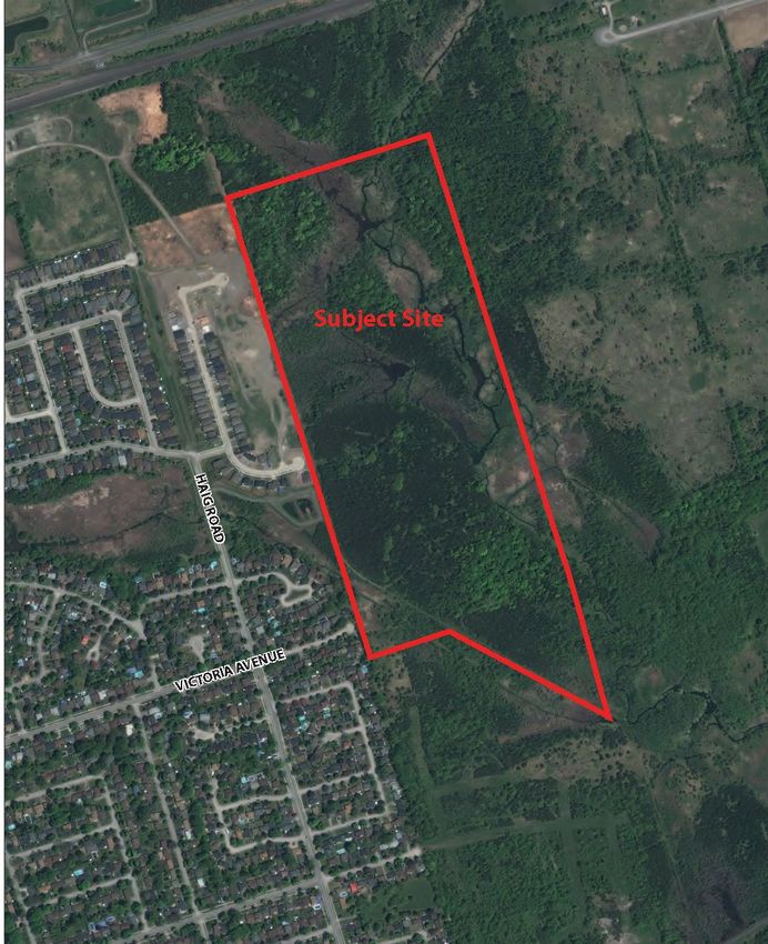
Hanley Park North Development
Planning Rationale Report

Table of Contents
1     Introduction ................................................................................................................. 1
    1.1     Background........................................................................................................... 1
    1.2     Context ................................................................................................................. 1
    1.3     Proposed Development ....................................................................................... 3
2     Provincial Policy Statement ......................................................................................... 5
3     Belleville Official Plan .................................................................................................. 8
4     Zoning By-law ............................................................................................................ 14
5     Supporting Studies..................................................................................................... 19
    5.1     Environmental Impact Study .............................................................................. 19
    5.2     Flow Monitoring Brief ........................................................................................ 20
    5.3     Stormwater Brief ................................................................................................ 20
    5.4     Servicing Brief ..................................................................................................... 21
    5.5     Stage 1 & 2 Archaeological Assessment............................................................. 21
    5.6     Noise and Vibration Impact Study ..................................................................... 21
    5.7     Traffic Impact Study ........................................................................................... 22
    5.8     Landscape /Development Concept .................................................................... 22
6     Summary and Conclusions ........................................................................................ 24

Macaulay Shiomi Howson Ltd
Hanley Park North
Planning Rationale Report                                                             11

1          Introduction
1.1        Background
The purpose of this report is to provide a planning rationale in support of rezoning and
subdivision applications on behalf of Hanley Park Development Inc. for lands referred to
as Hanley Park North, which is a proposed residential development on the east side of
Belleville. The subject site is located in Lot 14 Concession 1 north of Bell Creek formerly
in the Township of Thurlow. It contains 34.3 ha (84.8 ac) and is contains trees, creeks and
wetlands.

1.2        Context
Hanley Park North is located east of Haig Road and north of Victoria Avenue with
proposed access from Tessa Boulevard and Spruce Gardens. The lands to the west of the
subject site are currently developed with single detached and townhouse lots as well as
a stormwater management pond and are referred to as the Mercedes Meadows
development.

The lands immediately to the south of the subject site, which is referred to as Hanley Park
Phase 1, are draft plan approved and zoned for single detached, semi-detached and
townhouse dwellings as well as park, open space and stormwater management blocks
but development of the lands has not commenced yet.

The lands to the north of the subject site are currently undeveloped and the lands to the
east are within the rural area and appear to be vacant.

An air photo of the existing context is shown on Figure 1.

Macaulay Shiomi Howson Ltd
Hanley Park North
Planning Rationale Report    22

Figure 1 Context Air Photo

Macaulay Shiomi Howson Ltd

Hanley Park North
Planning Rationale Report                                                            33

1.3         Proposed Development
The proposed Hanley Park North development will consist of 156 residential lots and
includes:

    •   60 single detached lots with 15 m (50 ft) frontages
    •   39 single detached lots with 9.75 (32 ft) m frontages
    •   57 townhouse lots with 6.0 m (20 ft) frontages
    •   3 park blocks containing 0.542 ha (1.34 ac)
    •   1 walkway /emergency access block which is 8 m (26 ft) wide
    •   1 walkway block which is 3 m (10 ft) wide
    •   Stormwater management facility block containing 0.518 ha (1.28 ac)
    •   Wetland, buffer and open spaces blocks containing 23.9 ha (59.06 ac)
    •   1 block of future development containing 0.634 ha (1.57 ac)

The proposed draft plan of subdivision is shown on Figure 2.

The parks and walkway blocks are intended to facilitate pedestrian connections that
recognize existing informal paths and provide new pedestrian walkways along the
western edge of development. A low impact wood chip path will be provided within Block
C and within the edge of the wetland buffers along the west side of the development as
shown on the development concept plan. Lands within the wetland will be dedicated to
the City or Conservation Authority who may explore the opportunity to create further
connections to the development to the south (Hanley Park Phase 1) which is also expected
to have walkways through the park and open space areas. As that would require crossing
the wetland, it has not been proposed by the owner.

Park Blocks A and B also provide the opportunity for tot lots or more passive recreational
opportunities.

The buffers that are proposed around the wetland are 30 m wide except for adjacent to
the stormwater management facility where they are proposed to be 25 m wide but will
be landscaped with natural vegetation. Approximately 70% of the total land area will be
protected from development and retained in a natural state.

Macaulay Shiomi Howson Ltd
Hanley Park North
Planning Rationale Report 44
Figure 2 Draft Plan of Subdivision
Macaulay Shiomi Howson LtdHanley Park North
Planning Rationale Report 55
2 Provincial Policy Statement
The Provincial Policy Statement (PPS) 2020 provides policy direction on matters of
provincial interest related land use planning and all decisions made under the Planning
Act shall be consistent with the PPS. The following analysis addresses how the proposed
development is consistent with the PPS:
1.0 Building Strong Healthy Communities
1.1 Managing and Directing Land Use to Achieve Efficient and Resilient Development and
Land Use Patterns
The proposed subdivision is located within the Settlement Area and Urban Serviced
Area of Belleville and represents a logical extension of the existing development area.
It provides for a mix of housing types within the community thereby increasing the
range of options, which improves the opportunity for housing that is more affordable.
It provides cost effective development patterns and efficiently uses land and
resources by extending services within a residential area to create a compact form
and contribute to a healthy, liveable and safe community. It supports active
transportation by providing sidewalks and trails for pedestrian connections.
1.2 Coordination
The Official Plan ensures a coordinated approach to the development and this
development assists in addressing housing projections and housing needs.
A noise study has been prepared to ensure that land use compatibility can be achieved
between the proposed sensitive residential uses and the railway lines to the north.
1.4 Housing
The subdivision provides for a variety of lot sizes to facilitate an appropriate range of
housing types and densities to meet projected requirements of current and future
residents with an appropriate level of infrastructure and public service facilities that
support the residents. The proposed development will assist in maintaining an ability
to accommodate residential growth for 15 years as well as a three-year supply of land
zoned to facilitate residential intensification and land in draft approved plans.
1.5 Public Spaces, Recreation, Parks, Trails and Open Space
There is a substantial amount of open space that provides passive open space
opportunities. The existing informal trail through Block C and within the wetland
buffer on along the western edge of the development is proposed to be developed
with a wood chip trail. The public park blocks provide small scale recreational
Macaulay Shiomi Howson LtdHanley Park North
Planning Rationale Report 66
opportunities such as tot lots. The subdivision will promote healthy, active
communities by providing sidewalks and walkways to meet the needs of pedestrians
for active transportation, and parks and open space for active living and social
interaction.
1.6 Infrastructure and Public Service Facilities
This development will be on full municipal services and will optimize use of existing
municipal sewer and water services. A Municipal Servicing Capacity Report and a
Stormwater Management Report have been prepared by Ainley Group which
demonstrates that sufficient capacity exists to provide for the development and that
the stormwater can be appropriately addressed through the proposed stormwater
management facility. The subdivision layout and density will provide for the safe
movement of people, the roads are sufficient to meet projected needs and the
development will support current and future use of transit and active transportation.
This proposed development will make efficient use of existing infrastructure.
1.7 Long Term Economic Prosperity
The proposed development helps with long term economic prosperity by optimizing
use of land, infrastructure and public service facilities, providing residential uses that
respond to market-based needs and provide a range of housing options.
1.8 Energy, Air Quality and Climate Change
The proposed development promotes active transportation, creates transit
supportive densities, provides for tree plantings and for homes that include energy
and water efficiency features.
2.0 Wise Use and Management of Resources
2.1 Natural Heritage
An Environmental Impact Study has been prepared for the subject site by Michalski
Nielson Associates Ltd. The report addresses development on the subject site and
within 120 m of the Bell Creek Provincially Significant Wetland (PSW). No
development will occur within the PSW and the report indicates that the proposed
retention of the wetland and the associated buffers as well as the recommended
mitigation measures is sufficient to protect its ecological functions. There will be no
negative impacts on the flora and fauna of the PSW and its contiguous upland
woodlands. More details are provided in section 5.1 of this report. The development
therefore protects the wetland for the long term and provides connectivity and
linkages between the natural heritage features on the subject site and adjacent
properties to support a natural heritage system.
Macaulay Shiomi Howson LtdHanley Park North
Planning Rationale Report 77
2.2 Water
Water quality and quantity are addressed in the Stormwater Report prepared by
Ainley and described in section 5.4 of this report. Water quality controls will be
addressed through the use of stormwater management techniques and the creation
of a stormwater management pond. Water quantity controls do not need to be
provided due to the proximity of Bell Creek.
2.6 Cultural Heritage and Archaeology
A Stage 1 and 2 Archaeological Assessment has been undertaken by Abacus
Archaeological Services which is described in more detail in section 5.5 of this report.
No archaeological features or resources were recovered during the Stage 2
excavation and the report concluded that there were no areas of archaeological
significance on the subject site. It was therefore recommended that no further
archaeological assessment was required. No cultural heritage sites or landscapes
have been identified on the subject site.
3.0 Protecting Public Health and Safety
3.1 Natural Hazard policies
The proposed development will be located outside of the 100 year floodline of the
Bell Creek and as a result, will not be located within hazard lands.
Summary and Conclusions
In summary, the proposed development of the subject site will provide a range of housing
types that meets future needs and makes efficient use of existing infrastructure and
public services. It will support active transportation and transit and the existing road
network is able to accommodate the development with no upgrades required. It will
provide extensive open space areas, and appropriately address water resources through
stormwater management facilities. It will protect natural heritage features as no
development will occur within the provincially significant wetland and its buffer, and it
will avoid natural hazards as development will occur outside of the floodplain. Noise
attenuation will be provided to ensure that the development is compatible with the
railway to the north. As a result, the proposed development is consistent with the PPS.
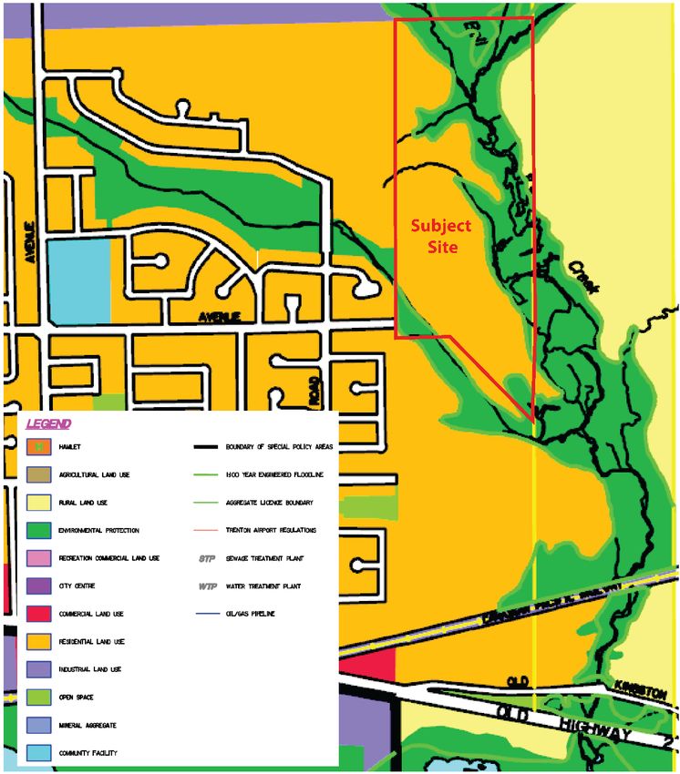
Macaulay Shiomi Howson LtdHanley Park North Planning Rationale Report 88 3 Belleville Official Plan The subject site is currently designated Residential, Environmental Protection with a small area of Rural in the northeast corner in Official Plan (OP) as shown on Figure 3. The lands designated Rural are not proposed for development at this time. The land designated Residential is also located within the Urban Serviced Area. Figure 3 Existing Official Plan designations – Excerpt of Schedule B from City of Belleville Official Plan Macaulay Shiomi Howson Ltd
Hanley Park North
Planning Rationale Report                                                             99

Residential

The Residential designation permits low, medium and high densities with built forms that
range from single detached dwellings to a variety of attached and multiple dwellings and
the proposed single detached dwellings and townhouses (row dwellings) are therefore
permitted.

The densities that are permitted in the OP are:
  i) Low density residential uses which would normally include single detached and
      attached two-unit dwellings, developed up to 18 units per hectare gross residential
      density or 25 units per hectare net residential density.
  ii) Medium density residential uses which would normally include various types of
      attached, multiple or cluster housing projects such as row dwellings and small low-
      profile apartment complexes, developed up to 60 units per hectare net residential
      density.

The policies state that ideally all neighbourhoods should contain a mixture of dwelling
types at different densities. It also supports the development of all forms of housing in
all forms of tenure.

In determining the neighbourhood densities, consideration should be given to:
    • the capacity of servicing systems to handle the traffic, water and sewage flows, and
       other services;
    • the capacity of schools, parks, and other soft services in the area to service the
       neighbourhood; and
    • the availability of or the ability to provide transit services.

The proposed single detached lots fall within the density range for low density residential
and the townhouses fall within the medium density range. The density of the
development as defined by the Official Plan is shown below.

                               Units                  Area                Units/Ha
 Gross Density                 156                   11.259                 13.9
 Single Detached Net            99                   5.402                  18.3
 Density
 Townhouse Net                   57                  1.581                   36.1
 Density

Macaulay Shiomi Howson Ltd
Hanley Park North
Planning Rationale Report 10
10
The OP policies state that the preferred locations for medium and high density residential
development should be guided by the following principles:
• The lands should have direct frontage on or immediate access to collector roads.
• The main access routes should not be through substantial areas of low density
residential development.
• Medium density residential development should be directed to areas which are
adequately serviced with open space and other required community facilities and
services, all of which should be of sufficient size to meet the needs of the residents
of the housing development.
• A preferred location would be in close proximity to or adjacent to non-residential
land uses which service the residential area (neighbourhood commercial uses,
schools, parks, churches).
• Medium density residential development is a preferred housing form immediately
abutting a non-residential land use in another land use category, or along very
high traffic corridors.
In this case, the subject site is in close proximity to Haig Road which is a collector road so
traffic will not have to travel through large areas of low density residential and there are
already townhouses within the neighbourhood on Spruce Gardens. The proposed
townhouses will be immediately abutting parkland (a non-residential land use) and will
have access to extensive open space areas. They will also be located within good
proximity to schools, parks, places of worship and the YMCA which are within
approximately 1.6 km. There is regular bus service along Haig Road through the
neighbourhood which connects the area to Bayview Mall and the downtown. Servicing
and flow monitoring reports have been prepared for these applications that indicate that
there is servicing capacity available to accommodate the development.
As a result, proposed subdivision and rezoning will contribute to a range of housing types
and sizes within the community and the proposed townhouses address the intent of the
OP policies for the location of medium density residential uses.
Environmental Protection
The policies state that lands within the Environmental Protection designation “require
special care and regulation due to their inherent natural or physical characteristics” due
to be hazard lands or containing natural heritage features. On the subject site, the
Environmental Protection designation applies to lands that are wetlands and within the
floodplain.
The OP policies state that no new development will be permitted within provincially
significant wetlands and that development may be permitted within 120 m where it has
Macaulay Shiomi Howson LtdHanley Park North
Planning Rationale Report 11
11
been demonstrated through an Environmental Impact Study (EIS) that there would be no
adverse impact on the natural area or ecological functions. As noted above, an
Environmental Impact Study has been prepared which assesses the impact of the
proposed development on the wetland. It concludes that on the subject site, a 30 m
buffer surrounding the residential development and a 25 m buffer around the stormwater
management pond that is supplemented with natural plantings is sufficient to protect its
ecological functions. A greater description of the findings in the EIS is provided in section
5.1 below. The EIS concludes that there will be no negative impacts on the flora and
fauna of the PSW and its contiguous upland woodlands.
There is an existing informal trail along the western edge of the subject site that follows
the hydro corridor and that trail will be incorporated into the open space and park system
that is proposed. It will be partly located within the 30 m wetland buffer in close proximity
to the rear of the lots.
As a result, the proposed development meets the requirements of the Environmental
Protection policies.
Servicing
The OP does not permit development unless there is adequate servicing available and as
discussed in further detail in section 5.3 below, a flow monitoring test was undertaken to
confirm that there is adequate capacity in the sanitary sewer system to accommodate the
proposed development. A servicing report, as discussed in further detail in section 5.2
below, indicates that services can be extended from the Mercedes Meadows subdivision
to the west and there is sufficient capacity within the pipes to accommodate the
development.
Policies also state that adequate consideration must be given to stormwater management
prior to permitting development to proceed and preliminary watermain design brief as
discussed in further detail in section 5.4 below has also been prepared. It states that the
proposed stormwater management facility will provide appropriate water quantity and
quality controls.
Transportation
Policies indicate that all development should have frontage on and access to a public road
and that direct access to municipal roads will only be permitted in locations that can
accommodate traffic in a safe manner. All of the proposed lots will have access to local
roads with good sight lines that can safely accommodate them. There are two access
roads into the subdivision. One is the extension of Spruce Gardens and the other is the
extension of Tessa Boulevard. Give the number of units that are proposed on the Tessa
Macaulay Shiomi Howson LtdHanley Park North
Planning Rationale Report 12
12
Blvd extension, a second access point will be developed for emergency access purposes.
Although it appears that Victoria Avenue was originally intended to be extended further
east (given the lack of cul de sac at the end of it), it is not proposed to provide a second
access into the subdivision by extending Victoria Avenue due to the existence of wetlands
at the end of the existing road. As a result, an emergency access is proposed through a
walkway / emergency access that connects to the Mercedes Meadows stormwater
management pond access road located immediately west of the subdivision. The
stormwater pond access road connects to directly to Haig Road.
Figure 4 Official Plan Transportation designations – Excerpt of Schedule C from City of
Belleville Official Plan
Macaulay Shiomi Howson LtdHanley Park North
Planning Rationale Report 13
13
As discussed in greater detail in section 5.7 below, a Traffic Impact Study has been
prepared which indicates that there is sufficient capacity on the existing roads to
accommodate the forecast traffic.
The OP policies state that recreational trails connecting various parts of the City are
considered an integral part of the City’s transportation system and provision has been
made for a trail open space along the western edge of the subject site. Sidewalks will be
provided on one side of all public roads and along the walkways linking to the trail as
demonstrated in section 5.8 below, in order to provide a safe pedestrian realm and
encourage active transportation.
The policies state that parking is an integral component of the transportation system.
Adequate parking will be provided in the subdivision through garages and driveways on
individual lots.
Summary and Conclusions
The subject site is currently designated Residential, Environmental Protection and Rural
in the Official Plan. The lands designated Rural and Environmental Protection are not
proposed for development. The Residential component of the subject site is also located
within the Urban Serviced Area.
The proposed development will create a range of densities and housing types to provide
a variety of housing options in an attractive setting. The proposed townhouses meet the
intent of the OP policies for the location of medium density residential development.
There is adequate water and waste water servicing available and stormwater quantity
and quality will be appropriately addressed through the development of a pond. There is
adequate road access to accommodate the development and the roads have the capacity
to accommodate the proposal.
The lands designated Environmental Protection will be protected and appropriately
buffered. The recommended mitigation measures will be implemented to ensure that
there will be no negative impact on the vegetation and fauna with the wetlands.
As a result, the proposed subdivision and rezoning conform to the Official Plan policies.
Macaulay Shiomi Howson LtdHanley Park North
Planning Rationale Report 14
14
4 Zoning By-law
The current zoning on the subject site is Residential Holding zone (RH-1) and
Environmental Control (E). A zoning by-law amendment application has been submitted
rezone the property to permit the lots in the draft plan of subdivision and to provide site
specific zone provisions.
Figure 5 Existing Zoning - Excerpt of Zoning By-law
Macaulay Shiomi Howson LtdHanley Park North
Planning Rationale Report 15
15
The following chart summarizes the proposed changes to the standard zoning provisions
that are requested. For greater detail, please see the draft Zoning By-law that is provided
with the application.
Lot Lot Area Front Rear Interior Side Exterior Lot Landscape
Frontage (Min) Yard Yard Yard Width Side Coverage Area
(Min) Depth Depth (Min) Yard All Bldgs (Min)
(Min) (Min) Width (Max)
(Min)
R4 - 59 9.75 m 310 sq 6.0 m 7.5 m 1.2 m except 2.4 m 45% 30%
Single m where a lot
Detached frontage is
Dwelling less than 11.0
m and then it
shall be 1.2 m
on one side &
0.6 m on
other side,
The 0.6 m
setback shall
be beside a
1.2 m setback
on the
adjacent
property
R4-60 25.0 m 400 sq 6.0 m 3.0 m 6.0 m on one 2.4 m 45% 30%
Single m; side & 1.2 m
Detached on the other
Dwelling side.
R5-45 6.0 m 195 sq 6.0 m 7.5 m 1.2 m, 2.4 m 45% 30%
Horizontal m 0 m where
Multiple attached
Attached
Dwelling
The land proposed to be zoned R4-59 will be developed with single detached lots. With
the exception of the proposed R4-60 zone which will only apply to one lot, one site specific
zone has been proposed for all of the single detached lots within the subdivision even
though there are two lot sizes proposed (9.75 m and 15.0 m). This will allow for flexibility
so that minor modifications may be made the draft plan of subdivision to respond to
Macaulay Shiomi Howson LtdHanley Park North
Planning Rationale Report 16
16
market demands without requiring a rezoning (while recognizing that a red-line approval
will be required for changes to the draft of subdivision). This approach to zoning is
consistent with the approach that was applied to other developments in the City including
the adjacent Mercedes Meadows subdivision.
The proposed changes to the R4 zone through the proposed site-specific zoning
provisions reflect a more contemporary approach while maintaining compatibility with
development in the area. The smaller 9.75 m lot frontage and corresponding 310 sq m
lot area allows for housing that is a more affordable to first time buyers or those wishing
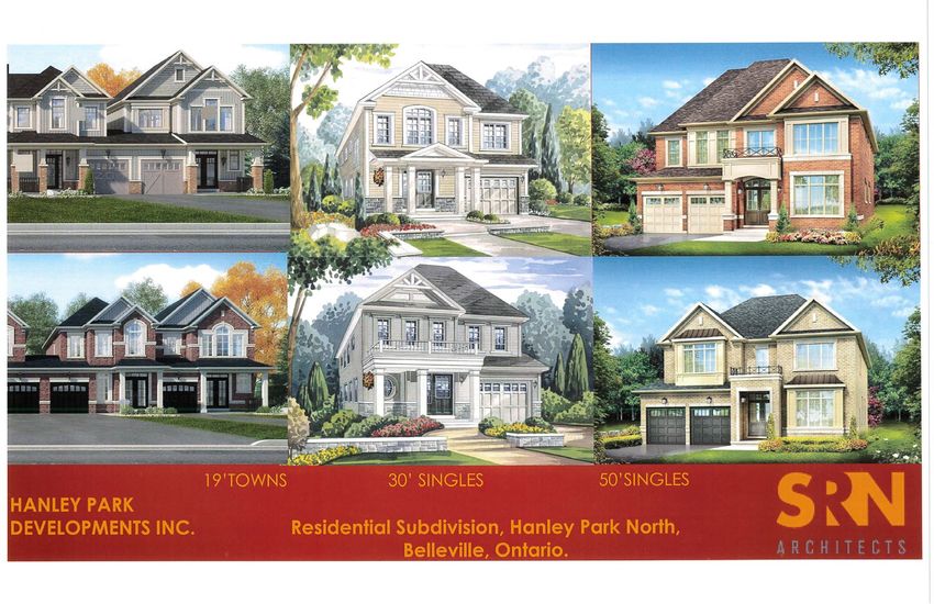
to downsize. As demonstrated in the elevation drawings in section 5.8 below, these lot
sizes can be developed with an attractive frontage that allows for a single car garage. The
proposed increase in the front yard depth to 6.0 m will ensure there is room for a car to
be parked in front of the garage and there is no proposed change to the rear yard setback
of 7.5 m.
The proposed interior side yard setback is 1.2 m except where a lot frontage is less than
11.0 m and then it is proposed to be 1.2 m on one side & 0.6 m on other side with the 0.6
m setback being beside a 1.2 m setback on the adjacent property. This will ensure there
is 2.1 m between houses and allow windows on one side of the house, adequate light
between the houses and suitable access to the rear yards. These side yard zoning
provisions for 1.2 m on one side & 0.6 m on other side with the 0.6 m setback being beside
a 1.2 m setback on the adjacent property were approved in the Riverstone subdivision for
lots with 11.0 m frontages and heights of 11.0 m. In this case, no change is proposed to
the current maximum height of 10.6 m. The 1.2 m side yard setback were approved in
the adjacent Mercedes Meadows and Hanley Park Phase 1 subdivisions so the proposed
interior side yard setbacks will compatible with the neighbourhood.
The provision for an outside side yard requirement in the R4 zone is proposed to be a
minimum width of 2.4 m and it is sufficient to ensure adequate sight lines at intersections.
The proposed lot coverage has been increased to 40% for lots greater than 11.0 m and
45% for lots with frontage of 11.0 m or less. There have been a number of examples in
Belleville where lot coverage has been increased to 40%, including Mercedes Meadows
and in the Riverstone subdivision, the lot coverage was increased to 45%. Even though
the lot coverage is increased for lots with less than 11.0 m frontage, the smaller lot size
will mean that the overall size of house will be similar to other houses in the
neighbourhood and the increased coverage will also facilitate the development of
bungalows for those with accessibility issues. The introduction of a minimum amount of
landscaped open space will also help to ensure that there will continue to be an
appropriate amount of green space on each lot. As demonstrated in the illustrations in
Macaulay Shiomi Howson LtdHanley Park North
Planning Rationale Report 17
17
section 5.8 below, the resulting house form presents an attractive design that does not
appear overwhelming or out of character with the neighbourhood.
The R4-60 is a site-specific zone to address one lot which has an atypical configuration
but which given its size and location is sufficient to provide for an attractive and functional
residential lot. The minimum lot frontage has been increased to 25 m. The lot is beside a
park on one side and backs onto wetland buffer and therefore will not have any rear
neighbours. As result, a 3 m rear yard setback will not infringe an any neighbour’s privacy.
A larger 6 m side yard on one side as well as a 6 m front yard setback for this wider than
average lot will allow for adequate open space and the side yard can effectively function
as the location for leisure activities.
The lands proposed to be zoned for R5-45 will be developed with freehold townhouses.
The lot frontage is proposed to be 6.0 m. This is similar to the lot frontages approved in
Hanley Park Phase 1 and are wide enough to allow for a single car garage and attractive
and functional front entry area on the ground floor. As demonstrated on the landscape
plan, it is also possible to achieve a good coverage of street trees in the boulevard.
The front yard setback is proposed to be reduced to from 7.5 m 6.0 m. This will allow
sufficient room for a car to park on the driveway and will provide for a consistent front
yard setback with the other lots within the subdivision.
The proposed interior side yard setback is 1.2 m and the proposed outside side yard
setback is 2.4 m which is again consistent with the other lots in the subdivision and which
will allow for adequate access to the rear yards, adequate sunlight and the ability to
provide for side wall windows.
The lot coverage has been increased to 50% and the landscape area correspondingly
reduced to 30%. This is lower than the lot coverage permitted for freehold townhouses
within Hanley Park Phase 1 which was 58% and a height of 12 m or 3 storeys. No increase
in height has been proposed to again provide consistency with the other lots within the
proposed subdivision and the adjacent Mercedes Meadows subdivision.
The proposed residential zoning will allow for appropriate standards of built form and
allow for attractive and functional development that is compatible with the character of
the neighbourhood.
The lands proposed to be zoned Open Space 1 will dedicated to the City for parks,
walkways and the stormwater management facility. As demonstrated in section 5.8
below, walkways will be developed along some of these lands and there is an opportunity
Macaulay Shiomi Howson LtdHanley Park North
Planning Rationale Report 18
18
for tot lots to be created at the entrance to the subdivision from Tessa Blvd and off of
Spruce Gardens. No site-specific changes are proposed to the O1 zone.
The lands proposed to be zoned Environmental Control represent the lands that will not
be developed and will be retained in their natural state for conservation purposes.
Macaulay Shiomi Howson LtdHanley Park North
Planning Rationale Report 19
19
5 Supporting Studies
5.1 Environmental Impact Study
An Environmental Impact Study (EIS) has been undertaken for the subject site by
Michalski Nielsen Associates Ltd and Cunningham Environmental Associates. The work
that has been carried out includes:
• reviewing existing site conditions,
• defining the limits of the Provincially Significant Bell Creek Swamp Wetland
Complex which exists on the property,
• summarizing the relevant environmental policies and regulations,
• evaluating the ecological significance of the natural heritage features,
• assessing the constraints to development,
• presenting mitigation measures, and
• providing recommendations and potential ecological constraints taking into
consideration the proposed development.
The subject site contains Provincially Significant Bell Creek Swamp Wetland Complex
(PSW) and the boundary of the PSW was confirmed with staff of Quinte Conservation in
attendance on two dates (i.e., July 25, 2008 and September 13, 2017). No development
is proposed within the PSW and a 30 m buffer width is proposed between the residential
lots and the boundary of the PSW, with a 25 m buffer width proposed between the
boundary of the PSW and the stormwater management facility. Both of those buffer
widths were discussed with Conservation Authority staff. The buffer areas will be
maintained in a natural state except for a possible passive recreational trail on the edge
of part of the buffer area.
Five woodland types were identified and mapped on the subject site, all of which are
common in the area and are not rare or significant on either a national or provincial level.
None of the individual plant species on the tablelands are considered Threatened or
Endangered on a federal or provincial level and there were no provincially or regionally
significant floral species observed in the field investigations.
The report makes the following recommendations:
• Siltation fencing and heavy-duty construction fencing be required around the
buffer during construction;
• A 1.5 m chain link fence be built around the edge of the lots where they interface
with the buffer to ensure no encroachment;
Macaulay Shiomi Howson LtdHanley Park North
Planning Rationale Report 20
20
• A Stewardship /Homeowner’s Manual be prepared and distributed to the
purchasers to educate them about the wetland and how to avoid potential
impacts on it;
• A low impact walkway be created along the edge of the buffer to reduce incursions
into the wetlands;
5.2 Flow Monitoring Brief
A flow monitoring program of the City’s sanitary sewers downstream of the proposed
development was undertaken by Ainley , in order to determine actual flow usage and
assess the available capacity for the proposed development. The analysis included
anticipated development within the sewer system in addition to the existing flows and
then added in the proposed development.
The analysis shows that even with the addition of the anticipated flows from the Hanley
Park North development, there should still be adequate capacity in the existing sewers,
as the original design flows for the sewers far exceed the value of Observed Flows +
Hanley Park Flows + Future Catchment Build Out Flows. Based on the analysis, the
existing Mercedes Meadows, Haig Road, and Keegan Parkway infrastructure (Bayshore
Trunk Sanitary Sewer Catchment Area) has capacity for the additional flows anticipated
from the Hanley Park North development.
5.3 Stormwater Brief
A preliminary Stormwater Brief has been prepared by Ainley to address the stormwater
requirements for the proposed development. The report concludes that quantity control
mitigation measures are not required due to the close proximity of Bell Creek as outlined
in the 1996 Master Drainage Plan. Conveyance of the quantity events will be provided to
the tributary of the Bell Creek.
Stormwater quality controls will be provided and will consist of a level spreader berm for
the lands on Spruce Gardens and the provision of a new wet pond facility for the lands of
the extension of Tessa Boulevard. The forebay of the pond will require removal of
accumulated sediment every 12 years and the pond will require a cleanout every 20 years.
Silt fencing and straw bale barriers will be put in place to address stormwater runoff
during construction.
Macaulay Shiomi Howson LtdHanley Park North
Planning Rationale Report 21
21
5.4 Servicing Brief
A report was prepared by Ainley to address servicing to accommodate the proposed
development. Approximately 1,200m of Municipal road allowance with 20m width is
proposed as extensions of Tessa Blvd and Spruce Gardens as well as Streets ‘B’ – ‘D’.
The proposed sanitary collection system is to consist of a standard gravitational design in
accordance with typical municipal standards. The sewer is proposed to be conveyed to the
west to connect to the sanitary sewer in the Mercedes Meadows development.
The development will be serviced by a municipal water system (new 200mm diameter
PVC watermain) within the Municipal right-of-ways.
As noted above, stormwater quality measures will be provided.
Utilities will be available to service the development and natural gas, electrical, telephone
and cable utilities will be designed in accordance with the distributor’s specifications and
incorporated into the detailed subdivision design.
5.5 Stage 1 & 2 Archaeological Assessment
A Stage 1 and 2 Archaeological Assessment was undertaken for the subject land by Abacus
Archaeological Services. The report indicated that no archaeologically significant features
or materials were recovered during the excavations. The report concludes that no further
archaeological work is required within the study area. The study was filed with the
Ministry of Tourism, Culture and Sport and has been entered into the Public Register of
Archaeological Reports.
5.6 Noise and Vibration Impact Study
A Noise and Vibration Impact Study was prepared by Coulter & Associates to address
noise sources that may impact the proposed development. The main source of noise is
the CN Rail Kingston Line located 700 m to the south and the CP Rail corridor located 350
m to the north as well as the Airport Parkway West located 400 m to the north. The
Ministry of the Environment noise criteria for private outdoor area is 55 dB for daytime
but that can been exceeded by 5 dB provide a warning clause is included in the agreement
of purchase and sale. Air conditioning is required when the sound level is greater than 60
dB at exterior bedroom windows or greater than 65 dB at exterior living room windows.
Macaulay Shiomi Howson LtdHanley Park North
Planning Rationale Report 22
22
Based on the analysis, noise from the railway would exceed night time noise levels
without provision of a barrier on some of the lots whose rear yards face north.
As a result, the report recommends that warning clauses on the agreements of purchase
and sale and air conditioning units be required on Lots 104 to 107 and 81 to 93, that
warning clauses on the agreements of purchase plus forced airs heating be included on
all remaining lots, that brick veneer and STC 36 and STC 39 windows be required on Lots
104 to 107, that acoustic barriers be required at the rear of Lots 104 to 107 and 81 to 93,
that warning clauses on the agreements of purchase be included for lots with acoustic
barriers, and that CN warning clauses be required for Lots 102 to 107.
5.7 Traffic Impact Study
A Traffic Impact Study was undertaken by D.J. Halpenny & Associates Ltd to examine the
major intersections within the study area that would be impacted by expected trips from
the proposed subdivision. The main subdivision will have access from Tessa Boulevard
which connects to Oak Ridges Boulevard which in turn connects to Haig Road, a north
south collector road. A second access occurs from Spruce Gardens which also connects
to Haig Road. As there are only 6 single detached houses proposed on Spruce Gardens,
that analysis focuses on the main entrance.
The analysis of the Oak Ridge Bouelvard and Haig Road intersection determined that with
the development of the subject site, the intersection would operate at a Level of Service
A (little or not delay) for the AM and PM peak hour traffic at the year 2034 and that no
modifications were required to the intersection.
The analysis of the Haig Road and Victoria Avenue intersection determined that with the
development of the subject site, the intersection would operate at a Level of Service A
and B (short traffic delays) for the AM and PM peak hour traffic at the year 2034 and that
no modifications were required to the intersection.
A stop sign is recommended at the south leg of the Mercedes Meadows and Tessa
Boulevard intersection. The subdivision provides an emergency access to the subdivision
from Street A to Haig Road along a walkway /service road.
5.8 Landscape /Development Concept
A concept plan has been prepared by MSH to illustrate the proposed trails, street trees
and building envelopes on the proposed subdivision. The plan is intended to assist in
Macaulay Shiomi Howson LtdHanley Park North
Planning Rationale Report 23
23
evaluating the proposed subdivision and requested zoning provisions. The plan
demonstrates that there is an opportunity to provide a good coverage of street trees,
good pedestrian connections and appropriate building envelopes on the lots.
In addition, building elevation drawings have been provided that illustrate the house
forms that would conform to the proposed zoning provisions. The reduced side yards
allow for a greater percentage of the ground floor at the front of the house to be occupied
by usable interior floor space rather than a garage. This in turn allows more light in to the
house on the ground floor and creates a more attractive street scape
Macaulay Shiomi Howson LtdHanley Park North
Planning Rationale Report 24
24
6 Summary and Conclusions
This report has been prepared in support of rezoning and subdivision applications for the
proposed Hanley Park North development. The subject site contains 34.3 ha (84.8 ac) and
contains a combination of tree cover, creeks and wetlands. The proposed draft plan of
subdivision will create 156 residential units as shown on Figure 1 consisting of:
• 60 single detached lots with 15 m (50 ft) frontages
• 39 single detached lots with 9.75 (32 ft) m frontages
• 57 townhouse lots with 6.0 m (20 ft) frontages
• 3 park blocks containing 0.542 ha (1.34 ac)
• 1 walkway /emergency access block which is 8 m (26 ft) wide
• 1 walkway block which is 3 m (10 ft) wide
• Stormwater management facility block containing 0.518 ha (1.28 ac)
• Wetland, buffer and open spaces blocks containing 23.9 ha (59.06 ac)
• 1 block of future development containing 0.634 ha (1.57 ac)
Approximately 70% of the total land area will be protected from development and
retained in a natural state.
The proposed development is consistent with the PPS. It will provide an appropriate
range of housing types that make efficient use of existing infrastructure and public
services. It will provide park and open space opportunities and support active
transportation. It will address natural heritage features and function by protecting and
buffering the wetland. Development will be located outside of the floodplain (hazard
lands) and it addresses water resources through the provision of a stormwater
management facility. It contains no archaeological resources.
The proposed subdivision meets the Belleville Official Plan requirements for residential
development and provides for a range of dwelling types. The proposal will include low
and medium density residential and the location of the medium density residential units
meets the intent of the Official Plan.
The subject site can be serviced with full municipal sanitary sewer and water services.
The sanitary servicing capacity is adequate as demonstrated through the flow monitoring
program. Stormwater quality and quantity controls will be dealt by provision of a new
stormwater management facility within the subdivision.
Two new streets are proposed which meet current City standards and an emergency
access will be created through the Mercedes Meadow stormwater management facility
to allow for a second access point from the Tessa Blvd extension. New trails will be
provided and combined with new sidewalks will encourage active transportation.
Macaulay Shiomi Howson LtdHanley Park North
Planning Rationale Report 25
25
Revisions to the standard zoning criteria have been requested to allow for two site-
specific R4 zones, and one site-specific R5 zone. These proposed changes are similar to
other contemporary site-specific zoning exceptions that have been granted within the
City, allow for appropriate development of the lots and will provide a range of housing
types that will be compatible with the neighbourhood.
An Environmental Impact Study has been undertaken to address the proposed
development. The EIS indicated a minimum of a 30 m buffer from the PSW adjacent to
the residential development and 25 m with natural vegetation plantings around the
stormwater management facility in combination with additional mitigation measures will
ensure no impacts to the ecological functions of the feature.
In conclusion, the proposed development represents a logical extension of existing
development, will be compatible with the adjacent lands and will increase the diversity
of residential housing options. It will ensure appropriate environmental protection of the
Bell Creek wetland area through the use of buffers and mitigation measures and will
provide open space opportunities. There are no archaeological resources on the subject
site, and full municipal servicing with adequate capacity is available. The subdivision
allows for appropriate development of the subject site and represents good planning.
Macaulay Shiomi Howson LtdYou can also read


