Powell Butte Nature Park Grassland Bird Surveys - Johnson Creek ...
←
→
Page content transcription
If your browser does not render page correctly, please read the page content below
01 April 2021

                Powell Butte Nature Park Grassland Bird Surveys
Project Overview

Conservation InSight is collaborating with the Johnson Creek Watershed Council and Portland Parks &
Recreation on a Community Science project to collect data on the bird community and composition at
Powell Butte Nature Park (PBNP). By participating in this project, volunteers will help us understand the
composition and abundance of landbirds (i.e., passerines and raptors) using restored habitat at PBNP.
This Community Science project was implemented to engage the community with other scientific
research being conducted by Conservation InSight at PBNP studying the effects of restoration actions on
grassland bird populations at the Nature Park. While the main focus of our research at PBNP is on
grassland birds, other avian guilds are also expected to benefit from restoration actions conducted by
Portland Parks & Recreation. Thus, data collected by volunteers will help inform management on
impacts to the overall landbird population at the Nature Park.

Volunteers will be asked to walk on predetermined survey routes (i.e., line transects; see our Survey
Route Map below) and record all birds encountered following established protocols (see our Grassland
Bird Survey Protocol below). Data will be collected using the free Cornell Lab of Ornithology bird listing
application eBird – all volunteers will be asked to create a free eBird account to participate in our
surveys. See our Entering eBird Data guide (copy attached) to learn how to enter your data for our
Community Science bird surveys.

Although we are asking volunteers to collect data for all birds encountered on a survey, we are most
interested in getting data on grassland bird species (e.g., Western Meadowlarks and Savannah
Sparrows). Since these species can be difficult to identify an identification guide is included in this
document; we will also be providing useful tips during our training sessions. When conducting your
surveys, try to focus a bit more effort on searching the grassland habitat along your route. It will be easy
to get distracted by forest species on some routes (e.g., along Pipeline Lane) – so just remember to also
watch (and listen to) the prairies while you walk!

                                                                                                   Page 1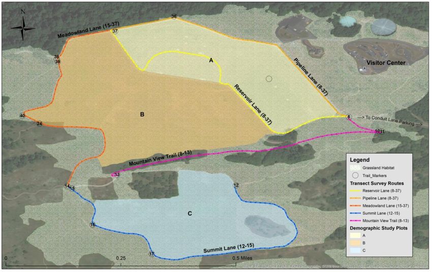
01 April 2021

Our commitment:
   • Provide training and scheduling for surveyors
   • Supporting your experience, including technical support
   • Share the results

Your commitment:
   • Attend two training sessions: 1) Virtual Training – Survey Orientation (Friday, April 2, 2021, 8:00
       AM); 2) Field Training at Powell Butte Nature Park (Thursday, April 8, 2021, 7:30 AM).
   • With a partner, complete 2-3 surveys each on 2-3 different days. Each survey takes about 30
       minutes, so the total surveying time is 2-4.5 hours. Surveying includes walking survey routes
       and recording your bird sightings using the online data platform eBird.

Preparation
   • Create an eBird account on the website www.ebird.org (remember your username)
   • Email your eBird username to Dr. Tom Virzi at tvirzi@conservationinsight.org. Tom will use this
       to share the survey routes with you so they will be available to you through eBird.
   • Download the eBird app on to your mobile phone.
   • Read through the Powell Butte bird survey eBird help guide (emailed as a separate document).
   • Read through this guide and familiarize yourself with the birds you’re likely to see/hear (see list
       at the end of this document).
   • If interested, the following 3 mobile apps are great for identifying birds during your survey:
       “Merlin Bird ID” (free), “Sibley” ($19.99), or “iBird Pro Guide to Birds” ($9.99)
   • Please have your personal calendar ready at the orientation session. We will be doing signups
       for the surveys at that time.

Safety

You will be surveying on established trails within Powell Butte Nature Park, a public park managed by
Portland Parks & Recreation. Most of these trails are graveled and have a gentle slope (0-5% grade).

    •    Please stay on the trails to avoid trampling vegetation and disturbing ground-based wildlife.
    •    Although dogs on leash are allowed in the park, we ask that you not bring them on the surveys.
         This will help maximize the number of birds you see and hear.
    •    If you encounter any park visitors with off-leash dogs or exhibiting other behavior you
         know/think is not permitted in the park, please do NOT challenge them. You can report it later.
         Occasionally we run into aggressive people and we’d prefer to avoid confrontations.
    •    We anticipate rain/inclement weather during the spring months. Unless you feel the weather
         poses a safety risk, please survey even in light rain.

Travel & Location

The main entrance to Powell Butte Nature Park is located at SE Powell & 162nd. The address, for
mapping purposes is 16160 SE Powell Blvd, Portland, OR 97236. Turn south at this intersection and drive
to the top of the hill and park near the Visitor Center. We will meet at the Visitor Center for the Field
Training on Thursday, April 8, 2021 at 7:30 AM.

                                                                                                Page 2
01 April 2021

The main gate to the park opens at 7:00 a.m. If you arrive for your surveys earlier than 7:00, you will
need to walk up the hill (~0.3 mi) or drive to the Anderegg Loop trailhead on the east side of the park
and walk to the visitor center on the trail. For directions to this trailhead, refer to the map at the end of
this document.

Preparing for the Surveys

Partners. We prefer that you conduct surveys with a partner. Occasionally a single surveyor may miss a
sighting or song/call, so a pair of surveyors can often get more complete data. We realize that
coordinating schedules may be difficult, so we’d rather have you participate solo than not at all. We will
be filling in our names on a chart during the orientation as the method of scheduling the entire 10
weeks.

COVID Protocol. In order to keep everyone as safe as possible and reduce the risk of inadvertently
spreading COVID-19, we are requiring that surveyors wear proper masks and maintain at least 6 feet of
distance between surveyors when conducting surveys with anyone who is not a member of your
immediate household. By participating in these surveys, you agree to follow our COVID protocol. If you
have a medical condition that does not permit you to wear a mask, please inform us of this before
conducting surveys with partners who are not members of your household.

Transects. There are five transects in this project. Each transect is about 0.6 miles, a distance we’d like
to have you complete in 30 minutes. This distance & time has been chosen to provide complete
coverage to make optimal use of your time. We’d like to have you sign up to survey at least 2 transects
each time you visit (1 hour total). If you’d like to do more, great!

You will notice that each of the five transects have two numbers in the name, such as the “8-37” in the
“Powell Butte--Pipeline Lane (8-37)” transect. These numbers correspond with the beginning and
ending trail map junction numbers, identified on the waist-high yellow metal trail junction markers.
These serve as field markers to help confirm you’re at the right location. When you choose your
transect on eBird, confirm you’re on the right transect by looking at the yellow trail marker.

Trail closure sign. The “Powell Butte--Reservoir Lane (8-37)” transect has a “Seasonal Trail Closure” sign
at both ends of the route. This is the transect that crosses on top of the lower water supply reservoir.
This closure sign is to protect ground-nesting birds. As surveyors, you are permitted to walk behind
these signs. Portland Parks is requesting that all surveyors who enter the closed area wear yellow safety
vests (provided) when conducting surveys while walking within this area.

Here’s a list of birds you are most likely to see or hear on our transects between Apr-Jun. They are
included here in case you want to review them for visual/auditory ID.

 American crow                       Chestnut-backed chickadee            Orange-crowned warbler
 American kestrel                    Common yellowthroat                  Red-breasted nuthatch
 American robin                      Dark-eyed junco                      Red-tailed hawk
 Anna’s hummingbird                  Downy woodpecker                     Ruby-crowned kinglet
 Bald eagle                          Golden-crowned kinglet               Savannah sparrow
 Band-tailed pigeon                  Golden-crowned sparrow               Song sparrow
 Barn swallow                        House finch                          Spotted towhee
 Bewick's wren                       House sparrow                        Stellar jay
 Black-capped chickadee              Lazuli bunting                       Turkey vulture

                                                                                                    Page 3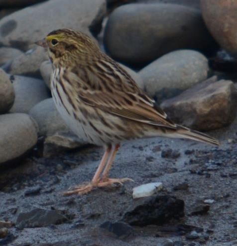
01 April 2021

 Black-headed grosbeak             Lesser goldfinch                         Violet-green swallow
 Brown creeper                     Mallard (usually flyovers)               White-crowned sparrow
 Brown-headed cowbird              Northern flicker                         Wilson's warbler
 California scrub jay              Northern harrier                         Yellow-rumped warbler

Although there are many other, less common birds you may encounter, please review the ID for the
Vesper sparrow. Although this is rare, it was seen for an extended period in 2018 and bears a strong
resemblance to the Song sparrow and Savannah sparrow, and will hang out with the Savannahs.

The focal species of this research is the Savannah sparrow. After you’ve encountered one a few times, it
will be easy to identify. On our transects, Savannah sparrows are most often found in the open expanse
of short grass and in blackberry thickets. Here are some important identifying characteristics.

                                               •    Yellowish stripe over eye (supraloral)
                                               •    Medium-sized sparrow with fairly small bill and short tail.
                                               •    Brown, streaked back
                                               •    Crisp, brown streaks on white breast

                                               Song: During breeding season, the male sings a three-part
                                               song that lasts 2 to 3 seconds: opening with a few quick
                                               notes; then a high, thin, insect-like buzzy middle; and, ending
                                               with a quick lower trill.

                                               Call: Like many grassland sparrows, this species uses short
                                               chip notes when alarmed, warding off intruders, or
                                               approaching its nest. A typical chip note is a soft, hissing tss.

The Western meadowlark is another important grassland species present at Powell Butte, though these
birds may be gone by the time the surveys begin.

                                               •    Chunky, short-tailed with a flat head, long slender bill.
                                               •    Round shouldered posture.
                                               •    Breeding adults have bright yellow underparts with a
                                                    prominent black V on the chest.

                                               Song: complex, two-phrase “primary” song that begins with 1–6
                                               pure whistles and descends to a series of 1–5 gurgling warbles.
                                               Males develop a repertoire of up to a dozen songs, and may switch
                                               the songs they sing in response to an intruder.

                                               Call: low, bell-like pluk or chupp. Adults use the weet note when
                                               migrating.

                                                                                                         Page 4
01 April 2021
Grassland Bird Survey Protocol
Survey Routes: We have created 5 predetermined line transect survey routes at Powell Butte Nature
Park along existing trails (see Figure 1: Survey Route Map below – a larger map for printing is also
attached). Routes were designed so that surveys would take approximately 30 minutes to complete, and
placed so that volunteers could conduct multiple surveys while looping back to the Visitors Center
parking lot in one morning. We anticipate that most volunteers will conduct at least 2 surveys per
morning; however, some volunteers may choose to conduct more. Note that the main park entrance
leading to the PBNP Visitor Center may be closed when you arrive for early morning surveys. Thus, we
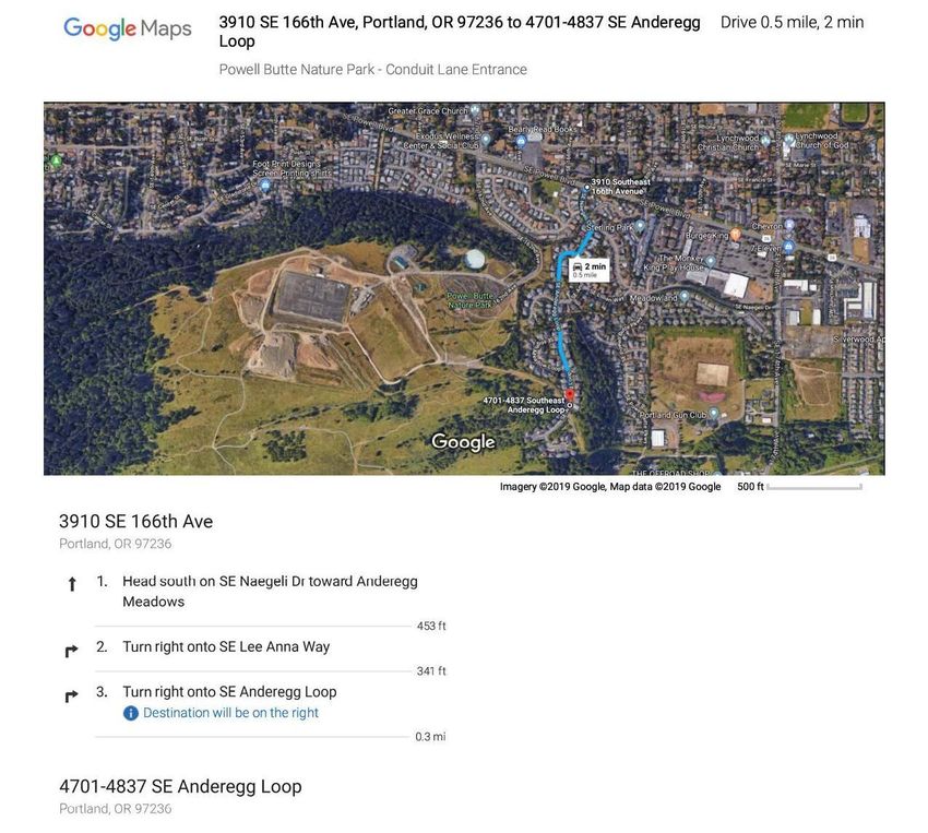
recommend entering the Park from the Conduit Lane entrance which is always open (see Figure 2:
Directions to PBNP Conduit Lane Entrance).
Survey route names generally follow established trail names at Powell Butte Nature Park. However,
please not that some of our predetermined routes actually follow more than one trail (e.g., our
Meadowland Lane route actually begins on Pipeline Lane before turning onto Meadowland Lane). To
avoid confusion, we have included a start and end point (number) as part of our survey route names.
These numbers follow the numbers on designated trail markers at PBNP (yellow poles) so you can be
certain you are following the proper route. You may start at either number – it doesn’t matter which
direction you walk on the survey route as long as you start and end at the proper numbers.
Transect/Survey Routes
eBird Location Name Length Notes
Powell Butte--Reservoir Lane (8-37) 0.59 m Seasonal closure – access granted for our surveys.
Joins Meadowland Land and Pipeline Lane transects
at marker 37.
Powell Butte--Pipeline Lane (8-37) 0.62 m Remember to focus on meadows (not forest) – but
count all birds observed. Joins Meadowland Lane
and Reservoir Lane transects at marker 37.
Powell Butte--Meadowland Lane (15-37) 0.60 m Actually starts on Pipeline Lane at marker 37 – begin
counting birds there. Continue to turnoff for
Meadowland Lane at marker 38. Connects to
Summit Lane transect at marker 15.
Powell Butte--Summit Lane (12-15) 0.64 m Only survey the section between markers 12 and 15
– do not count birds on remainder of loop. Connects
to Meadowland Lane transect at marker 15.
Powell Butte--Mountain View Trail (8-13) 0.51 m Focus survey effort on meadows below this trail –
but count all birds observed.
Survey Dates: We will attempt to conduct 10 repeated surveys (one survey per week) along each line
transect (i.e., survey route) during spring/summer 2021 (April 15 – June 30). Volunteers will be asked to
sign up for at least two days during this period. However, more data are always better! So volunteers
can conduct as many additional surveys as they like during the season.
Page 5
01 April 2021

Survey Duration: Each survey route should take approximately 30 minutes to complete. You may take
longer to complete a survey, especially if are finding a lot of birds. However, please try to limit the
amount of time it takes to complete your survey to 45 minutes maximum so effort among volunteers
will be somewhat consistent. Also, please spend a minimum of 20 minutes completing your survey even
if you aren’t finding many birds. You may need to increase or decrease your pace as you conduct your
survey to stay within these time limits.

Time of Day: Transect surveys for landbirds (i.e., passerines and raptors) are dependent on time of day
since birds are generally more active in the early morning. Thus, volunteers should attempt to conduct
surveys in the early morning – completing surveys no later than 3 hours after sunrise. In general, you will
need to start your last survey of the morning no later than 2 hours after sunrise to follow our protocol. If
circumstances cause surveys to be completed later in the morning the data are still useful to us;
however, please avoid conducting surveys midday or in the afternoon for data consistency.

Weather Conditions: Transect surveys should not be conducted in rain heavier than a light drizzle or
intermittent light rain showers, high winds, heavy fog (< 100 yds visibility), or other conditions that
substantially reduce bird activity or your ability to detect bird activity. We would like volunteers to
record weather conditions at the start of the survey including temperature (estimated is OK), sky cover
and wind level (using the codes below). These data will be submitted with your bird lists (see slides for
Entering eBird Data) in the comments section.

    Sky Codes:                                         Wind Codes:
    0 = clear, or few clouds                           0 = less than 1 mph; calm conditions
    1 = partly cloudy (half-clouded)                   1 = 1-3; wind direction shown by smoke
    2 = mostly cloudy (overcast; few sky openings)     2 = 4-7; leaves rustle at times
    3 = fog or smoke                                   3 = 8-12; leaves and twigs in constant motion
    4 = light drizzle                                  4 = 13-18; raises dust and loose paper
    5 = rain showers                                   5 = 19-24; small trees sway

Disturbance Data: As part of your survey we would like you to record anything you see that might be
disturbing birds along your route. This information will be recorded in the Checklist Comments on your
eBird list (see slides for Entering eBird Data). Common activities you might see include dogs off leash,
people walking off trails in prairies, people on trails in closed areas (e.g., on Reservoir Lane), people
flying drones, etc. Record any activities you think could influence bird activity or behavior along your
survey route. IMPORTANT: Please do not engage anyone about these activities while conducting your
survey – you can always tell park personnel later if you want.

Counting Methods: Walk slowly and quietly along your route while conducting surveys to increase your
chance of detecting birds. Please stay on trails at all times while conducting your surveys. Every once in a
while, stop, listen, and look around for birds – especially in the meadows. Count all birds that you see (or
hear) along your survey route, regardless of distance from you when detected. Only record birds you
can confidently identify (by sight or sound) – don’t worry if you miss a few! Include birds seen flying
overhead (e.g., flocks of geese). We want you to record everything you see (or hear) so we can create a
comprehensive bird list for Powell Butte Nature Park!

                                                                                                  Page 6
01 April 2021
Counting birds can be difficult if you’ve never tried to do this before. It is very easy to double-count
individuals. Here are some tips to reduce the chance of this happening (we’ll go over this in greater
detail during our training sessions):
1. When you start your survey stand still for a few minutes and look and listen around you. Start
identifying species and counting individuals here. We want you to record all the birds you detect
here, even if they are located before the start point for your survey route.
2. As you walk along the survey route you want to be careful not to double-count those same
individuals you already recorded at the start of your survey. Sometimes this is easy (e.g., you see
a Kestrel flying overhead at the start and then see it again as you begin to walk – count this as 1
Kestrel). Sometimes it is very difficult (e.g., you hear some Juncos singing at the start and then
hear some again as you begin to walk – are these the same Juncos singing?). Just be mindful of
this issue and do the best that you can – we expect some counting difficulties. Use your
judgement and always be conservative when counting.
3. As you walk on your survey route concentrate on counting the birds ahead of you, keeping in
mind birds may be flushing ahead of you as you walk. Do the best that you can trying to
determine if they are the same birds moving along with you. Count them as new individuals only
if you are relatively sure they aren’t birds you already counted. You may also count birds behind
you if you are relatively certain that you did not already count them – a great example is if you
see/hear a new species behind you that you did not record previously.
4. Raptors flying overhead can be challenging to count. You may see a Kestrel hunting at the start
of your transect, then see another one near the end. Use your best judgement as to whether
this is a second Kestrel or the same individual. Be conservative and only count it once if you’re
unsure.
5. Counting flocks of birds is also challenging. For large flocks we suggest counting in tens (or even
hundreds for very large flocks). Don’t get too hung up on getting a very precise count – we
accept that counts of flocks will not be very precise. With practice you can actually get pretty
good at estimating flocks sizes!
6. At the end of your survey route do the same thing that you did at the beginning – take a few
minutes to record all the birds in the area around you. However, some of our survey routes
connect directly with each other (on purpose). If you are conducting more than one survey in a
morning and your routes end/begin at the same point you need to be more careful about
double-counting birds on both routes. In this instance, you should not record any birds detected
past the end point of your first survey route. Rather, wait until you start your next survey route
to record these birds.
Page 701 April 2021
Figure 1: Survey Route Map
Page 801 April 2021
Figure 2: Directions to PBNP Conduit Lane Entrance
Page 9You can also read