PREPAREDNESS AND EXPERIENCES OF EVACUEES FROM THE 2016 FORT MCMURRAY HORSE RIVER WILDFIRE - UNIVERSITY OF ALBERTA
←
→
Page content transcription
If your browser does not render page correctly, please read the page content below
Article

Preparedness and Experiences of Evacuees from the
2016 Fort McMurray Horse River Wildfire †
Tara K. McGee
 Department of Earth and Atmospheric Sciences, University of Alberta, Edmonton, AB T6G 2E3, Canada;
 tmcgee@ualberta.ca
 †   This manuscript is an extended version of the conference paper “Residents’ experiences of the 2016 Fort
     McMurray Wildfire, Alberta”, presented at the 8th International Conference on Forest Fire Research.

 Received: 18 February 2019; Accepted: 3 March 2019; Published: 6 March 2019

 Abstract: The 2016 Fort McMurray Horse River Wildfire that caused the evacuation of more than
 88,000 residents from the Regional Municipality of Wood Buffalo (RMWB), Alberta is the largest
 wildfire evacuation in Canadian history. This paper presents results of an online survey of 447
 evacuees in June when some residents had returned to RMWB, and others were still living
 elsewhere. Results of this online survey show that many survey respondents were not aware of the
 high wildfire risk leading up to May 3rd and social cues indicated they should carry on as usual.
 Many respondents received little if any warning time to enable them to prepare. Most respondents
 had a vehicle, but traffic impediments caused some to run out of gas, food and water on the drive
 away from Fort McMurray. Most respondents stayed in more than one location, with most staying
 with friends and family for at least part of the evacuation. Some respondents faced challenges
 including financial difficulties, finding suitable accommodation, and dealing with insurance, and
 some received insufficient information. Help was offered to evacuees by a vast array of sources
 including organizations, businesses, communities, and residents. The results of this study show that
 most survey respondents were not prepared before they had to leave, which increased reliance on
 help provided by others.

 Keywords: wildfire; evacuation; preparedness; risk perception; social cues; environmental cues;
 warning; traffic; host communities; accommodation; help; support

1. Introduction
     Evacuations are used in Canada and elsewhere to protect public safety in the event of a wildfire
and other hazards. Mandatory evacuations require residents to leave, while voluntary evacuations
enable residents to choose whether or not to leave. Researchers in several countries have examined
residents’ wildfire evacuation intentions during a potential future wildfire [1–4], and decision-
making and actions during an actual wildfire [5–9]. These studies provide important insights into
whether or not residents will take recommended protective action and factors that influence their
intentions and actions.
     Researchers have also examined the impacts of wildfire evacuations on the health and well-
being of evacuees. Existing research clearly shows that wildfire evacuees experience stress and
anxiety during the evacuation process due to disruptions in daily routines, loss of control, uncertainty
about personal safety and the safety of their homes, and proximity of danger [1,10,11]. Social support
has been found to reduce negative impacts of wildfire evacuations for evacuees [12]. Scharbach and
Waldram [13] examined the impacts of the wildfire evacuation of Hatchet Lake Denesuline First
Nation and found that splitting up families during the evacuation negatively affected their wellbeing.
Kent and colleagues [11] found that evacuations may have positive impacts when people have an
opportunity to get to know one another. Communication also affects the wellbeing of evacuees, with

Fire 2019, 2, 13; doi:10.3390/fire2010013                                          www.mdpi.com/journal/fire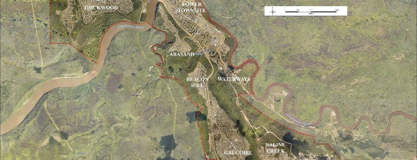
Fire 2019, 2, 13 2 of 16
inadequate communication increasing distress and abundant and timely information helping
residents to cope with the stressful situation [14–16].
Only a small number of studies has examined in detail the experiences of wildfire evacuees
during the process of evacuation. Cohn and colleagues [1] examined evacuation experiences of
residents during three fires in the United States: Hayman Fire in Colorado (More than 5000 evacuated
for 1–2 weeks), Rodeo-Chediski fire in northern Arizona (more than 32,000 evacuated for 1–2 weeks),
and Cave Gulch/Bucksnort Fires in Montana (50–100 evacuated for 2–3 days). The researchers
compared the perspectives of evacuees and public safety officials during five temporal evacuation
stages: Anticipation, evacuation warning, displacement, notification of condition of home, and return
and recovery. This study provides a valuable overview of wildfire evacuations from the perspectives
of evacuees and emergency managers, however does not examine residents’ evacuation experiences
in detail, including the process of leaving their home and community and travelling to safety.
Scharbach and Waldram [13] examine the concept of being ‘at risk’ and describe the evacuation
experiences residents of Hatchet Lake Denesuline First Nation, a remote fly-in community of 1300
people in northern Saskatchewan, Canada which was evacuated for 10 days. The evacuation of
Hatchet Lake Denesuline First Nation by air involved separation of families based on risk assessment
which caused considerable distress and those deemed to be at low risk experienced social, cultural
and health challenges. Further study is needed to examine evacuations in other contexts.
Being well prepared enables residents to effectively take protective action during a wildfire, in
this case by evacuating [17]. For residents, preparedness before an evacuation includes being aware
of the local wildfire risk and the potential need to evacuate, having a plan for how to evacuate if
required to do so, and having emergency supplies organized in advance. Only a small number of
studies have examined residents’ preparedness to evacuate due to wildfire. McLennan and
colleagues [18] examined seven post-fire studies in Australia and found that only between 6–27% of
residents who planned to evacuate had an adequate level of preparation to leave safely. McNeill and
colleagues [19] examined high wildfire risk communities that had recently experienced a wildfire in
Western Australia, and found that perceived risk severity predicted greater evacuation preparation.
Further study is needed to examine residents’ preparedness for wildfire evacuation.
The present study contributes to existing literature by examining the wildfire evacuation
experiences of residents of urban Fort McMurray in the Regional Municipality of Wood Buffalo,
Canada who evacuated for one month or more due to the Horse River fire which destroyed 2400
homes in Fort McMurray and caused the evacuation of more than 88,000 residents. The two research
questions that guide this study were:
(1) How prepared were residents to evacuate on 3 May 2016?
(2) What were residents’ experiences leaving their home and community, and staying in a safe
place?
Lindell and Perry’s (2012) [20] protective action decision model (PADM) describes stages that
occur before someone takes protective action, therefore will provide insights into the process that led
up to the evacuation of residents from Fort McMurray. The first stage in PADM is a pre-decision
process including reception, attention and comprehension of warnings; or exposure, attention and
interpretation of environmental/social cues. The next stage includes perceptions of threats, protective
actions, and stakeholders. Once the pre-decision process is complete and core perceptions activated,
the next stage involves risk identification, risk assessment, protective action search, protective action
assessment, and protective action implementation. The outcome of this process may be influenced by
situational factors and impediments.
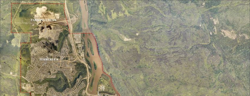
The Regional Municipality of Wood Buffalo (RMWB) is located in the boreal forest of north-
eastern Alberta (see Figure 1). RMWB includes the Fort McMurray urban centre and several rural
settlements, including First Nations and Métis communities. The 2016 Census [21] provides
information about the RMWB. The population of RMWB in 2016 was 71,589 persons, with 66,573
residents living in urban Fort McMurray. The average age in RMWB was 33.1 compared to 37.8 for
the province of Alberta. The population of RMWB is multicultural, with more than one quarter of the
population (26.7%) in 2016 a visible minority, slightly higher than the provincial average of 23.5%.Fire 2019, 2, 13 3 of 16
9.2% of the population in RMWB declared Aboriginal identity, compared to 6.5% for the province.
Formal education levels were higher than the provincial average, with 59.6% of the population 15+
in RMWB having a postsecondary or trades certificate or diploma (55.2% for Alberta); 29.3% having
a high school diploma (compared to 27.9% for Alberta); and 11% having no certificate, degree, or
diploma (compared to 16.9% for Alberta). Employment rates and incomes are high, with a 72.6%
employment rate in RMWB compared to 65.4% for Alberta as a whole. Household incomes are also
high, with the median total income of RMWB households $195,570 in 2015, compared to $93,835 for
the Province of Alberta; and at the individual level, the average total income of residents was $77,481
compared to a provincial average of $42,717. However there is considerable disparity, with 77% of
the Fort McMurray population 15+ earning more than $100,000/annum, and 18% earning less than
$20,000 per year. House values are also high, with the average value of dwellings $619,344 compared
to $449,790 for the province of Alberta. In 2016, 67.6% of the 25,660 private households were owned,
while 32.1% were rented, and 0.4% were First Nation band housing. The Regional Municipality of
Wood Buffalo is home to oil sands development and related industries, with 30% of the labour force
working in this industry. Two other major industries that employ local residents are construction
(10%) and retail trade (8%).
Figure 1. Location of the Regional Municipality of Wood Buffalo, Alberta. Source: Regional
Municipality of Wood Buffalo (https://www.rmwb.ca/living/Communities.htm).Fire 2019, 2, 13 4 of 16
The Horse River fire started on May 1st, 2016, and quickly grew in size due to extremely hot and
dry conditions. At 8pm on May 1st, residents in Centennial trailer park were warned to leave their
homes, with residents in Beacon Hill and Gregoire neighbourhoods on evacuation alert (see Figure
2). Two hours later, a state of local emergency was declared and a mandatory evacuation was ordered
for residents of Centennial RV Park Campground, Prairie Creek and Gregoire. The next morning, the
mandatory evacuation for Gregoire and Prairie Creek were rescinded. The wildfire continued to
grow throughout the day on May 2nd, and at 8pm the fire reached the Athabasca River. Overnight,
the fire jumped the Athabasca River (approximately 1 km distance).
Figure 2. Fort McMurray neighbourhoods. Source: Regional Municipality of Wood Buffalo.
For residents in Fort McMurray, the skies appeared sunny and clear the morning of May 3rd,
with the smoke staying close to the ground due to a thermic inversion. At 11:00 am, representatives
from the RMWB and the Provincial government held a media briefing. The media and residents wereFire 2019, 2, 13 5 of 16
told that fire conditions were extreme and were expected to worsen throughout the day. Residents
were told by the Fire Chief that they should be prepared to act on short notice by having “a little plan
in mind if you were told you had to leave your house, what would you take with you and where do
you think you might go.” However residents were also told to carry on as usual, with the Fire Chief
saying “people need to get on with their lives, people need to go to work, Mom needs to take the kids
to school, and Dad takes the guys to the ball game afterwards”
(https://www.youtube.com/watch?v=55O3jp8thKM).
At 1:15pm, the wildfire crested the hills along the west side of Fort McMurray, becoming visible
to many residents [22]. At 2:31 pm, the wildfire entered the Beacon Hill neighbourhood. Three
minutes later, at 2:34, an evacuation was ordered for Abasand, Grayling Terrace, and Beacon Hill
neighbourhoods. The Thickwood neighbourhood was on a voluntary evacuation. At 2:52, the wildfire
was sighted south of Thickwood, and at 3:31, an evacuation was ordered for the Thickwood,
Gregoire, Waterways neighbourhoods, and Centennial Trailer Park. At 4:24, an evacuation was
ordered for downtown Fort McMurray. At 5:30, Dickinsfield, Draper, Lower Townsite, Saline Creek,
and Wood Buffalo were ordered to evacuate. At 6:49, all of Fort McMurray was ordered to evacuate.
Due to traffic congestion on Highway 63, the one access road out of Fort McMurray, people living in
neighbourhoods north of the Athabasca River were told to evacuate by driving north on Highway
63, while those living south of the river drove south. The estimated 15,000 to 20,000 evacuees who
headed north stayed in industry work camps and Fort McKay First Nation. On May 4 after the fire
started to head north and supplies in work camps began to run out, evacuees were either flown south
to the cities of Edmonton or Calgary, Alberta, or drove back through Fort McMurray to communities
south of RMWB.
In total, more than 88,000 residents of urban Fort McMurray and surrounding communities in
RMWB evacuated their homes and communities due to the Horse River fire. By the time the fire was
deemed to be under control on 4 July 2016, the fire had destroyed 2579 structures in Fort McMurray,
and burned 589,552 hectares. Two young women died in a car crash on highway 63 during the
evacuation. Government responses to this wildfire, including the evacuation, have been examined in
studies completed by consulting companies following the wildfire [22–24]. These studies provide
important insights into the government response to the wildfire, however further study is needed to
examine the experiences of residents who fled from their homes and neighbourhoods in Fort
McMurray.
2. Materials and Methods
This project started in May 2016 while residents of RMWB were still away from their homes and
communities. Before data collection commenced, this study received ethics clearance from the
University of Alberta’s Human Research Ethics Board 1. An online survey was selected as the data
collection tool because it provided a way to contact evacuees who were staying in a variety of
locations after fleeing from their home and communities. A short online survey was also appropriate
for people who were very busy during and after the evacuation. It also provided a way to obtain
information quickly from evacuees so that the details of their experiences would be fresh in their
minds. An online survey also provided a way to obtain input from many evacuees [25].
The survey was developed by the author and a research assistant in May and early June. Closed-
ended and open-ended questions were included, and the survey was designed to be completed
within 10 minutes. Careful consideration was given to the questions included in the survey and
wording of questions, given the sensitivity of the topic. Once the survey was prepared, it was emailed
to two RMWB evacuees for feedback. Slight changes were made in response to feedback, and the
survey was finalized in mid-June. The survey included questions about evacuees’ initial evacuation
experiences, including learning about the wildfire, leaving, and staying elsewhere. Purposive
sampling was used to try to recruit as many wildfire evacuees as possible. Once the survey was
finalized, evacuees were recruited through the Facebook ‘Fort McMurray Evac Relocation Group’
and Twitter. Two First Nations and one First Nation organization in RMWB were also invited to post
the survey on social media. At the time of this online survey, this was the first collection of data fromFire 2019, 2, 13 6 of 16
evacuees from the Horse River fire. A total of 447 respondents completed the online survey, with
most completing the survey within the first 24 hours that it was posted online on June 21, 2016.
Descriptive statistical data analysis was completed using Survey Monkey.
The 447 respondents included 94% who normally lived in the Fort McMurray urban centre,
while the other 6% lived in other communities in RMWB. Survey respondents included adults in a
range of age groups from 18–25 to 75+ (Table 1). The survey was mainly completed by women (Table
1). Most respondents were employed, with 63.5% in full-time paid employment, 8.0% self-employed,
8.0% in part time/casual employment. 8.5% full time domestic/parenting duties, 7.7% unemployed1,
4.9% retired, 1.8% and 2.6% did not provide their employment status. 8.1% of respondents were born
in RMWB, 16.4% were born elsewhere in Alberta, with most respondents (66.9%) born elsewhere in
Canada, and 8.6% were born outside of Canada. At the time of the wildfire, respondents had lived in
their community in RMWB for varied lengths of time, with a median of 6-10 years (Table 1). Survey
participants were asked how their home was affected by the wildfire. While most survey respondents
reported that their home either had no (36%) or minor (41%) damage, 18% of respondents stated that
their home was destroyed in the fire, and 3.6% of respondents said their home had suffered major
damage.
Table 1. Demographic characteristics of online survey participants.
Length of Time Living in Community Where You Normally Live Age Gender
(Before the Evacuation (n = 390)) Characteristics (n = 389) (n = 389)
Less than 1 year 4.1% 18–24 3.9% Female 81.2%
1–5 years 28.2% 25–34 25.5% Male 16.7%
6–10 years 28.5% 35–44 29.0% Other 0.3%
11–20 years 19.7% 45–54 25.5% No response 1.8%
More than 20 years 19.5% 55–64 13.1%
65–74 2.1%
75+ 2.1%
3. Results
3.1. Preparedness
Fort McMurray is located in the fire prone boreal forest [26], and wildfires have occurred near
Fort McMurray every few years in the past two decades, including significant wildfires in 2015, 2011
(3 fires), 2009 (2 fires), 2007, and 2003 [27]. Five large wildfires came within 20km of Fort McMurray
between 1990 and 2012 [28]. The weather leading up to the 2016 wildfire season included a very dry
and mild winter, followed by an unusually hot and dry spring [29]. In the last week of April, the Fort
McMurray area experienced daily high temperatures in the 30s, low relative humidity of 15 percent,
and winds approaching 25 km/hour [24]. Despite the location of the community in the boreal forest,
past wildfires in the area, and weather leading up to the beginning of May 2016, when survey
participants were asked to think back a few days before the evacuation and recall how they rated the
wildfire risk, 44.8% perceived the threat to their community as being low or very low, with 28.7%
recalling the risk as being moderate, and 25.5% perceiving the risk as high or very high (Table 2).
Most survey participants also perceived the wildfire risk to their property and family as low to very
low. As expressed by one respondent:
“Right up until my friends said they could see flames in our neighbourhood I felt like things
weren’t too bad, I was in denial about the severity of the threat.” (Respondent #267).
1 The unemployment rate in RMWB at the time of the survey was 6.8% (Statistics Canada 2017)Fire 2019, 2, 13 7 of 16
Table 2. Survey participants’ rating of the wildfire threat a few days before the evacuation on a scale
from ‘1’ no threat to ‘5’ very high threat (n = 418).
‘5’ N/A
‘1’ ‘2’ ‘3’ ‘4’
Very (I did not St.
no Low Medium High Total Mean
High Think Dev.
Threat Threat Threat Threat
Threat about It.)
Perceived wildfire risk
21.6% 33.3% 25.2% 11.5% 6.7% 1.7% 417 2.48 1.2
to my family
Perceived wildfire risk
30.5% 36.1% 16.1% 10.1% 5.8% 1.4% 416 2.23 1.2
to my property
Perceived wildfire risk
10.6% 34.2% 28.7% 15.4% 10.1% 1.0% 415 2.8 1.1
to my community
Beliefs that the wildfire risk was low or moderate despite environmental cues to the contrary
were likely influenced by social cues which indicated that people should carry on as usual.
Information received from trusted individuals downplayed the risk, for example the Fire Chief’s
advice to residents that the risk was high but they should carry on with their normal activities. One
respondent explained:
“Had I known how close the fire was to the city, I would have left that morning. I asked a fire
captain the day before and he told me it was far away and not to worry.” (Respondent #216)
Children went to school on May 2nd and 3rd, and businesses were also open. This meant that
parents had to return to school to pick up their children before they evacuated, and in some cases
teachers took children out of the city in their own vehicle when parents were unable to pick them up
at the school. People who were at work until the mandatory evacuation was ordered had little if any
time to prepare to leave. As two respondents explained:
“Children should not have been in schools on Monday or Tuesday [May 3rd]. Nor should we as
staff. Evacuation should have been called a lot sooner. A school shouldn’t have had to take
children out in cars.” (Respondent # 179)
“Employees were kept at work because it wasn’t a mandatory evacuation and didn’t have
adequate time to go back and retrieve any belongings.” (Respondent # 233)
Most survey respondents (96.7%) also indicated that this was the first time they had evacuated
due to wildfire, with only 3.3% (13 respondents) having prior evacuation experience. Only two of
these respondents had experience evacuating from RMWB due to wildfires before 2016, while other
wildfire evacuation experiences were elsewhere in Canada.
Mandatory evacuations were ordered for Fort McMurray neighbourhoods throughout the day
on May 3rd. However by the time the official evacuations were ordered, the wildfire was already
clearly visible to Fort McMurray residents and homes had already started to burn in some
neighbourhoods. As three survey respondents explained:
“Unacceptable that the people in Beacon Hill and Abasand basically had the fire at their back
door before making their own decision to leave.” (Respondent #169)
“The city gave the residents of Beacon Hill no warning. When the warning came in at 2pm on
May 3rd, it was already too late as homes were already on fire and I was unable to get to my
house to collect anything.” (Respondent #132)
“The evacuation was very chaotic and we were not told to leave Beacon Hill until houses were
already on fire.” (Respondent #89)
When asked how they learned they would have to evacuate, the largest group of respondents
(19.9%) did not receive any warning but decided to leave because of the environmental cues that they
could see outside (Table 3). However many respondents received some form of notification from
official sources or others. Many respondents left after hearing information provided on the radioFire 2019, 2, 13 8 of 16
(19.4%), and others were notified by a family member (15.3%). 9.8% learned that they would have to
leave after seeing information posted on social media, 9.1% were told by their employer, and 7.9%
were told by a friend or neighbour that they would have to leave. A few respondents received this
information from an RCMP officer, TV or from the RMWB website [30].
Table 3. How respondents learned that they would have to evacuate (n = 417).
Cues Percentage
I decided to leave because of what I could see 19.9%
Radio 19.4%
A family member 15.3%
A posting on social media (Facebook, Twitter, etc.) 9.8%
My employer 9.1%
A friend or neighbour 7.9%
Alberta Emergency Alert 5.0%
An RCMP (police) officer 2.2%
TV 0.7%
The Regional Municipality of Wood Buffalo website 0.7%
Other 9.8%
Most survey respondents recalled that they were either at work or home when they learned they
had to evacuate. Many survey respondents had little or no time to prepare before they had to leave
[30]. Importantly, 11.7% (48 respondents) said that they spent 0 minutes getting ready to leave (Table
4). 16.9% said that they spent less than 15 minutes to get ready, while another 39.1% said that they
spent between 15 minutes and 1 hour getting ready. 16.6% spent between 1 and 2 hours to get ready
to leave, and only 8.6% said that they spent more than 2 hours getting ready. Survey respondents
also described the lack of preparation time:
“I wish the order of evacuation was made early as I left to pick up kids and I couldn’t go back
home. I left with no cloth[e]s or anything.” (Respondent #425)
“Evac should have been about an hour or two earlier. Those working north of town had no time
to go home and pack/prepare.”(Respondent #277)
Table 4. Time spent preparing to leave (n = 409).
Number of Minutes Percentage
0 minutes 11.7%
Less than 15 minutes 16.9%
15 minutes 10.3%
30 minutes 20.0%
45 minutes 8.8%
60 minutes 11.2%
75 minutes 1.5%
90 minutes 3.7%
105 minutes 0.2%
120 minutes 7.1%
More than 120 minutes 8.6%
The amount of time survey participants had to prepare before they left affected what they could
take with them. 409 survey respondents described what they brought with them when they
evacuated. 66.5% stated that they brought clothing, with most taking one change of clothes or enough
clothes for two to three days. As two participants explained:
“Pets, food for pets, medications, and clothes for 2 days. Believed they would have it under
control within a few hours, and we would get back home.” (Respondent #415)
“The dog, personal financial documents, change of clothes, passport, laptop, cellphone charger,
water.” (Respondent #285)Fire 2019, 2, 13 9 of 16
However, some respondents were able to take enough clothing for an extended period. As one
participant stated:
“Our sleeping bags, pillows, lots of water, clothing for a month in a suitcase, emergency travel
kit, fruit, granola bars, family photo album, block of Balderson cheese and a bottle of
Chardonnay.” (Respondent #401)
42.8% stated that they brought documents such as a passport and other important documents.
38.9% brought pets and pet-related items with them. 25.67% stated that they brought food with them,
with some who brought snacks for a short trip, while others brought enough food for a few days; and
22% brought water. Other items brought by many respondents include photos (19.8%), a computer(s)
or hard drive (14.7%), and sentimental items (13.9%). A few participants mentioned that it was
difficult to decide what to take. As one participant explained,
“I was in a daze as to what to take… nothing seemed important to me at the time, just getting
out safely.” (Respondent #31)
9.3% of respondents said they did not take anything with them. Only four respondents stated
that they brought an emergency kit/bag with them.
3.2. Leaving Their Home and Community
Most survey participants (86.1%) left their community in their household vehicle. However 7.4%
left in a vehicle of a neighbour or friend, a family member who lives elsewhere, or someone who they
did not know before the evacuation. A few respondents left in a company vehicle or with a co-worker,
a few left by bus, one left in their RV. Three respondents were told by the RCMP to leave on foot, as
one explained:
“Even though we left in our household vehicle, [we] had to leave the vehicle and run and the
fire was so close and the traffic was so bad. RCMP ordered us to ditch our vehicle and run.”
(Respondent #347)
52.7% of respondents reported that they had problems leaving their community [30]. Traffic
delays were common as residents were leaving their neighbourhood and then once they were on
Highway 63. Many residents’ vehicles ran out of gas, and some were not sure whether they should
go north or south on Highway 63. Some survey respondents were separated from family members
and friends, and others did not have enough food or water during the drive away from Wood Buffalo.
Many survey respondents had to leave while the fire was burning around them. In the words of two
survey respondents:
“I hope it is something I never have to experience again… Sitting in stand still traffic watching
fire coming towards you is something no one can imagine until you go thru it….” (Respondent
#31)
“We had to literally drive through mountains of flames to make it out… if we had to stop or
slow down we would have died in our car.” (Respondent #49)
At the end of the survey when respondents were invited to provide any additional comments,
three mentioned that residents were courteous as they were driving out of the city:
“I was impressed how courteous most people were on the drive out of town. Sometimes I
changed lanes in the long line of traffic as I did not know where I was going and people let me
into their lane.” (Respondent #59)
“…People would be letting you merge in when there were flames right beside your vehicle.”
(Respondent #78)
“Everyone was very calm while we evacuated Abasand. Everyone took their turns merging.
The fire was all around us as we left, but we kept our cool so we wouldn’t scare our daughter.”
(Respondent #362)Fire 2019, 2, 13 10 of 16
3.3. Staying in a Safe Place
Evacuees stayed in a variety of locations during the evacuation (Table 5). While 39.0% of
respondents stayed in one place for the whole evacuation, 61.0% stayed in more than one
town/city/community [30]. Residents who had to travel north out of Fort McMurray stayed in Fort
McKay First Nation or a work camp, then went south and stayed in a second community. For
example, Respondent #442 drove north and stayed in Fort McKay for one night, then stayed in
Edmonton for the rest of the time; while Respondent #270 stayed in a work camp for two days then
flew to the province of Ontario. Some evacuees travelled south but stayed near Fort McMurray the
first night, and then continued their journey south the next day. As one respondent explained, “We
first ran to Gregoire Lake, then next morning we again had to run for our life. When we ran again we
went to Spruce Grove (in the Edmonton Metropolitan Area)” (Respondent # 338). Nearly half of
survey respondents (218) stayed in the City of Edmonton, the closest city south of Fort McMurray, or
its surrounding metropolitan area. Some survey respondents travelled further south to Red Deer (13
respondents) or Calgary (56 respondents). 180 respondents stayed in other towns and communities
around Alberta. 138 respondents left Alberta and stayed in another province during their evacuation,
and nine respondents left Canada to stay in another country.
In these locations, survey respondents stayed in various types of accommodation (Table 6), with
some respondents staying in more than one type. Most people (72.6%) stayed with friends and family,
and half (50%) stayed in a hotel room. About 20% of respondents stayed in a camper or rented
apartment/house. Interestingly, 5% of respondents (21) stayed with someone they had not met before
the evacuation, and nine survey respondents reported that they slept in their vehicle.
Table 5. Where survey respondents stayed during their evacuation (n = 163).
In Alberta Another Canadian Province/Territory Outside Canada
Work camps in RMWB 21 British Columbia 45 United States 3
Anzac in RMWB 11 Ontario 35 Other Countries 6
Lac La Biche (220 km NE Edmonton) 24 Newfoundland 15
Athabasca (145 km North Edmonton) 16 Saskatchewan 14
Boyle (163 km North Edmonton) 10 Nova Scotia 11
Edmonton City or Metropolitan Area 218 New Brunswick 7
Red Deer 13 Manitoba 6
City of Calgary 56 Prince Edward Is. 3
Other towns and communities 180 Quebec 1
Northwest Territories 1
Table 6. Types of accommodation for survey respondents (n = 412).
Where Survey Respondents Stayed during the Evacuation Number of Respondents
I stayed with friends and family 299
A hotel room 206
A camper 91
A rented apartment or house 80
A work camp 25
I stayed with someone I had not met before the evacuation 21
A summer home/cabin 16
My own home outside of Fort McMurray 10
My car/truck 9
A cot in an arena 9
A rented room in a house or apartment 9
A room in a university/college dormitory 8
Other 14
Once they were staying elsewhere, most (81.8%) survey respondents stated that they did not
have any problems, while the remaining respondents experienced problems including financial
challenges, and trouble finding accommodation being the two most frequently mentioned concerns.Fire 2019, 2, 13 11 of 16
Challenges with insurance and finding accommodation that accepted pets were also mentioned by
several respondents. During the evacuation, survey respondents obtained information in a variety of
ways, with the main sources being social media (88.3%) and news (70.2%), followed by friends and
family (54.2%) and RMWB (46.8%) or Government of Alberta (46.3%). However 46.1% of survey
respondents stated that they did not receive enough information during the evacuation [30].
74.4% of survey respondents stated that they received help during the evacuation from a vast
array of sources including friends, family, strangers, aid organizations, the government of Alberta,
and businesses, to name a few. In the words of a few survey respondents:
“People were handing out food and water on the highway where traffic was backed up.”
(Respondent #416)
“In every town we stopped in people were amazingly kind and helpful, going out of their way
to do whatever they could to help and accommodate us.” (Respondent #294)
“So many people gave donations of food! Restaurants gave us free food, hotels have discounted
rates, and stores gave us discounts to buy new clothes. The help we received was astounding.”
(Respondent #238)
“My family helped, Red Cross, the government funding, my insurance company, and various
businesses were very generous. Evac centres.” (Respondent # 438)
“Complete strangers put me up in a camper in Leduc. They paid for the campsite the entire time
I was there.” (Respondent #433)
“The animal care centre at the evacuation centre was very helpful, and a neighbour drove out of
town with me and helped me with the driving.” (Respondent #432)
When asked what help they had received during the evacuation, one survey respondent simply
stated “Too many to list. It was unbelievable… the kindness was so humbling.” (Respondent #440)
People in communities near Fort McMurray provided shelter, food, and water. Residents in
Edmonton and elsewhere in Alberta invited evacuees to stay with them in their homes, volunteered,
and donated. Financial support from the Government of Alberta and the Red Cross, and donations
from other organizations were appreciated by survey respondents. However some survey
respondents experienced challenges accessing funds from the Red Cross.
69.82% of respondents stated that they had positive experiences during the evacuation,
including being thankful for the help they received, and experiencing the strength and resilience of
Fort McMurray residents. In the words of a few participants:
“Made some wonderful new friends and experienced the kindness of friends and strangers
alike along the way.” (Respondent #434)
“Many, many positive experiences in Edmonton of the generosity and compassion of the
community, the province, and the country at large, ranging from a free cup of coffee to the hugs
of strangers to the government debit card.” (Respondent #355)
Once the Government of Alberta allowed evacuees to start returning on June 1st, survey
respondents began to return to RMWB, with most returning within 4 weeks of June 1st (Table 7).
However some survey respondents stayed away until July or for longer. At the time of the
survey in late June 217 respondents reported that they had returned to RMWB, 154 stated that they
planned to return, 20 were planning to or had moved away from RMWB, and 17 were unsure of their
plans. Therefore most respondents either had or planned to return to RMWB, with less than 5% who
were not planning to return.Fire 2019, 2, 13 12 of 16
Table 7. Length of stay elsewhere (n = 406).
How Long Did You Stay away from Your Community? Respondents (%)
Less than 1 week 0.7
1 week 0.5
2 weeks 0.5
3 weeks 2.2
4 weeks 22.7
5 weeks 18.2
6 weeks 17.5
7 weeks 11.6
8 weeks 9.1
9 weeks 2.7
10 weeks 2.2
More than 10 weeks 12.1
Total 100
4. Discussion
The results of this study show that most survey respondents were not prepared to evacuate
when they had to leave their homes and communities. Many respondents were not aware of the very
high wildfire risk to their community, home or family preceding May 3rd, and social cues told them
to carry on as usual leading up to and on May 3rd, with schools and businesses open. For most
respondents, this was their first evacuation experience. Many respondents received little if any
official warning before they had to leave and instead left due to the environmental cues which made
it clear that the threat was immediate. However some received warnings from official sources, friends
and family, and other sources. Most respondents were able to take clothing and many took important
documents, however only ¼ of respondents mentioned bringing food and water. Fortunately, most
respondents had a vehicle that they used to evacuate, but some respondents relied on others to enable
them to leave. Some of those who had a vehicle experienced situational impediments due to road
access problems and traffic congestion. Some respondents ran out of gas, food, and water on the long
drive away from Fort McMurray. For many survey respondents, the evacuation was a multi-stage
process involving staying in more than one location. Most survey respondents stayed with friends
and family during at least one part of the evacuation. Although most respondents were looked after
once they arrived in a safe place, some respondents experienced financial difficulties, challenges
finding suitable accommodation, and problems dealing with insurance. Although media coverage of
this wildfire and evacuation was extensive, some respondents did not receive enough information.
Most survey respondents received help during this evacuation from a variety of sources throughout
the evacuation, which helped them to leave their home and community, reach a safe place, and meet
their essential needs (food, water, clothing, and accommodation) during the evacuation. The help
provided to survey respondents was remembered as a positive part of their evacuation experience.
The results that many respondents rated the wildfire risk to their community, property, or family
as low to moderate before May 3rd is surprising due to the conditions leading up to the start of this
wildfire, and studies which indicate that residents living in high wildfire risk areas are usually aware
of the risk [31–33]. Whittaker and colleagues [9] found a high level of awareness preceding the 2009
Black Saturday fires in Victoria, Australia, however this is likely partly due to extensive media
coverage to warn residents of the extreme fire risk [34]. In Fort McMurray, social cues indicated that
survey respondents should carry on as usual. The importance of early warnings for protecting lives
and reducing injuries is well established in the broader hazards [35–37] and in the wildfire literature
[38,39]. Very limited if any warning time provided to residents due to a wildfire also occurred five
years earlier in northern Alberta when residents of the Town of Slave Lake received little if any
warning when a wildfire entered their town in 2011 [40]. McLennan and colleagues [18] also found
that residents in Australia who planned to evacuate had a low level of preparedness.
The results of this study show that evacuees’ low levels of preparedness combined with long
traffic delays [30] made it difficult for people to evacuate, and increased residents’ distress as theyFire 2019, 2, 13 13 of 16
were leaving and once they arrived in a safe place. Despite leaving late and traffic delays, survey
respondents reported courteous driving on the way out of Fort McMurray, in line with research
which shows that panic behaviour is very unlikely to occur, particularly if people are evacuating with
people who are familiar to them including family, friends, and neighbours [41–43]. The findings that
almost 40% of survey respondents brought pets with them when they evacuated, and some
respondents had difficulty finding accommodation that would enable their pets to stay with them
confirms the need to identify ways to look after pets during evacuations [44].
Those survey respondents who were not prepared fortunately received support from others to
meet their basic needs, including transportation out of Fort McMurray, food, water, clothing, and
accommodation. Existing studies clearly show that residents and organizations within an area
affected by a wildfire [45,46] and other hazard events [47] provide important sources of help to those
directly affected. For example, Carroll and colleagues [45] found that after the Rodeo-Chediski fire in
the U.S., residents helped neighbours by providing shelter and support. In this case, the substantial
amount of help provided to evacuees from residents in other communities within RMWB, elsewhere
in Alberta, and beyond may be due to the number of people who evacuated, the extensive use of
social media and media coverage of this wildfire [48].
5. Conclusion
The Horse River (Fort McMurray) wildfire caused the largest wildfire evacuation in Canadian
history. The results of this study show that many survey respondents received little if any warning,
and were not aware of the wildfire risk and potential need to evacuate, which meant that most were
not prepared to leave and instead needed to rely on residents, communities, and service providers to
meet their essential needs. The non-random sampling approach in this study means that the results
presented in this paper cannot be generalized to the whole population of RMWB that evacuated due
to the May 2016 Horse River wildfire. The use of an online survey distributed through social media
meant that some people who do not use social media would not have been able to participate.
However, the results provide important insights into whether residents were prepared before they
had to evacuate due to this wildfire, and the experiences of evacuees leaving their home, travelling
to a safe place, and staying elsewhere during the evacuation that lasted one month or longer.
Additional research would be useful in several areas. Further examination of the helping behaviours
that occurred during the Horse River wildfire would be a valuable contribution. Research on the
experiences of evacuation host communities—those communities where residents stay during
evacuation—would also be very valuable.
Despite the limitation of the sampling approach used for this study, there are important
implications for authorities. The results of this study clearly show the need to increase the wildfire
risk awareness of residents living in Fort McMurray, the surrounding Regional Municipality of Wood
Buffalo, and in other communities at high risk from wildfires. Increased awareness will help to
encourage residents to prepare [20]. The results of this study also reinforce the importance of
providing timely warnings. The Government of Canada recommends that residents are prepared for
72 hours after an emergency. Although a few survey respondents had an evacuation kit and many
took enough clothing for 3 days and important documents, many survey respondents were not
adequately prepared. Further efforts should be made to increase preparedness of residents living in
high risk communities.
Funding: This research received no external funding.
Acknowledgments: My sincere thanks to the hundreds of evacuees who completed the online survey while
many were still evacuated and others had returned home and were in the early stages of the recovery process.
Thank you to Leah Anderson who prepared the online survey, and to Fort McMurray Evac Relocation Help
Group and others who posted the survey link on social media. Thank you to Miles Parenteau for assistance with
Figure 1, Khan Rahaman for preparing Figure 2, and two anonymous reviewers whose comments helped to
improve this paper.
Conflicts of Interest: The author declares no conflict of interest.Fire 2019, 2, 13 14 of 16
References
1. Cohn, P.J.; Carroll, M.S.; Kumagai, Y. Evacuation behavior during wildfires: Results of three case studies.
West. J. Appl. For. 2006, 21, 39–48, doi:10.1093/wjaf/21.1.39.
2. Cote, D.W.; McGee, T.K. An exploration of residents’ intended wildfire evacuation responses in Mt. Lorne,
Yukon, Canada. For. Chron. 2014, 90, 498–502, doi:10.5558/tfc2014-100.
3. Mozumder, P.; Raheem, N.; Talberth, J.; Berrens, R.P. Investigating intended evacuation from wildfires in
the wildland-urban interface: Applications of a bivariate probit model. For. Pol. Econ. 2008, 10, 415–423,
doi:10.1016/j.forpol.2008.02.002.
4. Paveglio, T.; Prato, T.; Dalenberg, D.; Venn, T. Understanding evacuation preferences and wildfire
mitigations among Northwest Montana residents. Int. J. Wildland Fire 2014, 23, 435–444,
doi:10.1071/WF13057.
5. McCaffrey, S.; Wilson, R.; Konar, A. Should I Stay or Should I Go Now? Or Should I Wait and See?
Influences on Wildfire Evacuation Decisions. Risk Anal. 2018, 37, 1390–1404, doi:10.1111/risa.12944.
6. McGee, T.K.; Mishkeegogamang Ojibway Nation; Christianson, A.C. Residents’ wildfire evacuation actions
in Mishkeegogamang Ojibway Nation, Ontario, Canada. Int. J. Dis. Risk Reduct. 2019, 33, 266–274,
doi:10.1016/j.ijdrr.2018.10.012.
7. McLennan, J.; Elliott, G.; Omodei, M. Householder decision-making under imminent wildfire threat: Stay
and defend or leave? Int. J. Wildland Fire 2012, 21, 915–925, doi:10.1071/WF11061.
8. McLennan, J.; Elliott, G.; Omodei, M.; Whittaker, J. Householders’ safety-related decisions, plans, actions
and outcomes during the 7 February 2009 Victorian (Australia) wildfires. Fire Saf. J. 2013, 61, 175–184,
doi:10.1016/j.firesaf.2013.09.003.
9. Whittaker, J.; Haynes, K.; Handmer, J.; McLennan, J. Community safety during the 2009 Australian ‘Black
Saturday’ bushfires: An analysis of household preparedness and response. Int. J. Wildland Fire 2013, 22,
841–849, doi:10.1071/WF12010.
10. Afifi, W.A.; Felix, A.D.; Afifi, T.D. The impact of uncertainty and communal coping on mental health
following natural disasters. Anxiety Stress Coping Int. J. 2012, 25, 329–347, doi:10.1080/10615806.2011.603048.
11. Kent, B.; Gebert, K.; McCaffrey, S.; Martin, W.; Calkin, D.; Schuster, E.; Martin, I.; Bender, H.W.; Alward,
G.; Kumagai, Y.; et al. Social and Economic Issues of the Hayman Fire; Gen Tech Rep RMRS-GTR-114; USDA:
Fort Collins, CO, USA, 2003; pp. 315–396.
12. Felix, E.D.; Afifi, W. The role of social support on mental health after multiple wildfire disasters. J. Comm.
Psychol. 2015, 43, 156–170, doi:10.1002/jcop.21671.
13. Scharbach, J.; Waldram, J.B. Asking for a Disaster: Being “At Risk” in the Emergency Evacuation of a
Northern Canadian Aboriginal Community. Hum. Organ. 2016, 75, 59–70, doi:10.17730/0018-7259-75.1.59.
14. Asfaw, H.W.; Sandy Lake First Nation; McGee, T.K.; Christianson, A.C. Evacuation preparedness and the
challenges of emergency evacuation in Indigenous communities in Canada: The case of Sandy Lake First
Nation, Northern Ontario. Int. J. Disaster Risk Reduct. 2019, doi:10.1016/j.ijdrr.2018.11.005.
15. McCool, S.F.; Burchfield, J.A.; Williams, D.R.; Carroll, M.S. An event-based approach for examining the
effects of wildland fire decisions on communities. Environ. Manag. 2006, 37, 437–450, doi:10.1007/S00267-
005-0054-0.
16. Stidham, M.; Toman, E.; McCaffrey, S.M.; Schindler, B. Improving an inherently stressful situation: The
role of communication during wildfire evacuations. In Proceedings of the Second Conference on the Human
Dimensions of Wildland Fire; McCaffrey, S.M., Fisher, C.L., Eds.; Gen. Tech. Rep. NRS-P-84; US Department
of Agriculture, Forest Service, Northern Research Station: Newtown Square, PA, USA, 2011; pp. 96–103.
17. McGee, T.; Eriksen, C. Defensive Actions and People Preparedness. In Encyclopedia of Wildfires and Wildland-
Urban Interface (WUI) Fires; Springer: Cham, Switzerland, 2018, doi:10.1007/978-3-319-51727-8_93-1.
18. McLennan, J.; Paton, D.; Wright, L. At-risk householders’ responses to potential and actual bushfire threat:
An analysis of findings from seven Australian post-bushfire interview studies 2009–2014. Int. J. Wildland
Fire 2015, 12, 319–327, doi:10.1016/j.ijdrr.2015.02.007.
19. McNeill, I.M.; Dunlop, P.D.; Heath, J.B.; Skinner, T.C.; Morrison, D.L. Expecting the Unexpected: Predicting
the Physiological and Psychological Wildfire Preparedness from Perceived Risk, Responsibility, and
Obstacles. Risk Anal. 2013, 33, 1829–1843, doi:10.1111/risa.12037.
20. Lindell, M.K.; Perry, R.W. The protective Action Decision Model: Theoretical Modifications and
Additional Evudence. Risk Anal. 2012, 32, 616–632, doi:10.1111/j.1539-6924.2011.01647.x.Fire 2019, 2, 13 15 of 16
21. Statistics Canada. Alberta [Province] and Canada [Country] (Table. Census Profile. 2016 Census. Statistics
Canada Catalogue No. 98-316-X2016001. Ottawa. Released 29 November 2017. Available online:
https://www12.statcan.gc.ca/census-recensement/2016/dp-pd/prof/index.cfm?Lang=E (accessed on 5
December 2018).
22. KPMG. May 2016 Wood Buffalo Wildfire Post-Incident Assessment Report; Prepared for Alberta Emergency
Management Agency; Final Report; KPMG: Amstelveen, The Netherlands, 2017.
23. KPMG. Regional Municipality of Wood Buffalo Lessons Learned and Recommendations from the 2016 Horse River
Wildfire; Final Report; KPMG: Amstelveen, The Netherlands, 27 July 2017.
24. MNP. A Review of the 2016 Horse River Wildfire: Alberta Agriculture and Forestry Preparedness and Response;
MNP: Edmonton, AB, Canada, 2017.
25. Evans, J.R.; Mathur, A. The value of online surveys: A look back and a look ahead. Internet Res. 2018,
doi:10.1108/IntR-03-2018-0089.
26. McGee, T.; McFarlane, B.; Tymstra, C. Wildfire: A Canadian Perspective. In Wildfire Hazards, Risks, and
Disasters; Paton, D., ed.; Elsevier: Amsterdam, The Netherlands, 2015, doi:10.1016/B978-0-12-410434-
1.00003-8.
27. Schmitte, B. (Government of Alberta, Fort McMurray, Canada). Personal communication, 2019.
28. Bereska, W. Fort McMurray Wildfire Management Area Wildfire Hazard and Risk Analysis and FireSmart
Vegetation Mitigation Priorities; Wildfire Consulting; Alberta Environment and Sustainable Resource
Development: Edmonton, AB, Canada, 2013.
29. Landis, M.S.; Edgerton, E.S.; White, E.M.; Wentworth, G.R.; Sullivan, A.P.; Dillner, A.M. The impact of the
2016 Fort McMurray Horse River Wildfire on ambient air pollution levels in the Athabasca Oil Sands
Region, Alberta, Canada. Sci. Total Environ. 2018, 618, 1665–1676, doi:10.1016/j.scitotenv.2017.10.008.
30. McGee, T.K. Residents’ Experiences of the 2016 Fort McMurray Wildfire. Presented at Advances in Forest
Fire Research 2018, Coimbra, Portugal, 9–16 November 2018; doi:10.14195/978-989-26-16-506_129.
31. McCaffrey, S.; Toman, E.; Stidham, M.; Shindler, B. Social science research related to wildfire management:
An overview of recent findings and future research needs. Int. J. Wildland Fire 2013, 22, 15–24,
doi:10.1071/WF11115.
32. McCaffrey, S.M. Community wildfire preparedness: A global state-of-the-knowledge summary of social
science research. Curr. For. Rep. 2015, 1, 81–90, doi:10.1007/s40725-015-0015-7.
33. Langer, E.R.; McGee, T.K. Wildfire risk awareness and prevention by predominantly Maori rural residents,
Karikari Peninsula, Aotearoa New Zealand. Int. J. Wildland Fire 2017, 26, 820–828, doi:10.1071/WF16133.
34. Handmer, J.; O’Neill, S. Examining bushfire policy in action: Preparedness and behaviour in the 2009 Black
Saturday fires. Environ. Sci. Policy 2016, 63, 55–62, doi:10.1016/j.envsci.2016.05.011.
35. Quarantelli, E.L. Perceptions and reactions to emergency warnings of sudden hazards. Ekistic 1984, s51,
511–515. Available online: https://www.jstor.org/stable/43621919 (accessed on 5 March 2019).
36. Mileti, D.S.; Sorensen, J.H. Communication of Emergency Public Warnings: A Social Science Perspective and State-
of-the-Art Assessment; Technical Report ORNL–6609; Federal Emergency Management Agency:
Washington, DC, USA, 1990, doi:10.2172/6137387.
37. Ebi, K.L.; Schmier, J.K. A Stitch in Time: Improving Public Health Early Warning Systems for Extreme
Weather Events. Epidemiol. Rev. 2005, 27, 115–121, doi:10.1093/epirev.mxi006.
38. Cao, Y.; Boruff, B.J.; McNeill, I.M. Is a picture worth a thousand words? Evaluating the effectiveness of
maps for delivering wildfire warning information. Int. J. Disaster Risk Reduct. 2016, 19, 179–196,
doi:10.1016/j.ijdrr.2016.08.012.
39. Cao, Y.; Boruff, B.J.; McNeill, I.M. The smoke is rising but where is the fire? Exploring effective online map
design for wildfire warnings. Nat. Hazards 2017, 88, 1473–1501, doi:10.1007/s11069-017-2929-9.
40. KPMG. Lesser Slave Lake Regional Urban Interface Wildfire–Lessons Learned Final Report; KPMG:
Amstelveen, The Netherlands, 6 November 2012. Available online: http://www.aema.alberta.ca/
documents/0426-Lessons-Learned-Final-Report.pdf (accessed on 5 March 2019).
41. Perry, R.W.; Lindell, M.K. Understanding Citizen Response to Disasters with Implications for Terrorism. J.
Conting. Crisis Manag. 2003, 11, 49–60, doi:10.1111/1468-5973.1102001.
42. Mawson, A.R. Understanding Mass Panic and Other Collective Responses to Threat and Disaster.
Psychiatry Interpers. Biol. Process. 2005, 68, 95–113.
43. Gantt, P.; Gantt, R. Disaster Psychology: Dispelling the Myths of Panic. Prof. Saf. 2012, 57, 42–49.Fire 2019, 2, 13 16 of 16
44. Onukem, M. Assessment of emergency/disaster preparedness and awareness for animal owners in Canada.
Int. J. Emerg. Serv. 2016, 5, 212–222, doi:10.1108/IJES-07-2016-0012.
45. Carroll, M.S.; Cohn, P.J.; Seesholtz, D.N.; Higgins, L.L. Fire as a galvanizing and fragmenting influence on
communities: The case of the Rodeo-Chediski fire. Soc. Nat. Resour. 2005, 18, 301–320,
doi:10.1080/089419205.
46. Gershgol, S.M.; Cantrell, L.; Mutrux, B. Disaster relief efforts of pharmacy students during California
wildfires. Am. J. Health-Syst. Pharm. 2008, 65, 2006–2007, doi:10.2146/ajhp080245.
47. Whittaker, J.; McLennan, B.; Handmer, J. A review of informal volunteerism in emergencies and disasters:
Definition, opportunities and challenges. Int. J. Disaster Risk Reduct. 2015, 13, 358–368,
doi:10.1016/j.ijdrr.2015.07.010.
48. Boulianne, S.; Minaker, J.; Haney, T.J. Does compassion go viral? Social media, caring, and the Fort
McMurray wildfire. Inf. Commun. Soc. 2018, 21, 697–711, doi:10.1080/136918X.2018.428651.
© 2019 by the authors. Licensee MDPI, Basel, Switzerland. This article is an open access
article distributed under the terms and conditions of the Creative Commons Attribution (CC
BY) license (http://creativecommons.org/licenses/by/4.0/).You can also read