Bushfire recovery where it matters most - Impacts and actions in Key Biodiversity Areas affected by the 2019/20 Bushfire Crisis - BirdLife Australia
←
→
Page content transcription
If your browser does not render page correctly, please read the page content below
Bushfire recovery where it
                matters most
    Impacts and actions in Key Biodiversity Areas
      affected by the 2019/20 Bushfire Crisis

September 2020
Stephanie Todd and Golo Maurer

standing together to stop extinctions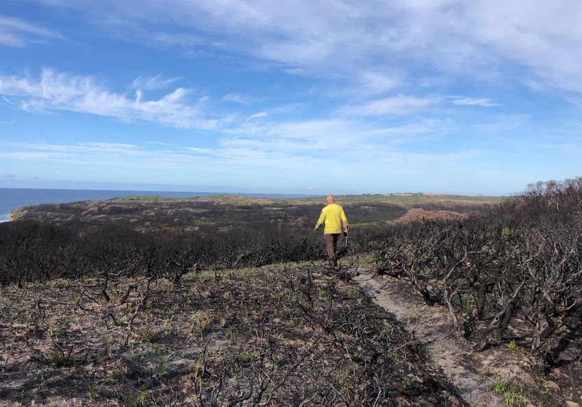
Table of Contents
Executive Summary                                    2
Introduction		                                       3
KBA Bushfire Recovery Actions                        5
Methodology 		                                       8
Effect of 2019/20 Bushfire Crisis on KBAs their
 Trigger Species and Priority Bird Species           10
Queensland		                                         11
   1. Palmgrove KBA                                  11
   2. Scenic Rim KBA                                 12
New South Wales                                      14
   3. Nightcap Range KBA                             14
   4. Gibraltar Range KBA                            15
   5. New England KBA                                17
   6. Werrikimbe KBA                                 19
   7. Greater Blue Mountains KBA                     20
   8. Capertee Valley KBA                            22
   9. Fitzroy Falls and associated hydrobasin KBA    24
   10. Jerrawangala KBA                              25
   11. Ulladulla to Merimbula KBA                    26

Victoria and NSW                                     27
   12. Australian Alps KBA                           27
   13. Nadgee to Mallacoota Inlet KBA                29
South Australia                                      31
   14. Kangaroo Island KBA                           31
Western Australia                                    33
   15.   Gillingarra KBA                             33
   16.   Araluen-Wungong KBA                         34
   17.   North Dandalup KBA                          35
   18.   Stirling Range KBA                          36
References		                                         37
Acknowledgements                                     38
Appendix		                                           39

Front cover image: Swamp Edge, Blue Mountains KBA,
image by Paul Vale

standing together to stop extinctions                1
Executive Summary
This report examines the 18 Key Biodiversity Areas (KBAs) which had 15% or
more of their habitat burnt by the unprecedented Bushfire Crisis that occured
in 2019/20. It provides a sobering account of the state of the areas that matter
most for plants, animals - and especially birds - in Australia. The report’s main
aim is to guide meaningful actions to facilitate the recovery of these KBAs. We
present the likely extent and severity of the burnt areas across each of the
KBAs in their entirety, as well as the impacts on regular sites for standardised
bird monitoring (Birdata Shared Sites). We specifically highlight impacts on the
bird Trigger species for KBAs and other bird species of national concern within
KBAs, as estimated by remote sensing/GIS. The report’s fire mapping is based
on National Indicative Aggregated Fire Extent Dataset v20200324 (NIAFED)
and NSW Government Google Earth Engine Burnt Area Map (GEEBAM) v3.1, as
available in April 2020. The assessment of the effect on birds is based on bird
surveys collected by BirdLife Australia volunteers, KBA Guardians and other
sources; and BirdLife Australia’s spatial analysis of population scale impacts on
bird species and subspecies (G. Ehmke pers. comm.).

  For all its doom and gloom, the report highlights the need for a differentiated
look at the on-ground situation, targeted surveys that quickly inform
conservation actions and a continuation of the spirit of collaboration and support
across the community highlighted so dramatically during the fire crisis. It is
thanks to the work of many volunteers and KBA Guardians that we can state the
most important finding of this report: ‘All that is burnt is not lost to the birds’.

Dedication
This report is dedicated to the brave women and men who risked - and some-
times gave - their lives fighting the 2019/20 fires to protect their communities
and the environment they cherish.

Citation
Todd, S. and Maurer, G. (2020). Bushfire recovery where it matters most.
Impacts and actions in Key Biodiversity Areas affected by the 2019/20 Bushfire
Crisis. BirdLife Australia, Melbourne.

ISBN: 978-1-875122-01-1

                                                            Cumberland trail, Australian
                                                            Alps KBA, image by Les Main

standing together to stop extinctions                                                 2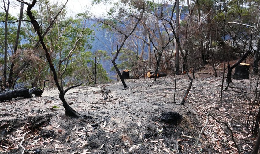
Introduction
The 2019/20 bushfire season was devastating for Australia’s wildlife and
unprecedented in its extent and severity. An estimated 31.5 million hectares
were burnt between 1 July 2019 to the 21 April 2020, disproportionately
affecting National Parks and Reserves destroying or drastically altering much
of species’ habitats specifically protected from urban, agricultural development
and forestry. The fires likely killed more than three billion native vertebrates
(Van Eeden and Dickman 2020) and the populations of almost 800 animal and
plant species. Many of them were considered secure before the fires, but have
been affected so severely that they have been declared Priority Species for
Commonwealth recovery efforts (Commonwealth of Australia 2020a).

  This report focuses on Key Biodiversity Areas (KBAs), the areas that are
critical to maintaining biodiversity in Australia, according to a rigorous,
internationally recognised, scientific standard www.keybiodiversityareas.org/
publications (IUCN 2016). With Australia being one of the world’s megadiverse
countries (Convention on Biological Diversity 2020) our KBA network contributes
disproportionally to the protection of global biodiversity.

  Key Biodiversity Areas (KBAs) are:

  •   Places of global signficance for the conservation of birds and other species
  •   Recognised as a focus for practical conservation action

  •   Linked to internationally binding agreements

  KBAs are identified using the strict, scientific Global Standard and
  must meet one of five criteria:
  •   Contain 0.5% of the population of a (critically) endangered species*
  •   Contain 10% of the population of a species* with a very small range
  •   Represent intact wilderness
  •   Provide important nurseries, migration bottlenecks etc. for one or more species*

  •   Be an irreplaceable part of a site network
  * known as KBA Trigger Species

  KBAs did not escape the fire catastrophe unscathed; over four million hectares
in 108 KBAs were affected by fires nationally in the summer of 2019/20, with
over two million hectares affected across 69 KBAs in the southern and eastern
states where bushfires were unprecedented in both severity and extent. Several
of these KBAs represent the last known sites for some Critically Endangered
Trigger Species e.g. crayfish and plants.
  Following on from a prolonged period of drought the fires were bad news
for birds too. KBAs are home to all 17 of the bird taxa (ten species and seven
subspecies) identified by the Australian Government’s Wildlife and threatened
species bushfire recovery Expert Panel (the Expert Panel) as a high priority for
urgent ‘urgent management intervention’. However, while many areas of habitat
within KBAs were burnt, KBAs also retained important unburnt refuges for these
species. Six of the most impacted species and subspecies have over 50% of their

standing together to stop extinctions                                                    3
remaining unburnt Area of Occupancy (AOO) in KBAs, and 14 have over 20%.
In particular, KBAs represent a disproportionately large area (85%) of unburnt
habitat for the Rufous Scrub-bird. Unburnt refuges are important for survival of
individuals during and immediately following fire, but they also play a larger role
in recolonisation as habitat recovers and are, therefore, of critical importance for
population recovery (Robinson et al. 2013).
This report marks the very beginning of understanding the consequences of the
fires for KBAs. It is clear, that on-ground monitoring is essential to gain a better
understanding of the level and nature of the impacts of bushfire on KBAs and the
birds and biodiversity they support. This information is vital to achieve effective
and efficient actions for recovery and preparedness.
Thanks to the dedication of many volunteers and the BirdLife Australia KBA
Guardian program, monitoring and recovery work can start from a solid base.
Most of the badly burnt KBAs have a KBA Guardian or Guardian group in place,
with strong relationships with local landholders and agencies and long-standing,
regular, standardised bird survey sites. The many years of bird monitoring data—
available in birdata.birdlife.org.au—are proving invaluable for the assessment
of the impacts of fire as they enable a comparison of bird populations pre– and
post-fire. For instance, some of the most reliable survey sites for the Rufous
Scrub-bird escaped the fires and have retained their birds. Such findings
highlight that the burnt KBAs and other fire affected areas have by no means
lost their value to Australia’s biodiversity. On the contrary, their importance to
our wildlife has only grown.
In response to the bushfire crisis, every effort must be made to reduce any
additional pressures on these sites and the species they support. Calls to revoke
environmental protections to allow for logging and other detrimental activities
are thus not only cynical but ill informed. In fact, the KBA Guardians contributing
to this work through their local knowledge and tireless volunteering have stated
this very clearly:
All that is burnt is not lost to the birds
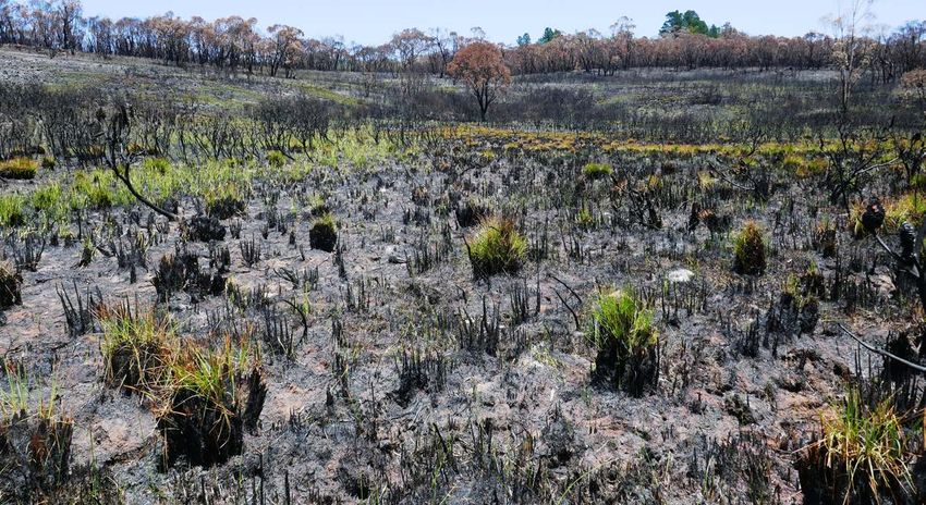
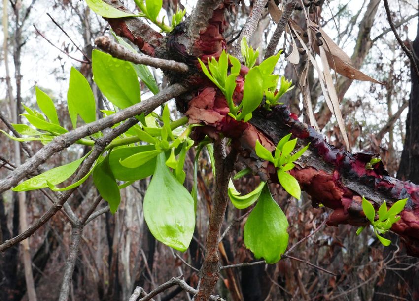
Re-sprouting of a burnt
Persoonia, Blue Mountains
KBA, image by Paul Vale
standing together to stop extinctions 4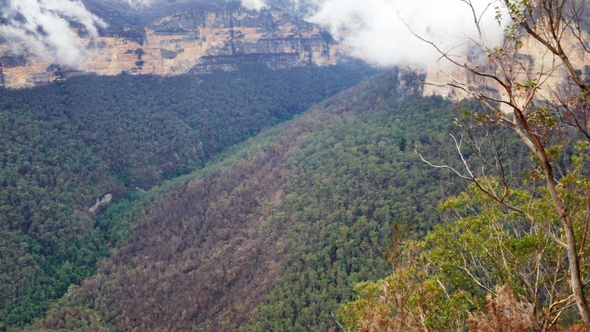
KBA Bushfire Recovery Actions
The speed and success of the bushfire recovery depends on focussing scarce
resources towards the most appropriate actions in the right places. We have
identified the following priority actions for KBA Guardians and other volunteers
to implement and support this process:

    •    Standardised surveys at existing Birdata Shared Sites as KBAs become
         safe to access. The Birdata app and website now highlight fire affected
         sites in red.

    •    Standardised Birdata surveys at new sites as KBAs become safe to access;
         where appropriate, these should be set up as Shared Sites for long-term
         monitoring.

    •    Incidental reports to Birdata of Priority Species (see Appendix Table2).

    •    Collecting fire impact information using the new Birdata function.

    •    Several fire affected KBAs do not currently have Guardians. For these
         KBAs, Guardians are needed to lead the postfire monitoring and recovery.

    •    Conducting the Easter Health-checks for these KBAs will require liaison
         with landholders and agency staff to obtain an accurate picture of fire
         impacts and unusual bird sightings.

    •    Liaison with ‘Friends’ groups and experts on Trigger Species, Priority
         Birds and other taxa are necessary to learn what additional important
         information should be gathered during visits, e.g. the state of creeks used
         by rare crayfish.

    •    Assess the addition of KBA Trigger Species resulting from changes of IUCN
         threat status in response to fire.

    •    Assess the need to change KBA boundaries or propose new KBAs to
         accommodate new KBA Trigger Species. Mud maps and local knowledge
         will be invaluable for this work.

Selecting of post-fire survey methodology and sites
Post-fire surveys to assess bird survival and habitat use will enable a comparison
with pre-fire distribution data, thereby providing a valuable focus and refinement
for on-ground conservation action. Surveys will be most valuable when
conducted using standardised methodology. Four concepts are central to site
selection and survey design in KBAs:

1. Shared Sites
   A defined location for a Standardised Survey (published on Birdata) to assist
   repeat surveys by multiple observers. These sites are shown on the maps
   below and can be found on the Birdata app and website https://birdata.
   birdlife.org.au/shared-sites

2. Standardised Surveys
   The recommended survey method is usually either a 2ha-20min survey or
   500m-radius area search as per BirdLife (Birdata.birdlife.org.au/survey-
   techniques). Every Shared Site comes with Standardised Survey methods to
   be used when surveying that Site. However, where a specific targeted survey

standing together to stop extinctions                                               5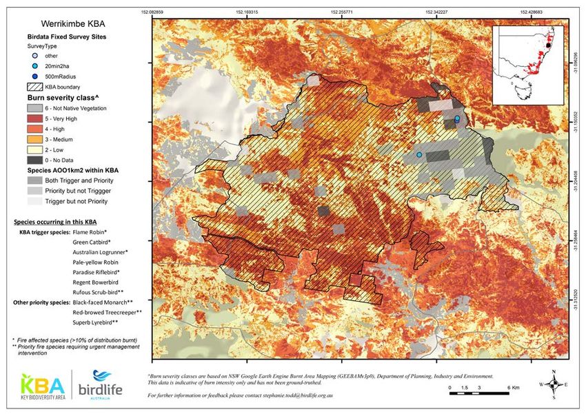
methodology has been used to monitor a Trigger Species in the past, that
    method takes precedence, e.g. targeted surveys for Rufous Scrub-birds.

3. Clusters
   A larger area where multiple actual or potential Shared Sites are located
   in convenient proximity to each other so that Standardised Surveys can be
   conducted at each of them during a single visit to the Cluster.

4. Trigger Species
   KBA Trigger Species are those species for which the KBA was declared. These
   species meet at least one of the criteria; based on the IUCN Red List or
   endemism, as defined in the KBA Standard (IUCN 2016).

Survey sites for post fire KBA monitoring should be selected to:

    •    Continue an existing series of surveys by targeting Birdata Shared Sites.
    •    Facilitate comparison between sites that have experienced different fire
         severity by pairing Shared Sites in the same Cluster or, failing that, in the
         same KBA

    •    Inform the assessment of Trigger Species and Priority Species populations
         by choosing sites where they have occurred in the past

    •    Increase the power of future analyses by surveying Shared Sites paired
         based on their difference in burn severity in as many Clusters as possible

                                                               1 month post-burn

                                                              3 months post-burn

                   Yans Firetrail, Kosciuszko NP, Australian Alps KBA “These images
                   were taken 2 months apart show a far cooler fire [...]” Les Main,
                   Australian Alps KBA Guardian. Image by Les Main.

standing together to stop extinctions                                                  6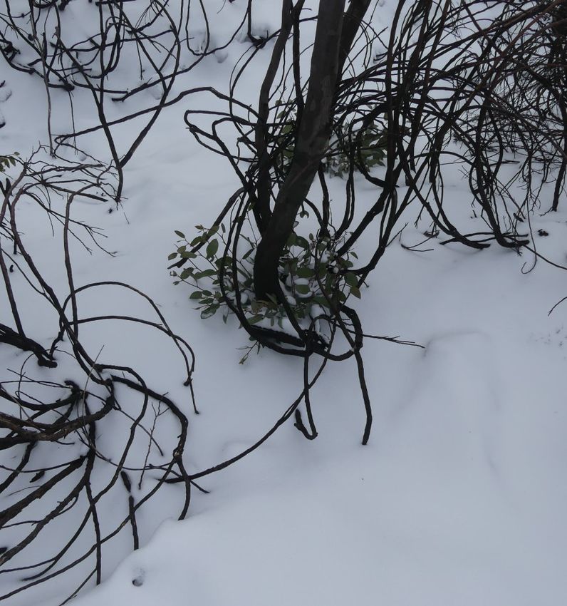
THE FOLLOWING KEY IS DESIGNED TO HELP WITH SELEC TING SITES

                                                          Start
Contact kba@birdlife.org.au
to set up a Shared Site           N     Is there a Birdata Shared Site in KBA?
                                                            Y

                                        Is the Shared Site accessible and safe?

                                                            Y
            N

                                        > 2 surveys since 2010 with Trigger or
                                        Priority birds recorded?                          N     Is there another Shared Site?

                                                            Y                                                 N

Can Site be paired with Site
                                        Can Site be paired with Site in similar
in similar habitat but
                                   N    habitat but different fire severity in                   Contact kba@birdlife.org.au
different fire severity
                                        same Cluster?                                            to set up a Shared Site
elsewhere in KBA?
             Y                                              Y

Survey maximum # of paired                   Are there multiple accessible                    Survey maximum # of paired
                                                                                  N
Shared Sites in the one KBA                  Clusters in KBA?                                 Shared Sites in the one Cluster

                                                            Y

                      Choose one pair of Sites fire severity in each Cluster as follows

                                                                         Do Site pairs in                    Survey most
                      Do pairs of Sites in each Cluster
                                                                  N      cluster vary in fire          N     convenient
                      differ in # of Trigger species?
                                                                         severity difference?                Site pair
                                        Y                                             Y

                        Survey the Site pair with                        Survey the Sites pair with greatest
                        most Trigger species in as                       difference in fire severity as per
                        many Clusters as possible                        maps in this report

     standing together to stop extinctions                                                                          7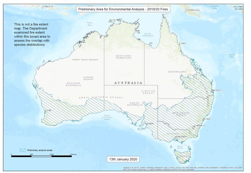
Methodology
Fire Extent
The Area affected within each KBA was calculated by overlapping KBA
boundaries with the National Indicative Aggregated Fire Extent Dataset
v20200324 (NIAFED). This is an amalgamation of data from the Rural Fire
Service (RFS), state agency and satellite imagery. It is also known as the fire
footprint, and is generally larger than the actual burnt area, as it includes all
areas affected by fire, including spot fires, patchy burns and unburnt areas.

Burn Severity Mapping
All burn severity mapping was based on the differential Normalised Burn Ratio
(dNBR), an index that can be calculated from changes in vegetation reflectance
detected by satellite imagery. In this case, Sentinel2 multispectral satellite data
were used, with a spatial resolution of 10m.

 For KBAs in NSW, the severity mapping from the NSW Government Google
Earth Engine Burnt Area Map (GEEBAM), v3.1 was used. This dataset groups
burn severity into four classes: Low, Medium, High or Very High.
  For each KBA in NSW, two additional statistics were calculated from GEEBAM:
       ‘Area burnt’ - the area sum of burn classes ‘Medium’ to ‘Very High’. Class
       ‘Low’ was excluded from this metric because earlier severity mapping
       showed these areas had remained largely unchanged, and this metric is
       designed to give a more conservative estimate of burnt area than NIAFED.

       ‘Area badly burnt’ - the sum of burn classes ‘High’ to ‘Very High’,
       indicating areas where the canopy is likely to have been partially or fully
       affected

  Where state agency maps were unavailable, burn severity maps were
generated in Google Earth Engine using a similar approach to GEEBAM (Gorelick
et al. 2017). Further details and code can be provided on request. Due to the
difficulty of accurately thresholding ecologically meaningful burn classes from
raw dNBR values across diverse environments, these maps were used for
visualisation only, and no statistics were calculated from them.

Birdata Shared Sites
The burn status of Birdata Shared Sites was also calculated by overlaying the
NIAFED polygons. These include ‘20min-2ha’ and ‘500m-radius area search’
standard surveys sites. Sites were considered to be affected/burnt if the area of
overlap was nonzero, that is any part of the site was affected.

Fire Affect Bird Species
Area of Occupancy (AOO) of the 121 species of birds that have been assessed
by BirdLife Australia for spatial overlap with fire footprint (G. Ehmke 2020 pers.
comm.) were overlayed with KBAs to investigate the possible extent of the
impact of fire on Trigger and other Priority Species within each KBA. The AOO
of both Trigger and other Priority Species is displayed on each KBA map. For
the purposes of this report, ‘fire affected’ species have more than 10% of their
distribution burnt, according to at least one of two fire metrics:

standing together to stop extinctions                                                8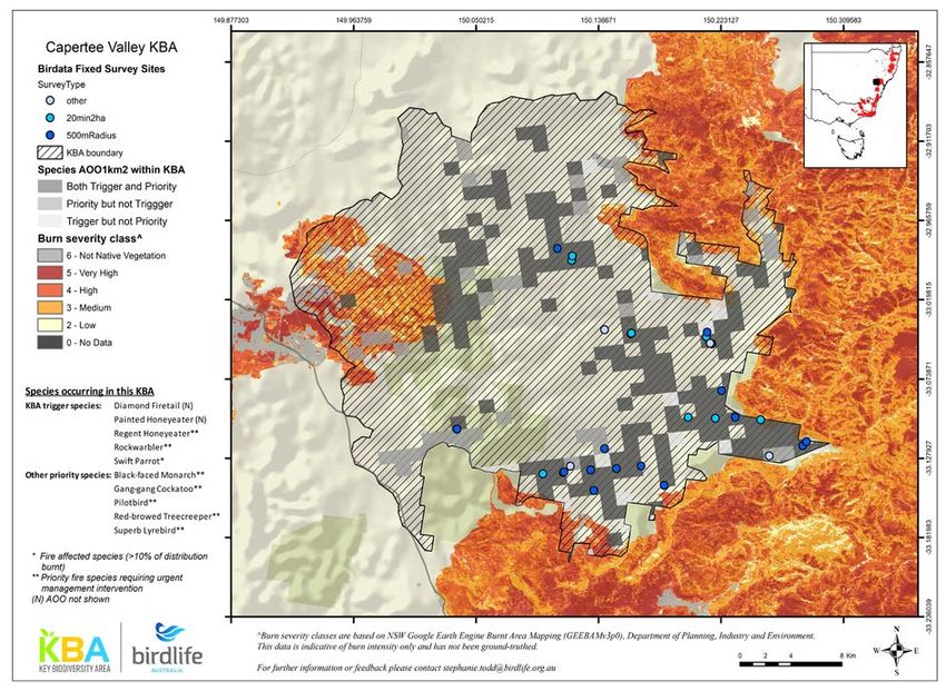
-    AOO based on a 1-km grid (each grid cell counted as burnt if >50% of the
         cell overlaps fire footprint)

    -    Extent of Occurrence (EOO) based on subsetted minimum convex
         polygons, for core, seasonal and breeding parts of the species’ range.

  As KBAs are home to many of these fire affected species, they are critical for
post-fire recovery and may provide important unburnt refuges. The relative
importance of KBAs as refuges for fire-affected species was calculated as the
proportion of total unburnt AOO for each species that falls within KBAs (see
Appendix).
  ‘Priority Species’ are those determined to be most impacted by the 2019/20
fires as assessed by the Expert Panel. These birds and Priority Species in other
taxonomic groups comprise the ‘Revised provisional list of animals requiring
urgent management intervention’, published by the Commonwealth Government
(Legge et al. 2020). The list contains 17 Priority Species of bird, which can be
found here (www.environment.gov.au/biodiversity/bushfire-recovery/priority-
animals), along with further details on the assessment methodology.

Report Coverage
KBAs with 15% or more of their area overlapped by NIAFED have been
included in this report. Only KBAs in the southern and eastern parts of Australia
were considered, that are within the ‘Preliminary analysis area map’, below
(Commonwealth of Australia 2020b).

standing together to stop extinctions                                             9
Effect of 2019/20 Bushfire Crisis on KBAs, their
Trigger Species and Priority Bird Species
This section provides an overview of the 18 KBAs outside the Northern Savanna
area of Australia that had 15% or more of their habitat affected by fires in the
catastrophic 2019/20 bushfire season. The KBAs are listed by state and then
from north to south in each state. Each KBA account provides a site description
based on BirdLife Australia’s 2009 site nominations (available on datazone.
birdlife.org/site); a map showing the fire extent and Birdata Shared Sites; key
statistics about the fire extent in the KBA; a list of current KBA Trigger Species
and, where available, the extent habitat burnt measured as Area of Occupancy
(AOO) for species of conservation concern within each KBA. At the available
scale and resolution the maps are necessarily coarse and for orientation rather
than navigation. More detailed electronic maps or sections of them can be
requested from kba@birdlife.org.au. Further, the Shared Sites can be accessed
at Birdata.birdlife.org.au/shared-sites#map, which also provides an indication of
their fire status.
Evans Lookout, Blue Mountains KBA,
image by Paul Vale
standing together to stop extinctions 10Queensland
1. Palmgrove KBA
Site description
The KBA is identical to Palmgrove National Park (Scientific), which is located
approximately 185 km north-north-east of Roma in south-central Queensland.
This KBA is designated on the basis of more than 10 pairs of Black-breasted
Button-quail in a significant location - this is the western-most population,
isolated from all other populations, and although numbers of this species are
poorly-known, there are large tracts of suitable habitat. Palmgrove is situated
in moderately dry, dissected sandstone country. The vegetation is moderately
diverse, hosting a variety of eucalypt woodland and forest types as well as vine
thicket and acacia thicket communities. These thickets, which comprise the
habitat of the Black-breasted Button-quail, occur in very small pockets in other
nearby protected areas and State Forests, all of which have been logged, and
are not known to support populations of the button-quail.
Fire extent
Key Statistics
KBA area 25,188 ha
Area affected 13,864 ha (55%)
No shared monitoring sites
Trigger Species: Black-breasted Buttonquail. AOO burnt for this Trigger Species in
Palmgrove has not been analysed because of scarcity of recent data.
standing together to stop extinctions 112. Scenic Rim KBA Site description This KBA consists of a series of contiguous protected areas along the Queensland / New South Wales border. It is defined as the following protected areas, which support populations of threatened species: Main Range National Park, Glen Rock Regional Park, Mount Barney National Park, Mount Chinghee National Park, Lamington National Park, Springbrook National Park, Border Ranges National Park, Koreelah National Park, Mebbin National Park, Wollumbin National Park, Mount Clunie National Park, Mount Nothofagus National Park, Wollumbin National Park, State Conservation Area, Limpinwood Nature Reserve and Numinbah Nature Reserve. The KBA also includes private properties which support the Eastern Bristlebird but these are not displayed on the map. Additional contiguous areas of forest could be included in the KBA but are not known to support populations of the threatened species. The whole Scenic Rim is largely volcanic in origin, including the Mt Warning Shield volcano, Focal Peak volcanics and Main Range volcanics. Other areas are of sedimentary origin including parts of eastern Lamington area and parts of Mount Barney National Park. The now deeply weathered, mainly basaltic soils, which dominate the KBA, support a number of rainforest/vine thicket ecosystems as well as some rare grassland and eucalypt communities. The area has a coastal sub-tropical climate with average maximum summer temperatures of 29 °C, average minimum winter temperatures of 6 °C and average annual rainfall of 1555 mm at the lowest altitudes (data sourced from Tyalgum weather station altitude 55 metres). Parts of Wollumbin NP, Border Ranges NP, Limpinwood NR, Numinbah NR, 20,000 ha of Lamington NP and a portion of Mebbin NP are listed as a World Heritage site, and most of Border Ranges NP and all of Limpinwood NR are designated as Wilderness Areas. Fire extent standing together to stop extinctions 12
Key Statistics

 KBA area                                   138,357 ha
 Area affected                               49,459 ha           (36%)
 Area burnt (NSW)                             9,080 ha           (7%)
 Area badly burnt (NSW)                       3,088 ha           (2%)
 GEEBAMv3p1_footprint_coverage                9,227 ha           (19%)
 Shared monitoring sites                10(15)/70 sites burnt

Trigger Species: Black-breasted Buttonquail, Albert’s Lyrebird, Rufous Scrub-
bird, Green Catbird, Regent Bowerbird, Eastern Bristlebird, Australian Logrunner,
Paradise Riflebird, Pale-yellow Robin

                                                                AOO sqkm   % AOO burnt

 KBA Trigger Species, Commonwealth Priority and
  BirdLife Concern
 Albert’s Lyrebird                                                233          23
 Eastern Bristlebird                                               25          26
 Rufous Scrub-bird                                                 67          8

 KBA Trigger Species of BirdLife concern
 Australian Logrunner                                             134          19
 Green Catbird                                                    169          23
 Pale-yellow Robin                                                 91          16
 Paradise Riflebird                                               137          22

 Not KBA Trigger Species but a Commonwealth Priority
 Black-faced Monarch                                              183          27
 Red-browed Treecreeper                                            60          37
 Regent Honeyeater                                                 3           0
 Superb Lyrebird                                                   7           27

standing together to stop extinctions                                               13
New South Wales 3. Nightcap Range KBA Site Description The Nightcap Range KBA consists of four protected areas in north-east New South Wales: Nightcap, Goonengerry and Mount Jerusalem National Parks, and Whian Whian State Conservation Area. The Nightcap Range KBA is located in very close proximity to the Scenic Rim KBA, which lies 10 km to the north- west, but is kept separate because it is located at a lower altitude and supports a slightly different suite of birds. Neighbouring forests could be added to the Nightcap Range KBA if the populations of Albert’s Lyrebirds in these forests are considered to be of global significance. The KBA receives the highest volume of annual rainfall of any region in NSW (average 2351 mm per year at 380 m altitude, higher at higher altitudes); average summer temperatures are 17-27 °C and winter temperatures 7-17 °C at this altitude. Warm temperate rainforest is found throughout the park on soils with a rhyolitic base, while subtropical rainforest is supported by nutrient-rich basalt soils. Sixty-one percent of the KBA (or the extent of Nightcap NP in 1994) is included in the Gondwana Rainforests of Australia World Heritage Area. Fire extent standing together to stop extinctions 14
Key Statistics

 KBA area                               16,104 ha
 Area affected                          5,236 ha           (33%)
 Area burnt (NSW)                       4,986 ha           (31%)
 Area badly burnt (NSW)                 1,037 ha           (6%)
 GEEBAMv3p1_footprint_coverage          5,058 ha           (97%)
 Shared monitoring sites                4/16 sites burnt

Trigger Species: Albert’s Lyrebird, Green Catbird, Regent Bowerbird, Logrunner,
Paradise Riflebird, Pale-yellow Robin

                                                            AOO sqkm   % AOO burnt
 KBA Trigger Species, Commonwealth Priority and
  BirdLife Concern
 Albert’s Lyrebird                                                66       33

 KBA Trigger Species of BirdLife concern
 Australian Logrunner                                             27       25
 Green Catbird                                                    20       27
 Pale-yellow Robin                                                25       23
 Paradise Riflebird                                               26       32

 Not KBA Trigger Species but a Commonwealth Priority
 Black-faced Monarch                                              15       26
 Eastern Bristlebird                                               2       0
 Red-browed Treecreeper                                            3       31
 Regent Honeyeater                                                 0       0
 Superb Lyrebird                                                   0       0

4. Gibraltar Range KBA

Site Description

The Gibraltar Range KBA comprises Gibraltar Range and Barool National Parks,
located between Glen Innes and Grafton in northern New South Wales. These
protected areas support all suitable high-altitude rainforest in the range of
a population of Rufous Scrub-birds. Parts of these national parks have been
declared Wilderness Areas and are included in the World Heritage Gondwana
Rainforests of Australia. The average winter daytime temperature is 13 °C, the
average summer daytime temperature is 25 °C and rainfall peaks at over 2000
mm on the highest peaks. The area is one of the highest ridges of the Great
Dividing Range and supports many ecosystems including warm-temperate
rainforest, sclerophyll forest, heathlands and the largest remaining area of
coachwood-dominated warm temperate rainforest in the world. Dominant land
forms include high ridges and plateaux, the Great Eastern Escarpment, steep
sided valleys, creeks, waterfalls, granitic rock formations and outcrops. The
adjacent Washpool and Nymboida National Parks could be included in the KBA
but neither is believed to currently support Rufous Scrub-birds.

standing together to stop extinctions                                            15
Fire extent
Key statistics
KBA area 36,563 ha
Area affected 32,629 ha (89%)
Area burnt 30,741 ha (84%)
Area badly burnt 14,316 ha (39%)
Shared monitoring sites 4/4 sites burnt
Trigger Species: Rufous Scrub-bird, Green Catbird, Logrunner, Paradise Riflebird,
Pale-yellow Robin
Gibraltar Range KBA,
image by Keith Fisher
standing together to stop extinctions 16AOO sqkm % AOO burnt KBA Trigger Species, Commonwealth Priority and BirdLife Concern Rufous Scrub-bird 16 100 KBA Trigger Species of BirdLife concern Australian Logrunner 17 77 Green Catbird 13 78 Pale-yellow Robin 10 90 Paradise Riflebird 3 100 Not KBA Trigger Species but a Commonwealth Priority Albert’s Lyrebird 1 100 Black-faced Monarch 21 90 Red-browed Treecreeper 17 94 Superb Lyrebird 34 85 Blackheath area of Blue Mountains National Park & nearby Council Reserves, showing before the fires (Jan 2019, left) and after fires (Jan 2020, right). Images by Paul Vale 5. New England KBA Site description The KBA is identical to New England National Park, which is located 75 km east of Armidale and 50 km west of Coffs Harbour in New South Wales. The park includes the high eastern escarpment of the Great Dividing Range and consists of high cliffs, rugged ridges and streams which converge into two main river systems, the Bellinger and the Macleay. Average annual rainfall is 1514 mm at a station at 1060 m altitude, average maximum summer temperatures here are 24 °C and minimum winter temperatures are 2 °C. Palaeozoic sedimentry and metamorphic rocks of slate, phylitte and greywake dominate the landscape, and on the plateau these are covered by the volcanic basalt, trachyte and tuff. These different rock types produce very different soils which, along with the high altitudinal range, support a diversity of flora and fauna. The park plays host to around 60,000 visitors a year and has walking tracks, camping grounds and other facilities to accommodate them. New England National Park is World Heritage listed and has a substantial area that fits the criteria for a Wilderness Park. This area stretches through the rugged gullies and ridges of the Bellinger River and Five Day Creek. standing together to stop extinctions 17
Fire extent

Key Statistics
 KBA area                               74,583 ha
 Area affected                          38,365 ha         (51%)
 Area burnt                             36,787 ha         (49%)
 Area badly burnt                       8,543 ha          (11%)
 Shared monitoring sites                0/5 sites burnt

Trigger Species: Rufous Scrub-bird, Green Catbird, Regent Bowerbird, Logrunner,
Paradise Riflebird, Pale-yellow Robin, Flame Robin

                                                                  AOO sqkm   % AOO burnt
 KBA Trigger Species, Commonwealth Priority and
   BirdLife Concern
 Rufous Scrub-bird                                                   27          10
 KBA Trigger Species of BirdLife concern
 Australian Logrunner                                                27          38
 Flame Robin                                                         12          16
 Green Catbird                                                       21          32
 Pale-yellow Robin                                                   14          28
 Paradise Riflebird                                                  16          24
 Not KBA Trigger Species but a Commonwealth Priority
 Black-faced Monarch                                                 29          32
 Red-browed Treecreeper                                              16          32
 Superb Lyrebird                                                     47          30

standing together to stop extinctions                                                 18
6. Werrikimbe KBA Site Description The KBA is identical to Werrikimbe National Park, which is located in the Great Dividing Range of New South Wales, 70 km inland of Port Macquarie. The national park is located within a contiguous series of protected areas, and all of the key bird species occur more widely with the exception of the Rufous Scrub- bird, which is restricted to Werrikimbe. The parks are located in a region which receives substantial rainfall (average 1655 mm per year at 155 m altitude, much higher at high altitudes); average summer temperatures are 27-28 °C and winter temperatures 6-18 °C at this altitude. The park is situated on the eastern escarpment of the Great Dividing Range and represents rugged wilderness, with two major rivers, the Forbes and the Hastings. The vegetation is dominated by sub-tropical and cool temperate rainforests, and tall eucalypt forests with significant areas of Antarctic Beech used by Rufous Scrub-birds. When under the former State Forest tenure, some areas of the park were selectively logged for cedar and tallowwood, with some areas clear felled. The National Park rainforests are included in the Gondwana Rainforests of Australia World Heritage Area and some of the park is declared as wilderness area(s). The KBA could be extended to include the adjacent Mt Boss State Forest, which has previously supported small numbers of Rufous Scrub-birds. Fire extent standing together to stop extinctions 19
Key statistics

 KBA area                        35,127 ha
 Area affected                   35,127 ha         (100%)
Area burnt                       31,275 ha         (89%)
Area badly burnt                 14,960 ha         (43%)
Shared monitoring sites          3/3 sites burnt

Trigger Species: Rufous Scrub-bird, Green Catbird, Regent Bowerbird, Logrunner,
Paradise Riflebird, Pale-yellow Robin, Flame Robin

                                                            AOO sqkm   % AOO burnt

 KBA Trigger Species, Commonwealth Priority and
   BirdLife Concern
 Rufous Scrub-bird                                             19         100

 KBA Trigger Species of BirdLife concern
 Australian Logrunner                                          17         100
 Flame Robin                                                   13         100
 Green Catbird                                                 6          100
 Pale-yellow Robin                                             2          100
 Paradise Riflebird                                            6          100

 Not KBA Trigger Species but a Commonwealth Priority
 Black-faced Monarch                                           21         100
 Red-browed Treecreeper                                        10         100
 Superb Lyrebird                                               29         100

7. Greater Blue Mountains KBA
Site Description

The KBA includes the whole Greater Blue Mountains World Heritage Area which
is comprised of eight protected areas: Blue Mountains, Kanangra-Boyd, Gardens
of Stone, Wollemi, Nattai, Yengo and Thirlmere Lakes National Parks and the
Jenolan Karst Conservation Reserve. This area includes most of the Hawkesbury
Sandstone massif 60 to 180 km inland of Sydney, which supports most of the
world population of the Rock Warbler. Another 12 adjacent protected areas could
be included but the World Heritage Area supports a sustainable population of
Rock Warblers. A number of peripheral valleys supporting Regent Honeyeaters
and other woodland birds could be considered for inclusion within this KBA
or as separate KBAs: the Capertee and Burragorang valleys are categorised
as separate KBAs but the Howes Valley in the Wollemi National Park has not
supported significant numbers of Regent Honeyeaters since 1994. Within the
World Heritage Area, 542,000 ha has been designated as Wilderness Areas, and
another 245,000 ha could be listed. The area is dominated by eucalypt forest
between rugged sandstone cliffs, with an exceptional diversity of habitats.
Because of the intrinsic beauty, natural features and accessibility from the major
population centres, the area has high recreational values, and hosts more than
three million visitors annually.

standing together to stop extinctions                                           20
Fire extent Evans Lookout, Blue Mountains KBA, image by Paul Vale standing together to stop extinctions 21
Key statistics

 KBA area                          1,074,505 ha
 Area affected                     897,882 ha        (84%)
 Area burnt                        857,231 ha        (80%)
 Area badly burnt                  484,635 ha        (45%)
 Shared monitoring sites           28(29)/87 sites
                                   burnt

Trigger Species: Yellow-faced Honeyeater, Regent Honeyeater, Pilotbird, Rock-
warbler, Flame Robin, Diamond Firetail

                                                             AOO sqkm   % AOO burnt

 KBA Trigger Species, Commonwealth Priority and
   BirdLife Concern
 Pilotbird                                                     204          76
 Regent Honeyeater                                              52          78
 Rockwarbler                                                   414          74

 KBA Trigger Species of BirdLife concern
 Flame Robin                                                    78          68
 Yellow-faced Honeyeater                                       1261         78

 Not KBA Trigger Species but a Commonwealth Priority
 Black-faced Monarch                                           206          80
 Gang-gang Cockatoo                                            528          85
 Red-browed Treecreeper                                        293          84
 Superb Lyrebird                                               954          79

8. Capertee Valley KBA
Site Description

The KBA consists of the entire Capertee Valley, a distinct ecological region
surrounded by granitic hills and sedimentary plateaux, located about 45 km
north of Lithgow in central-eastern New South Wales. The KBA is defined by
the boundary of the Capertee Valley IBRA sub-region to the west and the
Blue Mountains & Wollemi KBA to the east. Capertee Valley has a temperate
climate characterised by warm, dry summers and cool, damp winters; mean
temperatures (minimum-maximum) vary from 2-15 °C (June) to 16-30 °C
(January) and mean annual rainfall is 634 mm at Glen Davis. The valley is
extensively cleared for cattle grazing with remnant woodland patches on low
rolling hills, and is surrounded by timbered scree slopes and sandstone cliffs on
the western side of the Blue Mountains & Wollemi National Parks and KBA. The
remnant native vegetation of the valley consists mostly of dry sclerophyll forest
and grassy woodland with smaller stands of wet sclerophyll forest and some
patches of montane heath. Changes to land use in recent years have resulted in
an increase in the extent of natural regrowth and revegetation by landholders.

standing together to stop extinctions                                            22
Fire extent
Key statistics
KBA area 71,627 ha
Area affected 11,990 ha (17%)
Area burnt 10,269 ha (14%)
Area badly burnt 5,304 ha (7%)
Shared monitoring sites 7(9)/39 sites burnt
Trigger Species: Swift Parrot, Regent Honeyeater, Painted Honeyeater,
Rockwarbler, Diamond Firetail
AOO sqkm % AOO burnt
KBA Trigger Species, Commonwealth Priority and
BirdLife Concern
Rockwarbler 135 7
Regent Honeyeater 28 20
KBA Trigger Species of BirdLife concern
Swift Parrot 25 5
Not KBA Trigger Species but a Commonwealth Priority
Black-faced Monarch 1 0
Gang-gang Cockatoo 57 7
Pilotbird 1 0
Red-browed Treecreeper 25 9
Superb Lyrebird 44 20
standing together to stop extinctions 239. Fitzroy Falls and associated hydrobasin KBA
Site Description
This KBA is based on an Alliance of Zero Extinction site triggered by Euastacus
dharawalus. The entire known population of this species is confined to this site.
KBA boundaries are based on the hydrobasin.
Fire extent
Key Statistics
KBA area 12,395 ha
Area affected 7,817 ha (63%)
Area burnt 6,440 ha (52%)
Area badly burnt 5,208 ha (42%)
Shared monitoring sites 0/4 sites burnt
Trigger Species: Euastacus dharawalus (freshwater crayfish)
AOO sqkm % AOO burnt
Not KBA Trigger Species but a Commonwealth Priority
Black-faced Monarch 9 31
Eastern Bristlebird 1 0
Gang-gang Cockatoo 8 57
Pilotbird 4 27
Red-browed Treecreeper 3 0
Regent Honeyeater 1 100
Rockwarbler 7 47
Superb Lyrebird 17 55
standing together to stop extinctions 2410. Jerrawangala KBA
Site Description
This KBA is based on an Alliance of Zero Extinction site triggered by Euastacus
guwinus. Entire known population confined to this site. The KBA boundary is
based on Jerrawangala National park boundary.
Fire extent
Key statistics
KBA area 4,024 ha
Area affected 4,024 ha (100%)
Area burnt 3,980 ha (99%)
Area badly burnt 3,382 ha (84%)
No shared sites present
Trigger Species: Euastacus guwinus (freshwater crayfish)
AOO sqkm % AOO burnt
Not KBA Trigger Species but a Commonwealth Priority
Black-faced Monarch 1 100
Gang-gang Cockatoo 3 100
Pilotbird 1 100
Rockwarbler 2 100
Superb Lyrebird 4 100
standing together to stop extinctions 2511. Ulladulla to Merimbula KBA Site Description This KBA is defined for Spotted Gum and other flowering eucalypts used by Swift Parrots. The current KBA boundary is approximate based largely on surveys in 2009 that recorded Swift Parrots in Spotted Gum forests between Ulladulla and Merimbula. The KBA boundary follows the estimated extent of Spotted Gum forests, extending about 10 km inland of the coast between Ulladulla and Merimbula, but further surveys are needed to refine the boundary, particularly its inland (western) extent. The KBA also includes forests dominated by a range of other eucalypts, of which various ironbarks and bloodwoods are likely to support Swift Parrots in years in which the Spotted Gums are not flowering. The KBA also includes large areas of cattle-grazed pasture between forest blocks, and small areas of urban development and agriculture. These artificial habitats are likely to be of some value to Swift Parrots which utilise scattered large flowering trees and small remnants of native vegetation in otherwise modified landscapes. Fire extent standing together to stop extinctions 26
Key statistics

 KBA area                                217,832
 Area affected                           76,621            (35%)
 Area burnt (NSW)                        64,920            (30%)
 Area badly burnt (NSW)                  43,261            (20%)
 Shared monitoring sites          27(34)/139 sites burnt

Trigger Species: Swift Parrot

                                                             AOO sqkm    % AOO burnt
 KBA Trigger Species of BirdLife concern
 Swift Parrot                                                      127       33

 Not KBA Trigger Species but a Commonwealth
  Priority
 Black-faced Monarch                                               202       31
 Eastern Bristlebird                                                0        0
 Gang-gang Cockatoo                                                209       29
 Pilotbird                                                         34        18
 Red-browed Treecreeper                                            43        37
 Regent Honeyeater                                                 20        15
 Superb Lyrebird                                                   270       41

Victoria and NSW
12. Australian Alps KBA
Site description

The KBA consists of Kosciuszko and Namadgi National Parks in south-eastern
New South Wales and Alpine National Park in eastern Victoria. Situated within
the Great Dividing Range, the three parks captured by the KBA encompass
a sizeable and representative proportion of Australia’s alpine and sub-alpine
regions, which support large breeding populations of the near threatened
Flame Robin and restricted-range Pilotbird. A number of contiguous protected
areas such as Brindibella National Park, Bimberi Nature Reserve, Tidbinbilla
Nature Reserve and Scabby Range Nature Reserve in New South Wales and
Avon Wilderness Park and Snowy River National Park are currently omitted
from the KBA, but could qualify for inclusion pending further investigation.
The mountainous terrain of the KBA is dominated by eucalypt woodlands and
forests, with various types of woodland and dry sclerophyll forest on lower
slopes, tall wet sclerophyll or montane forest of Alpine Ash and other species
at intermediate elevations and open Snow Gum woodlands in the subalpine
zone. At the highest altitudes, the terrain is exposed and devoid of trees, with
the forests and woodlands of the lower zones replaced by a mixture of alpine
herbfields, grasslands, heathlands and moss communities. Other vegetation
communities occur in the KBA but are limited in extent, e.g. pockets of cool
temperate rainforest grow in some mountain gullies. Climatic conditions vary
throughout the KBA, with precipitation increasing and temperature decreasing
with altitude. Severe weather can occur in alpine regions, which are prone

standing together to stop extinctions                                              27
to sub-zero temperatures, frosts, rain- and snowfall and high winds. Snow is
typically present in high-altitude areas for several months of the year.
Fire extent
A section of the Australian Alps KBA, months after the fires went through. “It burnt in
January and I am yet to see a bird in this area since it burnt.” Denise Allardice, KBA
Guardian. Image by Denise Allardice
standing together to stop extinctions 28Key Statistics
KBA area 1,470,823
Area affected 468,789 ha (32%)
Area burnt 238,005 ha (16%)
Area badly burnt 175,979 ha (12%)
GEEBAMv3p1_footprint_coverage 242,893 ha (52%)
Shared monitoring sites 88(95)/144 sites burnt
Trigger Species: Pilotbird, Flame Robin
AOO sqkm % AOO burnt
KBA Trigger Species, Commonwealth Priority and
BirdLife Concern
Pilotbird 96 25
KBA Trigger Species of BirdLife concern
Flame Robin 639 35
Not KBA Trigger Species but a Commonwealth
Priority
Gang-gang Cockatoo 447 42
Red-browed Treecreeper 111 42
Regent Honeyeater 1 0
Superb Lyrebird 321 41
13. Nadgee to Mallacoota Inlet KBA
Site description
This KBA includes all of Nadgee National Park in NSW and the eastern section
of the 87,500 ha Croajingolong National Park in Victoria. The key bird species,
Eastern Bristlebird, is no longer found west of Mallacoota inlet in Victoria
so this section of Croajingolong is excluded. The habitat is largely a patchy
mosaic of coastal heath and eucalypt woodlands. This includes Nadgee Coastal
Heath Complex and Nadgee Coastal Heath/Woodland, which occurs in exposed
situations along the coast. There is a diverse range of structurally complex wet
heath, mainly occurring in poorly drained areas, including Nadgee Lowland
Sedge Swamp, Nadgee Tall Wet Shrub Heath and Nadgee Wet Shrub Heath.
A unique wetland type occurs within the dune swales surrounding Cape Howe
(Cape Howe Dune Swale). Dry Scrub occurs along the length of the proposed
KBA coastline, and includes Headland Scrub and Dune Scrub (Lynette Evans
pers. comm. 2005). The KBA occurs within one of the least disturbed areas of
temperate coastal vegetation on the Australian mainland. This has resulted in a
very high level of floristic and structural integrity, which is considered significant
at the national level (Ecology Australia 1998).
standing together to stop extinctions 29Fire extent
Key statistics
KBA area 38,171 ha
Area affected 27,380 ha (72%)
burnt_GEEBAMv3p1 19,781 ha (52%)
badly_burnt_GEEBAMv3p1 9,736 ha (26%)
GEEBAMv3p1_footprint_coverage 19,865 ha (64%)
Shared monitoring sites 4/4 sites burnt
Trigger Species: Eastern Bristlebird, Pilotbird
AOO sqkm % AOO burnt
KBA Trigger Species, Commonwealth Priority and
BirdLife Concern
Eastern Bristlebird 39 12
Pilotbird 24 69
Not KBA Trigger Species but a Commonwealth Priority
Black-faced Monarch 32 76
Gang-gang Cockatoo 20 68
Red-browed Treecreeper 12 77
Superb Lyrebird 39 84
standing together to stop extinctions 30Southern Endeavour Moor showing
mostly extremely burnt vegetation with
small, low severity burnt remnants.
Nadgee to Mallacoota Inlet KBA, image
by Damon Oliver, DPIE
South Australia
14. Kangaroo Island KBA
Site description
Kangaroo Island, the third largest island off Australia, is 12 km south of the
Fleurieu Peninsula, south of Adelaide. The whole of Kangaroo Island and some
very small inshore islands are taken as an KBA because the main bird values,
the strong populations of Hooded Plovers and Bush Stone-curlews, are partly
dependent on the island’s isolation from foxes and other mainland threats. The
island has poor soils and only about half is cleared for farmland, which is mostly
grazed and suitable for stone-curlews, and 46% has tree or shrub cover (Ball &
Carruthers 1998), which is mostly suitable for the strong population of Purple-
gaped Honeyeaters. Other KBA bird species are scattered across the island in
coastal mallee, inland lagoons and along the coast. The island is mainly elevated
ironstone plateau with a limestone coastal belt and stunted mallee woodland
growing on impoverished soils. The island has a Mediterranean climate, with
most of the mean annual rainfall of 500-900 mm falling in the winter. About half
of the island has been cleared for grazing, with small areas under other agricul-
ture or residential and tourism development. The island has 28 terrestrial pro-
tected areas covering over 116,000 ha (25% of the island) and additional marine
protected areas.
standing together to stop extinctions 31Fire extent
Key Statistics
KBA area 441,672 ha
Area affected 223,192 ha (51%)
Shared monitoring sites 16(17)/42 sites burnt
Trigger Species: Cape Barren Goose, Freckled Duck, Australian Shelduck,
Chestnut Teal, Blue-billed Duck, Musk Duck, Black-faced Cormorant, Bush Stone-
curlew, Pied Oystercatcher, Banded Stilt, Hooded Plover, Pacific Gull, Fairy Tern,
Rock Parrot, Purple-gaped Honeyeater, Western Whipbird
AOO sqkm % AOO burnt
KBA Trigger Species, Commonwealth Priority and
BirdLife Concern
Western Whipbird 69 67
KBA Trigger Species of BirdLife concern
Purple-gaped Honeyeater 139 40
Not KBA Trigger Species but a Commonwealth
Priority
Western Bassian Thrush 148 22
Kangaroo Island Glossy Black-Cockatoo 77 57
Kangaroo Island Southern Emu-wren 84 74
standing together to stop extinctions 32Western Australia 15. Gillingarra KBA Site Description The Gillingarra KBA supports at least 1% of the breeding population of Carnaby’s Black-Cockatoo. The KBA boundaries are defined by known areas of suitable nesting habitat and associated feeding habitat. The KBA is comprised of isolated Marri paddock trees providing nesting sites and a large area of intact proteaceous heath providing food sources for nesting birds. Pasture, crops, non- native plants and weed populations are not included in the KBA. The area has a Mediterranean climate. Fire extent Key statistics KBA area 8,457 ha Area affected 1,548 ha (18%) No shared monitoring sites Tigger Species: Carnaby’s Black-Cockatoo, Western Corella, Red-capped Parrot, Western Spinebill, Western Yellow Robin standing together to stop extinctions 33
16. Araluen-Wungong KBA
Site description

The Araluen-Wungong KBA supports at least 1% of the non-breeding
population of the endangered Baudin’s Black-Cockatoo and smaller numbers
of the endangered Carnaby’s Black-Cockatoo. The KBA boundaries are defined
by native vegetation within a 6 km foraging radius of known non-breeding
season roost sites for Baudin’s Black-Cockatoo in the Darling Range in south-
west Western Australia. Foraging distance has been determined by research
undertaken by the Western Australian Museum (T. Kirkby, Western Australian
Museum, pers. comm. 2009). The KBA consists of all native vegetation greater
than 1 ha on private land, water catchment areas, state forests, nature
reserves and other reserves. Pasture, crops, non-native plants, weed species
and orchards are excluded from the KBA. The 1 ha minimum native vegetation
criterion has been determined by experts in a consultation process undertaken
by the Australian Government (C. Gole pers. comm. 2009). The area has a
Mediterranean climate.

Fire extent

Key Statistics

 KBA area                                     12,485
 Min area affected                            2,386           (19%)
 Max area affected                            3,180           (26%)
 Shared monitoring sites                0(4)/20 sites burnt

standing together to stop extinctions                                       34
Trigger Species: Baudin’s Black-Cockatoo, Carnaby’s Black-Cockatoo, Red-
capped Parrot, Western Rosella, Rufous Treecreeper, Red-winged Fairywren,
Western Spinebill, Western Thornbill, Western Yellow Robin, White-breasted
Robin, Red-eared Firetail

17. North Dandalup KBA

Site description

The North Dandalup KBA supports at least 1% of the non-breeding population
of the endangered Baudin’s Black-Cockatoo and smaller numbers of the
endangered Carnaby’s Black-Cockatoo. The KBA boundaries are defined by
native vegetation within a 6 km foraging radius of non-breeding season roost
sites for Baudin’s Black-Cockatoo in the south-west of Western Australia.
Foraging distance has been determined by research undertaken by the Western
Australian Museum (T. Kirkby, Western Australian Museum, pers. comm. 2009).
The KBA consists of all native vegetation greater than 1 ha on private land,
water catchment areas, state forests, nature reserves and other reserves.
Pasture, crops, non-native plants, weed species and orchards are excluded from
the KBA. The 1 ha minimum native vegetation criterion has been determined by
experts in a consultation process undertaken by the Australian Government
(C. Gole pers. comm. 2009). The area has a Mediterranean climate.

Fire extent

standing together to stop extinctions                                        35
Key Statistics

 KBA area                               7,721 ha
 Min area affected                      1,326 ha   (17%)
Max area affected                       2,197 ha   (29%)
No shared monitoring sites

Trigger Species: Baudin’s Black-Cockatoo, Carnaby’s Black-Cockatoo, Red-
capped Parrot, Rufous Treecreeper, Red-winged Fairywren, Western Spinebill,
Western Thornbill, Western Yellow Robin, White-breasted Robin

18. Stirling Range KBA
Site Description

The KBA is almost identical to Stirling Range National Park, approximately 60
km north of Albany in south-western Western Australia. The KBA excludes
some salt lakes on the south-east boundary of the National Park and includes
some road corridors excluded from the park. Stirling Range National Park is
a very large remnant of native vegetation situated around Stirling Range, a
series of isolated peaks and hills which are mainly composed of metamorphosed
sandstones and shales. The range experiences a warm Mediterranean climate,
although cold temperatures, high rainfall and occasional snowfalls occur at the
highest altitudes. The nutrient-poor soils of the national park support five major
vegetation communities: (1) shrubland and (2) mallee-heathland at higher
altitudes; and (3) woodland, (4) wetland and (5) salt lake communities on lower
slopes and plains. The National Park is surrounded by cleared pastoral land but
remnant large trees and patches of heathland may be important for Carnaby’s
Black-Cockatoos.

Fire extent

standing together to stop extinctions                                          36
Key statistics

 KBA area                                  112,580
 Area affected                             39,789         (35%)
 Shared monitoring sites                2/5 sites burnt

Trigger Species: Baudin’s Black-Cockatoo, Carnaby’s Black-Cockatoo, Red-
capped Parrot, Western Rosella, Regent Parrot, Rufous Treecreeper, Red-winged
Fairywren, Blue-breasted Fairywren, Purple-gaped Honeyeater, Western Spine-
bill, Western Thornbill, Western Whipbird, Western Yellow Robin, White-breasted
Robin, Red-eared Firetail

                                                           AOO sqkm            % AOO burnt
 KBA Trigger Species of BirdLife concern
 Purple-gaped Honeyeater                                      16                     55
 Western Whipbird                                             20                     59

References
Commonwealth of Australia (2020a). Bushfire Recovery https://www.environment.gov.au/
 biodiversity/bushfire-recovery. Department of Agriculture, Water and the Environment, Canberra.

Commonwealth of Australia (2020b). Preliminary Area for Environmental Analysis 2019/20
 Fires https://www.environment.gov.au/system/files/pages/a8d10ce5-6a49-4fc2-b94d-
 575d6d11c547/files/preliminary-analysis-area-19-jan-2020.pdf . Department of Agriculture,
 Water and the Environment, Canberra.

Convention on Biological Diversity (2020). https://www.cbd.int/countries/
 profile/?country=au. United Nations Environment Program. CBD Secretariat, Montreal.

Van Eeeden & Dickman, C. (2020). New WWF report: 3 Billion animals impacted by Australia’s
 bushfire crisis. https://www.wwf.org.au/news/news/2020/3-billion-animals-impacted-by-
 australia-bushfire-crisis#gs.ehayoz . WWF Australia, Sydney

Gorelick, N., Hancher, M., Dixon, M., Ilyushchenko, S., Thau, D., & Moore, R. (2017).
 Google Earth Engine: Planetary-scale geospatial analysis for everyone. Remote Sensing of
 Environment.

IUCN (2016). A Global Standard for the Identification of Key Biodiversity Areas, Version 1.0. First
 edition. Gland, Switzerland: IUCN.

Legge, S., Woinarski. J., Garnett, S., Nimmo, D., Scheele, B., Lintermans, M., Mitchell,
 N., Whiterod, N., Ferris. J. (2020). Rapid analysis of impacts of the 2019-20 fires on animal
 species, and prioritisation of species for management response. Technical Report. Department of
 Agriculture, Water and the Environment, Canberra.

Robinson, N. M., Leonard, S. W. J., Ritchie, E. G., Bassett, M., Chia, E. K., Buckingham, S.,
 Gibb, H., Bennett, A. F., and Clarke, M. F. (2013). REVIEW: Refuges for fauna in fire-prone
 landscapes: their ecological function and importance. Journal of Applied Ecology 50, 1321–1329.
 doi:10.1111/1365-2664.12153

standing together to stop extinctions                                                          37
Acknowledgements
BirdLife Australia wishes to acknowledge over 925 volunteers who have
contributed to bird surveys in the affected KBAs, providing an invaluable
resource for post-fire management. Their data were instrumental in delineating
the KBAs examined in this report. Australia’s conservation landscape and
actions benefit hugely from this work. BirdLife Australia would like to mention
specifically the regional KBA Coordinators: Linda Borrison, Elisabeth Karplus and
Tida Nou, as well as current and past local KBA Guardians for the fire affected
KBAs: Denise Allardice, Gary Brady, Linda Brannian, Greg Clancy, Karen Davies,
Rob Dunn, Keith Fisher, Sheena Gillman, Amy Harris, Murray Houghton, Richard
Jordan, Colin Kolhagen, Hans Lutter, Les Main, George Malolakis, Ken Monson,
Jan Olley, Carol Probets, Sue Proust, Mick Roderick, Vicki Stokes, Alan Stuart,
Jean Turner, Paul Vale and Peter West. Their expert knowledge has informed
much of this report and their tireless survey work and advocacy for ‘their’ KBA
has been and will continue to be a critical contribution to their conservation.
Many of the volunteers and KBA Guardians have poured decades of their lives
into the protection of these most important places for wildlife. They share with
the community a great sadness over the destruction wreaked by the fires and
the spirit to do what is in their power to recover and protect these areas into the
future.
The KBAs featured in this report and around the country are on Aboriginal
land and BirdLife Australia acknowledges the Traditional Owners of the land and
sea where these KBAs are located on and the land we live and work on. We pay
our respects to their Elders past, present and emerging. We recognise and are
grateful for the immense contribution of Indigenous people to the knowledge
and conservation of Australia's birds.
Regrowth in the Australian Alps
KBA, image by Denise Allardice
standing together to stop extinctions 38Appendix
Table 1: List of all Key Biodiversity Areas (KBAs) burnt in the 2019/20 Bushfire
Season
This table lists all KBAs burnt in 2019/20 in the order of area affected. KBAs in
the northern savanna that are adapted to more regular low severity fires were
excluded from this list. Only those KBAs with 15% of more of their area affected
by fire were analysed in detail for the main report.
KBA KBA Area (ha) Area burnt % burnt State
Werrikimbe 35,127.22 35,127.22 100 NSW
Jerrawangala 4,023.99 4,023.99 100 NSW
Gibraltar Range 36,563.41 32,628.71 89 NSW
Greater Blue Mountains 1,074,504.60 897,881.84 84 NSW
Nadgee to Mallacoota Inlet 38,171.48 31,019.58 81 NSW, VIC
Fitzroy Falls and associated
hydrobasin 12,395.08 7,816.85 63 NSW
Palmgrove 25,188.24 13,864.15 55 QLD
New England 74,583.01 38,365.26 51 NSW
Kangaroo Island 441,672.03 223,191.49 51 SA
Scenic Rim 138,357.20 49,459.49 36 NSW, QLD
Stirling Range 112,580.09 39,788.69 35 WA
Ulladulla to Merimbula 217,831.78 76,889.44 35 NSW
Nightcap Range 16,103.88 5,235.65 33 NSW
Australian Alps 1,470,822.85 468,789.14 32 ACT, NSW, VIC
Araluen-Wungong 12,484.86 2,385.85 19 WA
Gillingarra 8,456.65 1,548.26 18 WA
North Dandalup 7,720.77 1,325.63 17 WA
Capertee Valley 71,627.29 11,990.02 17 NSW
Cooloola & Fraser Coast 218,680.57 28,703.83 13 QLD
Conondale Range 166,184.25 19,908.93 12 QLD
Barrington Tops &
Gloucester Tops 129,681.63 13,949.61 11 NSW
Hanging Rock and
associated hydrobasin 15,229.94 1,439.59 9 NSW
Mundaring-Kalamunda 13,949.99 1,242.72 9 WA
Northern Swan Coastal Plain 233,815.81 19,167.31 8 WA
Mudgee-Wollar 165,316.69 13,266.37 8 NSW
Burum Coast Bingera and
surrounds 81,524.04 5,575.59 7 QLD
Hastings-Macleay 117,078.64 7,901.01 7 NSW
Eastern Flinders Island 18,140.63 796.11 4 TAS
D’Aguilar 36,560.53 1,518.87 4 QLD
standing together to stop extinctions 39You can also read