Product Catalog Central Office for Geotopography - AMTLICHES DEUTSCHES VERMESSUNGSWESEN - Bund.de
←
→
Page content transcription
If your browser does not render page correctly, please read the page content below
Product Catalog
                   Central Office for Geotopography

AMTLICHES DEUTSCHES VERMESSUNGSWESEN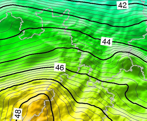
Preface

The Central Office for Geotopography (ZSGT) provides digital cross-border spatial data of the German Federal
States (Laender) to businesses, science, administration and citizens. The ZSGT is operated at the Service Center
of the Federation for spatial information and geodesy (DLZ) at the Federal Agency for Cartography and Geodesy
(BKG) in its branch office in Leipzig. Spatial data licensed from the ZSGT is provided on behalf of the Working
Commitee of the Surveying Authorities of the Laender of the Federal Republic of Germany (AdV) and is subject to
their conditions and product specifications.

Users profit from a comprehensive spectrum of Internet services that may be conveniently integrated into custom
applications and that continuously access the most current spatial base data. Furthermore, a conventional provision
of data is possible and takes place according to our customers specifications regarding spatial extent, thematic
content, georeferencing or data exchange format.

The data of the federal states (Laender) are merged and technically harmonized at the Service Center. Formal
completeness and format consistency are also checked. Accompanying metadata and overviews of topicality
provide the user transparently with information on the quality of the spatial data.

This Product Catalog is intended to give you an overview of our range of products and services and to support
you in selecting matching products for your individual use case. Moreover, we will inform you about data sources,
topicality, accuracy and possible uses of individual geospatial data.

We would be very happy to receive your comments, ideas or criticism regarding this product catalog. The editorial
team‘s e-mail address is: dlz@bkg.bund.de.

                                                                                                                           3
4
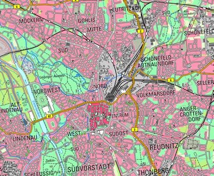
Table of Contents

Table of Contents

Digital Landscape Models
 Basis-DLM                 Digital Basic-Landscapemodel                       6
 LBM-DE                    Digital Land Cover Model for Germany               7

Digital Terrain Models
 DGM5                      Digital Terrain Model, Grid Width 5 m              8
 DGM10                     Digital Terrain Model, Grid Width 10 m             8
 DGM25                     Digital Terrain Model, Grid Width 25 m             8
 DGM50                     Digital Terrain Model, Grid Width 50 m             8

Digital Topographic Maps
 DTK25                     Digital Topographic Map 1:25 000                   9
 DTK50                     Digital Topographic Map 1:50 000                  10
 DTK100                    Digital Topographic Map 1:100 000                 11

Other Digital Products
 DOP20                     Digital Orthophotos, Ground resolution 20cm       12
 DOP40                     Digital Orthophotos, Ground resolution 40cm       12
 GCG                       Quasigeoid of the Federal Republic of Germany     13

Federal/Laender Web Services
                          WebAtlasDE                                         14
                          Geocoding Service for Addresses and Geonames       15

Web Applications
                           BKG Download                                      16
                           BKG Geocoder                                      17
                           Address Batch                                     18

Online Services
                           Our Online Services at a Glance                   19

                                                                                         5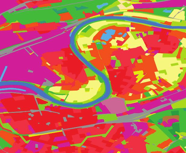
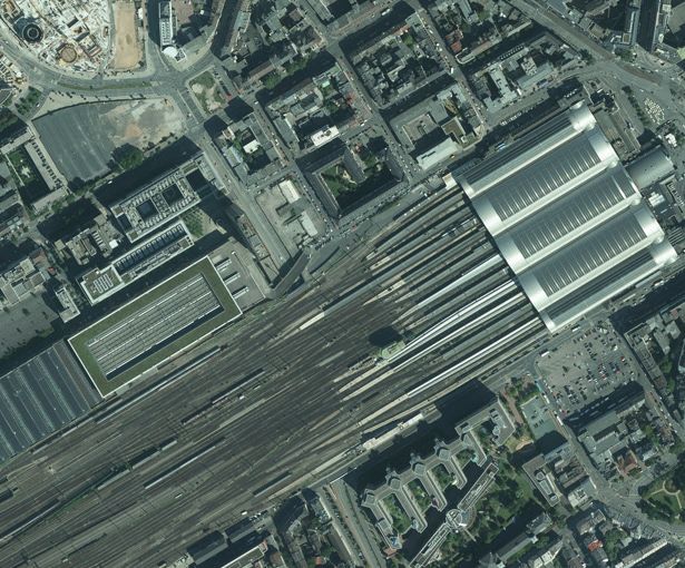
Digital Landscape Models

                                              Digital
                                              Basic-Landscapemodel
                                              (Basis-DLM)

Visualization example Basis-DLM

    Your Benefit –                            Product Description
    Your Added Values                         Description of topographic landscape features in vector format based
                                              on the specifications of the ATKIS® feature type catalog (ATKIS®-OK).
                                              The scope of information of the Basis-DLM is based on the contents
    Federal authorities, Federal State
    authorities and municipalities            of the Topographic Map 1:10 000/1:25 000, though presenting a higher
    Basis for land use plans and a variety    yet positional accuracy (± 3 m) for the most important linear objects.
    of urban planning tasks, cartographic
    basis for the fulfilment of planning      The vector data are not symbolized and can be visualized in applica-
    duties
                                              tions or GIS systems. The feature-structured data allow geometrical
                                              and attributive analyses and data processing.
    Energy suppliers,
    telecommunications
    Deriving high-quality and tailored car-   The dataset is available in two specifications:
    tographic representations, convenient
    plant design and documentation            Compact: Representation of all ATKIS® features in the XML-based
                                              data format of the Norm-Based Exchange Interface (NAS).
    Publishing companies, delivery
    organizations
    Optimized delivery also on roads and      Layers: Allocation of feature types with similar contents to layers
    paths not accessible by vehicle           (content layers). Simplification of original data structure by tieing
                                              nongeometric information to the reference objects with geometric
    Police, fire brigade, rescue              characteristics. Use of ESRI shapefiles.
    services and disaster control
    Model analysis and cartographic
    basis for operational planning and
    subsequent documentation
                                               Update:                   every three months
    Other ranges of application
    Environmental protection and nature                                  digitally on data carrier,
                                               Available:
    conservation, traffic control systems,                               digitally as download
    forestry and agriculture, road
                                               Geographic extent:        Germany
    management, geology, leisure,
    marketing analysis
                                               Data originator:          Surveying Authorities of the Laender

    General
    Scaled map derivation

    6
Digital Landscape Models

Digital Land Cover Model
of Germany
(LBM-DE)

                                                                                    Visualization example LBM-DE

Product Description                                                       Your Benefit –
The LBM-DE (until 2012 DLM-DE) contains areal information on land         Your Added Values
cover according to the European nomenclature of CORINE Land
Cover (CLC). The dataset of the LBM-DE is based on selected areal
                                                                          Land statistics
feature types from the categories settlement, transport, vegetation and
waters of the ATKIS® Basis-DLM, which were in amended to meet the         Rural development
specific requirements of CLC.
                                                                          Research activities for nature and
                                                                          environment
The minimum mapping area of the dataset is one hectare. With the
help of multitemporal satellite image data (main data collection base:
RapidEye 5 m ground pixel resolution, 5 channels), the dataset is
updated with a 3-year revision cycle at the respective year of refe-
rence since the full-coverage first recording in 2009. Since 2012, land
cover and land use are recorded separately with a subsequent auto-
matic transformation into the CLC nomenclature. While the land cover
is recorded using image data, the ATKIS® Basis-DLM of the respective
year of reference serves as a source of information for the aspect of
land use.

 Update:                  3 years

                          digitally on data carrier,
 Available:
                          digitally as download

 Geographic extent:       Germany

 Data originator:         BKG

                                                                                                               7
Digital Terrain Models

                                         Digital Terrain Models
                                         (DGM)

Example DGM5 and DGM10

   Your Benefit –                        Product Description
   Your Added Values                     The Surveying Authorities of the Laender establish Digital Terrain
                                         Models varying in resolution in order to uniformly describe the relief of
                                         the territory of the Federal Republic of Germany.
   Environmental protection
   Preparation of noise maps,
   flood simulations                     The following quality levels are available:

   Traffic                               ▪ Digital Terrain Model grid width 5 m (DGM5)
   Route planning, profile representa-
   tions and volume determination
                                         ▪ Digital Terrain Model grid width 10 m (DGM10)
   Energy supply
   Planning of wind power plants         ▪ Digital Terrain Model grid width 25 m (DGM25)

   Calculation of contours and           ▪ Digital Terrain Model grid width 50 m (DGM50)
   shadings

                                         These models describe the form of the earth‘s surface by a point mass
   Visualizations
                                         that is arranged in a regular grid and georeferenced with regard to
   Telecommunications and mobile         geographic location and altitude.
   radio Geology

                                          Update:                   approximately each year

                                                                    digitally on data carrier,
                                                                    digitally as download,
                                          Available:
                                                                    digitally as view service: WMS,
                                                                    digitally as download service: WFS (wfs_altimeter)

                                          Geographic extent:        Germany

                                          Data originator:          Surveying Authorities of the Laender

   8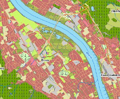
Digital Topographic Maps

Digital Topographic Map
1:25 000
(DTK25)

                                                                                                      Map example DTK25

Product Description                                                               Your Benefit –
The Digital Topographic Map 1:25 000 (DTK25) is a topographic map                 Your Added Values
in raster format generated from the Digital Basic Landscape Model and
the Digital Terrain Model. The symbolization of map objects follows the
                                                                                  Regional planning
rules of the Signaturenkatalog (portrayal catalogue) ATKIS®-SK10/25.              Basis for regional and supraregional
                                                                                  planning proposals and projects, a
The map shows the territory of the Federal Republic of Germany.                   high degree of accuracy and depth
For this purpose, the data sets of the federal states are merged into             of content, abundance of
                                                                                  topographic information, ideal
a nationwide seamless dataset at the BKG. There is no change in
                                                                                  presentation graphics
content, existing differences in the map graphics between the federal
states are not eliminated.     The raster data are divided into different         Leisure activities and tourism
layers according to thematic content elements. In addition to the                 Cartographic basis of analogous and
colored combination edition (sum layer), which contains the complete              digital leisure products (e.g. in
colored map sheet, 24 further single-color thematic single layers are             mobile GPS receivers and
                                                                                  navigation systems), combination
part of the DTK25.
                                                                                  with Digital Terrain Models to
                                                                                  generate 3D animations of real
The data are stored in a uniform raster resolution throughout the                 landscapes
Federal Republic of Germany as single sheets and seamless tiles in
various geodetic reference systems and map projections.                           Police, fire brigade and rescue
                                                                                  services
                                                                                  Large-scale operational planning,
                                                                                  derivation of special maps (e.g. maps
                                                                                  for forest fire fighting briefings or
                                                                                  hydrographic maps)
 Update:                     continuously, 5-year revision cycle of the Laender
                                                                                  Other ranges of application
                             digitally on data carrier,                           Logistics, navigation, mining, agricul-
 Available:                  digitally as download,                               ture and forestry, administration,
                             digitally as view service: WMS                       telecommunications/mobile radio
 Geographic extent:          Germany
                                                                                  Geomarketing
                                                                                  Base map for site analyses or
 Data originator:            Surveying Authorities of the Laender                 defining sales regions, basis for
                                                                                  producing thematic maps (e.g. sales
                                                                                  figures per sales region, particular
                                                                                  branch structure, distribution of
                                                                                  suppliers and competitors)

                                                                                                                       9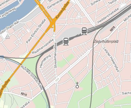
Digital Topographic Maps

                                             Digital Topographic Map
                                             1:50 000
                                             (DTK50)

Map example DTK50

   Your Benefit –                            Product Description
   Your Added Values                         The Digital Topographic Map 1:50 000 (DTK50) contains the raster
                                             data of the „Topographic Map 1:50 000 (TK50)“.

   Regional planning
   Basis for regional and supraregional      The DTK50 is derived computer-aided from the ATKIS®-DLM and
   planning proposals and projects, a        DGM of the federal states.The signature of the map objects follows
   high degree of accuracy and depth         the rules of the ATKIS®-SK50 signature catalog.
   of content, abundance of
   topographic information, ideal
                                             The raster data are divided into layers (individual layers) according
   presentation graphics
                                             to cartographic content elements. In addition to the sum layer, which
   Leisure activities and tourism            contains the complete colored map sheet, 24 other single-color single
   Cartographic basis of analogous and       layers are part of DTK50.
   digital leisure products (e.g. in
   mobile GPS receivers and                  The data are available in a uniform raster resolution covering the whole
   navigation systems), combination
                                             of the Federal Republic of Germany in various geodetic reference
   with Digital Terrain Models to
   generate 3D animations of real            systems and map projections.
   landscapes

   Police, fire brigade and rescue
   services
   Large-scale operational planning,
   derivation of special maps (e.g. maps
   for forest fire fighting briefings or
   hydrographic maps)
                                              Update:                    continuously, 5-year revision cycle of the Laender
   Other ranges of application
   Logistics, navigation, mining, agricul-                               digitally on data carrier,
   ture and forestry, administration,         Available:                 digitally as download,
   telecommunications/mobile radio                                       digitally as view service: WMS

                                              Geographic extent:         Germany
   Geomarketing
   Base map for site analyses or
   defining sales regions, basis for          Data originator:           Surveying Authorities of the Laender
   producing thematic maps (e.g. sales
   figures per sales region, particular
   branch structure, distribution of
   suppliers and competitors)

  10
Digital Topographic Maps
Digital
Topographic Map 1:100 000
(DTK100)
Map example DTK100
Product Description Your Benefit –
The Digital Topographic Map 1:100 000 (DTK100) includes the raster Your Added Values
data on a scale of 1:100 000 that are derived in a computer-aided pro-
cess from the ATKIS®-DLM and DGM of the Laender.
Regional planning
Basis for regional and supraregional
The raster data are subdivided into single levels (layers) according planning proposals and projects, a
to their cartographic content elements. The structure of the layers high degree of accuracy and depth
is defined by the technical guideline of the AdV named Technisches of content, abundance of
topographic information, ideal
Regelwerk für den Datenaustausch von Digitalen Topographischen
presentation graphics
Karten. In addition to the sum layer containing the complete map
image, 24 single-color single layers are part of the DTK100. Please Leisure activities and tourism
note that there may be differences between the individual Laender Cartographic basis of analogous and
regarding map graphics and colour assignment. digital leisure products (e.g. in
mobile GPS receivers and
navigation systems), combination
The data are available area-wide in a uniform raster resolution for the
with Digital Terrain Models to
Federal Republic of Germany in various geodetic reference systems generate 3D animations of real
and map projections. landscapes
Police, fire brigade and rescue
services
Large-scale operational planning,
derivation of special maps (e.g. maps
for forest fire fighting briefings or
hydrographic maps)
Update: continuously
Other ranges of application
digitally on data carrier, Logistics, navigation, mining, agricul-
Available: digitally as download, ture and forestry, administration,
digitally as view service: WMS telecommunications/mobile radio
Geographic extent: Germany
Geomarketing
Base map for site analyses or
Data originator: Surveying Authorities of the Laender defining sales regions, basis for
producing thematic maps (e.g. sales
figures per sales region, particular
branch structure, distribution of
suppliers and competitors)
11Other Digital Products
Digital Orthophotos,
Ground resolution 20/40cm
(DOP20/40)
DOP with ground resolution 40cm
Your Benefit – Product Description
Your Added Values The dataset includes the Digital Orthophotos (DOP) of Germany as
georeferenced, differentially rectified aerial images of the Surveying
Authorities of the Laender. The image data are delivered to the BKG
Regional planning
Emotional and realistic presentation with a ground resolution of 20 cm (1 image pixel = 20 cm x 20 cm).
of planning projects, easily This results in the Germany-wide dataset DOP20, that can be used via
understandable for everybody, web services in full resolution and as DOP40.
foundation for broad acceptance
Single image files can be supplied in flexible resolutions via the web
Documentation
application BKG Download.
Representation of time series as
complete proof of landscapes,
changes, important basic information In addition, detailed information about the topicality of the images is
for questions of regional studies and available via another free web service.
history as well as for preservation of
evidence
Real estate industry
Comprehensive additional informa-
tion on the location of properties,
enhancement of exposés, expres-
sive and informative in combination
with „Points of Interest“ (e.g. public
transport stops, schools, shopping
facilities)
Environment and nature protection Update: continuously, 3-year revision cycle of the Laender
Identification of contaminated sites,
identification and proof of sealed digitally as download (see BKG Download),
Available:
areas, preservation of evidence for digitally as view service: WMS
damages caused by natural events
Geographic extent: Germany
(e.g. effects of floods or storms)
Data originator: Surveying Authorities of the Laender
Other fields of application
Agriculture and forestry, mining,
water management, archaeology,
geology, tourism
12Other Digital Products
Quasigeoid of the Federal
Republic of Germany
(German Combined
Quasigeoid - GCG)
Visualization example Quasigeoid
Product Description Your Benefit –
The German Combined Quasigeoid (GCG) is a model that describes Your Added Values
the course of the zero level of the official height reference surface in
Germany. It denotes the difference between the reference ellipsoid
Direct determination of heights in the
(Ellipsoid of the Geodetic Reference System 1980, GRS80) used in official height system DHHN2016
surveying with satellite navigation systems (e.g. with GPS, GALILEO) using the satellite positioning service
and the official height reference surface that uses the height of the SAPOS®
Normal Amsterdams Peil (NAP). It serves the direct conversion
geometric heights of the European Terrestrial Reference System 1989
(ETRS89/DREF91 Realization 2016) into sea level related heights
of the German First Order Levelling Network 2016 (DHHN2016) and
is compatible with the satellite positioning service SAPOS® of the
German Laender.
The accuracy of the model is 1 cm in the lowlands, 2 cm in the high
mountains and 2 - 6 cm in maritime areas. It includes the whole area of
the German Exclusive Economic Zone, the so-called 200 nautical miles
zone, and thus provides a uniform solution for the whole sovereign
territory of the Federal Republic. The geoid is supplied as one overall
dataset or as five subsets that cover different regions.
GCG2011, January 2012
Update:
GCG2016, December 2016
digitally on data carrier,
Available:
digitally as download
Geographic extent: Germany
Surveying Authorities of the Laender,
Data originator: BKG,
Leibniz University Hannover
13Federation/Laender web services
WebAtlasDE
Map example WebAtlasDE
Your Benefit – Product Description
Your Added Values The WebAtlasDE is a web map service developed jointly by the Fede-
ration and the Laender and is provided by the Federal Agency for Car-
tography and Geodesy (BKG). On the basis of official spatial base
Uniform map style
data it features an attractive, Germany-wide uniform map represen-
A color and a grayscale variant tation in zoom levels from the single building to an overview of Ger-
many. Its efficient realization based on international standards and its
Zoom levels from single building modern cartographic design support various applications.
representation to map of Germany
Base data for the WebAtlasDE are the Basic Landscape Model, house
Good speed of indication
coordinates and building polygons from the Real Estate Cadastre of
Regional planning the Laender as well as the Digital Landscape Models 1:250 000 and
Base map for site analyses, urban 1:1 000 000, which are being maintained at the BKG.
and regional planning
For individuals, education and research as well as commercial uses
Education and research
Presentation of technical data on scales smaller than or equal to 1:15 000 (WebAtlasDE.light), the
internal use of the WebAtlasDE is free of charge.
Leisure activities and tourism
Basis for tourist maps
Police, fire brigade and rescue
services
Operational planning
Other ranges of application Update: annually
Logistics, administration, energy
providers, publishers, agriculture and Available: digitally as view service: WMS, WMTS
forestry, real estate industry
Geographic extent: Germany
Surveying Authorities of the Laender,
Data originator:
BKG
14Federation/Laender web services
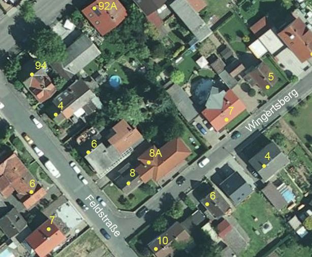
Geocoding Service for
Addresses and Geonames
Visualization example addresses
Product Description Your Benefit –
The geocoding service for addresses and geonames is a joint project Your Added Values
of the Federation and the Laender. The Laender provide the data
basis and the Federal Agency for Cartography and Geodesy (BKG)
Data basis for an exact navigation to
processes the data and operates the web service developed by its a destination address
Service Center. For attributively described addresses and geonames,
the service returns spatial positions as coordinates (geocoding) or Data basis for scale-independent
all addresses and geonames in a given geographical area (reverse presentation of address information
in digital maps and geographical
geocoding).
information systems
The service supports the following interfaces as standardized by the Geomarketing analyses
Open Geospatial Consortium (OGC):
Geocoding services
▪ OpenSearch GeoTemporal Service (OSGTS):
Distribution and utility services
An interface in compliance with the specification OpenSearch
Geo and Time Extensions optimized for the integration into web
Optimum support for the implemen-
applications. tation of §14 Georeferencing of the
EGovG
▪ Web Feature Service (WFS):
An interface in compliance with the Web Feature Service (WFS) for
more complex applications.
Update: annually
digitally as geocoding and search service: WFS and
Available:
OpenSearchGeoTemporal Service
Geographic extent: Germany
Data originator: Surveying Authorities of the Laender
15Web applications
BKG Download
Application example
Your Benefit – Product Description
Your Added Values The BKG Download allows all authorized users to download and store
Digital Orthophotos (DOP) and Digital Topographic Maps (DTK) via an
interactive selection of 1 km x 1 km tiles in a map.
Urban and village planning
Ecological, pedological, agricultural, Each tile is stored as an image file (.tiff) and a metadata file (.meta) is
gepgraphical or archaeological also provided, which contains information regarding topicality.
studies
Up to a resolution of 20 x 20 centimeters, the ground resolution of the
Water engineering works
DOP may be chosen freely. The DTKs can be downloaded in scales
Determination of coastal changes
from 1:25 000 to 1:100 000.
Determination of contaminated soils
Historical comparisons
Flight simulation
Update: -
Available: interactive interface (Java Applet)
Geographic extent: Germany
Originator: BKG
16Web applications
BKG Geocoder
Application example
Product Description Your Benefit –
The application BKG Geocoder allows to assign coordinates to postal Your Added Values
addresses, place names or postal codes. Prerequisite is the purchase
of the right to use BKG‘s geocoding service (gdz_geokodierung) from
Assignment of position coordinates
BKG. to addresses
With the help of this application, large quantities of address data Free use of the web application after
may easily be geocoded (i.e. assigned to coordinates). The BKG purchase of a service license
Geocoder expects spreadsheets in CSV format for automatic geoco-
Optimum support for the
ding and the results, in turn, are written to a CSV file. In addition, the
implementation of §14
application provides possibilities for manual verification and optimiza- Georeferencing of the EGovG
tion of the automatically generated geocoding results.
Application provides possibilities for
manual verification and optimization
of the automatically generated results
Intuitive and easy handling, compre-
hensive online help
Update: -
Available: interactive interface (JavaScript)
Geographic extent: Germany
Originator: BKG
17Web applications
Address Batch
Application example
Your Benefit – Product Description
Your Added Values The Address Batch allows the assignment of coordinates to addresses,
provided that you have purchased the right to use BKG‘s geocoding
Assignment of coordinates service (wfs_geokodierung).
to addresses
There are two possible uses:
Free use of the web application
after purchase of a service license
After entering a single address using the interface, the result is shown
Optimum support for the on the screen.
implementation of §14
Georeferencing of the EGovG After the upload of a list of addresses in CSV format, the results are
written to a CSV file. Further hints are provided by the applications
help menu.
Update: -
Available: interactive interface (Java Applet)
Geographic extent: Germany
Originator: BKG
18Online Services
Our Online Services at a Glance
Abbreviations and Explanations of the Services
▪ WMS: Standardized Web Map Service based on specifications of the Open Geospatial Consortium (OGC)
for requesting and providing maps as raster data. A WMS server can generate maps from raster
data and vector data. Attributes may also be retrieved when the WMS is being generated from vector
data.
▪ WMTS: Standardized Web MapTile Service based on specifications of the Open Geospatial Consortium
(OGC) for requesting and providing maps as tile-based raster data. The map is pregenerated by the
server for previously chosen zoomlevels and fragmented into small tiles. Thus, the application may
access the image tiles in a performant manner.
▪ WFS: Standardized Web Feature Service based on specifications of the Open Geospatial Consortium
(OGC) for requesting and providing geospatial as object-structured vector data (features). The re-
sults are returned as XML-based Geography Markup Language (GML) data.
▪ OLS: Standardized Open Location Service based on specifications of the Open Geospatial Consortium
(OGC) for requesting and providing geospatial as object-structured vector data (features). The re-
sults are returned as XML-based Geography Markup Language (GML) data.
▪ CSW: Standardized Web Catalog Service based on specifications of the Open Geospatial Consortium
(OGC) and the International Organization for Standardization (ISO) for requesting and providing
information (meta data) about geospatial data and geospatial data services.
▪ GDZ: Services providing other interfaces. For example, the geocoding/place search provides, an interface
that is conform with the specification OpenSearch Geo and Time Extensions (OSGTS) of the Open
Geospatial Consortium (OGC). This interface is optimized for the integration into web applications.
19Online Services
List of Available Services
Content Name
WMS Digital Topographic Map 1:25 000 in color and grey values wms_dtk25
WMS Digital Topographic Map 1:50 000 in color and grey values wms_dtk50
WMS Digital Topographic Map 1:100 000 in color and grey values wms_dtk100
WMS Digital Orthophotos ground resolution 40 cm wms_dop40
WMS Digital Orthophotos ground resolution 20 cm or 40 cm wms_dop
WMTS Digital Orthophotos ground resolution 20 cm wmts_dop
WMS Digital Terrain Model grid width 10 m wms_dgm10
in 4 visualizations (height information, Colormap, relief, shading)
WMS Digital Terrain Model grid width 25 m wms_dgm25
in 4 visualizations (height information, Colormap, relief, shading)
WMS Digital Terrain Model grid width 50 m wms_dgm50
in 4 visualizations (height information, Colormap, relief, shading)
WMS Official Germany-wide Map Service of Federal Government and Laender wms_webatlasde
WMS Official Germany-wide Map Service of Federal Government and Laender wms_webatlasde_grau
in gray values
WMTS Official Germany-wide Map Service of Federal Government and Laender wmts_webatlasde
20Online Services List of Available Services Content Name WMTS Official Germany-wide Web Map Service of Federal Government and Laender wmts_webatlasde_grau in gray values WMS Official Germany-wide Web Map Service of Federal Government and Laender wms_webatlasde.light (scale range
Contacts
Federal Agency for Cartography and Geodesy
Central Office for Geotopography
Karl-Rothe-Straße 10-14
04105 Leipzig
Unit GDL2.1 • Dienstleistungszentrum (Service Center)
Tel.:     +49 (0) 341 5634-333
E-Mail: dlz@bkg.bund.de
Internet: www.bkg.bund.de
          www.zsgt.de

As of 01/2021
You can also read


