PROFECY - Processes, Features and Cycles of Inner Peripheries in Europe - Annex 1. Conceptual Framework - ESPON
←
→
Page content transcription
If your browser does not render page correctly, please read the page content below

PROFECY – Processes,
Features and Cycles of Inner
   Peripheries in Europe
  (Inner Peripheries: National territories facing
challenges of access to basic services of general
                    interest)

               Applied Research

                 Final Report

        Annex 1. Conceptual
            Framework
              Version 07/12/2017
This applied research activity is conducted within the framework of the ESPON 2020 Cooperation
Programme, partly financed by the European Regional Development Fund.

The ESPON EGTC is the Single Beneficiary of the ESPON 2020 Cooperation Programme. The
Single Operation within the programme is implemented by the ESPON EGTC and co-financed by
the European Regional Development Fund, the EU Member States and the Partner States,
Iceland, Liechtenstein, Norway and Switzerland.

This delivery does not necessarily reflect the opinion of the members of the ESPON 2020
Monitoring Committee.

Authors
Andrew Copus, Nordregio, (Sweden)
Joan Noguera, Institute for Local Development, University of Valencia (Spain)

Advisory Group
Project Support Team: Barbara Acreman and Zaira Piazza (Italy), Eedi Sepp (Estonia), Zsolt
Szokolai, European Commission.
ESPON EGTC: Marjan van Herwijnen (Project Expert), Laurent Frideres (HoU E&O), Ilona
Raugze (Director), Piera Petruzzi (Outreach), Johannes Kiersch (Financial Expert).

Information on ESPON and its projects can be found on www.espon.eu.

The web site provides the possibility to download and examine the most recent documents
produced by finalised and ongoing ESPON projects.

This delivery exists only in an electronic version.

© ESPON, 2017

Printing, reproduction or quotation is authorised provided the source is acknowledged and a copy
is forwarded to the ESPON EGTC in Luxembourg.

Contact: info@espon.eu

a

             PROFECY – Proceses, Features and
             Cycles of Inner Peripheries in Europe

© Image: ETIFOR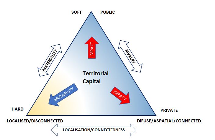
Table of contents
List of Figures ............................................................................................................................. ii
Abbreviations ............................................................................................................................. iii
1      What the academic literature tells us ................................................................................ 1
       1.1 The changing concept of distance ............................................................................ 1
       1.2 A hybrid concept combining two strands of research ............................................... 2
            1.2.1 Mapping Economic Potential ........................................................................... 2
            1.2.2 The Modern World System, the Semi-Periphery, and Peripheralization ......... 3
2      Inner Periphery in the European Regional Policy Discourse ............................................ 5
3      Primary Peripheralization and Secondary Marginalization Processes.............................. 7
4      Inner Peripheries and Territorial Capital ........................................................................... 9
References .............................................................................................................................. 11

ESPON 2020                                                                                                                                     i
List of Figures
Figure 4.1: Seven kinds of territorial capital .............................................................................. 9

Figure 4.2: The innovative cross of territorial capital37 .............................................................. 9

Figure 4.3: An enhanced typology of Territorial Capital .......................................................... 10

ESPON 2020                                                                                                                   ii

Abbreviations
CLLD         Community-Led Local Development
DFR          Draft Final Report
ESIF         European Structural & Investment Funds
ESPON        European Territorial Observatory Network
EU           European Union
IP           Inner Periphery(ies)
ITI          Integrated Territorial Investment
LEADER       Liaison Entre Actions de Développement de l'Économique Rurale
NUTS         Nomenclature of Territorial Units for Statistics
PROFECY      Processes, Features and Cycles of Inner Peripheries in Europe
SGI          Services of General Interests

ESPON 2020                                                                   iii
1 What the academic literature tells us
1.1    The changing concept of distance
At face value, the two words “Inner” and “Periphery” do not seem to fit together, rather they
contradict each other; how can a locality be both “on the edge” and “inner”? In order to
understand what is meant by this term it will be necessary to explain how it is the “child” of
certain changes both in the policy and academic discourses, and, more fundamentally, of very
important real-world socio-economic trends.

In recent years the original (spatial) meaning of the term “peripherality”, which was all about
the economic and social costs and penalties faced by locations at a distance from the main
“hubs” of economic activity in Europe, where the benefits of agglomeration economies were
maximised, has become associated with a range of “analogous” meanings, which are to do
with socio-economic “marginality” in an aspatial sense 1 (p. 368). Within this project however
the term “peripheralization a” is preferred to “marginalisation”, since the former draws attention
to the role of connectedness (spatial or not, see below), whereas the latter may simply denote
low levels of socio-economic development or performance, for whatever reason.

Our world has changed: New information and communication technologies are gradually,
selectively and subtly transforming the environment within which interactions (between
individuals, businesses, and institutions) take place. Gradually, both within academic circles
and within popular culture, we are changing our concepts of “space” and “proximity”.
Geographical, or “Euclidean” space is still the context for flows of goods, and service
interactions which necessitate physical face-to-face contact - basic physics suggests that this
will always be so. In this sphere, proximity is still measured in kilometres, travel-time, or
travel-cost. However, it is also true that our economy and society are increasingly dependent
upon flows of information as well. In this arena physical distance, travel time and travel cost
are no longer the key constraints to interaction. Information can travel across networks where
other forms of “organised proximity” (social, legal, institutional) matter much more 2.

According to Bock 3 (p. 5) “Whereas in the past, the main cause [of uneven development] was
ascribed to geography, this has changed in the sense that the lack of resources is now
explained as resulting from a lack of socioeconomic and political connections (‘connectivity’)
and, hence, of relational ‘remoteness’ that is not necessarily bounded to geographical
location…Geographical remoteness, as such, therefore does not cause marginalisation, nor
does central location promise prosperity”

As a consequence of the rising importance of this second kind of networking it is now possible
to conceive of the peripherality of a locality on two distinct levels – in a geographical sense,
and in terms of “organised proximity”.

a
 Here we use the American spelling, with a “z”, since the concept originated with a US sociologist, and
much of the European literature also follows the US spelling.

ESPON 2020                                                                                           1
Such a view of the world, where every locality, business, institution and individual operates
within both geographical space and within aspatial networks is the key to understanding and
distinguishing the several “faces” of the concept of “inner peripheries”. In this project we will
not attempt to establish a single definition. Instead we will consider the various
manifestations, explain how they relate to each other within a common conceptual framework,
and explore their implications in terms of delimiting their incidence across Europe, and in
terms of the intervention logic(s) for policy.

1.2     A hybrid concept combining two strands of research
The Inner Periphery concept which has emerged in the European regional policy discourse
seems to have two “roots”. Both of these originated independently during the 1970s and
1980s. At that time there was little interaction between them. However, more recently,
features of both have been incorporated into the same policy discourse, increasing its
chameleon-like flexibility rather than its coherence. The first of these owed much to positivist
spatial analysis, whilst the second emerged from the structuralist school. A key name in the
first was David Keeble, whilst Immanuel Wallerstein was founding father of the second.

1.2.1    Mapping Economic Potential
During the 1980s and ‘90s considerable efforts were made to measure spatial peripherality,
using various spatial models, especially one which used Newtonian gravity as an analogy for
“economic potential” 4,5,6,7,8,9,10,11. Economic potential was in many ways an indicator designed
as a proxy to measure the effects of agglomeration, as described by classic regional
development models of Myrdal 12, Hirschmann 13 and Friedmann 14, and more recently
quantified by the New Economic Geography school 15. Many very attractive maps were
produced, the parameters of the models were carefully tested and adjusted using different
forms of transport to explore the assumed effects of geographic peripherality on different
aspects of economic and social activity.

Those involved in this research were very aware that such adjustments could have the effect
of either accentuating continental scale differences between the outer-most regions of Europe
and the core regions (sometimes known as “the blue banana”), or of highlighting smaller scale
differences within countries 1617. Such “enclaves” of peripherality were particularly striking if
they were identified in what is commonly known as “Central Europe”. However it is fair to say
that, since this research roughly coincided with the accession of Spain and Portugal (1986),
and Sweden, and Finland (1995), the focus of the policy debate was very much upon the kind
of peripherality experienced by the sparsely populated regions of the North and the West. In
fact, although the peripheral regions of the Iberian Peninsula qualified for designation under
Objective 1 of the Structural Fund, the better performing Nordic regions were given a new
designation (Objective 6) on grounds of their peripherality. Central European “enclaves”
(many of them still outside the EU at this stage), received little explicit policy recognition or
research attention at this time.

ESPON 2020                                                                                     2
Although it was widely assumed that the effects of peripherality could be predicted as a
function of distance from centres of economic activity, academics were pointing out that
despite the sophistication of the models and the maps, and the high level theorising about
agglomeration, we understood much less about the socio-economic processes which
translated these into local variations in socio-economic performance. Even as early as 1969
Peter Gould stated that peripherality was “…a slippery notion…one of those common terms
everyone uses until faced with the problem of defining and measuring it" 18 (p.17).

1.2.2   The Modern World System, the Semi-Periphery, and Peripheralization
The American social historian Immanuel Wallerstein 1920 is generally associated with the
structuralist perspective which comprehends both modern history and the geography of
development on a grand scale. The key aspect of this theory is the division of the world’s
countries into three groups, the core, the periphery, and the semi-periphery. This typology is
associated with the distribution of power, and processes of capitalist exploitation, whereby the
core’s economic development was dependent upon cheap sources of raw material and labour
in the periphery. Semi- periphery countries shared in the exploitation of the periphery, and
aspired to become part of the core, but lacked their freedom of action and dominance.

The inner/internal periphery concept seems to have been strongly influenced by the Modern
World System theory. Early applications of the term were to Appalachia 21,22 and Lesotho 23. In
a European context Nolte 24,25 argued that enduring inner peripheries of Southern Europe owe
their existence to being for many centuries in the border-region between the Christian and
Muslim worlds. Vaishair and Zapletelova 26 in their study of small towns in Moravia describe
sparsely populated areas along national borders and where the topography is hilly as an
internal periphery. They also refer to the Alps as being an inner periphery “from a West
European view”24 (p.72). Similarly, in a Russian context Kaganskii 27 defines the inner
periphery in terms of rural areas which are relatively close to centres of economic activity, but
nevertheless lagging themselves.

Naumann and Fischer-Tahir 28 (p.9) have recently argued that peripheries are social
constructs, rather than fixed geographical features; “we interpret ''peripheries'' as the outcome
of complex processes of change in the economy, demography, political decision-making and
socio-cultural norms and values.”

Reviewing recent literature relating to rural decline in Germany, the same authors26 (p.17)
point to “the multilayered disconnection of rural regions and their marginalization, … the new
peripheries as disconnected in economic terms and as areas facing rapid demographic
change and population ageing. Poor infrastructure, e.g., public transport, health facilities and
educational services, lead to loss of quality of life for the inhabitants concerned. In concert,
the media abounds with negative images, e.g., newspaper articles on "dying villages" and
"empty" regions plagued by unemployment and alcoholism, and "contaminated" by right-wing
extremism …”

ESPON 2020                                                                                     3
What is striking about the recent sociological literature is that it focuses very much on the
process of “peripheralization” rather than with mapping or measuring it. Thus:

“Peripheralization refers to a spatially organized inequality of power relations and access to
material and symbolic goods that constructs and perpetuates the precedence of the centres
over areas that are marginalized. Since peripheries are frequently localized as or within
regions conceived in dominant discourses on a national or transnational scale as the
apparently "natural" edges - such as border or other regions spatially removed from the
centres of capital accumulation and the production of things with a recognized exchange
value, the territorialization of peripheries fosters their reification. … The label "peripheral" is
predominantly attached to the rural areas and small and medium-sized towns or to space
within large urban agglomerations that are marginalized in terms of income opportunities,
housing, traffic structures, and access to educational, medical or other infrastructural
facilities.”26 (p.18-19)

In an interesting twist Leibert 29 links peripheralization in post socialist Central and Eastern
Europe to Scholz’s theory of “Fragmented Development”, which argues that globalisation has
increased global inequalities, with the result that some rural areas are increasingly becoming
“new peripheries… home to people who are redundant as workers, consumers and
producers.”

Because it is liberated from fixed or slowly changing geographical features, operating within
socially constructed space and networks, peripheralization as a process is extremely flexible
in terms of context and scale – it can be applied to countries, regions, cities or
neigbourhoods1 (p.369). However, Kuhn goes on to explain, herein lies a pitfall – it becomes
indistinguishable from the concept of marginalisation. Similarly Naumann and Fischer-Tahir
note that “… the theoretical saturation of the term constitutes a deficit, leaving unsettled the
question of whether the peripheralization approach can produce a more substantial
theoretical concept. … is peripheralization just another word for spatially structured political
and social- marginalization and dependency?”26 (p.10).

ESPON 2020                                                                                       4
2 Inner Periphery in the European Regional Policy Discourse
As far as we are aware the term “inner periphery” (or in this case “internal periphery”) was first
used in a European policy document in the background report prepared for the Territorial
Agenda 2020 meeting in Gödöllő, Hungary in 2011 30. The description is quoted below at
length, since it seems to be the starting point for the subsequent discussion of inner
peripheries:

“Internal peripheries are unique types of rural peripheries in European terms. The vast
majority of these areas are located in Central and Eastern and in Southeast Europe and most
of them have serious problems. Their peripherality comes primarily from their poor
accessibility and paucity of real urban centres where central functions can be concentrated.
These problems derive from the historical under-development of these territories and they are
often compounded by specific features of the settlement network or social characteristics. The
main problems of these areas are their weak and vulnerable regional economies and their
lack of appropriate job opportunities. In these circumstances negative demographic
processes, notably out-migration and ageing of the population, are getting stronger and
stronger. These trends create the conditions for social exclusion, and even territorial
exclusion, from mainstream socio-economic processes and opportunities. While rural
ghettoes are mainly a result of social factors, ethnic segregation can make difficult situations
worse. This is the case, for example, in rural peripheries of Slovakia, Hungary and Romania
where there are areas with high proportions of Roma population.”28 (p.57)

Later in the document the authors call for analysis of internal peripheries by the ESPON
programme28 (p.87).

There is no reference to “internal peripheries” in the final TA2020 text b, which is presumably
why the ESPON Geospecs project concluded “The concept of Inner Peripheries (IP) as such
is new in the European policy arena, as illustrated by the fact that there are no policy
documents dealing explicitly with it…” 31 (p.1). The Geospecs team also (surprisingly) find no
academic literature, and proceed to base their report on interviews with policy stakeholders in
Belgium, Netherlands and Germany. They conclude that inner peripheries are defined by
socio-economic rather than geographic characteristics, or distance from centres of economic
activity. Often they are affected by economic restructuring; the loss of a key industry and high
unemployment. As such, unlike true geographic specificities they are mutable or transient,
rather than permanent.

Generally speaking the Geospecs report illustrates the risk associated with abandoning
spatial (in)accessibility as a defining feature for inner peripheries: It becomes difficult to
distinguish inner peripheries from any other kind of lagging rural or semi-rural area.

b
        http://ec.europa.eu/regional_policy/en/information/publications/communications/2011/territorial-
agenda-of-the-european-union-2020 [accessed 6th April 2016]

ESPON 2020                                                                                            5
In commissioning this project the ESPON 2020 programme recognises and avoids this pitfall by drawing on a growing body of work relating to access to Services of General Interest (SGI). This is more than a question of choice of indicators – it shifts the concept of inner peripheries away from the concept of “economic potential” and towards the quality of life, or well-being of rural inhabitants. This in turn links them to demographic issues, such as rural- urban migration, and ageing. It also resonates with the impacts of austerity on service provision, and the longer-term effects of new public management, universal service obligations and “territorial equivalence”. This seems to suggest that the concept of inner peripheries which is emerging is not simply a Central European analogue of the kind of “economic potential” peripherality observed in Northern and Western Europe, but rather one which has more in common with the discourses on social exclusion and well-being. The Italian policy initiative to support “Inner Areas” 32,33 has much in common with the concept implied by the recent ESPON project call. The so called “aree interne” (internal, inner or interior areas) are conceived as rural areas subject to strong centrifugal forces - demographic decline, migration, abandonment of use and management of land, natural hazards, isolation, low accessibility to services and infrastructure, economic marginalization. These render the inner areas less able to sustain place-based development processes capitalising on local territorial capital in order to enhance their competitiveness. They can be viewed as a special type of inner periphery. Here too, the primary definitional indicators relate to access to Services of General Interest. However an additional source of terminological confusion arises between the Anglophone research tradition, which is used to the idea that the “periphery” is indeed around the (Northern and Western) edges of the country, and that of the Mediterranean and Iberian countries, where major cities are located on the coast, and peripherality is associated with “the interior”, or “inner areas”. When Austria acceded in 1995 demographic and economic development vulnerabilities in mountain areas (which are inner peripheries “in all but name”) could not be addressed by Objective 6, but resulted instead in designation under Objective 5b. Later on support was continued through a very active participation in LEADER, together with national regional policy interventions tailored to the challenges of these areas 34. ESPON 2020 6
3 Primary Peripheralization and Secondary Marginalization
  Processes
It is not the intention here to offer a single and exclusive definition of inner peripheries. Rather
the goal is to identify the key processes which drive the evolution of Inner Peripheries.
Arguable the distinguishing characteristic of an inner periphery is that its potential for
development, or its quality of life, is being adversely affected by poor connectivity of some
kind. This may be due to its location within “Euclidean space” (as in the Economic Potential
models), or to poor access to services, or it may be due to aspects of “organised proximity”,
through which it is excluded from mainstream economic activity, and unable to derive benefits
from globalisation. Thus peripherality may be both spatial or aspatial7, and is often a mixture
of both, but the defining feature, the driver, is the weakness of interaction, the lack of
connectedness, rather than the resulting lagging socio- economic development. Thus all inner
peripheries tend to be lagging behind in socio-economic development, but not all lagging
areas are inner peripheries.

Our review of the academic and policy literature above leads us to conclude that there are
broadly speaking three sets of conditions which result in inner peripherality:

1. Being an “enclave” of low accessibility to centres of economic activity (economic
    potential), surrounded by areas which are more accessible. In other words these are
    simply localities which have relatively high levels of conventional peripherality, but which
    are not “on the edge” of Europe.

2. Having poor access to services of general interest, whether this is a consequence of
    geographic remoteness, or to changing service delivery technologies, or to austerity, or
    other changes in provision such as privatisation.

3. An absence of “relational proximity”, and exclusion from “the mainstream” of economic
    activity, due to low levels of interaction with the wider world. These are social and
    institutional characteristics, of individuals, groups, firms, or organisations, rather than
    geographic features. They are often associated with disconnection from the centres of
    political power, and a lack of influence in terms of governance These conditions may
    affect even geographically accessible regions, and such marginalisation processes are
    sometimes termed “peripheralization”.

These three conditions may be described as the primary processes which are responsible for
the development of Inner Peripheries. This does not imply that they lead to three discrete
types of inner periphery. In reality most areas which can be identified as Inner Peripheries
seem to be affected by combinations of at least two of the primary processes described
above. Furthermore, in most of them the primary processes of peripheralization are
associated with a range of secondary marginalisation processes. These are different from the
primary peripheralization processes in that they are not driven by distance from centres of
economic activity, poor connectedness, or lack of interaction, and they can occur anywhere,

ESPON 2020                                                                                        7
not just in Inner Periphery contexts. Thus most Inner Peripheries can be conceived as complex hybrid phenomena, in which one or more of the primary processes acts as a driver, but a range of secondary marginalisation processes exacerbate the situation. The three primary processes and commonly associated secondary marginalisation processes are presented in the form of three “descriptive models” in Section 5 of the main report. ESPON 2020 8
4 Inner Peripheries and Territorial Capital
The development of appropriate strategies for Inner Peripheries can be further supported by
an enhanced perspective of territorial capital. Here we use the ESPON EDORA project final
report 35 as a starting point. Assets Based Community Development, (ABCD) 36, is an
approach which seeks to realise the full potential of a locality, by utilising all forms of capital
(Figure 4.1).

Figure 4.1: Seven kinds of territorial capital 37

The seven forms of capital used in in these asset based approaches to rural community
development can be differentiated according to a theoretical taxonomy by Camagni 38. This
classifies all potential sources of territorial capital in a three-by-three matrix, building upon the
two dimensions of rivalry and materiality (Figure 4.2).

Figure 4.2: The innovative cross of territorial capital37

The value of such a typology of territorial capital is that it draws attention to the full range of
assets which play a role in local and regional development. This is beneficial since it is

ESPON 2020                                                                                         9
increasingly recognised that some “softer”, and therefore more difficult to measure, forms of
capital have been neglected by policy. It is to be hoped that drawing attention to them will
result in innovative new forms of intervention, with greater capacity to tackle complex forms of
marginalisation.

We suggest that in the context of Inner Peripheries a third axis of differentiation could be
extremely helpful. This third axis could be labelled “localisation/connectedness” (Figure 4.3). It
is intended to differentiate elements of territorial capital along a scale from those which are
localised and disconnected, to those which are difuse, aspatial or highly connected. Some
examples are shown in Figure 4.3. Thus regional transport infrastructure (i.e local roads and
commuter lines) is a hard form of territorial capital, which is localised and fixed. On the other
hand business networks, i.e. the private transaction networks of individual firms could be
placed anywhere along the horizontal axis, from localised and disconnected on the left, to
highly connected on the right (as in Figure 4.2). Territorial governance is very much a soft
form of capital, and again, it could potentially be placed anywhere along the
localisation/connectedness axis.

Figure 4.3: An enhanced typology of Territorial Capital

We believe that this classification of territorial capital has some value as a heuristic device for
policy makers considering how to tackle peripheralization in their region or locality, by
prompting them to assess and consider the extent to which elements of territorial capital need
to be shifted to the right, i.e to become more connected and interactive.

ESPON 2020                                                                                     10
References

1 Kühn, M. (2015) Peripheralization: Theoretical Concepts Explaining Socio-Spatial Inequalities,

European Planning Studies, 23:2, 367-378, DOI: 10.1080/09654313.2013.862518.
2   Torre, A., and Rallet, A. (2005) Proximity and localization. Regional Studies, 39 (1), 47– 59.
3Bock, B. (2016) Rural Marginalisation and the role of Social Innovation: A Turn Towards Nexogenous
Development and Rural Reconnection. Sociologica Ruralis DOI: 10.1111/soru.12119.
4Keeble, D., Offord, J., and Walker, S. (1988) Peripheral Regions in a Community of Twelve Member
States, Commission of the European Community, Luxembourg
5 Schürmann, C.; Spiekermann, K.; and Wegener, M. (1997): Accessibility indicators. Berichte aus dem
Institut für Raumplanung 39. Dortmund: IRPUD.
6Wegener, M.; Eskilinen, H.; Fürst, F.; Schürmann, C.; and Spiekermann, K. (2000): Geographical
Position. Study Programme of European Spatial Planning. Working Group 1.1. Final Report, Part 1.
Dortmund: IRPUD.
7Copus, A. (2001) From Core-Periphery to Polycentric Development; Concepts of Spatial and Aspatial
Peripherality, European Planning Studies, 9:4, 539-552.
8 ESPON (2004) Transport services and networks: territorial trends and basic supply of infrastructure for
territorial   cohesion,     final    report  for      ESPON         project    1.2.1.      Luxembourg.
https://www.espon.eu/main/Menu_Projects/Menu_ESPON2006Projects/Menu_ThematicProjects/transp
orttrends.html [Accessed 6th April 2016]
9Porter, M. E. (1995): The Competitive Advantage of the Inner City. Harvard Business Review 73:3,55-
71.
10 ESPON (2004) Transport services and networks: territorial trends and basic supply of infrastructure

for     territorial cohesion,    final   report for    ESPON        project   1.2.1.    Luxembourg.
https://www.espon.eu/main/Menu_Projects/Menu_ESPON2006Projects/Menu_ThematicProjects/transp
orttrends.html [Accessed 6th April 2016]
11Schürmann, C. and Spiekermann, K. (2014): Update of maps: Travel time matrices on road, rail, air
and multimodal for 2001, 2006, 2011 and 2016. ESPON Matrices. Final Report. Luxembourg and
Dortmund: ESPON, S&W.
12   Myrdal, G. (1957) Economic Theory and Under Developed Regions, London.
13   Hirschman, A. (1958) The Strategy of Economic Development, New Haven, Yale University Press.
14Wight, J. B. (1983) From Centre/Periphery to Territory/Function: John Friedmann in Transition, in
Hansen J C, Naustdalslid J and Sewel J, Centre-Periphery Theory: Theory and Practice, Sogndal.
15 Fujita, M., Krugman, P., and Venables, A. (1999) The Spatial Economy; Cities, Regions and
International Trade, MIT Press, Cambridge, Mass.
16 Schürmann, C., and Talaat, A. (2000): Towards a European Peripherality Index. Final Report.

Berichte aus dem Institut für Raumplanung 53. Dortmund: IRPUD.
17ESPON (2009) Territorial Dynamics in Europe: Trends in Accessibility, Territorial Observation No.2,
Luxembourg.               https://www.espon.eu/export/sites/default/Documents/Publications/Territoria
lObservations/TrendsInAccessibility/to-no2.pdf [Accessed 6th April 2016]
18Gould, P. (1969) Spatial Diffusion, Commission on College Geography, Association of American
Geographers, Washington DC.
19   Wallerstein, I. (1974) The Modern World System, New York Academic Press.
20Wallerstein, I. (1991) Geopolitics and Geoculture: Essays on the Changing World System, Cambridge
University Press Cambridge.
21 Walls, D. (1978) "Internal colony or internal periphery? A critique of current models and an alternative
formulation." Colonialism in Modern America: The Appalachian Case 319-49.
22 Hanna, S. (1995) Finding a place in the world-economy: Core-periphery relations, the nation-state

and the underdevelopment of Garrett County, Maryland. Political Geography 14.5: 451-472.
23Weisfelder, R. (1992) Lesotho and the inner periphery in the new South Africa. The Journal of Modern
African Studies 30.04: 643-668.

ESPON 2020                                                                                             11
24   Nolte, H. (ed.) (1991) Internal Peripheries in European History, Göttingen, Musterschmidt.
25Nolte, H. (2006) A chain of internal peripheries along the old Muslim-Christian border or: Why is
Europe’s South so poor?, in Tausch, A. and Herrmann, P., 2006. Dar al Islam. The Mediterranean, the
World System and the Wider Europe. Vol. 2: The Chain of Peripheries and the New Wider Europe.
Hauppauge, New York: Nova Science Publishers.
26Vaishar, A., and Zapletalová, J. (2008) Small towns as centres of rural micro-regions. European
Countryside 2,·70-81.
27Kaganskii, V. (2013) Inner Periphery is a New Growing Zone of Russia’s Cultural Landscape,
Regional Research of Russia, 3:1, 21–31.
28Naumann, M. and Fischer-Tahir, A. eds., 2013. Peripheralization: The Making of Spatial
Dependencies and Social Injustice. Springer Science & Business Media.
29 Leibert, T., 2013. The Peripheralization of Rural Areas in Post-socialist Central Europe: A Case of

Fragmenting Development? Lessons from Rural Hungary. In: Naumann and Fischer-Tahir,
Peripheralization (pp. 101-120). Springer Fachmedien Wiesbaden.
30 Ministry of National Development and VÁTI Nonprofit Ltd., (2011) The Territorial State and

Perspectives of the European Union, 2011 update, Background document for the Territorial Agenda of
the European Union 2020, presented at the Informal Meeting of Ministers responsible for Spatial
Planning and Territorial Development on 19th May 2011 Gödöllő, Hungary
http://ec.europa.eu/regional_policy/sources/policy/what/territorial-
cohesion/territorial_state_and_perspective_2011.pdf [Accessed 6th April 2016]
31 ESPON Geospecs (2014) Inner Peripheries: a socio-economic territorial specificity, Luxembourg.
https://www.espon.eu/export/sites/default/Documents/Projects/AppliedResea
rch/GEOSPECS/FR/GEOSPECS_Final_Report_inner_peripheries_v14.pdf, [Accessed 6th April 2016]
32 Lucatelli, S., Carlucci, C., Guerrizio, M., (2013) A strategy for the Inner Areas of Italy. Paper

presented at the European Rural Futures Conference, Asti, Italy.
33 Mantino, F., and Fano, G., (2015) New concepts for territorial rural development in Europe: the case
of most remote rural areas in Italy, Paper presented at the XXVI Congress of the European Society of
Rural Sociologist, Aberdeen August 18-21 2015.
34 Dax, T., Fidlschuster, L., Fischer, M., Hiess, H., Oedl-Wieser, T. and Pfefferkorn, W. (2016) Regionen

mit Bevölkerungsrückgang, Experten-Impulspapier zu regional- und raumordnungspolitischen
Entwicklungs- und Anpassungsstrategien, Analyse und strategische Orientierungen, Endbericht, Wien:
Bundeskanzleramt, 96S. http://www.zukunftsraumland.at/index.php?inc=download&id=1172.
35Copus, A. (Ed.) (2010) European Development Opportunities for Rural Areas, Final Report, EDORA
project, ESPON 2013/1/2.….especially Annex 1 part 28 p1121
36 Braithwaite; K. (2009). Building on What You Have Got – A guide to Optimising Assets, The Rural

Action Research Programme Briefing Series, Carnegie UK Trust, Dunfermline (UK).
37Courtney, P., Talbot, H. & Skuras, D. (2010) Establishing the potential for territorial cooperation.
EDORA, Applied Research Project, ESPON, UHI Millennium Institute, Luxembourg, Inverness.
38Camagni, R. (2008). Regional Competitiveness: Towards a Concept of Territorial Capital, in:
Modelling Regional Scenarios for the Enlarged Europe, Springer, Berlin-Heidelberg, pp.33-47.

ESPON 2020                                                                                           12
ESPON 2020 – More information
ESPON EGTC
4 rue Erasme, L-1468 Luxembourg - Grand Duchy of Luxembourg
Phone: +352 20 600 280
Email: info@espon.eu
www.espon.eu, Twitter, LinkedIn, YouTube
The ESPON EGTC is the Single Beneficiary of the ESPON 2020 Cooperation
Programme. The Single Operation within the programme is implemented by the ESPON
EGTC and co-financed by the European Regional Development Fund, the EU Member
States and the Partner States, Iceland, Liechtenstein, Norway and Switzerland.

  ESPON 2020                                                                       13
You can also read