Project Work - Class IX, Session : 2020-2021 - Central Modern School
←
→
Page content transcription
If your browser does not render page correctly, please read the page content below
Project Work – Class IX, Session : 2020-2021
(Students of Class VIII, 2019-2020)
English Paper II
Question 1(Compulsory)
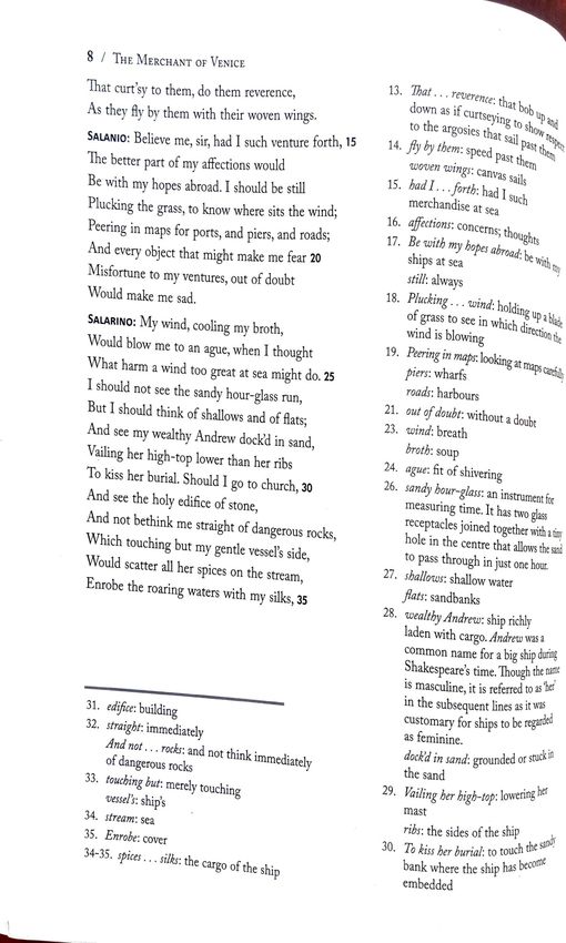
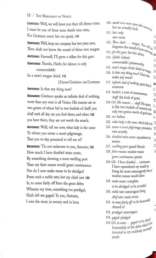
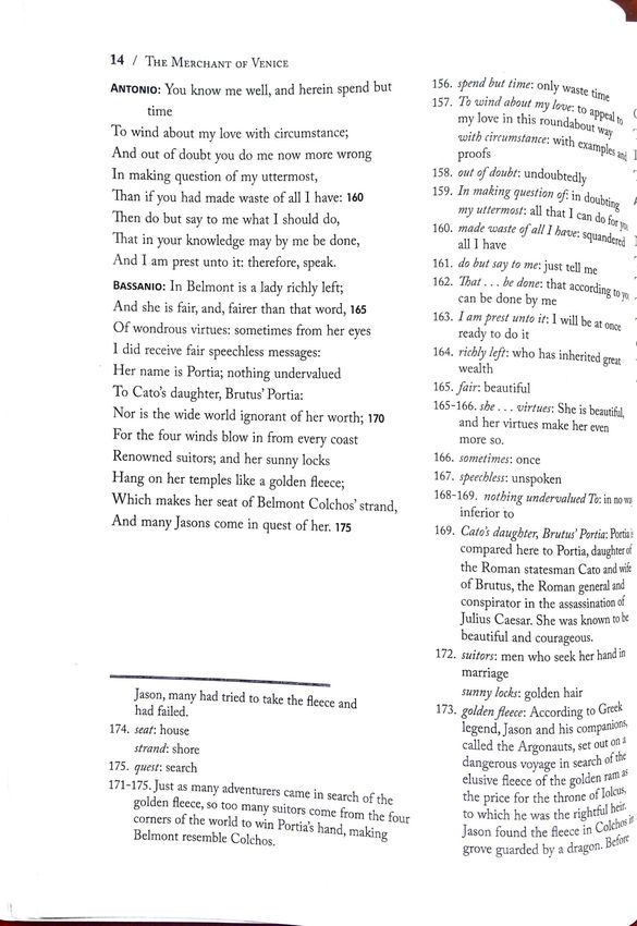
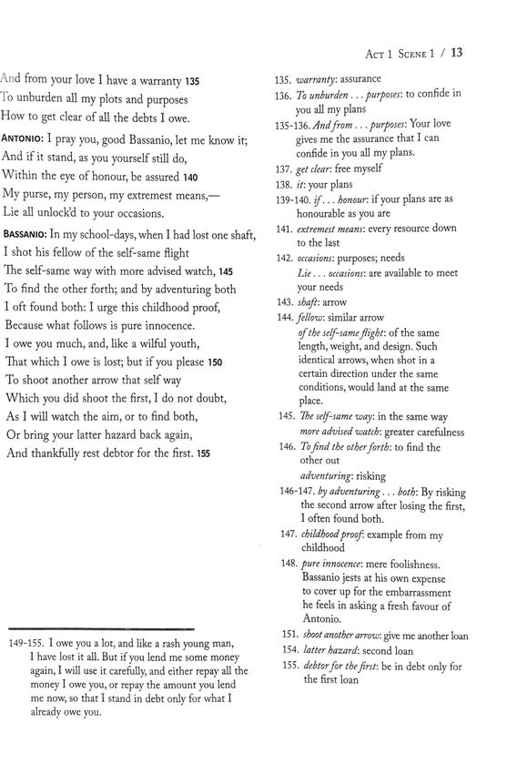
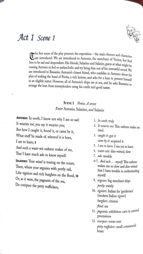
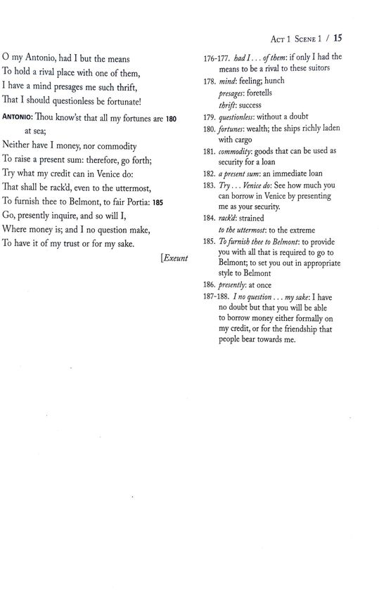
In the opening scene of “The Merchant of Venice” we find Antonio, a rich merchant, in a melancholic mood. Analyze
the probable causes for Antonio’s sadness with close reference to the conversation between Antonio, Salario and
Solanio. Later in the scene, what remarks does Gratiano make on Antonio’s mood?
Guidelines:
Salario’s suggestion regarding Antonio’s sadness.
Solanio’s suggestion regarding Antonio’s sadness.
Antonio brushes aside their reasons by giving his views.
Gratiano’s remark on Antonio’s mood.
Antonio’s views.
Answer either Question 2 or Question 3
Question 2
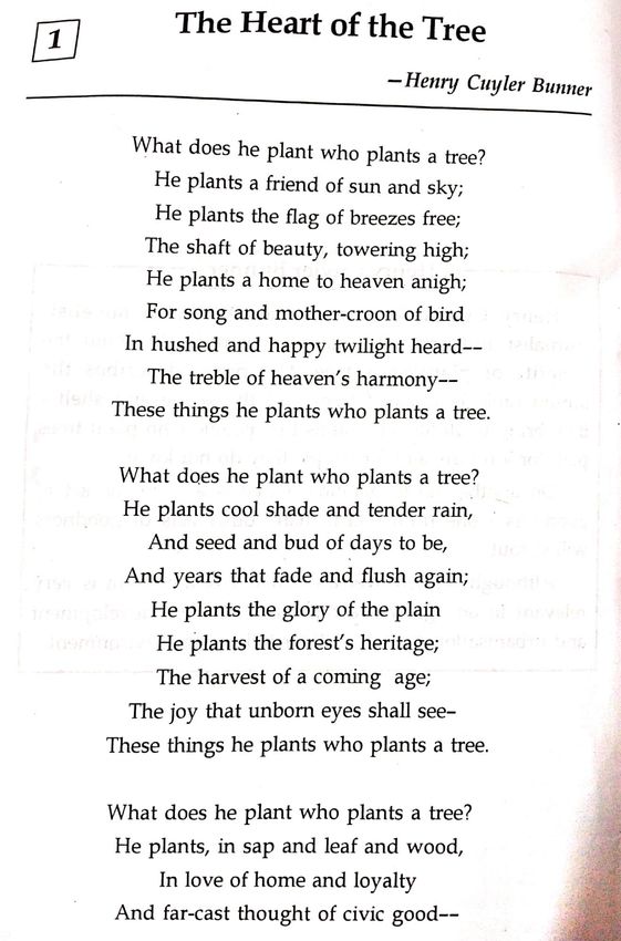
With a close reference to H.C. Bunner’s poem “The Heart of the Tree,” how does the poet justify that trees
contribute in a great way to the civic good?
Guidelines:
The importance of planting trees.
Plants are our true friends- provide us with cool breeze.
Plants are the embodiment of beauty.
Brings joy to all- birds, animals and human beings.
Plants cause rain, enrich our forests, provide food, help the country to progress.
Question 3
Discuss the setting of Ernest Hemingway’s short story “Old Man at the Bridge.” How far is the character of the old
man appropriate in such a setting?
Guidelines:
Pontoon Bridge, Easter, Ebro river, war zone.
Old man is a victim of war like others.
Had to leave his native place.
Leave his animals.
Uncertain future.
N.B. Assignment to be done in fair on file sheets.
Word limit for each assignment: 300- 350 words.

Project Work – Class IX, Session : 2020-2021
                                  (Students of Class VIII, 2019-2020)
                                         HCG-I (History & Civics)
                                                   Topic 1
                                     Knowing Our Fundamental Rights.
*Index
*Introduction- Defination and history of the implementation of Fundamental Rights.
* Main body- Six Fundamental Rights; clauses (any three of each) and importance.
* Conclusion- limitations and the way out.
*Acknowledgement.
*Bibliography.
                                                   Topic 2
                                    The City Life of Harappan Civilization
*Index
* Introduction- The history of discovery and the Important centres of the civilization.
Main body- The key features of city life i.e. Roads. Drainage System. Brick Houses. Great Bath. Great
Granary. Trade and Commerce.( 3 points from each)
* Conclusion- The real nature of the civilization and reasons for the decline.(any 3 points)
* Acknowledgement
*Bibliography

N.B : Complete both the topics in fair and bring to school when the school reopens.
Project Work – Class IX, Session : 2020-2021
(Students of Class VIII, 2019-2020)
HCG-II (Geography)
A record file having the following exercises will be maintained :
a) Uses of important types of maps. (2 pages)
Maps: A map is a symbolic representation of selected characteristics of a place, usually
drawn on a flat surface. Maps present information about the world in a simple, visual way.
They teach about the world by showing sizes and shapes of countries, locations of features,
and distances between places.
Types of maps:based on scale
Cadastral maps
Large scale maps mostly used in urban geography for town planning,revenue and other
administrative offices.
Topographical maps
Large scale maps to show natural and man-made feature of a place.
Based on small scale
Wall map
Small scale maps showing large area.
Atlas map
On the basis of subject matter
Physical
Maps showing relief features, drainage pattern etc.
Cultural
Maps showing cultural environment created by men and their activities.
Thematic
Portray special variation of single phenomenon or relationship between various
phenomena.
Mention about the significance of maps.
b) Directions and how to identify them -an illustrative diagram.
Geographic north and magnetic north :- Define both the terms and explain them with
diagrammes ( 1 to 2 pages).c) Drawing and recognising forms of important contours viz. valleys, ridges, types of
slopes, conical hill, plateau, escarpment and sea cliff.
V-shaped Valleys : It is shown by V-shaped contours the apex of which always points
upstream.
Ridges : Long narrow high land sloping steeply downwards on its side. Contours elongated
and closely spaced.
Type of slopes : Steep slope ,gentle slope , uniform slope, concave and convex slopes.
Conical hills : Broad base , circular in shape , peak is narrow. contours circular in shape.
Plateau : Elevated land of nearly level surface having steep sides. Contours elongated in
shape.
Escarpment : abrupt and comparatively long regular and regular steep face of a hill ridge or
plateau. Contours are very close but will not touch each other.
Sea Cliff : Very steep slope along river or lake. Two or more contours joint together.
Draw the contours and sectional diagram for each features mentioned above. ( each
page atleast two features )
.
d) Metrological Instruments and their uses-Six's maximum and minimum thermometer,
mercury barometer & aneroid barometer, wind vane, anemometer, rain gauge and
hygrometer.
Follow this pattern: each blank page 2 instrument along with their uses.
Six's maximum and minimum thermometer: Six's Maximum and Minimum
thermometer is a U shaped parallel tube made up of glass. One side registers
the maximum temperature and the other side records the minimum temperature. The
bend at the bottom of the thermometer contains mercury which moves up or down based
on the expansion and contraction of alcohol. Six's thermometer is used where when onewants to know the maximum or minimum temperature during a day. It indicates current temperature along with the highest and the lowest temperatures since it was last set. It is used to record extreme temperatures at a location as in meteorology, horticulture etc. Mercuary barometer : A barometer in which the weight of a column of mercury in a glass tube with a sealed top is balanced against that of the atmosphere pressing on an exposed cistern of mercury at the base of the mercury column, the height of the column varying with atmospheric pressure. It is a scientific instrument that is used to measure air pressure in a certain environment. Pressure tendency can forecast short term changes in the weather. Many measurements of air pressure are used within surface weather analysis to help find surface troughs, pressure systems and frontal boundaries. Aneroid barometer : An aneroid barometer is an instrument for measuring pressure as a method that does not involve liquid. Invented in 1844 by French scientist Lucien Vidi,the aneroid barometer uses
a small, flexible metal box called an aneroid cell (capsule), which is made from an alloy of
beryllium and copper.

Wind vane

A wind vane is a device that measures the direction of the wind. The wind vane is usually
combined with the anemometer. Wind direction is the direction from which the wind is
blowing.

Anemometer

An anemometer is a device used for measuring wind speed and direction. The term is
derived from the Greek word anemos, which means wind, and is used to describe any wind
speed instrument used in meteorology.
Rain guage:

A rain gauge (also known as an udometer, pluviometer, or an ombrometer) is an
instrument used by meteorologists and hydrologists to gather and measure the amount of
liquid precipitation over an area in a predefined period of time.

Hygrometer

 A hygrometer is an instrument used to measure the amount of humidity and water vapour
in the atmosphere, in soil, or in confined spaces.

N.B : To be completed in fair and brought to school when the school reopens.
You can also read