Proposal for development of a tool for mapping seagrass distribution in the NOWPAP region - nowpap cearac
←
→
Page content transcription
If your browser does not render page correctly, please read the page content below
UNEP/NOWPAP/CEARAC/FPM 15/12
                                                                                   Annex lX
                                                                                     Page 1

                        Proposal for development of a tool
              for mapping seagrass distribution in the NOWPAP region

1 Background
   In recent years, seagrass and seaweed in coastal areas have been given special attention in
terms of their potential for conservation of marine biodiversity and absorption of CO2. CEARAC
initiated its activities on mapping seagrass in the 2014-2015 biennium with development of a
manual for seagrass and seaweed beds distribution mapping with satellite images and conducted
case studies on mapping seagrass in the selected sea areas in the NOWPAP region for
evaluation of the developed manual. In the 2016-2017 biennium, CEARAC has been working on
feasibility study towards assessment of seagrass distribution in the NOWPAP region, in which
CEARAC envisions estimating seagrass distribution in the entire coastal seas of the NOWPAP
region in the future by using satellite images. Through the feasibility study, CEARAC identifies
obstacles and required future actions towards assessment of seagrass distribution in the
NOWPAP. By now, CEARAC with national experts has collected information to develop a
database of seagrass distribution and threats to seagrass in the NOWPAP member states by
reviewing literature in each NOWPAP member state.
   To review the progress of the feasibility study and discuss future actions for mapping seagrass
distribution in the NOWPAP region, the first international workshop on assessment of seagrass
distribution in the NOWPAP region was organized in Himi, Toyama, Japan on August 3, 2017.
During the workshop, consensus was formed towards assessment of seagrass in the whole
NOWPAP region: use of freely available satellite images; involvement of the public to collect field
survey information and map distribution of seagrass; and development of a tool using cloud
computing technology. Following this consensus, CEARAC proposes to develop a tool for
mapping distribution of seagrass in the NOWPAP region in the 2018-2019 biennium. This
proposal is in line with two priority themes of draft NOWPAP Medium-Term Strategy (MTS)
2018-2023 being prepared by NOWPAP RCU; assessment of the status of the marine and coastal
environment and conservation of marine and coastal biodiversity.
   CEARAC will submit this proposal to be reviewed at the 15th CEARAC Focal Points Meeting
(FPM) (Toyama, August 29-30, 2017) prior to the 22nd NOWPAP Intergovernmental Meeting
(IGM).

2 Objective
   Objective of this activity is to develop a tool for mapping and sharing information on distribution
of seagrass in the NOWPAP region by using satellite images. The developed assessment tool will
be shared among the NOWPAP member states to help mapping distribution of seagrass in each
member state. Depending on availability of external funding, CEARAC will develop a website that
                                               1
UNEP/NOWPAP/CEARAC/FPM 15/12
Annex lX
Page 2

incorporates the developed tool in it, so that users can detect distribution of seagrass in their
regions of interest by uploading their filed data.

3 Tasks
 3.1 Detection of potential seagrass habitat and collection of water depth information
      CEARAC will detect potential seagrass habitat in the NOWPAP region based on the result of
    literature review on seagrass distribution in the 2016-2017 biennium and information derived
    from satellite images. Information of water depth shallower than 20 m in the coastal areas of
    each NOWPAP member state will be collected by national experts nominated by CEARAC
    Focal Points, as it is helpful to correct effect of water column and mask deeper water. In case
    information of the water depth cannot be obtained, Bathymetry Mapper, a tool to estimate
    water depth from satellite images, will be used.

 3.2 Development of a tool for mapping seagrass distribution with satellite images
       When seagrass distribution is estimated based on satellite images, it usually takes a series
    of steps as shown in table 1: selecting and obtaining satellite images from spaces agencies,
    carrying out sea truth survey or collecting existing field data, preparing training data sets for
    classification, removing sun glint, correcting radiance by depth, classifying images and
    assessing accuracy of obtained classification results. This process indeed requires a person
    to have a profound knowledge on analysis of satellite images and it takes long time to map
    distribution of seagrass. In a case study in Nanao Bay, the steps and time in table 1 were
    taken to map distribution of seagrass with good quality, but it is quite unrealistic to take similar
    steps in the whole NOWPAP region.

                  Table 1 Steps and time taken for mapping distribution of seagarss
                                    in the case study of Nanao Bay
              Steps                                      Action                              Time
          Selection and         Visual screening of satellite images in the                 10 days
      download of satellite     database,    “Earthexplorer”      by   United   States
              images            Geological Survey (USGS) and downloading 417
                                GB of usable images         which have less clouds
                                and easier to recognize sea bottoms.
          Preprocessing         Making RGB images, adjusting brightness and                 5 days
                                correcting water columns in ENVI software
      Filed monitoring and      - Field monitoring with underwater video camera in          10 days
          preparation of        Nanao Bay: 3 days

                                                     2
UNEP/NOWPAP/CEARAC/FPM 15/12
Annex lX
Page 3
training dataset - Preparing a training dataset in GIS: 7 days
Image classification Classifying images based on the developed 10 days
and accuracy training dataset and assessing accuracy of the
assessment classified images in ENVI software
Towards assessment of seagrass in the whole NOWPAP region, use of freely available
satellite images, involvement of the public to collect field survey information and map
distribution of seagrass, and development of a tool using cloud computing technology are
expected. Thus, CEARAC proposes to develop a tool dedicated for mapping distribution of
seagrass with freely available satellite images. The proposed tool will be a standalone
software program that can carry out the following tasks:
a. Input user specified coordinates (row/path or latitude/longitude) for downloading Landsat
8 OLI and Sentinel 2 MSI satellite images from cloud server;
b. Apply radiance to reflectance calculation;
c. Use infrared data to identify land areas for masking;
d. Remove effect of sun glint;
e. Correct water column by Depth Invariant Index or Bottom Reflectance Index method;
f. Create true color images from Red, Green and Blue band;
g. Import training datasets in GIS format;
h. Test supervised and unsupervised machine learning methods to distinguish sea floor
substrates; and
i. Assess accuracy of the classified image against training dataset
CEARAC will subcontract the development of the tool to a private company.
3.3 Development of a website for mapping seagrass distribution with satellite images
CEARAC will incorporate the tool developed in 3.2 in a website and provide services to
users for mapping distribution of seagrass in their regions of interest using cloud computing
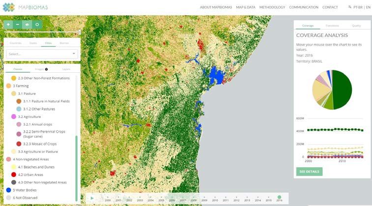
technology. Similar services are already realized in mapping terrestrial biomass and water.
‘MapBiomass’ project enables visualization of changes in land use / land cover in Brazil and
neighboring countries with time series of landsat data archive (Figure 1). This project involves
the various organization and the public to collect filed data and assess obtained classification
results. By using parallel data processing of cloud computing technology, user can map land
use / land cover changes at high speed and low cost.
3UNEP/NOWPAP/CEARAC/FPM 15/12
Annex lX
Page 4
Figure 1 Website of MapBIomass project.
http://mapbiomas.org/
Another example is “Global Surface Water Explorer” of European Commission. In this
website, changes in coastal areas can be visualized by identifying moisture of land surface
using time series of landsat data archive (Figure 2).
Figure 2. Temporal change of Land surface moisture around Jaouzohu Bay in Qingdao,
China shown in Global Surface Water Explorer (https://global-surface-water.appspot.com/).
Red areas are newly expanded lands created by landfills.
These websites are powered by Google Earth Engine, a planetary-scale for Earth science
data and analysis. It combines a multi-petabyte catalog of satellite imagery and geospatial
4UNEP/NOWPAP/CEARAC/FPM 15/12
Annex lX
Page 5
datasets with analysis capabilities and makes it available for scientists, researchers, and
developers to detect changes, map trends, and quantify differences on the Earth's surface.
Similar cloud services are also available from Amazon. Amazon Web Services know as AWS,
provides satellite data that can be used for mapping seagrass.
Since the development of the website using the cloud computing technology require
additional funding, CEARAC will prepare a proposal for development of the website for
obtaining funding from external sources. The task in 3.3. will be implemented if the funding is
secured.
4 Expected outcomes
By the developed/released web-based information in the NOWPAP region, various
stakeholders including governments, citizens, fisheries and/or politicians can share the same
knowledge of distribution of seagrass which can help cooperate each other to plan policies to
conserve and/or recover seagrass beds, and contribute to sustainable costal area management.
When the total area of seagrass beds in coastal areas is identified, the information is also used to
estimate the amounts of CO2 absorbed in the sea, which is useful for relevant researchers and
government officials in terms of mitigating global warming.
In addition, this activity can cooperate with a project of Ocean Remote Sensing in
IOC/WESTPAC, and can be applied in the Southeast Asian countries as well.
5 Schedule
The timeline of this activity is shown below.
Time Action Main body
2017 August Review of this proposal FP
at CEARAC
FPM15
December Review and approval of CEARAC IGM
at NOWPAP workplan and budget for 2018-2019
IGM22
2018 Q1 to Q3 Identification of potential seagrass habitat Nominated national
experts and
CEARAC
2018 Q4 Development of a tool for mapping CEARAC and
to 2019 Q3 seagrass distribution with satellite images consultant
2019
5UNEP/NOWPAP/CEARAC/FPM 15/12
Annex lX
Page 6
Q3 to Q4 Construction of web-based service for CEARAC and
mapping seagrass distribution consultant
6 Budget
To be Budget
Task Time Deliverables Main body
completed (US$)
Expert in China
5,000
-Map of potential sea
Detection of seagrass habitat Consultant in
2018 2018 5,000
potential seagrass - Depth information on Japan
Q1 Q3
habitat shallow waters (You can also read