REDD+ IN DRC: STATUS AND OPERATIONAL OPTIONS FOR THE DEVELOPMENT OF ALLOMETRIC EQUATIONS
←
→
Page content transcription
If your browser does not render page correctly, please read the page content below
REDD+ IN DRC: STATUS AND
   OPERATIONAL OPTIONS FOR THE
   DEVELOPMENT OF ALLOMETRIC
   EQUATIONS

   May 2017

This report is made possible by the support of the American people through the U.S. Agency for
International Development (USAID). The contents are the sole responsibility of the U.S. Department of
Agriculture Forest Service International Programs and do not necessarily reflect the views of USAID or the
U.S. Government.
Contributors to this report: Ministry of Environment and Sustainable Development
(MEDD), Democratic Republic of the Congo; Adrien Djomo, Consultant

Primary Forest Service Contacts:
Richard Paton
Central Africa & Middle East Regional Advisor
Forest Service International Programs
Office of the Chief
p: +1 202 294 0722
richardpaton@fs.fed.us

Olivia Freeman
DRC Country Coordinator and Central Africa Field Program Manager
Forest Service International Programs
Office of the Chief
c: +243 824 806 633
olivia.freeman@fs-ip.us

                                                                                   1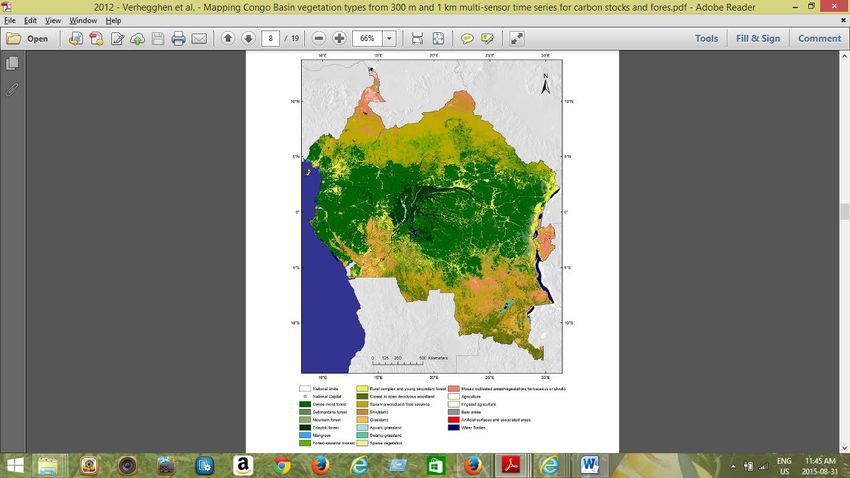
REDD+ IN DRC: STATUS AND
OPERATIONAL OPTIONS FOR THE
DEVELOPMENT OF ALLOMETRIC
EQUATIONS

May 2017

                              2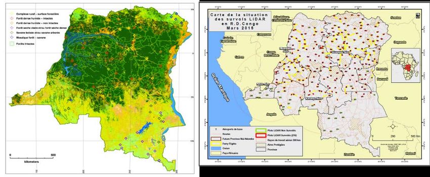
SUMMARY
In order to meet the requirements of the United Nations Framework Convention
on Climate Change (UNFCCC), the Democratic Republic of the Congo (DRC) has
set up a national REDD+ strategy that includes forest carbon inventory and a
methodology for monitoring, reporting and verification (MRV). To support this
process one tool needed to convert data from forest inventories into carbon
emission and sequestration estimates for the country is the use allometric equations.
Allometric equations allow for estimations of carbon storage within forests based
upon forest species composition and age. In general, species-specific allometric
equations for DRC are limited. Therefore, MEDD with the financial support from
United States Agency for International Development (USAID) and facilitation by the
United States Forest Service (USFS) produced this status report on allometric
equations in the DRC to inform the current state of knowledge and next steps.
A two-phase study was conducted in Kinshasa and in the field from August to
December 2015. This study involved meeting with the main actors involved in the
REDD+ process and assessing use of allometric equations to estimate carbon stocks
in DRC. A national workshop was held in Kinshasa from the 16th to the 17th of
December 2015 to validate operational options identified in the study for allometric
equation development in the DRC. Two phases to develop allometric equations
were identified and recommended:
− First phase: data from local allometric equations are harmonized with equations
  from the sub-region to develop new allometric equations.
− Second phase: field data collection in five forests stratas to develop allometric
  equations which are specific for various types of forests in the DRC.
Five strata were selected for the development of these new equations, consistent
with the Forest Reference Emission Levels/Forest Reference Levels (FRELs/FRLs)
methodology. A budget for this study was proposed as guidelines to help mobilize
funds required to implement recommendations.

                                                                                      3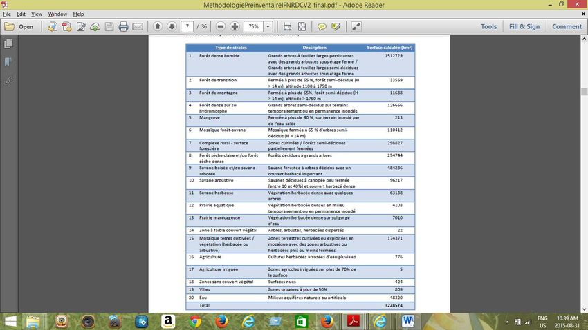
TABLE OF CONTENTS
Summary ......................................................................................................................................... 3
Table of contents ......................................................................................................................... 4
List of Figures ................................................................................................................................ 5
List of Tables ................................................................................................................................. 6
Acronyms ....................................................................................................................................... 7
I    Introduction ............................................................................................................................. 9
     I.1     Background and Rationale ............................................................................................ 9
     I.2     Objectives and expected results................................................................................. 9
     I.3     Study phases .................................................................................................................. 10
II    Sub-regional context ........................................................................................................... 10
     II.1     PRREDD+ / COMIFAC ............................................................................................. 10
     II.2     Status of forests in the Congo Basin ...................................................................... 11
III Procedure of the study and main actors involved in the REDD+ process in the
DRC .............................................................................................................................................. 12
     III.1      Activities of organizations that were consulted during this study ................. 14
     III.2      Key academic institutions conducting forest research in the DRC .............. 17
IV     Description of forest ecosystems in the DRC............................................................ 19
     IV.1       Phytogeographic Description ................................................................................. 19
     IV.2       DRC Forest Stratification ....................................................................................... 20
     IV.3       Pre-National Forestry Inventory (Pre-NFI) and other inventories ............... 23
     IV.4       Permanent plots in the DRC .................................................................................. 24
     IV.5       Other inventories in the DRC ............................................................................... 25
V      Status of Research and Development of allometric equations in the DRC .......... 26
     V.1      Case of dense and moist forests............................................................................. 26
     V.2      Case of the Miombo area ......................................................................................... 27
VI     GHG – Emission factors – Reference level ................................................................. 28
     VI.1       Greenhouse gas and emission factors in the DRC ........................................... 28
     VI.2       Reference levels ........................................................................................................ 28
VII National workshop to validate operational options for equations development
in the DRC ................................................................................................................................... 29
     VII.1       Implementation of activities .................................................................................. 31
     VII.2       Recommendations ................................................................................................... 32
     VII.3       The DRC roadmap toward developing allometric equations ....................... 33
References ................................................................................................................................... 36
Annexes ........................................................................................................................................ 38

                                                                                                                                                  4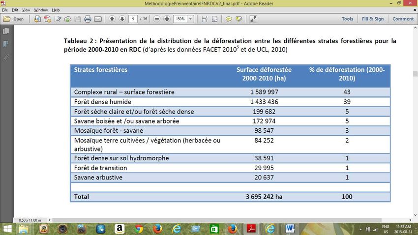
LIST OF FIGURES
Figure 1: Forests of the Congo Basin .................................................................................... 12
Figure 2: Old and new administrative division of provinces............................................. 19
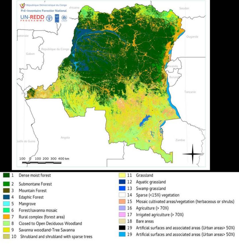
Figure 3: Map of forest stratification the DRC (Source: Verhegghen et al, 2012). ..... 21
Figure 4: Types of pre-NFI plots (Source: MECNT, 2012). ............................................. 24
Figure 5: Pre-NFI plots location maps (Source: MECNT, 2012) and LIDAR over flight
done by the SMC (Southern Mapping Company). .............................................................. 24
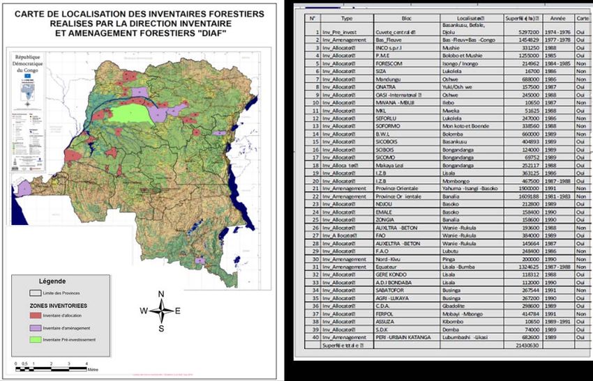
Figure 6: Left, map showing the various types of allocation, pre-investment and
management inventories of the DRC. Right, details on inventory types (type,
location, land area and year of completion). Period: 1974 – 1991. ................................ 25
Figure 7: Map showing the main countries covered by the Miombo forest stratum. 28
5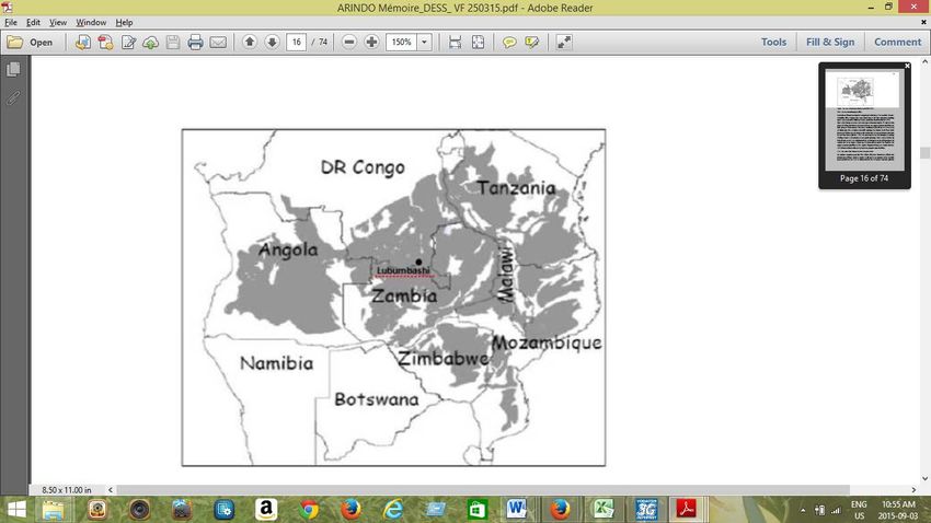
LIST OF TABLES
Table 1: Description and estimation of the extent of forest strata DRC (Source:
Verhegghen et al, 2012). ........................................................................................................... 22
Table 2: Assessment of deforestation in the DRC during 2000 to 2010 period
(Source: UN-REDD / FAO, 2012; from the data from OSFAC, FACET and
Verhegghen et al, 2012). ........................................................................................................... 23
Table 3: Plots planned and done as part of the pre-NFI. .................................................. 23
Table 4: Distribution of permanent plots in various DRC former provinces. ............. 25
Table 5: Various types of equations developed in Central Africa, including pan-
tropical equations ....................................................................................................................... 27
Table 6: Schedule of activities for Phase 1 ........................................................................... 34
Table 7: Schedule of activities for Phase 2. .......................................................................... 35
Table 8: Budget for Phase 1. .................................................................................................... 35
Table 9: Budget for Phase 2. .................................................................................................... 35

                                                                                                                                           6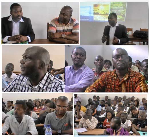
ACRONYMS
AFODEK     Agroforêts pour le développement de Kipushi
ALOS       Advanced Land Observation Satellite
BMU        Federal Ministry for the Environment, Nature Conservation,
           Building and Nuclear Safety, Germany
CA         Central Africa
CAFEC      Central Africa Forest Ecosystems Conservation
CARPE      Central Africa Regional Program for the Environment
CAVRE      Contrat Achat-Vente des Réductions d’Emissions
CFT        Compagnie Forestière de Transformation
CIFOR      Center for International Forestry Research
CN-REDD    National Coordination of REDD
COMIFAC    Commission of Central Africa Forests
COP        Conference of Parties
DDD        Directorate of Sustainable Development
DIAF       Directorate of Forest Inventory and Management
ERA        Ecosystem Restoration Associates
ERAIFT     Regional School for Tropical Forest and Territories
           Management
FACET      Forêts d’Afrique centrale évaluées par Télédétection
FAO        Food and Agriculture Organization of the United Nations
FCCC       Forest and Climate Change in Congo
FIB        Fédération des Industriels du Bois
FREL/FRL   Forest reference emission levels/Forest reference levels
FRM        Forêt Ressources Management
GEF        Global Environment Facility
GHG        Greenhouse Gas
INERA      Institut National pour l'Etude et la Recherche Agronomiques
IPCC       Intergovernmental Panel on Climate Change
ISEA       Institut Supérieur d’Études Agronomiques – Bengamisa
JAFTA      Japan Forest Technical Association
JICA       Japanese International Cooperation Agency

                                                                         7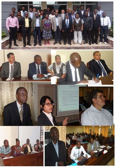
KfW       German Development Bank
LECAFOR   Laboratoire d’Ecologie et d’Aménagement Forestier
LIDAR     Light Detection and Ranging
MEDD      Ministry of Environment and Sustainable Development
MERIS     Medium Resolution Imaging Spectrometer
MODIS     Moderate Resolution Imaging Spectroradiometer
MRV       Monitoring, Reporting and Verification
NFI       National Forest Inventory
NGO       Non-Governmental Organization
NOVACEL   Nouvelle Société d'Agriculture et d'Elevage
OCEAN     Organisation Concertée des Ecologistes et Amis de la Nature
ONFI      Office National des Forêts International
OSFAC     Central African Forests Satellite Observatory
REDD      Reduction of Emission from Deforestation and forest
          Degradation
SFM       Sustainable Forest Management
SMC       Southern Mapping Company
SNSF      National Forest Surveillance System
SODEFOR   Société de Développement forestière
SPIAF     Service Permanent d'Inventaire et d'Aménagement Forestiers
UCB       Catholic University of Bukavu
UCL       Catholic University of Louvain
UNFCCC    United Nations Framework Convention on Climate Change
UNIKIN    University of Kinshasa
UNIKIS    University of Kisangani
UNILU     University of Lubumbashi
UNITAR    United Nations Institute for Training and Research
UN-REDD   United Nations REDD
USAID     United States Agency for International Development
USFS      United States Forest Service
WCS       Wildlife Conservation Society
WWC       Wildlife Works Carbon
WWF       World Wildlife Fund for Nature

                                                                        8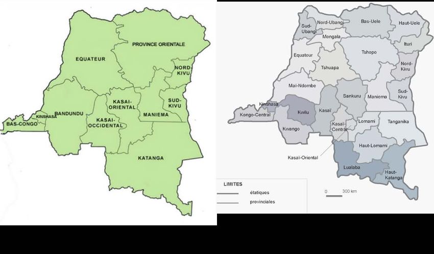
I INTRODUCTION
I.1 Background and Rationale
To meet the requirements of the United Nations Framework Convention on
Climate Change (UNFCCC), countries wishing to participate in REDD+ must have a
thorough knowledge of the carbon stock in their national territory and the ability to
monitor these stocks within time and space. DRC has a clear national REDD+
strategy that include a forest carbon inventory and a monitoring methodology,
reporting and verification (MRV) implemented by the Directorate of Forest
Inventory and Management (DIAF) within the Ministry of Environment and
Sustainable Development (MEDD). The Directorate of Sustainable Development
(DDD) has the mandate from the MEDD to work with DIAF for compiling data
collected during the national forest inventory and other carbon measurement
inventories to convert this data into estimates of emission or carbon sequestration
in the country. These conversions are done by using allometric equations.
The development of allometric equations is time-consuming and labor intensive.
Allometric equations are statistical formulas determining the relationship between
biomass, measurable volume and parameters directly or indirectly in the field such as
the diameter or the height of the trees. Allometric equations in Central Africa are
still insufficient, and even less so in the DRC. In this context, the pan-tropical
allometric equations were used to assess carbon stocks in tropical forests in the
absence of specific allometric for the site. Depending on the degree of precision that
DRC wishes to have in assessing their biomass and forests carbon, specific equations
for the DRC could be developed and used possibly in combination with pan-tropical
regional or local equations.
The allometric equations specific to the site or the combination of equations that the
DRC should use for estimating carbon stock and flows, have not adequately been
studied or analyzed. As part of its technical assistance to MECDD, the United States
Forest Service (USFS) proposed to offer the services of a technical expert to work
with the focal points within DIAF and DDD, in coordination with the CN-REDD, to
assess the situation in DRC and to propose options for allometric equations to be
used and developed.

I.2 Objectives and expected results
The main objective of this work is to provide assistance to DIAF and DDD. Thus,
this study will allow to:
− Assess and document the actual availability of pan-tropical regional or local
  allometric equations relevant for the DRC;
− Analyze the REDD+ strategy for DRC and the forest carbon inventory
  methodology so as to better understanding the requirements for allometric
  equations;

                                                                                     9
− Undertake some case studies in similar countries on their approaches for using
allometric equations and data;
− Produce an analysis of the differences due to the absence of specific allometric
equations for the DRC reference levels;
− Determine scenarios on the use of equations and the development of new
equations to achieve the desired levels for the DRC;
− Organize a national workshop to restore and validate scenarios and develop an
action plan for the implementation of the resolutions;
− Wherever possible, support DIAF and DDD for the advancement of knowledge
and the development of forests reference emission levels / forest reference
levels.
I.3 Study phases
This study is organized in two phases:
Phase 1: This phase, carried out during a two-week mission in August-September
2015, helped to develop the methodology to be adopted for the study, to identify
the main actors to be consulted and to meet with actors in based in Kinshasa to
assess activities carried out as part of allometric equations and/or carbon stock
estimates.
Phase 2: This phase was originally scheduled to take place between September -
November 2015 to also facilitate the DRC REDD+ readiness plan for the UNFCCC
Conference of the Parties 21(COP 21), held from November 30 to December 21,
2015. To facilitate readiness for COP 21, the consultant made available to national
experts a document to be used as technical support for negotiations. A national
validation workshop connecting regional and national-based actors reviewed
recommendations and analyzed the feasibility of developing allometric equations in
the DRC in the coming years.
II SUB-REGIONAL CONTEXT
II.1 PRREDD+ / COMIFAC
The REDD+ (Reducing Emissions from Deforestation and Forest Degradation)
Institutional Capacity Building Project for the sustainable management of forests
(SFM) in the Congo Basin (hereinafter referred to as PRREDD+ Regional Project),
received a GEF funding of $13 million US Dollars managed by the World Bank and
implemented by the Commission of Central African Forests (COMIFAC). This five-
year project will:
− Improve knowledge and coordination on REDD+ issues in the Congo Basin;
− Strengthen technical capacity for the measurement and monitoring of carbon
stocks in the Congo Basin forests;
10− Help mainstream REDD+ concept in SFM projects.
The six countries with the highest forest density in the Congo Basin (Cameroon,
Central African Republic, Democratic Republic of Congo, Equatorial Guinea, Gabon
and Republic of Congo) have all committed to ensure regional coordination of
efforts for conservation and sustainable management of Central African forests.
COMIFAC, which was established in 2005 as a regional political and technical
authority responsible for guiding, monitoring and coordinating SFM in Central Africa,
is the coordinator of this effort. The COMIFAC Executive Secretariat is responsible
for overseeing and coordinating the implementation of the Regional REDD+ project
with the support of a PRREDD+ technical unit project.
The six countries of the Congo Basin have undertaken efforts to develop national
mechanisms for REDD+. As members of the United Nations Framework
Convention on Climate Change (UNFCCC), countries have recognized the need for
participating in the design and the implementation of actions aiming at reducing
emissions from deforestation, sustainable forest management, improving carbon
stock estimates and following up the recommendations of the Bali Action Plan of the
UNFCCC COP13 in 2007.
II.2 Status of forests in the Congo Basin
The Congo Basin is the central Africa region comprising the following six countries:
Cameroon, Central African Republic, Democratic Republic of the Congo, Republic
of Congo, Equatorial Guinea and Gabon. The Congo Basin covers an area of 530
million hectares of which 300 million (Figure 1) are covered by forests (Megevand
2013). Industrial logging is practiced on about 44 million hectares of forests allocated
under logging concession representing 8.3% of the total area and 14.7% of the
forests of the Congo Basin (Megevand 2013; de Wasseige et al. 2012).
Logging is selective to maintain a permanent forest cover. These forests are home to
a great diversity of plant and animal species and provide valuable ecosystem services
at local, regional and global levels. More specially, these forests provide livelihoods to
nearly 60 million people who live there and almost 40 million people living in urban
centers near these forests (Nasi et al., 2010). Overall, the forests of the Congo Basin
represent about 25% of carbon stored in tropical forests worldwide, and are
therefore an important source for mitigation of anthropogenic emissions (de
Wasseige et al. 2012).
Since the forests of the Congo Basin have an impact on the quality of life of the local
people, and people at the regional and global levels, mapping and monitoring of
changes and/or disruption of these forests are of great importance. It is important to
gain knowledge of its area, its floristic composition, the growth dynamics and
environmental factors that influence these forests and the various types of
disturbance for the implementation of environmental and economic policies,
particularly in the context of REDD+ (de Wasseige et al. 2012).
11Figure 1: Forests of the Congo Basin
III PROCEDURE OF THE STUDY AND MAIN
ACTORS INVOLVED IN THE REDD+
PROCESS IN THE DRC
In the DRC, various ministerial institutions and private organizations or national and
international NGOs are involved in the REDD+ process. According to an expert
within CN-REDD in DRC, 17 ministries were involved in the REDD+ process as
well as many organizations. The meeting with USFS and DIAF and its technical
partners such as JICA/JAFTA, FAO/UN-REDD has helped explain the Terms of
Reference, the objectives of the study, to understand the expectations and
determine the list and the schedule of organizations to be visited. To maximize
consultation, organizations based in Kinshasa and its surroundings as well as
Kisangani were selected. This was justified by the fact that most large organizations
that operate within the country are based in Kinshasa, the capital city. Kisangani was
also chosen for the study as there are ongoing relevant studies on biomass sampling
12as well as a REDD project coordinated by the University of Kisangani. Below are a
list and a description of organizations which were consulted as part of this study:
− Government institutions (DIAF, DDD, CN-REDD)
− Multilateral Development Institutions (FAO/UN-REDD)
− National and international NGOs (WWF, WCS, NOVACEL, JICA/JAFTA,
WWC, Nature Plus, OSFAC, OCEAN)
− Universities or university organizations (UNIKIN, ERAIFT, UNIKIS, IFA-
Yangambi, ISEA Kisangani)
− Trade and Union associations and logging companies’ forestry (FIB, SODEFOR,
CFT)
− Consultant firms (FRM)
During the first phase of the study, 11 of the 19 selected organizations were
consulted. They are: DIAF, DDD, CN-REDD, FAO/UN-REDD, WWF, WCS,
JICA/JAFTA, Nature Plus, OSFAC, ERAIFT and SODEFOR. Out of 8 organizations
that could not be consulted, 5 are located outside Kinshasa (UNIKIS, IFA-Yangambi,
OCEAN, ISEA, NOVACEL, ONFI) and it was agreed that those organizations should
be consulted during the second phase of the study. It was not possible to confirm
the appointment with Wildlife Works Carbon (WWC), the Head of the Forest
Department of UNIKIN; FIB was removed from the schedule. Therefore during the
second phase of the study, we traveled to Kisangani where we had two working
sessions with research teams which are conducting extended studies on biomass and
REDD+ extended studies at UNIKIS as well as with the representatives of the
following organizations: IFA-Yangambi OCEAN/Kisangani UNIKIS/ISEA. We also
gave a lecture open to all interested UNIKIS students and researchers in the region
with the theme: “Climate Change: issues, solutions and Opportunities for CA and
DRC.” We also had individual meetings with students to better understand their
research topics, the links with REDD+ issues and allometric equations.
Meetings with organizations were mostly in the form of group and/or individual
meetings. A brief description of activities carried out by these organizations within
the framework of REDD + process is presented below.
13Photo 1: A number of researchers and participants in the REDD + lecture at
UNIKIS.
III.1 Activities of organizations that were consulted during this
study
DIAF
DIAF (Directorate of Forestry Inventory and Management) is the directorate of the
MEDD (Ministry of Environment and Sustainable Development) responsible for the
national inventory and other inventories of forest resources. It is also responsible for
monitoring all types of forest inventory conducted by logging companies,
international NGOs and multilateral organizations. In collaboration with FAO / UN-
REDD, DIAF is conducting a Pre-National Forest Inventory (NFI) that will cover the
whole country.
FAO / UN-REDD
The FAO / UN-REDD is supporting DIAF in carrying out the Pre-National Forest
Inventory and in determining the methodology. It provides assistance for forest
stratification, for the development of methodology for pre-NFI and NFI and It is
working with DIAF staff for the implementation of this methodology. About 60% of
plots planned for the pre-INFI have already been covered.
14JICA / JAFTA
JICA /JAFTA is supporting three main REDD+ related activities of the MEDD:
− Remote sensing: forest maps of 1995, 2000, 2010 and 2014 were developed using
Landsat images. ALOS and SPOT high-resolution satellite images were produced
for Bandundu, Equateur and Orientale Provinces. The aim is to use these maps
to assess changes in forest cover and to determine the reference levels.
− Forest Inventory: A forest inventory is been conducted in Bandundu with
technicians from DIAF. In this context, one portion of pre-NFI plots was used
for collaboration and alignment of data. This forest inventory will help to
calibrate the reference levels for the whole country.
− GIS and database: There is no development plan for allometric equations in this
project. All data are stored in the database and the aim is to use adopted
allometric equations to produce the biomass estimate and to contribute toward
determining the reference levels.
JICA/JAFTA compared the existing allometric equations Chave et al. (2005), Chave
et al. (2014), Djomo et al. (2010), Fayolle et al. (2013) and SPIAF with the IPCC and
FAO expansion factor. They found that Djomo et al. (2010), Fayolle et al. (2013) and
Chave et al. (2005) came up with very close results.
DDD
DDD (Directorate for Sustainable Development) is the directorate of MEDD in
charge of conducting greenhouse gas inventories the country. This inventory involves
five main sectors which are energy, agriculture, industry, land use change, forestry,
and waste. This branch is responsible for using stocks reported by all sectors and
emission factors to determine past and present emissions of the country based on
the emission reference levels and adopted reference levels. At the moment there is
no specific emission factors as yet and no methodology for coming up with emission
reference levels or reference levels.
CN-REDD
The CN-REDD is the national coordination all REDD+ activities in the country.
Currently, it is developing a national REDD + program that will help to mainstream a
number of ministries and all major organizations implementing REDD+ activities in
the DRC.
WWF
As part of the “REDD for People and Nature’’, WWF has developed a project for
estimating carbon stock in a secondary forest in Malebo village in Bandundu
Province. They used Chave (2005) and Peasrson and Brown (2005) equations for
estimating biomass. Jean-François Bastin used high resolution images with field data
over 400 km2 in Malebo to produce a biomass map using the Chave et al. 2005
(Bastin et al. 2014) allometric equation. WWF under the Central Africa Forest
15Ecosystems Conservation (CAFEC) project under the USAID funded Central Africa
Regional Program for the Environment (CARPE) has developed a plantation and
agro-forestry project for the sustainable management of firewood. The project
would like to have specific allometric equations for biomass estimating. The aim of
the Carbon Mapping and Model project is to produce a national scale biomass map.
OSFAC
OSFAC (Central African Forests Satellite Observatory) in partnership with the
University of Maryland, carries out the monitoring of the Congo Basin forests and
produces satellite images that are used by different actors. They also use data to
monitor deforestation and collaborated with WWF in the Carbon Map and Model
project. Thus within the framework of the Carbon Mapping and Model project, 246
plots were spread across the country and LiDAR (Light Detection and Ranging)
images were taken by SMC (Southern Mapping Company). Some of these plots are
juxtaposed with those of the NFI, therefore, data from these plots will be used to
calibrate LIDAR results.
Carbon Mapping and Model Project
This 6 million euros project financed by KfW and BMU is run by WWF (Germany
and DRC) in partnership with DIAF, DDD and other national and international
partners (SMC OSFAC, CNREDD, FAO, WCS, UCL, OSFAC, JICA, etc.). Its aim is:
− to produce a national-scale biomass map for the entire DRC forest;
− to conduct feasibility studies for various forest protection measures as part of a
REDD+ project model.
Thus, this national-scale biomass map for the DRC will help assess carbon stocks and
emissions from the largest forest of the Congo Basin to support the national REDD
strategy, which plays a major role in the sustainable development and poverty
reduction. This map will be developed from field data, supplemented with LIDAR for
accurate estimation of carbon stocks in all wooded areas.
Nature Plus
Nature Plus has developed the Ntsio and AFODEK projects with the funding
received from the European Union. The Ntsio project located at 180 km away of
Kinshasa in the “Plateau des Batéké” is an agro-forestry project with the aim of
planting 3.93 million trees for carbon credits. The AFODEK project in Kipushi near
Lubumbashi, in Katanga has developed another agro-forestry project over 2,000
hectares. As part of this project, Nature Plus worked together with ERAIFT to
develop a local allometric equation for estimating the biomass of this project.
WCS
WCS in Ituri province has two sites where permanent plots have been measured for
25 years to assess the dynamics of forests and carbon stocks. In Salonga National
Park, there are also permanent plots in place from 8 to 10 years. The plots are 100
16m x 100 m and WWF LiDAR survey covered some of these plots which will be used
to calibrate the results and to contribute to the national carbon mapping. WCS is
interested in specific allometric equations, but has not yet had the opportunity to
produce or to contribute to its development. A PhD student from UCL who works
with WCS reviewed the existing equations and used them for biomass estimates. In
Bukavu, there is another project on forest conservation. There is also a REDD
project in the OYO mountain near Goma. The aim of this project is to develop
agro-forestry for biomass estimation and sustainable development.
SODEFOR
SODEFOR is a logging company in the DRC, which has 16 forest concessions in
three provinces representing 1.8 million hectares. The company worked with the
FORAFAMA Project with is a REDD + pilot project. The company has agreed in
principle to cooperate in case new allometric equations are to be developed, and
they are waiting to be informed on recommendations on that study.
III.2 Key academic institutions conducting forest research in the
DRC
UNIKIS
Establish in 1963, the university was successively known as: Free University of the
Congo (1963), National University of Zaire / Kisangani Campus (1971) and finally
University of Kisangani (1981). It stretches over on an area of approximately 132
hectares and has 8 faculties. The Faculty of Science and renewable natural resources
has:
− Several Laboratories and forest reserves (Yoko, Masako, Umba, Mbiye Islands,
etc.). One of these laboratories (LECAFOR) has the mandate to carry out on
behalf of COMIFAC / PRREDD /DRC the destructive data collection to develop
allometric equations in a transition rain forest within one CFT concession forest.
The start of these works has been delayed in reason of equipment delivery. The
works are due to start in the course of the year 2016.
− A Biodiversity Monitoring Center (CSB)
− The CIFOR FCCC project (Forest and Climate Change in Congo).
UNIKIN
Establish in 1954 under the name of Lovanium University. It became University of
Kinshasa in 1981. The university covers 400 ha and has over 26,000 students, 12
faculties and 6 schools. Initially forestry research was carried out in the Faculty of
Science and since 2008 the Forestry Department was established within the Faculty
of Agriculture and is supported by the University of Laval, Canada.
17ERAIFT
ERAIFT is the Regional University College based in Kinshasa which has MSc and Phd
programs. The MSc program takes 18 months and combines 10 months theoretical
study with a 2-month field study and a 6 month thesis. Since 2011, the main theme of
the program is REDD. A MSc student worked with AFODEK to develop a specific
allometric equation in Miombo forest within the vicinity of Lubumbashi.
IFA-Yangambi
College of Agricultural Sciences of Yangambi was established in 1972 with the aim of
training technicians and engineers in forestry and agronomy.
ISEA/Bengamisa
The ISEA of Bengamisa was established in 1969 in order to train A1 level executives
in the fields of forestry and agriculture. Thus, the mission of this school is to:
− Train senior executives (technicians, engineers), in the area of water and forests
for rational exploitation and technicians management of the DRC forest
resources; train also agricultural extension technicians for introducing new
techniques in the Congolese rural areas.
− Offer training in water and forestry, general agriculture and rural development;
− Supervise students during field work: forest inventory, reforestation techniques,
guided tours, extension service, agriculture, livestock.
INERA
Between1935-1945 an arboretum was planted using various silviculture techniques.
The institute has:
− tree herbarium in Yangambi with 24,937 samples including 111 families of 2,554
species, 10,576 beds of flowers and fruits and 1,014 xylotheque boards;
− two main centers (Yangambi and Luki) with two respective biosphere reserves
and five stations Bambesa, Mulungu, Kipopo, Nioka and M’Vuazi.
Currently, the institute needs rehabilitation to make available data on forest
dynamics, the behavior of plant species, etc.
UNILU
The University of Lubumbashi (UNILU) is a public university located in the city of
Lubumbashi, in the province of Katanga. Founded in 1955 as the official University of
Congo and Rwanda-Urundi, it went through several name changes including
Elisabethville State University (1960), official University of Congo (1963), National
University of Congo / Lubumbashi Campus (1971), National University of Zaire /
Lubumbashi Campus (1972) and from 1981 onward, University of Lubumbashi. In
2015, it had 20,438 students in 15 faculties and graduate schools and 1,198 members
of the teaching staff. Forest research takes place in the Faculty of Agriculture.
Created during 1995-1996 academic year as Department of Agricultural Sciences
18within the Faculty of Science, the department became Faculty of Agricultural
Sciences in 1998. The Faculty mission is to train competent agricultural engineers to
address issues of food production and sustainable land management and the
environment.
Université Catholique de BUKAVU (UCB)
UCB is a private university founded by the Catholic Church in 1989 with the status
of private higher learning Institution. It officially started admitting students in 1990.
To date, it consists of 5 faculties, aronomy, law, medicine, economy and management
sciences, and has 4 campuses and an enrolment of about 2,600 students. Forest
research takes place within the Faculty of Agricultural Sciences within two mayors:
crop science and soil science.
IV DESCRIPTION OF FOREST ECOSYSTEMS
IN THE DRC
IV.1 Phytogeographic Description
The Democratic Republic of Congo (DRC) covers a land area of 2,345,000 km² and
lies between latitudes 5 ° 20 'N and 13 ° 17' S and longitude 12 ° 15 'E and 31 ° 15' E
of Greenwich. With the recent administrative subdivision, the country changed from
10 to 26 provinces.
Figure 2: Old and new administrative division of provinces
The relief is dominated by various levels of plateau with a large depression in the
center known as the central basin, which is the main collection of more than 80% of
the water bodies of the Congo River tributaries. The Congo River which is the
second largest river in the world after the Amazon has its sources in the southern
tip of Katanga province, flows down through the former Kivu Province, passes by
Kisangani, Mbandaka and Kinshasa and runs into the Atlantic Ocean. It has a 3.65
19million square kilometers water catchment, an average flow of 45,000 cubic
kilometers of water per second at its mouth in the Atlantic Ocean. The central basin
has an average altitude of 400 m. In the north there are plains and plateaus with
altitudes ranging from 600 m to 1,000 m. Areas with altitudes between 1,000 and
1,600 m are located in the southern part of the country. In the East along the
Graben, are the Virunga mountains with an altitude of 4,500 m and the Ruwenzori
mountains 5,119 m above the sea level (MEDD - UNITAR 2006). Three climate
zones occur in the DRC. They are:
− The equatorial zone located at 2 degrees north and south latitude;
− The tropical zone located north and south of the equatorial zone;
− The relatively temperate zone in the far east.
IV.2 DRC Forest Stratification
Over the past decade, several assessment of the forest cover have been developed
from satellite images. These include:
− The land use map at with a 300 m resolution (MERIS image) produced in 2006
(GLOBCOVER initiative);
− Map covering Africa with a 1 km resolution, in the framework of the Global Land
Cover 2000 (GLC 2000);
− Vegetation map of the DRC with a 1 km resolution using SPOT images taken in
2009 (Vancutsem et al., 2009);
− Binary forest/no forest study from MODIS (between 250 m and 1 km resolution
depending on the spectral bands) and Landsat (15 m and 30 m resolution
depending on the spectral bands), done in 2008.
− Vegetation map from a combination of MERIS and SPOT data with a 300 m
accuracy (Verhegghen et al, 2012.). Recent studies including the pre-Inventory
(NFI: National Forest Inventory) are based on this map (Figure 3) which covers
all the forests of Central Africa (Figure 1).
20Figure 3: Map of forest stratification the DRC (Source: Verhegghen et al, 2012).
The study by Verhegghen et al. (2012) was used to estimate the extent of each
forest strata DRC (Table 1).
21Table 1: Description and estimation of the extent of forest strata DRC (Source:
Verhegghen et al, 2012).
The recent work by OSFAC (Satellite Observatory of Central African Forests) done
as part of the activity of the Central Africa Forest Assessed by Remote Sensing
(FACET), made it possible to determine the extent of deforestation and the main
strata involved (Table 2).
22Table 2: Assessment of deforestation in the DRC during 2000 to 2010 period
(Source: UN-REDD / FAO, 2012; from the data from OSFAC, FACET and
Verhegghen et al, 2012).
IV.3 Pre-National Forestry Inventory (Pre-NFI) and other
inventories
DIAF in partnership with FAO has developed a methodology for pre-NFI (MECNT,
2012). To carry out this national forest inventory 65 plots nested square shapes or
inverted L using sub circular plots (Figure 4) were selected. Table 3 below provides a
break down by province of the numbers of plots planned and done as well as the
forms of plots used.
At the time this report was written, DIAF sent teams to the field to complete
inventories in the following sites: Kasai Oriental, Maniema and Orientale Province.
For security reasons, inventories cannot continue in Katanga, South and North Kivu.
However, the pre-NFI should allow for better national coverage and also for
planning for further measurement campaigns to get national forest inventories with a
better representation of the sampling throughout the country.
Table 3: Plots planned and done as part of the pre-NFI.
23Figure 4: Types of pre-NFI plots (Source: MECNT, 2012).
The maps below show the location of the pre-NFI plots (Figure 4) and that of the
national LIDAR coverage done by the Southern Mapping Company (SMC). From
these maps, it can be appreciated that the pre-NFI plots and the LIDAR over flights
have been aligned as well as other inventory projects (WCS; JICA/JAFTA) to
facilitate calibration and to develop biomass maps from LIDAR data.
Figure 5: Pre-NFI plots location maps (Source: MECNT, 2012) and LIDAR over flight
done by the SMC (Southern Mapping Company).
IV.4 Permanent plots in the DRC
The permanent plots (Table 4) make it possible to assess the dynamics of the stand
growth, disruptions and environmental factors related to this growth. A network of
permanent plots followed by various projects has been set up in various ecological
zones of the country. It should be noted that permanent plots are nonexistent in
some areas characterized by dry forests like Katanga. However, DIAF announced
that permanent plots would be set up in those areas as of this year, 2016.
24Table 4: Distribution of permanent plots in various DRC former provinces.
IV.5 Other inventories in the DRC
Apart from the national forest inventory which makes it possible to assess the stock
and changes at the national level, other inventories have been carried out (Table 5).
They are:
− Allocation inventories
− Pre-investment inventories
− Management inventories
Figure 6: Left, map showing the various types of allocation, pre-investment and
management inventories of the DRC. Right, details on inventory types (type,
location, land area and year of completion). Period: 1974 – 1991.
25Armed conflicts in the DRC resulted in the fact that no inventory was conducted in
the 1991 – 2000 period. Annex 4 below summarizes the various allocation, pre-
investment and management inventories carried out in the DRC before and after the
conflicts.
V STATUS OF RESEARCH AND DEVELOPMENT
OF ALLOMETRIC EQUATIONS IN THE DRC
The allometric equations are mathematical regressions developed in order to assess
parameters which are not easy to measure directly on the ground such as biomass,
volume, by establishing a relationship between those parameters and others which
are easier to measure on the ground such as the diameter, height, etc. Within the
framework of REDD+, biomass is used to assess the level of forest sequestration, or
the level of emission if trees are cut and the amount of carbon released into the
atmosphere.
Distinction is often made between the above – ground biomass and below – ground
biomass, since data collection is destructive, and is generally limited to the aerial part
due to the challenge of digging up roots to assess their mass. Therefore, unless
otherwise indicated, the allometric equations are established to assess the above -
ground biomass and biomass conversion factors are used to assess the below –
ground biomass.
V.1 Case of dense and moist forests
The DRC which has more than half of the forests of the Congo Basin, although it is
involved in the REDD+ process, does not have for almost the entire territory any
specific allometric equations to measure trees biomass from forest inventories and
also to help establish the reference from which emissions or carbon sequestrations
could be assessed from the future. Consultation meetings with various actors
involved in the REDD+ process made it possible to identify allometric equations
existing and/or used in the DRC or in the Congo Basin sub-region (Table 6).
26Table 5: Various types of equations developed in Central Africa, including pan-
tropical equations
V.2 Case of the Miombo area
As shown in the figure below, the Miombo area covers the DRC and stretches out
to other countries in the sub region, namely Angola, Zambia, Tanzania, Mozambique,
Zimbabwe, Malawi, etc. (Figure 6). A few studies of destructive biomass have been
conducted in some of these countries. The following can be mentioned:
− Akweni (2015) in DRC,
− Kuyah et al. a,b (2012) in Kenya,
− Mugasha et al. (2013) in Tanzania,
− Chidumayo (2013) in Zambia
− Ryan et al. (2011) in Mozambique
27Figure 7: Map showing the main countries covered by the Miombo forest stratum.
VI GHG – EMISSION FACTORS – REFERENCE
LEVEL
VI.1 Greenhouse gas and emission factors in the DRC
The emission factors used at the moment are default ones, since nothing is
developed so far for the DRC. The greenhouse gas inventories are conducted by a
team of multidisciplinary experts by integrating the following evaluation sectors:
energy; industry; agriculture, including changes in the landscape and forestry; and
waste. Transportation is included in the energy sector. National data from various
sectors are made available to the ministry for the purpose of inventories. It would be
good if actors can provide data on time with the required levels of detail.
At the moment, one of the challenges that the DDD, which is in charge of carrying
out compilations, is faced with, is that data are often monopolized by individuals and
not by institutions, and this often creates obstacles. It would be good if this can
change in the future to make the work easier, especially by setting up a data
platform.
VI.2 Reference levels
Within the framework the country preparedness for COP 21, a matrix defining
activities to be carried out, expected deliverables and the budget has already been
developed. WCS was appointed as the coordinating organization for setting up the
reference levels. The Terms of Reference were validated and several meetings under
28the coordination of the FAO and the WCS and have made it possible to develop a
technical methodological note for the construction of reference levels determining
components such as the scale, the scope and the required reference period for the
construction of the FREL/FRL. The periods chosen are as follows: 1990 – 2000; 2000
– 2010, 2010 – 2013/2014.
The scale is of the jurisdictional type, since the official data required for the
construction of a national FREL/FRL are generally collected/compiled at the level of
administrative entities. The second consideration is related to Forest Provinces
(former Provinces of Bandundu, Equateur and Province Orientale) as well as their
respective administrative subdivisions which are offering a favorable comparative
advantage to be eligible for the construction of the national FREL/FRL compared to
the other provinces of the country. They have been selected for the intermediate
phase in view of COP 22. The other parts will follow based on tools development
and on the improvement of knowledge on this process. Eight criteria have been
identified on the basis of quantitative parameters (past emissions, the area of the
forest massif, drivers of deforestation and of forest degradation), qualitative
parameters (capacity and capabilities for implementing a REDD+ project) and other
parameters related to the REDD+ national strategy (REDD area of interest and
lessons learnt at the national level) as well as the national strategy for the
development of the country (development plans). On the basis of an assessment
involving several criteria, each potential area can thus be assessed from selected
criteria. The score achieved by each area will make it possible to choose the ideal
scale for the area.
VII NATIONAL WORKSHOP TO VALIDATE
OPERATIONAL OPTIONS FOR EQUATIONS
DEVELOPMENT IN THE DRC
Under the aegis of the Ministry of Environment and Sustainable Development
(MEDD), with the technical and financial support of USAID/US Forest Service, a
national workshop to validate operational options for developing allometric
equations in the DRC was held from 16-17 December 2015 at Centre Interdiocésain
de Kinshasa.
Nearly sixty people including representatives of the various organizations consulted
during this study as well as those intervening in one way or another in the carbon
stocks estimates attended the workshop (see the list of the participants in the
appendix). They are:
− Government agencies;
− NGOs;
− Projects and programs;
− Universities and research institutions.
29This national workshop aimed at validating the key recommendations of the study on
the status of allometric equations in the DRC and at coming up with an action plan
as well as an operational mechanism for their implementation.
Photo 2: Group photo and pictures of some participants in the workshop.
More specifically, the workshop helped participants to:
− Take notes of the results of the status of analysis of the allometric equations in
the DRC and in the sub-region;
− Take notes of initiatives and experiences on carbon stock estimates and REDD+;
− Discuss and validate the recommendations of the study;
− Establish a realistic and operational action plan for the implementation of
recommendations related to the allometric equations and the reference levels.
30VII.1 Implementation of activities
This workshop had seven sessions as per the provisional agenda.
SESSION 1: Opening
There were three interventions in this session:
− Opening remarks from the USAID/DRC representative
− Opening of the workshop by the representative of the General Secretary to
MEDD
− Introduction to the workshop by Jean-Solo Ratsisompatrarivo from the US
Forest Service
SESSION 2: Activities related to carbon stock assessment in the DRC
− Presentation on the current state of allometric equations development and
research (Adrien Djomo)
− Presentation of some REDD projects and the carbon assessment in the DRC :
• WWF Mapping of airborne LIDAR biomass: Carbon Mapping and Model
Project (Mina Lee)
• Development of an allometric equation for the DRC ‘Miombo’ forests of
Katanga province (Akweni Arindo, ERAIFT)
• Development of the allometric equations in the Yangambi Reserve (Alide
Kidimbu, UNIKIS)
• ERA Mai Ndombe Project (Jean-Robert Bwangoy, WWC)
SESSION 3: activities on the reference levels (FREL/FRL)
− Presentation of the technical note on FREL/FRL (Wilfred Kombe, FAO/UN
REDD)
− Presentation of data platform within the framework of the National Forest
Monitoring System (SNSF); (André Kondjo Shoko, DIAF)
SESSION 4: Summary of day 1 and overview of day 2 (Christophe Musampa,
workshop moderator)
SESSION 5: Recommendations on allometric equations
− Presentation of the scenario (Adrien Djomo)
SESSION 6: Roadmap (Akweni Arindo, ERAIFT; Ruffin Nsielolo K., DDD)
SESSION 7: Summary of the works (Jean Pierre Pitchou M., the workshop
spokesperson)
31VII.2 Recommendations
This workshop helped to develop the following key recommendations:
a) Adopt a scenario in two phases:
(i) Phase 1 is about associating existing data from the local and the sub-region
allometric equations in order to develop new allometric equations in
compliance with the methodological approach of the technical note on the
FREL/FRL reference level;
(ii) Phase 2 is essentially devoted to data field collection in all types of forests in
view of developing specific allometric equations for the various types of DRC
forests. In line with the FREL/FRL methodological note, 5 strata were
selected to develop these new equations:
• Dense rainforests on “terra firma”
• Dense rainforests on hydromorphic soil
• Secondary forests
• Dry or open forest (Miombo)
• Mountain forests
b) Set up new permanent plots in forestry concessions, in areas hosting long-term
projects; e.g. AFODEK in Katanga, and in the areas where they do not exist yet
(see Table 4).
c) Set up a database accessible through a portal in order to centralize information.
Therefore, DIAF and DDD should continue their effort to set up an adequate
framework which will facilitate the access to and the exchange of data among the
various actors who possess or who are using data.
d) Create a synergy among institutions to avoid duplication of activities.
After the validation of recommendations, participants were split into two groups:
one group was dealing with technical issues linked to the development of allometric
equations and the other worked institutional issues in view of developing the
roadmap of the next steps.
32VII.3 The DRC roadmap toward developing allometric
equations
During the development of the DRC allometric equations, the following roadmap
from the group work was validated:
At the institutional level
Several stakeholders will be involved in the short, mid and long term:
• The Ministry of Environment and Sustainable Development (MEDD)
represented by the General Secretary,
• The Directorate of Inventories and Forest Management (DIAF) and the
Directorate of Sustainable Development (DDD) under MEDD,
• National and international NGOs involved in the DRC forestry sector,
• Universities and agricultural and/or forestry research centers (UNIKIN,
UNILU, UNIKIS, IFA-YANGAMBI, UNIKI, ISEA-BENGAMISA, ISEA-
MONDONGO, ISEA-TSHELA, UNIGOM, UEA-BUKAVU etc.),
• Logging companies and consultant firms.
These various actors should work in synergy, each one performing the assignment
they will be tasked with, in order to develop in the mid and long terms, relevant
allometric equations applicable at the national scale, tailored for the DRC.
Participants insisted on the need for putting in place a formal framework for
accessing and exchanging data and information to ensure the achievement of the
objectives.
At the technical level
Phase1
Methodology
− Identify the local and sub-regional allometric equations
− Contact involved authors and acquiring data
− Process data and statistics analysis
− Publish results and findings of the study in scientific journals
33Table 6: Schedule of activities for Phase 1
Phase 2
Methodology
− Chose the study area: the work will be done by stratum; 5 strata selected, the
definition and the criteria of selection of the sites
− Chose the sampling method: the use of IVI Index to select dominant species and
to guide data collection.
− Sampling: site approach for the biomass study;
• 5 sites of dense terra firma forests,
• 3 sites for dense forests on hydromorphic soil,
• 3 sites for open forests,
• 3 sites for secondary forests taking into account the age of the tree.
− It was agreed to have a minimum of 150 trees for each site (stratum) to ensure
the best representation.
− Logistics: setting up a technical team to define the logistical needs and for the
edition of the technical note
− Data collection, processing, analysis and publication of the results
34Table 7: Schedule of activities for Phase 2.
The budget
For guidance, a summary budget was prepared to serve as guidance for every phase
of the study. Tables 9 and 10 provide a summary of the budgets.
Table 8: Budget for Phase 1.
Table 9: Budget for Phase 2.
35REFERENCES
Akweni, L.A. 2015. Elaboration d’une équation allométrique pour les forêts de type
‘miombo’ de la province du Katanga, en République Démocratique du Congo.
Mémoire DESS. ERAIFT, Kinshasa, RDC.
Bastin, J.F., Barbier, N., couteron, P., Adams, B., shapiro, A., Bogaert, J., de Cannière,
C. 2014. Aboveground biomass mapping of African forest mosaics using
canopy texture analysis: toward a regional approach. Ecological Applications
24(8), 1984-2001.
Chave, J., Goodman, R.C., Henry, M., Martínez-Yrízar, A., Mugasha, W.A., Muller-
Landau, H.C., Mencuccini, M., Nelson, B.W., Ngomanda, A., Nogueira, E.M.,
Ortiz-Malavassi, E., Réjou-Méchain, M., Pélissier, R., Ploton, P., Ryan, C.M.,
Saldarriaga, J.G., Vieilledent, G., Búrquez, A., Chidumayo, E., Colgan, M.S.,
Delitti, W.B.C., Duque, A., Eid, T. & Fearnside, P.M. (2014) Improved
allometric models to estimate the aboveground biomass of tropical trees.
Global Change Biology 20, 3177–3190.
Chave, J., Kira, T., Lescure, J.-P., Nelson, B.W., Ogawa, H., Puig, H., Riéra, B.,
Yamakura, T., Andalo, C., Brown, S., Cairns, M.A., Chambers, J.Q., Eamus, D.,
Fölster, H., Fromard, F. & Higuchi, N. (2005) Tree Allometry and Improved
Estimation of Carbon Stocks and Balance in Tropical Forests. Oecologia 145,
87–99.
Chidumayo, E. 2013. Forest degradation and recovery in a miombo woodland
landscape in Zambia: 22 years of observations on permanent sample plots.
Forest Ecology and Management 291, 154–161.
de Wasseige C., P. de Marcken, N. Bayol, F. Hiol Hiol, P. Mayaux, B. Desclée, R.
Nasi, A. Billand, P. Defourny, and R. Eba’a Atyi. 2012. The Forests of the
Congo Basin—State of the Forest 2010. Luxembourg: Publications Office of
the European Union.
Djomo, A.N., Ibrahima, A., Saborowski, J. & Gravenhorst, G. (2010) Allometric
equations for biomass estimations in Cameroon and pan moist tropical
equations including biomass data from Africa. Forest Ecology and
Management 260, 1873–1885.
Fayolle, A., Doucet, J.L., Gillet, J.F., Bourland, N. & Lejeune, P. (2013) Tree allometry
in Central Africa: Testing the validity of pantropical multi-species allometric
equations for estimating biomass and carbon stocks. Forest Ecology and
Management 305, 29–37.
Kuyah, S., Dietz, J., Muthuri, C., Jamnadass, R., Mwangi, P., Coe, R., Neufeldt, H.
2012a. Allometric equations for estimating biomass in agricultural landscapes:
Above ground biomass. Agriculture, Ecosystems and Environment 158, 216-
224.
36You can also read