Region 7 Flood Plan Upper Brazos Regional Flood Planning Group December 3, 2021 - FREESE AND NICHOLS
←
→
Page content transcription
If your browser does not render page correctly, please read the page content below

Region 7 Flood Plan
 Upper Brazos Regional Flood Planning Group
             December 3, 2021

                                              F R E E S E   A N D   N I C H O L S
December 3rd Meeting Topics

      1
          S C H E D U L E U P D AT E

      2
          TA S K 4 : F M E , F M S , F M P
          P R O C E S S A P P R O VA L

      3
          TA S K 4 C : I N T E R I M T E C H N I C A L
          MEMORANDUM

      4
          TA S K 2 : F L O O D R I S K
          A N A LY S E S

                                                         F R E E S E   A N D   N I C H O L S
Schedule
Meeting          Proposed   Milestone Goals
                 Location
December 3       Hybrid     Presentation/Discussion: Task 4 FMP, FMS, FME Identification & Process Approval;
                            Task 4C Technical Memo (Approval); Task 2 Future Conditions Process
                            Backup material for review: Task 4A Process Memo; Tech Memo
December 16* Hybrid         Presentation/Discussion: Task 4C Technical Memo Approval
only if needed              Backup material for review: Tech Memo
January          TBD        January 7, 2022 Tech Memo to TWDB
                            Task 5 Recommendation process - Need notice to proceed
                            Presentation/Discussion: Task 2 Flood Hazard & Exposure, Task 1 Deliverables
                            Backup Material for review: Task 1 Deliverables
February         TBD        Presentation/Discussion: Task 4C Technical Memo Supplemental Data; Task 4 Needs
                            Analysis and Refined FME, FMP, FMS List
                            Backup Material for review: Task 2 GIS & Maps

                                                                                        F R E E S E   A N D   N I C H O L S
2
    TA S K 4 : F M E , F M S , F M P
    PROCESS

                                       F R E E S E   A N D   N I C H O L S
FME – Flood Management Evaluation

• Study of a specific, flood-prone area needed to assess flood risk and/or determine
  whether there are potentially feasible FMSs or FMPs.

FMP – Flood Management Project

• Project, either structural or non-structural, that has non-zero capital costs or other non-
  recurring cost and will reduce flood risk, mitigate flood hazards to life or property.

FMS – Flood Management Strategy

• Plan to reduce flood risk or mitigate flood hazards to life or property. Actions the group
  would like to identify, evaluate, and recommend that do not qualify as FME or FMP.

                                                                             F R E E S E   A N D   N I C H O L S
Task 4B: Identify FMEs, FMSs, & FMPs

                           Task 1 (Data)

     Task 2 (Flood Risk)                                                Task 5
                                                                  (Recommendations)
                                                  Task 4
                                            (Identify & Assess)

                           Task 3 (Goals)
                                                                         F R E E S E   A N D   N I C H O L S
Process for Identifying FME, FMS, FMP
                      Defined            Sufficient
       Needs         Program
                                        Information
                   Comprised of   Yes        to       Yes   FMS
     Inventory       Multiple
                                        Implement?
                     Projects?

                       No
                                           No

                     Need
                   Evaluated               No               FME
                       or
                   Studied?

                      Yes                  No

                   Current
                   Model w/                Yes              FMP
                   Details?

                                                                  7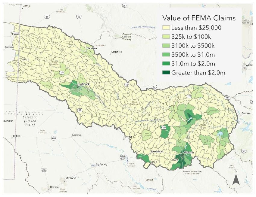
Recommending FMEs, FMSs, & FMPs

                                  Potential Reasons to Not Recommend:
                                  •   No flood risk reduction
       Recommend as many          •   No local sponsor
       evaluations, strategies,   •   Misalignment with goal(s) and/or guidance principles
       and projects as possible   •   Inappropriate scale
       that meet the technical    •   Duplicate projects
       requirements               •   Lack of concurrence from impacted entities
                                  •   Impractical benefit-cost ratio or other metric
                                  •   Public input
                                  •   Lack of RFPG consensus

                                                                 F R E E S E   A N D   N I C H O L S
Task 4A Needs Analysis
   Most prone to      Locations, extent,
                                           Prone to flooding
   flooding that      & performance of
                                           with inadequate
  threatens life &        policies &
                                           inundation maps
      property          infrastructure

                                           Existing models,
                                           analysis, & flood
  No H&H models       Emergency need
                                            risk mitigation
                                                 plans

                                               Already
 Already identified
                      Historic flooding      implemented
  flood mitigation
                           events          flood mitigation
      projects
                                               projects

                       Other relevant
                          factors

                                                               F R E E S E   A N D   N I C H O L S
Task 4A Needs Analysis

• "HUCs" are standard
  USGS watershed
  boundaries
• HUC 12 is the local
  sub-watershed level
  that captures tributary
  systems
• Each HUC 12 receives a
  score out of 5 or 3 for
  each criteria

                            F R E E S E   A N D   N I C H O L S
Task 4A Needs Analysis
• Buildings in the 100-year
floodplain
Most prone to flooding that threatens life & property
F R E E S E A N D N I C H O L STask 4A Needs Analysis
• Critical facilities in the
100-year floodplain
F R E E S E A N D N I C H O L SCity of Lubbock Critical Facility Impacts
Case Study:
Critical Facilities
• 9% of region-wide
critical facilities
potentially at risk
**100-year existing analysis conducted with draft data
F R E E S E A N D N I C H O L STask 4A Needs Analysis
• Agricultural and
energy areas in the
floodplain
F R E E S E A N D N I C H O L SHale County Agriculture Impacts
Case Study:
Agriculture
• Only 4% of region’s area
exposed to preliminary
flood hazard is urban
development
**100-year existing analysis conducted with draft data
F R E E S E A N D N I C H O L SHockley County Well Impacts
Case Study:
Energy
• 8% of active oil wells in
100-yr floodplain
• Using 2021 RRC
Production estimates,
one day lost production
in Hockley County:
~$162K.
**100-year existing analysis conducted with draft data
F R E E S E A N D N I C H O L STask 4A Needs Analysis
• Miles of road in the floodplain
F R E E S E A N D N I C H O L SCity of Abilene Roadway Impacts
Case Study:
Roadways
• 8% of region-wide
roadways potentially at
risk
**100-year existing analysis conducted with draft data
F R E E S E A N D N I C H O L STask 4A Needs Analysis
• Low water crossings in the
floodplain
F R E E S E A N D N I C H O L STask 4A Needs Analysis
• NFIP participation
F R E E S E A N D N I C H O L STask 4A Needs Analysis
• Areas lacking H&H models
F R E E S E A N D N I C H O L STask 4A Needs Analysis
• Number of flood prone areas
marked on comment map
F R E E S E A N D N I C H O L STask 4A Needs Analysis
• # of Presidential Disaster
Declarations (flooding)
F R E E S E A N D N I C H O L STask 4A Needs Analysis
• Value of reported FEMA
claims w/in 2.5 miles of
HUC12 boundary
F R E E S E A N D N I C H O L SFME – Flood Management Evaluation
• Study of a specific, flood-prone area needed to assess flood risk and/or determine
whether there are potentially feasible FMSs or FMPs.
FMP – Flood Management Project
• Project, either structural or non-structural, that has non-zero capital costs or other non-
recurring cost and will reduce flood risk, mitigate flood hazards to life or property.
FMS – Flood Management Strategy
• Plan to reduce flood risk or mitigate flood hazards to life or property. Actions the group
would like to identify, evaluate, and recommend that do not qualify as FME or FMP.
F R E E S E A N D N I C H O L SFME Identification
Project Sources
• Hazard Mitigation Action Plans
• County & City Drainage Master Plan to
identify specific projects from HMAP
actions
• Survey responses for flood prone areas
• Projects from Drainage Master Plans that
need further study
• Results of Flood Risk Evaluation (Task 2)
• Structures
• Low Water Crossings
• Results of Needs Analysis
• FEMA Mapping – Initial or Updated
• City Drainage Master Plan for Cities with
high priority HUC12s
F R E E S E A N D N I C H O L SFME Identification
Project Types
• Watershed Planning
• H&H Modeling
• Flood Mapping Updates
• Regional Watershed Studies
• Engineering Project Planning
• Feasibility Assessments
• Preliminary Engineering (alternative
analysis and up to 30% design)
• Studies on Flood Preparedness
F R E E S E A N D N I C H O L SFME – Flood Management Evaluation
• Study of a specific, flood-prone area needed to assess flood risk and/or determine
whether there are potentially feasible FMSs or FMPs.
FMP – Flood Management Project
• Project, either structural or non-structural, that has non-zero capital costs or other
non-recurring cost and will reduce flood risk, mitigate flood hazards to life or property.
FMS – Flood Management Strategy
• Plan to reduce flood risk or mitigate flood hazards to life or property. Actions the group
would like to identify, evaluate, and recommend that do not qualify as FME or FMP.
F R E E S E A N D N I C H O L SFMP Identification
Project Sources
• Hazard Mitigation Action Plans
• Projects from Drainage Master Plans
• City of Abilene
• City of Lubbock
• Results of Needs Analysis
Requirements
• Detailed H&H modeling results
• Quantified reduction of impact from
floods
• Associated benefits and costs
F R E E S E A N D N I C H O L SFMP Identification
Project Types – Structural
• Low Water Crossings or Bridges
• Infrastructure
• channels, ditches, ponds, stormwater
pipes, etc.
• Regional Detention
• Regional Channel Improvements
• Reservoirs
• Dam Improvements, Maintenance, and
Repair
• Flood Walls/Levees
• Nature Based Projects (Playas)
• Comprehensive Regional Projects
F R E E S E A N D N I C H O L SFMP Identification
Project Types – Non-Structural
• Property or Easement Acquisition
• Elevation of Individual Structures
• Flood Readiness and Resilience
• Flood Early Warning Systems, including
stream gauges and monitoring stations
• Floodproofing
• Regulatory Requirements for Reduction
of Flood Risk
F R E E S E A N D N I C H O L SFME – Flood Management Evaluation
• Study of a specific, flood-prone area needed to assess flood risk and/or determine
whether there are potentially feasible FMSs or FMPs.
FMP – Flood Management Project
• Project, either structural or non-structural, that has non-zero capital costs or other non-
recurring cost and will reduce flood risk, mitigate flood hazards to life or property.
FMS – Flood Management Strategy
• Plan to reduce flood risk or mitigate flood hazards to life or property. Actions the group
would like to identify, evaluate, and recommend that do not qualify as FME or FMP.
F R E E S E A N D N I C H O L SFMS Identification
Project Sources
• Hazard Mitigation Action Plans
• Survey responses
• Proposed plans to reduce flood risk or
mitigate flood hazards to life or property
• May or may not require associated FMPs
to be implemented
• Actions group would like to recommend
that don’t fall into FMEs or FMPs – Task 3
Goals
F R E E S E A N D N I C H O L SFMS Identification
Project Types
• Public Awareness about Flood Safety
• Assessments of Low Water Crossings in
several areas to evaluate design and
construction possibilities
• Dam Inventory and Assessment
• Agriculture Flood Losses Inventory and
Assessment
F R E E S E A N D N I C H O L SProject List as of
11/19/2021
Summary Table
123 FME 27 FMP 172 FMS
85 Watershed Planning 10 Infrastructure Projects 9 Education and Outreach
3 Project Planning 12 Storage Projects 105 Regulatory and Guidance
0 Flood Preparedness 4 Preparedness 43 Hazard Reduction Programs
32 Other 1 Acquisition/Elevation 8 Other
F R E E S E A N D N I C H O L S2
TA S K 4 : F M E , F M S , F M P
P R O C E S S – A P P R O VA L
F R E E S E A N D N I C H O L S3
TA S K 4 C : I N T E R I M
TECHNICAL MEMORANDUM
F R E E S E A N D N I C H O L STask 4C Interim Technical Memorandum
A. List of Existing Political Subdivisions With Flood-Related Authorities or Responsibilities
B. List of Previous Flood Studies to be Considered by the RFPG for Development of the RFP
C. Existing Flood Hazard Geodatabase and Associated Maps Deadline Extended to
D. Flood Mapping Gaps Geodatabase and Associated Maps March 7, 2022
E. Hydrologic And Hydraulic Models Needed Geodatabase and Associated Maps
F. List of Available Flood-Related Models to be Considered for Developing the RFPG
G. Flood Mitigation and Floodplain Management Goals Adopted by the RFPG
H. Documented Process Used by the RFPG To Identify Potentially Feasible FMSs And FMPs.
I. List of Potential FMEs and Potentially Feasible FMSs And FMPs
J. List of FMSs and FMPs Identified but Determined to be Infeasible
K. Spatial Data Inventory – GIS Deliverables
F R E E S E A N D N I C H O L SSpatial Data Inventory – GIS Deliverables – Dashboard
File # Item Name Feature Class Name Submittal Date
1 Entities Entities January 7, 2022
2 Watersheds Watersheds January 7, 2022
3 ExFldInfraPol
4 Existing Infrastructure ExFldInfraLn January 7, 2022
5 ExFldInfraPt
6 Proposed or Ongoing Flood Mitigation Projects ExFldProjs January 7, 2022
7 Existing Flood Hazard ExFldHazard March 7, 2022
8 Flood Mapping Gaps Fld_Map_Gaps March 7, 2022
9 ExFldExpPol
10 ExFldExpLn
11
Existing Exposure ExFldExpPt
March 7, 2022
12 ExFldExpAll
13 Future Flood Hazard FutFldHazard March 7, 2022
14 FutFldExpPol
15 FutFldExpLn
16
Future Exposure FutFldExpPt
March 7, 2022
17 FutFldExpAll
18 Existing Floodplain Management Practices ExFpMP January 7, 2022
19 Goals Goals January 7, 2022
20 Streams Streams January 7, 2022
21 Flood Management Evaluations FME January 7, 2022 – Limited Fields
22 Flood Mitigation Projects FMP January 7, 2022 – Limited Fields
23 Post Project Hazard FMP_HazPost August 1, 2022 – Draft Plan
24 Project Details FMP_Details August 1, 2022 – Draft Plan
25 Flood Management Strategies FMS January 7, 2022 – Limited Fields
F R E E S E A N D N I C H O L S3
TA S K 4 C : I N T E R I M
TECHNICAL MEMORANDUM
- O P T I O N F O R A P P R O VA L
When reviewing and considering whether to approve drafts of the ITM, the RFPG
members should do so with the understanding that the TWDB has established the
purpose of the ITM “to be a draft, mid-point, work-in-progress deliverable…to
demonstrate that [the RFPG] are making appropriate progress towards the development
of their regional flood plan and in meeting contract requirements.”
F R E E S E A N D N I C H O L S4
TA S K 2 : F L O O D R I S K
U P D AT E
F R E E S E A N D N I C H O L SFathom Data
• Available October 29, 2021
• Depth filtered out < 6 inches
o Fluvial
▪ Statistical analysis
▪ Sub-grid hydrodynamic modeling
o Pluvial
o Atlas 14 rainfall
o Rain on grid methodology
F R E E S E A N D N I C H O L S100-Year
Fathom
• Replacing FAFDS
• Areas of limited or no flood
risk information
F R E E S E A N D N I C H O L SSummary of Existing Conditions
• 100-Year • 500-Year
• Maintain Flood Risk Mapping • Maintain Local Studies, NFHL
o Local Studies Detailed Studies, Base Level
o NFHL Detailed, Approximate Engineering
and Preliminary Studies • Fathom to supplement existing
o Base Level Engineering approximate studies for 500-
• Utilize Fathom year
o Replace FAFDS
o Gaps/Lack of Flood Risk
Data
F R E E S E A N D N I C H O L SFuture Conditions
• “No Action” Scenario for ~30 years o Anticipated Climate Change
o Continued Population Growth o Anticipated Land Changes
o Continued Development o Completion of Flood Mitigation
Increase Projects by 2050
o Current Floodplain
Management
Regulations/Policy
F R E E S E A N D N I C H O L SFuture Conditions
• Assumptions and Estimation Options (per TWDB Guidance)
o Increase based on population/development growth
▪ Freeboard: Water surface elevation increase
▪ Floodplain Buffer: Floodplain width increase
o Utilize existing conditions 0.2% annual chance event (500-yr) floodplain
o Combination of above assumptions
F R E E S E A N D N I C H O L SFuture Conditions Approach
• On the Caprock vs. Off the Caprock
• Significantly varied topography
• Conveyance and storage
• Playas vs. Riverine
• Anticipated Population Growth
• Recommendation:
• Two Separate Approaches to Future
Conditions
F R E E S E A N D N I C H O L SFuture Conditions Approach
On the Caprock
• Lubbock – Hold FFD Studies for 100-year and 500-year
• Plainview – Use Fathom to supplement existing 100-year studies; Fathom 500-year for Future 100-year
• Recommend holding 100-year and 500-year existing conditions for future conditions
• Lack of projected population growth
• Climate change impacts considered negligible in areas of limited projected growth (Nielson-Gammon)
• Atlas 14 rainfall changes considered minimal
• Sedimentation of playas
• Studies having considered 20+ years of data state “negligible effects”
• Playa maintenance occurring in urbanized areas recommended to continue to provide storage capacity
• Evaluation of impacts needed to assess impacts to water table, infiltration rates, etc. due to disturbing
compacted playa soils
F R E E S E A N D N I C H O L SFuture Conditions Approach
Off the Caprock
• Areas of Existing Studies
• Fisher, Nolan, Taylor, Jones, Shackleford, Young
• Supplement with Fathom where gaps in existing conditions detailed studies and Zone A
approximate studies
• Existing 500-year to become future 100-year
• Future 500-year area of potential flood risk
• Buffer by % difference in area between existing 100-year to 500-year
• Buffer Future 100-year flood extents to establish 500-year area of potential flood risk
F R E E S E A N D N I C H O L SFuture Conditions
• Playas • Riverine
• Review of Lubbock Playa Models • BLE Studies
• 2009 MDP Data • FIS Studies
• Current MDP Studies
• FIS Studies
Upper Brazos Average WSEL Change Average WSEL Change Average WSEL Change Average 100yr WSEL Change
Data Source
Regions Existing Vs Future 100yr (ft) Existing 100yr vs 500yr (ft) Future 100yr vs 500yr (ft) with 12% Increase
Riverine (Detailed) -1 1.4 -1 -1
On-Caprock Overflow 0.5 0.4 0.3 2 0.1 2
Playas
Non-Overflow 0.6 1.1 0.9 2 0.4 2
Riverine (Detailed) -1 1.3 -1 -1
Off-Caprock
Riverine (BLE) -1 0.9 -1 -1
1 Region lacking riverine future comparisons. Refer to other regional studies for consideration. Recommend using 500yr for Future 100yr approximation.
2 Differences are based on MDP FFD studies.
F R E E S E A N D N I C H O L SYou can also read