Research-driven Tools for Ocean Mappers - Hydro International
←
→
Page content transcription
If your browser does not render page correctly, please read the page content below
The global magazine for hydrography
                                                                    www.hydro-international.com

                                                                       January/February 2018 | Volume 22 number 1

           Research-driven
           Tools for Ocean
           Mappers
                                                Your Guide to Oceanology
                                                International 2018!
           Finding Lost Aircraft with Pingers   World’s First Fully Autonomous Hydrographic Survey

01_cover.indd 1                                                                                            21-02-18 15:19
When the pressure is on,
depend on us to keep you connected.

                      We provide the broadest
                       range of high performance
                       electrical, optical, and hybrid
                       interconnect capabilities,
                       optimized for use in mission-
                       critical applications.

                       www.teledynemarine.com
CONTENTS
P. 14 World’s First Fully Autonomous Hydrographic Survey
During September 2017, the world’s first autonomous hydrographic
survey was performed. ‘Autonomous’ means not by remote control,
but rather that the autonomous surface vehicle (ASV) used guidance
from survey software to run pre-planned survey lines or automatically
Hydro International is an independent international magazine published 6 times a year generated lines based on sonar coverage, with human interaction
by Geomares Publishing. The magazine and related e-newsletter inform worldwide possible but not required.
professional, industrial and governmental readers of the latest news and developments
in the hydrographic, surveying, marine cartographic and geomatics world. Hydro
International encompasses all aspects, activities and equipment related to the
acquisition, processing, presentation, control and management of hydrographic and P. 18 Finding Lost Aircraft with Pingers
surveying-related activities. Although the number of aircraft lost at sea is not very high, in the
past years a number of aircraft have literally been lost at sea. With the
recently renewed search for Malaysian Airlines flight 370 (MH370), one
wonders about the technology in the underwater location of aircraft,
and other high value objects. Underwater Locator Beacons (’ULBs’ or
Geomares Publishing ‘pingers’) are used for this, either on the airframe itself or on the black
P.O. Box 112, 8530 AC Lemmer, The Netherlands
Phone: +31 (0) 514 56 18 54, Fax: +31 (0) 514 56 38 98 box.
info@geomares.nl
www.geomares.nl
P. 22 Seabed 2030: A Call to Action
No material may be reproduced in whole or in part without written permission from Many people like me start speeches about mapping the ocean with “we
Geomares Publishing know more about the surface of Mars than we do about the bottom of
Copyright © 2018, Geomares Publishing, The Netherlands
All rights reserved. ISSN 1385-4569 our ocean.” And despite years of speeches and countless days at sea
surveying, we still have mapped less than 20 percent of the world’s
Publishing Director: Durk Haarsma
Financial Director: Meine van der Bijl oceans. Even in the relatively wealthy United States, only thirty percent
Editorial Board: RADM Giuseppe Angrisano (retd) of the Italian Navy, Martien of our waters are mapped. It is time to get organised.
Coolegem, MSc, Huibert-Jan Lekkerkerk, Duncan Mallace, Mark Pronk, BSc, Marck Smit,
NOAA Corps (retd.), Auke van der Werf
Contributing Editors: Andrew Armstrong (USA), Gary Chisholm
(New Zealand), Safaruddin Kamaruddin (Malaysia), Cdr Ayodeji Olugbode (Nigeria), P. 24 Shallow Inland Water Bathymetry
Andrew Leyzack (Canada) For many years, the GeoSwath system from Kongsberg GeoAcoustics
Content Manager: Wim van Wegen
Copy Editor: Kirsten van Hasselt has been providing an efficient simultaneous swath bathymetry and
Key Account Manager: Sybout Wijma
Account Manager: Sharon Robson, Thomas Stuiver side-scan seabed mapping solution with accuracies that meet the IHO
Circulation Manager: Adrian Holland
Design: ZeeDesign, Witmarsum, www.zeedesign.nl S-44 Special Order standard for hydrographic surveys.
Advertisements P. 35 Israeli Navy Transforms to New GIS Technology
Information about advertising and deadlines are available in the Media Planner. For
more information please contact our key account manager The Israeli Navy Hydrographic Branch (INHB) is transforming itself
(sybout.wijma@geomares.nl) or go to www.geomares.nl/advertising. into a 21st century organisation. Moving away from traditional methods
of generating hydrographic products, INHB have adopted geographic
Paid Subscription
Hydro International is available bi-monthly on a subscription basis. The annual information system (GIS) technology. This forms part of the evolution
subscription rate for Hydro International is €36. You can subscribe at any time via
https://geomares-education.com/shop/subscriptions/hydro-international. towards a full modern Marine Spatial Data Infrastructure (MSDI).
Subscriptions will be automatically renewed upon expiry, unless Geomares Publishing
receives written notification of cancellation at least 60 days before expiry date. Prices
and conditions may be subject to change. Multi-year subscriptions are available P. 44 Oceanology International 2018 Preview
visiting https://geomares-education.com/shop/subscriptions/hydro-international
Hydro International highlights the key exhibitors with their own company
Editorial Contributions profiles. Check out our Oi18 preview to find out what these leading
All material submitted to the publisher (Geomares Publishing) and relating to Hydro companies have to offer, and why you should definitely stop by their
International will be treated as unconditionally assigned for publication under
copyright subject to the Editor’s unrestricted right to edit and offer editorial comment. booths.
Geomares Publishing assumes no responsibility for unsolicited material or for the
accuracy of information thus received. In addtion, Geomares Publishing assumes no
obligation for return postage of material if not explicitly requested. Contributions must
be sent to the content manager wim.van.wegen@geomares.nl.
P. 05 Editorial Notes P. 38 Offshore Survey Business in Turkey
P. 06 Insider’s View P. 41 Towards a New Sonar Imaging Concept
Reprints P. 13 Technology in Focus for Survey
Back issues can be ordered from https://geomares-education.com/shop/magazines/ P. 29 Research-driven Tools for Ocean Mappers
hydro-international
SURVEYING THE ARCTIC
In 2016, a group of MBARI (Monterey Bay Aquarium Research Institute) The global magazine for hydrography
www.hydro-international.com
scientists and engineers, led by geologist Charlie Paull, returned to the
January/February 2018 | Volume 22 number 1
Beaufort Sea on the Canadian Coast Guard Icebreaker Sir Wilfrid Laurier in
collaboration with researchers from the Geological Survey of Canada and
Fisheries and Oceans Canada. Paull and his team conducted mapping
surveys with an autonomous underwater vehicle (AUV), followed by dives with
a remotely operated vehicle (ROV) to ground-truth the mapping surveys and Research-driven
Tools for Ocean
conduct targeted sampling. This photo was taken during this Canadian Arctic Mappers
Your Guide to Oceanology
International 2018!
2016 Expedition. (Photo: Monterey Bay Aquarium Research Institute.)
Finding Lost Aircraft with Pingers World’s First Fully Autonomous Hydrographic Survey
01_cover.indd 1 21-02-18 15:19
Hydro I N T E R N AT I ON A L | JA N U A RY / F EB R U A RY 2 0 1 8 | 3
03_content.indd 3 21-02-18 16:16
13–15 MARCH 2018, LONDON, EXCEL
                                  at H100
Editorial Notes

        Trend break                                                          The full package
        Every two years the oceanographic and hydrographic world eyes        The first Hydro International issue of 2018 focusses on Oceanology
        London, where Oceanology International takes place. This year        International, which is why we decided to include a varied series of articles
        the biennial show and conference will take place from March 11       in this edition. I can safely say that this issue pretty much reflects what the
                                                                             hydrographic and marine surveying industry encompasses, as will the next
        through 13 at ExCeL, London. With around 500 exhibitors, this        editions. From the search of lost aircrafts on the bottom of the ocean and
        tradeshow is by far the biggest in the industry and visitor          the exciting developments concerning fully autonomous hydrographic
        numbers are showing the same: Oceanology International is the        surveying, and shallow-water bathymetry to the massive efforts that will
                                                                             need to be made before we can map the bottom of all the oceans on our
        place to be. There will be a lot to talk about with each other       planet. We will take you on a pleasant journey in which we will educate,
        during OI: the future of the oceans in general and more              inform and inspire you on the adventurous profession that we are all
        specifically topics like fossil vs. renewable energy and             involved in. And don’t forget to visit our website (www.hydro-international)
                                                                             regularly, as this is the quickest way to stay up-to-date with the latest trends
        aquaculture. We haven’t been experiencing the best years for         and developments in the world called hydrography.
        hydrography. I am curious to see if this OI can show a trend
        break in optimism with entrepreneurs and corporate managers          Wim van Wegen, content manager
                                                                             wim.van.wegen@geomares.nl
        alike in their outlook for the business, where low oil prices are
        still keeping forecasts bleak. It is definitely good to exchange
        views and opinions, chances and threats and to see
        demonstrations of innovative products at a friendly competitor’s
        booth. In this issue of Hydro International you’ll find everything
        and more about Oceanology and what will be showcased in
        ExCeL by the large and small companies of our business. The
        Geomares team will also be producing a show daily for all OI
        event days: so make sure to grab one of these when in London
        to be in the know of the latest news. Of course we’ll also be
        present at our booth L20: stop by for a coffee and chat about
        business, opportunities, challenges and trends – and possibly
        how to break them in a positive way!

        Durk Haarsma,
        director strategy & business development
        durk.haarsma@geomares.nl

                                                                                       hydro Alphabetical list of advertisers
                                                                             Advanced Navigation 20                   QPS4
                                                                             ASV Global          51                   SBG Systems          34
                                                                             Blueprint Subsea     7                   Seafloor Systems     28
                                                                             CHC Navigation      28                   Teledyne Caris       30
                                                                             Evologics52                              Teledyne Group        2
                                                                             Innomar46                                Valeport34
                                                                             iXblue8                                  Wärtsilä ELAC Nautic 12

                                                                                             Hydro i n t e r n at i on a l   | ja n u a ry / f eb r u a ry 2 0 1 8 | 5

05_editorial.indd 5                                                                                                                                                21-02-18 16:21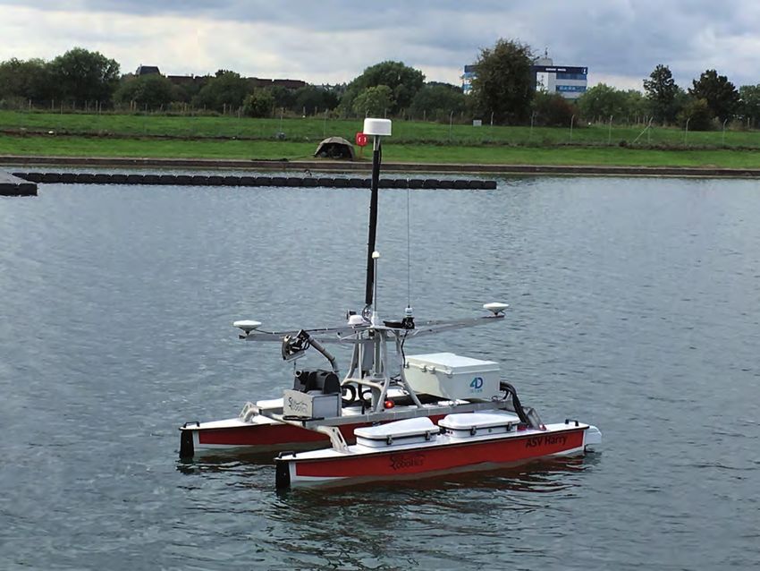
Insider’s View |         Michael Bergmann, BM Bergmann-Marine, Germany

                                                    From Products to Data
                                                    Services
                                                    When looking at the classic work of Hydrographic Offices the most prominent outputs had been
                                                    navigational charts – either printed or as ENCs – and other products for navigators, like publications. But
                                                    while these are still the main deliverables of HOs, times are changing. S-102, the first so-called ‘Product
          EAB
          The Editorial Advisory Board (EAB) of     Specification’ within the S-100 series of standards, is intentionally not defining a product navigators or
          Hydro INTERNATIONAL consists of
          professionals, from various fields,
          who independently make                    other end-users can buy and consume. It is a data stream for various uses.
          recommendations on potential authors
          and specific topics. The EAB members
          also contribute to this column. The
          EAB is served on a non-committal
          basis.

          Rear admiral Chris Andreasen              Today’s world is highly connected. Buzz words like IoT and Big
          (retd)
          NGA Maritime Safety Office (USA)          Data Analysis are indications that data is nowadays used in a
                                                    wider sense than originally envisioned:
          Michael Bergmann
          Owner, BM Bergmann-Marine                 Through integration with other data streams, the value of
          (Germany)
                                                    hydrographic data is enriched and reaches user communities
          Rear Admiral Shepard Smith                which haven’t been focussed on before.
          Director, Office of Coast Survey,
          National Oceanic and Atmospheric          This edition of Hydro International is on Oceanology. It
          Administration (USA)
                                                    underlines the trend described above. Oceanology looks at the
          Rear admiral Dr Neil Guy
          (retd)                                    conditions of the oceans and helps us understand this source of
          Maritime affairs and hydrographic         life on Earth better. Hydrography is an essential aspect. Utilising
          consultant (South Africa)
                                                    oceanographic and hydrographic data together makes analytical
          Dr John K. Hall (retd)
          Geological Survey of Israel (Israel)      tools possible to provide information that enables new views on
          Dr Mathias Jonas                          topics of importance for Oceanology. It is enabling new strategies
          Secretary-General International           for human communities in the future. But in doing so, the
          Hydrographic Organization (Monaco)
                                                    hydrographers need to enable access to their data stream
          Capt Abri Kampfer
          Director, International Hydrographic      without restricting it to a specific use like navigation. Bathymetric     Michael Bergmann.
          Organization (Monaco)
                                                    data in S-102 is geared up for this and shows that, in its working
          Nick Lambert                              groups, the IHO has already recognised the transformation from
          Director, Nick Lambert Associates Ltd
          (UK)                                      end-user product creation to usage-independent data streams
          Prof. Dr Mohd Razali Mahmud               years earlier.
          Director of the Centre for
          Hydrographic Studies, Faculty of          Now it is up to the individual Hydrographic Offices to migrate
          Geoinformation Science and                their organisations in this direction to bring this forward-looking     the new data streams can be utilised. This will require a shift in
          Engineering of the Universiti Teknologi
          Malaysia (Malaysia)                       development of IHO to life. And, the industry is already seeing         how HOs license their data for commercial use. Again, some
          Edward J. Saade                           this development. Some HOs are starting to provide the data in          HOs have already moved in this direction, but full usage will
          President/managing director, Fugro
          Earth Data, Inc. (USA)                    this format for various uses. As we see more and more HOs               require larger coverage of available, licensed data – ultimately
                                                    moving in this direction we can increase applications, both in          worldwide. Only then will the community, locally, regionally and
          Luis Salgado
          President, Desmar Ltd (Chile)             academic research as well as in industry used applications              globally, be able to really benefit to the largest extent.
          Mark Sinclair                             integrating hydrographic data in far reaching ’Big Data Analysis’       Thus, in essence the request to the hydrographic community is
          Service Line director Hydrographic
          Services Asia-Pacific and                 tools.                                                                  1. Develop and provide data streams in usage independent
          managing director Fugro LADS
          Corporation (Australia)                   But all of that only works if the HOs develop usage agreements          form, such as, but not limited to, S-102
                                                    supporting this concept. The underlying legal framework with            2. Create data usage agreements to enable and support this.
          David Whitcombe
          Chief surveyor for Europe, Shell (UK)     usable and economically viable conditions is essential so that          Research and industry are ready….

           6 | J a n u a ry /F e br ua ry 2 0 1 8 | Hydro int e r nat io na l

06_insider39;sview.indd 6                                                                                                                                                                 21-02-18 16:25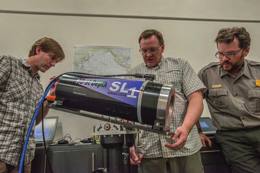
NEWS

       Oi18 Expands to Offer Even More
       Vessel and Dockside Demos for                                                                                           www.blueprintsubsea.com
       Visitors                                                                                                                    sound by design

                                                      Visitors to Oceanology International 2018 (Oi18)
                                                      will be able to participate in a series of live product
                                                      demonstrations from the event’s waterside exhibitor
                                                                                                                              Multibeam Imaging Sonars
                                                      area on the Royal Victoria Dock. Oi18 will be held at                   Single and Dual Frequency Operation
                                                      ExCel, London, UK, from 13-15 March. The programme
                                                      will offer a great variety of interactive experiences
                                                      from some of the industry’s leading ocean technology
                                                      manufacturers. As one of the most popular attractions
          Dockside exhibition area.                   for Oceanology International visitors, this year’s dockside
                                                      and on-water demo programme has been expanded and
       will now comprise daily demonstrations to offer an even more valuable experience for those attending,
       whilst allowing exhibitors to share their product effectiveness in a marine environment.
        http://bit.ly/2F3Jrxc

          The Ocean Cleanup Contracts
          Seatools as Offshore Monitoring                                                                                     Micro-USBL Tracking Beacons
          System Supplier                                                                                                     Bidirectional Acoustic Data Modems

          The Ocean Cleanup, the Dutch non-profit organisation developing advanced technologies to rid
          the world’s oceans from floating plastic, has awarded subsea technology company Seatools a
          contract for the development and delivery of a remote offshore monitoring system. The
          monitoring system will be used to gain real-time insight into the performance of the first-ever
          ocean cleanup system, which will be deployed during trials starting later this year on the west
          coast of the USA.
            http://bit.ly/2F5Rjyp

                                                                                                                              Portable Sidescan Sonars
                                                                                                                              Towed, OEM, Hull and Pole Mounted

                                                                                                                                   Oi
                                                                                                                                    OCEANOLOGY INTERNATIONAL
                                                                                                                                   13-15 MARCH 2018, LONDON, EXCEL
             The Ocean cleanup system.                                                                                              Visit us on stand F650

                                                                                                                    Hydro i n t e r n at i on a l   | Ja n u a ry / F eb r u a ry 2 0 1 8 | 7

                                                                                                                                BlueprintSubsea HydroInternational ThirdPage-Vert Advert 2018-02 (CMYK, 300dpi)

07-09-10-11-12_news.indd 7                                                                                                      23 January 2018 16:18:39                                  21-02-18 13:42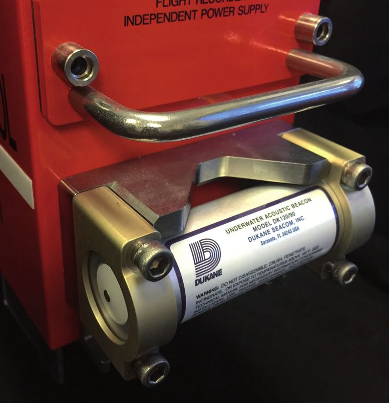
SAMS: the new
generation of
side-scan sonar.

SAMS Series Synthetic Aperture Mapping Sonar
+ Delph Series Software

• High-resolution images on all kinds of carriers
• Real time mapping
• Increased productivity
More news www.hydro-international.com

       First High-resolution                                                UKHO to Conduct Seabed Mapping
       Map of the Great                                                     around British Virgin Islands
       Barrier Reef Released                                                The United
                                                           One and a        Kingdom
                                                           half million     Hydrographic Office
                                                           square           (UKHO) has
                                                           kilometres       chartered two boats
                                                           of               to survey the waters
                                                           bathymetric      around the British
                                                           seafloor         Virgin Islands as
          High-resolution map of the Great Barrier Reef.   data have        part of the UK’s
                                                           been             Overseas Territories
       released to the public by Geoscience Australia under                 Seabed Mapping
       partnership with James Cook University and the Australian            Programme
       Hydrographic Service of the Great Barrier Reef. The project          (OTSMP)
       carried out high-resolution bathymetric scans, which were            commitments.
       combined with existing datasets held by the government to            Following the             Planned survey priority areas.
       create the most comprehensive, detailed models produced to           interruption of the
       date.                                                                original UKHO surveys by Hurricanes Irma and Maria in September 2017, the survey team
         http://bit.ly/2EtKdCy                                              is returning to complete the originally planned activities. In addition, to aid the disaster
                                                                            recovery, several urgent priority areas have been identified locally and added to this survey.
                                                                            Using state of the art multibeam sonar equipment to map key areas of the seabed, the

          N-Sea Awarded £40                                                 survey will enable the production of accurate and up-to-date navigational charts for ships
                                                                            using waters in Road Bay and North Sound. These charts will improve access for trade and

          Million of International                                          tourism-related industries, and enable a wider range of ships to safely call at the islands.
                                                                              http://bit.ly/2EvI2Th

          Contracts
                                                                          Satellites Provide Detailed Picture
          UK and Netherlands-based subsea provider N-Sea has
          announced that it secured major contracts to the value of

                                                                          of Maritime Activity
          £40 million, during Q4 of 2017 and in early Q1 2018,
          providing a sound backlog for the coming season. Known
          for its innovative work as an independent offshore subsea
          contractor, N-Sea’s expertise in the fields of unexploded       ESA has helped coastal authorities to track up to 70% more ships and pick up nearly three times
          ordnance (UXO) survey, ROV and tooling solutions, diving        more ship positions via satellite than was possible before. Large cargo vessels and passenger
          and subsea maintenance and construction will be                 ships are required to carry Automatic Identification System equipment which transmits the course
          employed. These projects – which include UK east coast          and speed as well as identification and position information to other vessels and shore stations.
          wind farm work, interconnector cable projects and               Originally developed to prevent collisions, it now also tracks ships to help prevent pollution, aid
          German Baltic scopes – will be delivered with a variety of      in the movement of dangerous goods, and promote routine surveillance. The Norwegian Coastal
          vessels on behalf of customers in the oil and gas,              Administration is using the information to manage the national coast and waters for safety,
          renewables and utilities sectors.                               emergency and transport planning.
            http://bit.ly/2HisgZu                                           http://bit.ly/2sxIbQo

                                                                                                                                                                           The colour
                                                                                                                                                                         code shows
                                                                                                                                                                         how many
                                                                                                                                                                         times each
                                                                                                                                                                         ship has
             The Siem, a multi-purpose field and ROV support vessel.                                                                                                     been
                                                                                                                                                                         observed.

                                                                                                             Hydro i n t e r n at i on a l   | Ja n u a ry / F eb r u a ry 2 0 1 8 | 9

07-09-10-11-12_news.indd 9                                                                                                                                                         21-02-18 13:43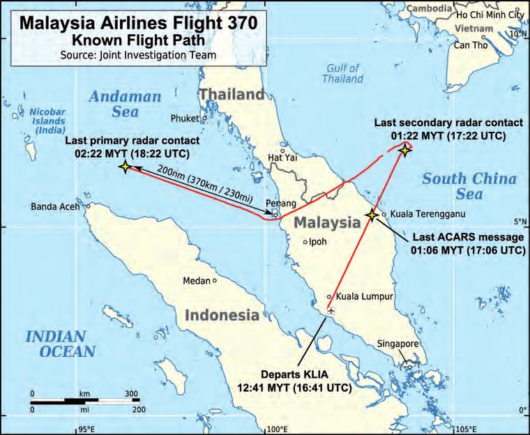
NEWS

       Subsea 7 Utilises                                                         Survey Expedition to Laser Scan
       Autonomous Surface                                                        the Titanic Wreckage
       Vessel in Mediterranean                                                   OceanGate, a provider of

       Pipelay Operation                                                         manned submersible
                                                                                 services, and 2G Robotics,
                                                                                 a global leader in
       ASV Global has announced the successful deployment of                     underwater laser
       one of its C-Worker 7 class of autonomous surface vessels for             scanners, have formed a
       Subsea 7. The 7m autonomous surface vessel was used to                    strategic alliance to
       support a pipelay operation off the coast of Egypt. Fitted with a         capture laser data of the
       survey suite comprising a multibeam echo sounder and side-                RMS Titanic shipwreck
       scan sonar, the C-Worker 7 carried out touchdown monitoring               and debris field. 2G
       in support of the Seven Antares pipelay vessel.                           Robotics’ dynamic
         http://bit.ly/2EsrB67                                                   underwater laser scanner,
                                                                                 the ULS-500 PRO, will be         View of the bow of the Titanic.
                                                                                 installed on OceanGate’s
                                                                                 Cyclops 2, the first manned submersible to survey the Titanic since 2005. The six-week
                                                                                 Titanic Survey Expedition will depart from St. John’s, Newfoundland, Canada, in June with
                                                                                 scientists, content experts and mission specialists joining the crew in a series of week-long
                                                                                 missions. The innovative 2G Robotics equipment will generate real-time 3D models with
                                                                                 millimetric resolution. Using the highly accurate laser data, the team will overlay 4K images
                                                                                 captured throughout the expedition to create a detailed 3D virtual model of the wreck. This
                                                                                 model will serve as an objective baseline to assess the decay of the wreck over time and
                                                                                 help to document and preserve its submerged history.
                                                                                   http://bit.ly/2Hef6ga

                                                                               New Software Tool Automates
          The autonomous C-Worker 7.

                                                                               Subsea Data-processing Workflow
          Teledyne TSS
          Expands Subsea                                                       Danish software engineering specialist EIVA has released a new tool, NaviSuite Workflow
                                                                               Manager, for automatic data-processing of large amounts of subsea data, with minimum human

          Product Range                                                        involvement. With the Workflow Manager, repetitive tasks are automated and executed in parallel
                                                                               by the software. This means that data is processed faster, and crew members’ time is spent more
                                                                               efficiently on errors, interpretations and quality control.
                                                    Teledyne TSS, a              http://bit.ly/2EEGshb
                                                    division of
                                                    Teledyne Marine,
                                                    is increasing its
                                                    range of subsea
                                                    pipe and cable
                                                    detection and
                                                    tracking products
             HydroPACT 660 pipe tracking system. with the launch
                                                    of the new
          smaller HydroPACT 660 pipe tracking system. The 660
          has been designed to help reduce the cost of subsea pipe
          surveys by allowing the use of smaller classes of
          underwater remotely operated vehicles (ROVs). In
          addition, TSS is also expanding the capabilities of its
          larger HydroPACT 440 pipe tracking system by
          introducing a new 24VDC upgrade kit.
            http://bit.ly/2obDqXx
                                                                                 EIVA Navisuite Workflow Manager.

         10 | J a n u a ry /F e br ua ry 2 0 1 8 | Hydro int e r nat io na l

07-09-10-11-12_news.indd 10                                                                                                                                                  21-02-18 13:43
More news www.hydro-international.com
Ocean Infinity to Continue Olex Integrates Spatial
Search for Missing Malaysian Inertial Navigation System
Airlines Flight MH370 into Marine Vessels
The proposal by Ocean Infinity, a specialist in collecting high-resolution Nexans Olex
geophysical seabed data, to continue the search for the missing Malaysian has successfully
Airlines flight MH370 has been accepted by the Government of Malaysia. The integrated
search will focus initially on the zone identified by the Australian Transport Safety Spatial, an
Bureau. The Seabed Constructor vessel is now close to the search area, which inertial
will enable work to commence imminently. The project is expected to last for 90 navigation
days. Ocean Infinity will take on the economic risk of the renewed search, only system, into its
receiving payment if the aircraft wreckage is located. hydrographic
http://bit.ly/2o5SbL6 vessel. Spatial is
a ruggedised
miniature
GPS-aided
Spatial sensor integrated survey allows finer details. inertial
navigation
system and AHRS that provides accurate position, velocity, acceleration
and orientation. It combines temperature-calibrated accelerometers,
gyroscopes, magnetometers and a pressure sensor with an advanced
GNSS receiver.
http://bit.ly/2F32Lus
The Seabed Constructor.
United Nations Declares
Decade of Ocean Science
The United Nations has
announced the ‘Decade Your Partner
of Ocean Science for
Sustainable Development’ in Seabed
Sampling
(2021-2030) to mobilise
the scientific community,
policymakers, business
and civil society around a
programme of joint research
and technological innovation.
The announcement of
• box corers
this decade consolidates
efforts by UNESCO’s • piston corers
Intergovernmental • gravity corers
Oceanographic Commission developed by NIOZ
(IOC) to boost international
cooperation in ocean
Global Ocean Science Report. sciences. It will enable better
coordination of research
programmes, observation systems, capacity development, maritime space
planning and the reduction of maritime risks to improve the management of
ocean and coastal zone resources.
http://bit.ly/2Est10r
Den Helder | The Netherlands
Phone +31 223 613033 | info@cwpsmit.nl | www.cwpsmit.nl
Hydro i n t e r n at i on a l | Ja n u a ry / F eb r u a ry 2 0 1 8 | 11
07-09-10-11-12_news.indd 11 21-02-18 13:43NEWS
OceanAlpha Delivers Delivering a Subsea Lidar
Innovative USV Solution to Virtual Reality Data
Mining Industry Platform
OceanAlpha’s autonomous 3D at Depth, a global provider of advanced subsea Lidar systems and
bathymetric survey boat, the solutions, has partnered with iQ3Connect to deliver a new data visualisation
ME40 for hydrographic survey, tool to help clients build, maintain, map and monitor subsea assets,
has been applied in the mining environments and resources. The partnership leverages the innovative
industry for tailing dam surveys, in features of 3D at Depth’s subsea Lidar data and the power of iQ3’s
addition to its common application augmented reality (AR) and virtual reality (VR) platform to transform the
in lakes, rivers, reservoirs and value of offshore survey data.
Hydrographic survey software interface. oceans. All that is necessary is http://bit.ly/2EvjaqF
to set up the survey waypoints;
the boat can then acquire online bathymetric data automatically based on GPS
navigation.
http://bit.ly/2Him1os
Surveying the Wrecks of
the Battle of the Atlantic
After years of research, the
US National Oceanic and
Atmospheric Administration
(NOAA) discovered two
World War II shipwrecks off
the coast of North Carolina
in the Monitor National
Marine Sanctuary in 2014.
3D model of the German submarine U-576 The wrecks form the
(Courtesy: 2G Robotics). remains of the KS-520
convoy attack, as part of the
Battle of the Atlantic. It was through EIVA NaviSuite software that 2G
Robotics modelled these wrecks, once they had been surveyed from a
Triton submersible equipped with a Sonardyne acoustically aided inertial
navigation system (AAINS) and scanned by 2G Robotics’ laser scanner.
http://bit.ly/2Gfxh3Z 3D at Depth subsea Lidar system.
patented
Covering it all with sWept Beamtm
technology
from 600 metres up to
11,000 metres depth
performance
more than 50 years multI-pIng real-tIme
Water column
of multibeam fm mode
ImagIng (WcI)
know-how moBIle array
solutIons
advanced
transmIssIon
modular desIgn
for dIfferent
Ice resIstant desIgn
for the complete
Beam steerIng Beam WIdths survey range
WÄRTSILÄ CONNECTS THE DOTS
Wärtsilä ELAC Nautik develops and manufactures state-of-the-art multibeam systems for precise charting
of water bottom topography. No matter what the challenges are – Wärtsilä ELAC Nautik delivers.
Read more at www.wartsila.com/elac meet us at oceanology InternatIonal 2018 | stand f500
12 | J a n u a ry /F e br ua ry 2 0 1 8 | Hydro int e r nat io na l
07-09-10-11-12_news.indd 12 21-02-18 13:43Technology in Focus
Zooming in on hydrographic technology
The Technology in Focus articles are frequently featured on the website of Hydro International. Aim of this
series is to provide marine and hydrographic professionals with in-depth knowledge on a particular
technology. This page introduces three of them. You can read the full articles by visiting the website shown.
GNSS Receivers Acoustic Doppler
GNSS has now been operational in the Current Profilers
(ADCP)
surveying industry, and especially in
hydrography, for more than 25 years. Whereas
the first receivers such as the Sercel NR103
(once the workhorse of the industry) boasted
10 parallel GPS L1 channels, current receiver
technology has evolved to multi-GNSS, multi-
channel and multi-frequency solutions. In this
article, we look at the current state of affairs and
try to identify the areas where development can
be expected in the years to come.
In hydrography, we can distinguish between ‘land use’ and ‘marine use’ of our GNSS receivers.
Especially in the dredging, nearshore and inshore domains both land survey as well as maritime
receivers are employed. They do not differ in their basic capabilities such as positioning accuracy Rather than a spinning propeller, the Acoustic Doppler
of number of channels (and GNSS) they can receive. The main differences lie in the form factor Current Profiler (ADCP) - like dolphins and bats - uses
of the receiver (portable for land survey, rack mounted for marine survey) and the method of sound to explore its environment. Operating underwater,
operation. Whereas a land survey receiver is almost always combined with a separate controller the method works like hand-held radars used by police to
running extensive data acquisition software, the marine receiver is more and more of the black catch speeding motorists. This article explains the
box type with at most a minimal display (and sometimes none). technique of this frequently used type of instrument and
http://bit.ly/2GxfAwH some of its applications.
A sound burst is emitted by the ADCP along beams
Hydrographic Processing Software angled downward. Echoes are returned due to scattering
off particles carried by water currents. A second burst can
be used to track movement over the seabed. By analysing
Discussing and comparing software has these sound echoes, the ADCP makes four different
often been tricky in Hydro International as measurements at once.
it is difficult to put the packages together
and see clear differences. In this overview • Speed and direction of water currents at many levels
of hydrographic processing software, we through the water depth – a ‘current profile’
will highlight trends and movements as • Spatial distribution of sediments or plankton carried by
indicated by the responses from software the water (e.g., a sediment plume)
suppliers to our questions. In addition, we • ADCP’s speed-over-ground and path of travel (revealed
have added to this our own observations. All in all, this makes for interesting reading as there are by echoes scattered from the bed)
movements in the industry that also tell us where the profession is headed. • Range to boundary. This can be water depth (like an
echo sounder) or, when the ADCP’s beams are directed
Firstly, we would like to establish what ‘hydrographic processing software’ is. Where does ‘processing’ upward, range to surface. The latter provided a new way
start and end? Most suppliers start with the acquired data; in most cases the raw data are the starting to measure surface waves.
points for the surveyors working on the set. This even may be live data. Beamworx defines the time
that the data is released by the acquisition software as starting point for its specific data patch and This collective of data types used individually and together
data cleaning software. The ‘processing’ terminates at the time that the georeferenced data is ready permits a single ADCP to make a diverse range of
to create deliverables like 2/3D models, volume calculations for dredging, contour maps, habitat measurements.
maps, etc. Most packages can be tailored to fit the workflow of the end-user. http://bit.ly/2Fnk4H7
http://bit.ly/2fwYhCO
Hydro i n t e r n at i on a l | Ja n u a ry / F eb r u a ry 2 0 1 8 | 13
13_technologyinfocus.indd 13 21-02-18 15:37Feature | Duncan Mallace, 4D Ocean, United Kingdom
No Line Plan, No Boat Crew, Just Sensors
World’s First Fully Autonomous
Hydrographic Survey
During September 2017, the world’s first autonomous hydrographic survey was performed. ‘Autonomous’ means not
by remote control, but rather that the autonomous surface vehicle (ASV) used guidance from survey software to run
pre-planned survey lines or automatically generated lines based on sonar coverage, with human interaction possible
but not required. The Channel Coastal Observatory (CCO) commissioned 4D Ocean to undertake a hydrographic
survey of the seabed offshore of Hurst Spit, Western Solent, using a SeaRobotics ASV 2.5. The pilot survey was
supported by the Maritime & Coastguard Agency (MCA) and UK Hydrographic Office (UKHO).
The seabed offshore of Hurst Spit, Western that requires monitoring to manage and reduce engineering decisions can be made from the
Solent, was chosen as the survey site as it is erosion and flood risk. data and that successive surveys can be
subject to a challenging wave climate and CCO maintain and store the coastal survey data assessed to look at temporal variations. Support
strong tidal currents and has not previously around England. The aim of their surveys is to for the trial was also provided by the Maritime &
been surveyed by multibeam. Furthermore, link the topographic and hydrographic surveys Coastguard Agency, which funds, manages and
Hurst Spit is an important natural barrier beach together so that highly accurate coastal delivers the UK Civil Hydrography Programme,
The SeaRobotics ASV 2.5 is a great size for portability fitting into a box trailer which can be pulled by a normal 4x4.
14 | J a n u a ry /F e br ua ry 2 0 1 8 | Hydro int e r nat io na l
14-15-16-17_featuremallace.indd 14 21-02-18 13:49a programme that prioritises survey and
mapping of UK Home Waters, to provide
high-quality hydrographic data that underpin
the production of national nautical charts and
publications, and to maximise the benefit to
maritime safety, the marine environment and
efficient maritime transport.
Survey Methodology and Equipment
Preparation for an Autonomous Surface Vessel
(ASV) survey is a little different to conventional
hydrographic surveys. It is always a good idea,
regardless of the type of survey, to get as much
prior information as possible as to the tides,
currents, shoals, shoreline type and foreshore
conditions, potential or actual obstructions, etc.
but in the case of an ASV this is critical. Google
Earth, though excellent, does not have the
resolution required to discern obstructions and
there is no information as to the state of the tide
when it was surveyed. ASVs have a survey
speed of approximately 4 knots and not a great
deal of extra thrust when deployed with survey
equipment, therefore timing survey operations The senseFly eBee Plus UAV and GNSS base station.
around tidal currents is essential.
The survey methodology that 4D Ocean
employed was two-fold. Survey at low water with
an Unmanned Aerial Vehicle (UAV) and then
survey at high water with the ASV. This has a
number of advantages. The UAV survey collects
high-resolution topographic data which though
not normally a hydrographic deliverable is highly
accurate data that is very useful to coastal
engineers. It is also timely so will match with the
ASV data. Flying the UAV at low water means that
the resulting aerial orthophoto can be analysed
for obstructions and used as the shoreline edge
of the survey for the ASV to run along.
4D Ocean used the following equipment for the
survey:
ASV Survey
• SeaRobotics ASV 2.5
• R2Sonic 2020 multibeam sonar
• Applanix POSMV Wavemaster inertial system
• AML X-Base 2 SVP
• Hypack Hysweep Acquisition Software 3D point cloud of Hurst Castle.
• QPS Qimera Processing Software
UAV Survey site at the entrance to the Western Solent, the required and the wind direction. The UAV also
• senseFly eBee Plus RTK UAV CCO monitors the barrier beach closely. CCO doesn’t need GCPs to process the data as RTK
• O.D.A 20 M Pixel camera already have geodetic control points and one of GNSS corrections are transmitted to the UAV in
• senseFly eMotion acquisition software these was chosen as a quality control point for real-time via the radio link so each photo is
• Pix4D Processing Software the RTK GNSS observations. Ground Control geotagged to approximately 2cm resolution.
• QPS Qimera Processing Software Points (GCPs) were then established using both However, a further quality control was
man-made and natural features. undertaken where the GCPs in the processed
UAV Survey The senseFly eBee Plus UAV is fully data were identified and compared to the GNSS
The UAV survey was performed over low water autonomous. A survey plan is created based on processed GCP positions calculated by the
springs. As Hurst Spit is a strategically important the survey area polygon, the survey resolution Pix4D processing software. The horizontal
Hydro i n t e r n at i on a l | Ja n u a ry / F eb r u a ry 2 0 1 8 | 15
14-15-16-17_featuremallace.indd 15 21-02-18 13:49performed very carefully. It isn’t just the speed
either, at 90% thrust the battery power is going
to be depleted much more quickly so, for
efficient survey operations, 60 – 70% power is
optimal. It was established that during the 2
hours before low and high water it was possible
to survey in the areas where the currents were
strongest and for the other times we could
survey either along the Spit or round in the
Haven. This was also weather dependant, like
any survey, as the Spit is exposed to
southwesterly, westerly or easterly winds.
The SeaRobotics ASV 2.5 is a great size for
portability fitting into a box trailer which can be
pulled by a normal 4x4. Small roads and remote
places are not an issue. One of the many
advantages of an ASV is that you don’t need to
launch the ASV in a port. Providing you can
easily access the water you can launch from
The launch of the ASV. anywhere. During the UAV survey a sheltered
location was selected at the end of the Spit. The
Spit is formed of loose shingle so the main
road-worthy trailer couldn’t be used. However,
the ASV has its launch trailer, which is designed
on a jetski trailer, and this was towed to the
launch site by the CCO 4x4. The
communication computer and WiFi were run on
their internal battery during launch and recovery
so that the remote control used for the initial
and final movements of a mission, could be
near the ASV launch and recovery location.
Once launched the ASV is put into station
keeping mode while the shore station is setup
for the survey.
The ASV can either be given a line plan, which it
then executes or (and what was used for this
survey) the next survey line can be automatically
calculated by Hypack, based on the actual sonar
coverage in real-time, and including an overlap
percentage. Once the line is completed the next
line is generated and the guidance information
ASV Harry surverying at Hurst Spit. fed by the autopilot driver to the ASV control
software. The ASV’s line keeping capability was
well demonstrated, generally not deviating more
positions of the GCPs matched almost exactly, ASV surveys and also for informing future survey than 0.2m from the survey line. As the ASV
and the vertical accuracy was within 10cm. planning in less shallow-water areas that need progressed the next line was then computed and
Post-survey, the data is being GNSS PPK to be surveyed by the ASV, improving efficiency at the end of the survey line a new line was
processed to compare a single base station further. calculated. There were only very occasional
location to the virtual reference position used in issues with gaps in the coverage and this was
real-time. The final difference results will be ASV Survey more based on manually selecting the
shown at the conference. An ASV has a maximum speed of approximately appropriate degree of thrust during line turns (to
An unknown bonus was that the 6 knots with the sonar deployed so tidal either be with or against the current) than the
photogrammetric processing actually created currents need to be carefully planned around to autonomous calculation of the actual line itself.
accurate points under the water to a depth of ensure optimal speeds. At Hurst Spit the Hypack starts and stops logging automatically at
approximately 1m. This was beneficial for maximum current over Spring tides is about 6 the start and end of each line so no input was
comparing the overlap between the UAV and knots, therefore the planning had to be required from the onshore surveyor.
16 | J a n u a ry /F e br ua ry 2 0 1 8 | Hydro int e r nat io na l
14-15-16-17_featuremallace.indd 16 21-02-18 13:49The ASV is equipped with a sound velocity window, Block 3 had been completed, and due
probe at the transducer, for beam-forming, and to weather and tidal current conditions,
uniquely is also equipped with a winch from three-quarters of Block 1 and none of Block 2
which an AML Base X SVP probe can either be had been surveyed. Block 1 was affected on
launched as part of the mission or manually. Day 2 by strong winds as well as spring tides
The commands to launch the probe tell the ASV which meant that the ASV (and for that matter
to either send the probe down a specific any small survey boat) could not survey in that
distance or to stop a certain distance from the block or Block 2.
bottom, where it then uses the sonar depth to Block 3, though shallow, turned out to be
set the distance to cast. Once the probe has very interesting in that the remains of an
re-docked on the vessel the data is relayed via ancient forest were possibly found. For
WiFi. navigation purposes the morphology and
The R2Sonic 2020 sonar was run in the new location of the Spit has changed dramatically
Ultra High Definition mode, which produced since the previous single beam and
1024 beams in every ping complete with topographic surveys were conducted so the
snippets backscatter for each beam. This was new extents and depths adjacent to it will be
coupled to the POSMV Wavemaster which was used by UKHO to update the ENC cells and the
running the new POS View 5 software which Admiralty Charts.
allowed RTK GNSS corrections to be input via The ASV performance was better than
online streaming. This negated the need for an anticipated in that the battery life turned out to
extra data radio and the connections and be approximately 5 hours and that was running
battery usage that would have been necessary. at a very high thruster power at times.
During the survey the ASV’s AIS system was The Autoline function in Hypack had a few
running showing all nearby vessels where it was issues at the start and end of each line in that it
and why it was on the water. CCO’s survey tried to write the next line around the edge of
vessel Zephyr provided safety cover but just the online grid at the end of the line which put a
ended up shadowing the ASV. turn in the start of the next line. It was found
Where there were infills to do the ASV came into that occasionally the line had to be manually
its own. The infill lines were selected, loaded closed to enable a ’straight’ next line to be
into their own line plan and then the ASV was generated. Future developments should also
tasked with running the line plan. It did this give the ability to generate the next line with the ASV’s AIS system outputting its position and status during survey
efficiently and effortlessly. extents defined by a polygon. ops.
The ASV coped well with strong tidal currents,
Results standing waves, and had good overall system Duncan Mallace is the founder and
The survey area had been split into 3 blocks functionality, particularly in terms of line managing director of 4D Ocean.
with Block 1 being adjacent to and south of the keeping. Duncan is a graduate of the University
Castle, Block 2 was adjacent to and running The ASV is clearly a cost and time efficient of Newcastle Upon Tyne with a BSc in
westward along the Hurst Spit frontage and means of undertaking a hydrographic survey. Surveying Science. After graduating in
Block 3 extended between Castle Point and The flexibility and convenience that it brings 1988, he spent two years land surveying before going to sea
North Point, on the eastern side of the spit, a allows for rapid deployment for a range of with Oceanscan in 1990. His offshore time was spent
patch of shallow seabed not surveyed with survey requirements, from event surveys predominantly working with acoustics, either multibeam
multibeam. By the end of the 2-day survey through to very efficient large coastal surveys. sonar for mapping and rock dumping or USBL/LBL for
offshore construction survey. This led to him setting up the
survey company NetSurvey in 2002 as a specialist
high-resolution survey company, which became part of MMT
in 2011. NetSurvey were also the European reseller for the
Fledermaus software suite in Europe, with an IVS3D
company formed in the UK in 2007. In 2011, IVS3D was
bought by QPS. Duncan was head of Business Development
at QPS until April 2017 when he formed 4D Ocean. 4D
Ocean are a specialist autonomous survey company
conducting high-resolution seabed mapping and
topographic surveys using autonomous surface, aerial and
underwater vehicles.
duncan.mallace@4docean.com
3D view of the combined UAV and ASV survey of Hurst Spit.
Hydro i n t e r n at i on a l | Ja n u a ry / F eb r u a ry 2 0 1 8 | 17
14-15-16-17_featuremallace.indd 17 21-02-18 13:49Feature | Justin Manley & Thomas DiCicco, DarkWater Acoustics
Adaptive Pinger Technology for Undersea Location
Finding Lost Aircraft with Pingers
Although the number of aircraft lost at sea is not very high, in the past years a number of aircraft have
literally been lost at sea. With the recently renewed search for Malaysian Airlines flight 370 (MH370),
one wonders about the technology in the underwater location of aircraft, and other high value objects.
Underwater Locator Beacons (’ULBs’ or ‘pingers’) are used for this, either on the airframe itself or on
the black box. Technological advancements to allow better detection are proposed.
Missing Airliners Aircraft at the time that MH370 was lost, and providing a known starting point for undersea
During the initial search for MH370 nearly 4 largely today, carry simple, water activated search operations. This held true in incidents
years ago, it became apparent that better acoustic transmitters to mark the location of the such as TWA flight 800 (New York 1986) and
aircraft location technology was necessary to flight data recorder, the so-called ’black box’. Egypt Air flight 990 (Massachusetts 1999).
avoid long searches. This started from the basic The purpose of these ‘pingers’ was originally to
limitations of radar tracking, to the realisation help recovery teams home in on the black box From MH370 to Current Technology
that most aircraft do not automatically report for prompt recovery and analysis. In this case During the first weeks after the loss of MH370
location, culminating with the happenstance of there is an assumption that the crash site is well significant media airtime was spent analysing
limited position information derivable from the known. With an entry point known, a 30-day the possibilities of ‘pings’ indicating the location
satellite data. This resulted in insufficient window to find the specific resting place of the of a sunken airliner. This coverage largely failed
information to determine where the lost plane data recorders is entirely adequate. As a result, to note the original purpose of these pingers
may have gone and more specifically in cases conventional pinger technology is intended for a with a known point of entry. In cases such as
such as MH370, where it entered the ocean specific case, assuming that aircraft crashing that of MH370, the objective is first to find the
when it disappeared. into the ocean would be monitored from shore, airframe or debris field and then home in on key
items such as flight data recorders. This is an
entirely different requirement from that originally
placed upon aviation pingers.
However, there are new technologies (and some
old) being applied to better tracking of the
aircraft throughout its journey and therefore
allowing a better estimate of the location where
the aircraft is lost. The new technologies include
‘nano’ satellite constellations, along with existing
satellites (such as Inmarsat), which will receive
the new International Civil Aviation Organization
(ICAO) required reporting of the aircraft position
every 15 minutes. This one change represents a
very significant improvement over the status
quo. Looking back to MH370, if this had been
available it would have greatly improved the
probability of detection by knowing where to
search early on. But even with such an
outcome, the undersea aspects of localising the
aircraft, and its black boxes demands more
technology.
Current Aviation Pingers
Among other global regulators, The Unites
Aircraft lost at sea. States Federal Aviation Administration (FAA)
18 | J a n u a ry /F e br ua ry 2 0 1 8 | Hydro int e r nat io na l
18-19-21_featuremanley.indd 18 21-02-18 16:26issues technical standard orders (TSO) which
shape the current technologies used on
commercial aircraft. As of 2014, when MH370
s
was lost, the primary guidance for pingers was
TSO-C121 (Underwater Locating Devices
(Acoustic) (Self-Powered)).
Pingers (Figure 1) simply transmit a simple
signal, a ping, typically starting upon contact
with water or loss of power. In black boxes the
pingers are water activated. Because a pinger
constantly issues a signal it also begins draining
its battery immediately. The key parameters of a
classic aviation pinger are shown in Table 1.
These specifications are usually met with a
compact (usually within 12cm long by 3.5cm
diameter) and light (under 200g) device, even
given the requirement to withstand pressures to
6,000 metres. These dimensions are desirable
as airliners aim to minimise size and weight.
Frequency 37.5kHz (+/- 1 kHz)
Acoustic Output re 160.5dB
1µPa@1m
Pulse Length 10ms
Pulse Repetition 1 pulse/sec Map of the flight path of Malaysia Airlines Flight 370. (Courtesy: Andrew Heneen)
Table 1: Typical ‘black box’ pinger
specifications. localisation. Unfortunately these concepts provides a significant extension of the search
exceed the cost or size/weight constraints of the window. An adaptive pinger could be designed
Pingers in Deep Water modern aviation industry. Fortunately new to have a ’delayed start’ of 30 days, for example,
To address challenges existing prior to MH370, concepts for adaptive pingers have been allowing the maximum use of the existing black
regulatory guidance evolved. New black box
pingers will slowly be required to provide 90
days of pinging. In addition, there is an In the case of MH370 the estimated search
upcoming guidance on ‘airframe locator’
specifications, which will increase the detection
zone was originally estimated at some 60,000
range as shown in Table 2. This will require
8.8kHz transmissions and an increase in source
square km
level to 180dB increasing the size of the pinger
device to roughly 15cm long by 5cm diameter introduced that enable new approaches to box pinger battery while also allowing time for
with weight increasing to just over 700 grams. energy conservation and acoustic waveform searchers to deploy with the proper hydrophone
adaptation. equipment. Alternatively, airframe pingers could
Recognising that ocean depths can exceed 6km start immediately and black box pingers could
and average ocean depth is over 4km it becomes One aspect of the energy conservation methods be delayed. This simple delayed start can easily
clear that these improvements are modest. When is delaying the start of the acoustic emissions be applied to existing pingers with minimal
detection ranges are approximately the same as from the pinger. This simple change allows time impact on cost or size and weight.
the local water depth this requires the search to identify the search area, and deploy search
system to effectively pass right over the pinger to vessels on station. If this approach is applied to An adaptive pinger also has the ability to change
detect it. In the case of MH370 the estimated an airframe locating pinger, presuming its acoustic waveform for purposes of
search zone was originally estimated at some conventional pingers remain on black boxes, it maximising battery power. Algorithms for this
60,000 square km, a huge area to cover even
with 90 days of pinging. Simple pingers might not
be the answer for this type of aircraft loss. Frequency Source Level Approximate Detection Range
37.5kHz 162dB 1km typical 2-3km depending on sea
Advanced, Adaptive, Pinger conditions
Technologies 8.8kHz 180dB 2km typical 3-4km depending on sea
There are many advanced technologies that can conditions
provide significant improvements for undersea Table 2: Approximate aviation pinger detection ranges.
Hydro i n t e r n at i on a l | Ja n u a ry / F eb r u a ry 2 0 1 8 | 19
18-19-21_featuremanley.indd 19 21-02-18 16:26feature can be predefined and contained within become an FAA requirement as well. An depth), and the other is in a coded pulse
the adaptive pingers circuitry taking input from adaptive pinger can emit signals on one of two sequence similar to the aviation Mode C
an integral depth sensor which tells whether it is frequencies or on both frequencies and as it reporting format for altitude. Once the depth
in shallow or very deep water. The depth of the
water will influence the time it takes to be
located, so deep water will call for more robust When the users and end customers of under-
battery conservation than shallow water, thereby
extending battery life for the more complex
sea locating systems ask for it, improved
location task and increasing the probability of
detection. The depth can also be transmitted as
technology will be readily available
part of the coded pulse to search vessels.
can understand, algorithmically, whether it is in code is received and understood by the search
Current pingers emit a high power acoustic deep water, it can then shift its acoustic output vessel, then by can more quickly narrow the
pulse, generally every second. This pulse is frequency to optimise for deep water. search to areas that match the reported depth.
typically 5-10ms in length and repeats Additionally, the adaptive pinger can follow
continuously until the battery is depleted. The pre-set algorithms to adapt the waveform by Conclusion
pulse frequency is 37.5khz for the majority of reducing the pulse repetition rate, modulate the The techniques described in this article are all
the pingers in use on black boxes which is most pulse power, or both, all in relation to the depth available and the adaptive pingers have also
suitable for shallow waters, whereas very deep sensor inputs. been patented. Current technology is not a
waters are better served by low frequency limiting factor; some of the new adaptive pinger
pulses of 8-10khz. The lower frequency beacon The depth value is transmitted by either of two technologies can easily be added to existing
has become an ICAO requirement for airlines to methods: one is an acoustic pulse frequency products. Others might require additional
carry as an airframe locator, and it is likely to shift (frequency shift key in proportion to the development. All might require modest new
engineering to survive airframe crashes. The
primary challenges are the ‘social engineering’
issues of the business case and regulatory
processes. When the users and end customers
of undersea locating systems ask for it,
improved technology will be readily available.
Justin Manley is a technologist and
executive experienced in multiple
sectors. Mr. Manley founded Just
Innovation Inc. in mid-2015 to support
clients involved with unmanned
vehicles, robotics and undersea systems. He is a Senior
Member of IEEE, of the Marine Technology Society, a member
of the US Integrated Ocean Observing System (IOOS)
Advisory Committee and in 2017 he became Fellow of the
Institute of Marine Engineering, Science and Technology
(IMAREST).
e-mail: jmanley@mit.edu
Thomas DiCicco is an engineering
leader in the field of electronics and
communications technology with
specialisation in the
telecommunications areas, including
satellite and antenna design. Mr. DiCicco has been an
entrepreneur throughout his career, and is the holder of two
US patents. He was the founder of two start-up companies
(one of which was a Public entity) and a co-founder of a
third company which was a leader in satellite
communications (Globecomm).
tdicicco@optonline.net
Figure 1: A flight data recorder with pinger attached.
Hydro i n t e r n at i on a l | Ja n u a ry / F eb r u a ry 2 0 1 8 | 21
18-19-21_featuremanley.indd 21 21-02-18 13:51You can also read