GEMS (GEOLOGIC MAP SCHEMA)-A STANDARD FORMAT FOR THE DIGITAL PUBLICATION OF GEOLOGIC MAPS - USGS PUBLICATIONS REPOSITORY
←
→
Page content transcription
If your browser does not render page correctly, please read the page content below
GeMS (Geologic Map Schema)—A Standard Format
for the Digital Publication of Geologic Maps
Chapter 10 of
Section B, U.S. Geological Survey Standards, of
Book 11, Collection and Delineation of Spatial Data

Techniques and Methods 11–B10

U.S. Department of the Interior
U.S. Geological Survey
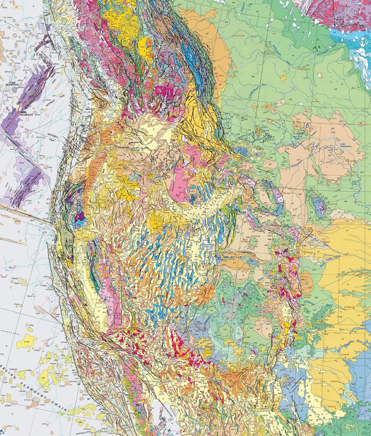
Cover. Geologic map of the western United States and surrounding areas, extracted from the “Geologic map of North America”
(Reed and others, 2005; database from Garrity and Soller, 2009). Image downloaded from the National Geologic Map Database
(https://ngmdb.usgs.gov/Prodesc/proddesc_86688.htm).
GeMS (Geologic Map Schema)—A
Standard Format for the Digital Publication
of Geologic Maps

By the U.S. Geological Survey National Cooperative Geologic Mapping Program

Chapter 10 of
Section B, U.S. Geological Survey Standards, of
Book 11, Collection and Delineation of Spatial Data

Techniques and Methods 11–B10

U.S. Department of the Interior
U.S. Geological Survey
U.S. Department of the Interior
DAVID BERNHARDT, Secretary
U.S. Geological Survey
James F. Reilly II, Director

U.S. Geological Survey, Reston, Virginia: 2020

For more information on the USGS—the Federal source for science about the Earth, its natural and living resources,
natural hazards, and the environment—visit https://www.usgs.gov or call 1–888–ASK–USGS (1–888–275–8747).
For an overview of USGS information products, including maps, imagery, and publications, visit https://store.usgs.gov.

Any use of trade, firm, or product names is for descriptive purposes only and does not imply endorsement by the
U.S. Government.

Although this information product, for the most part, is in the public domain, it also may contain copyrighted materials
as noted in the text. Permission to reproduce copyrighted items must be secured from the copyright owner.

Suggested citation:
U.S. Geological Survey National Cooperative Geologic Mapping Program, 2020, GeMS (Geologic Map Schema)—A
standard format for the digital publication of geologic maps: U.S. Geological Survey Techniques and Methods, book 11,
chap. B10, 74 p., https://doi.org/10.3133/tm11B10.

ISSN 2328-7055 (online)
iii

Acknowledgments
The GeMS database design is an outcome of years of research and collaboration by many
scientists and GIS specialists, under the auspices of numerous projects and initiatives. The
preparers of this document, Ralph A. Haugerud and David R. Soller (both USGS), especially
thank Peter Lyttle (former Program Coordinator, National Cooperative Geologic Mapping
Program) for his recommendation in 2008 that we undertake this work. We also thank our many
colleagues who have given thoughtful comments and critiques of this design.

Contents
Introduction.....................................................................................................................................................1
     Objective.................................................................................................................................................2
     Lessons Learned in the Last Three Decades....................................................................................2
Design Considerations...................................................................................................................................3
Content of a Geologic Map...........................................................................................................................3
     Extensions to Traditional Geologic Map Content.............................................................................5
           Glossary of Terms.........................................................................................................................5
           Classification of Geologic Materials.........................................................................................5
           Feature-Level Metadata..............................................................................................................6
                 Data Source (Provenance).................................................................................................6
                 Locational Confidence (Spatial Accuracy)......................................................................7
                 Scientific Confidence, Identity Confidence, and Existence Confidence....................8
                 Orientation Confidence.......................................................................................................8
           Working with Multiple Feature Attributes................................................................................8
     Naming Database Elements.................................................................................................................9
     Transparent Identifiers..........................................................................................................................9
     File Formats.............................................................................................................................................9
Required, As-Needed, and Optional Elements of a Digital Geologic Map Publication.....................10
The Database Design...................................................................................................................................10
     General Considerations......................................................................................................................10
           This Design Uses a Relational Database................................................................................10
           Field Hygiene...............................................................................................................................10
           Type, MapUnit, Label, and Symbol Fields...............................................................................12
           Polygons, Lines, and Topology—What Goes Where?..........................................................16
           Directional Lines.........................................................................................................................18
     Required Elements...............................................................................................................................18
           GeologicMap (Feature Dataset)...............................................................................................18
                 MapUnitPolys (Polygon Feature Class)..........................................................................18
                          Topology Rules..........................................................................................................18
                 ContactsAndFaults (Line Feature Class)........................................................................18
                          Topology Rules..........................................................................................................19
           DescriptionOfMapUnits (Nonspatial Table)............................................................................20
                 Notes on the Content of the Description Field..............................................................21
iv
Populating the DescriptionOfMapUnits Table...............................................................24
Order and Rank of Map Units..........................................................................................24
DataSources (Nonspatial Table)..............................................................................................24
GeoMaterialDict (Nonspatial Table)........................................................................................24
Glossary (Nonspatial Table)......................................................................................................24
As-Needed Elements..........................................................................................................................26
Guidelines for Naming and Designing Additional Feature Classes....................................26
Structure of Point Data..............................................................................................................27
Point Feature Classes in General....................................................................................27
Examples of As-Needed Point Feature Classes....................................................................27
OrientationPoints (Point Feature Class).........................................................................27
GeochronPoints (Point Feature Class)...........................................................................28
Stations (Point Feature Class).........................................................................................28
MapUnitPoints (Point Feature Class).............................................................................32
Examples of Other As-Needed Feature Classes...................................................................32
GeologicLines (Line Feature Class)................................................................................32
Topology Rules..........................................................................................................32
MapUnitLines (Line Feature Class).................................................................................32
Topology Rules..........................................................................................................32
CartographicLines (Line Feature Class).........................................................................32
IsoValueLines (Line Feature Class).................................................................................32
Overlay Polygons (the MapUnitOverlayPolys and OverlayPolys Polygon Feature
Classes)..................................................................................................................34
Topology Rules..........................................................................................................34
DataSourcePolys (Polygon Feature Class)....................................................................35
Topology Rules..........................................................................................................36
Symbolization................................................................................................................................................36
RepurposedSymbols (Nonspatial Table)..........................................................................................37
Shapefile Version of the Database............................................................................................................37
References Cited..........................................................................................................................................37
Appendix 1. Terms and Definitions for the GeoMaterial and GeoMaterialConfidence Fields.........40
Appendix 2. Optional Database Elements.................................................................................................49
Appendix 3. Parsing a Description of Map Units (DMU) into the DescriptionOfMapUnits Table
and the HierarchyKey Field...........................................................................................................53
Appendix 4. Frequently Asked Questions (FAQs) ...................................................................................61
Appendix 5. Changes from NCGMP09 v.1.1 to GeMS ............................................................................68v
Figures
1. ArcCatalog view of the contents of a GeMS-structured database, showing required,
as-needed, and optional database elements........................................................................................ 12
2. Entity-relationship diagram for selected polygon feature classes and associated nonspatial
tables, highlighting required and as-needed database elements................................................... 13
3. Entity-relationship diagram for selected line feature classes and associated nonspatial
tables, highlighting required and as-needed database elements................................................... 14
4. Entity-relationship diagram for selected point feature classes and associated nonspatial
tables, highlighting required and as-needed database elements..............................................15
3–1. Part of a modern Description of Map Units, excerpted from a geologic map published
relatively recently........................................................................................................................54
3–2. Reproduction of part of a map-unit explanation from a somewhat older geologic map,
showing an older style of map-unit description.......................................................................55
3–3. Part of a modern Correlation of Map Units diagram, excerpted from a geologic map
published relatively recently......................................................................................................56
3–4. Part of an older map-unit explanation, excerpted from an older geologic map, showing
an older, abbreviated style of map-unit description................................................................57
3–5. Part of a relatively modern Correlation of Map Units diagram, excerpted from a
geologic map published somewhat recently..........................................................................58
4–1. GeMS implementation of a stack-unit map that shows geologic materials to a depth of
20 ft, and the corresponding parts of tables MapUnitPolys, StackUnitsToMapUnits, and
DescriptionOfMapUnits................................................................................................................65
Tables
1. Example picklist of values for the LocationConfidenceMeters field................................................. 7
2. Example picklist of values for the IdentityConfidence field................................................................. 8
3. Elements of a digital geologic map publication named “mapXYZ”................................................. 11
4. Required, as-needed, and optional contents of the zip archive (that is, the
“mapXYZ-gdb.zip” file) that contains the database and other elements of the
digital data package for a geologic map publication named “mapXYZ”.............................. 11
5. Required, as-needed, and optional contents of the resources folder that accompanies the
database in a digital geologic map publication named “mapXYZ”................................................. 11
6. Examples of selected fields (and their values) in a DataSources table......................................... 16
7. Examples of selected fields (and their values) in a DescriptionOfMapUnits table..................... 16
8. Examples of selected fields (and their values) in a ContactsAndFaults feature class............... 16
9. Examples of selected fields (and their values) in an OrientationPoints feature class............... 16
10. Examples of values in the Type, Symbol, and Label fields in a point feature class and the
resulting map images.................................................................................................................................. 17
11. Examples of values in the MapUnit, IdentityConfidence, Symbol, and Label fields in the
MapUnitPolys feature class and the resulting map images............................................................. 17
12. Fields in MapUnitPolys (a polygon feature class in the GeologicMap feature dataset)........... 19
13. Fields in ContactsAndFaults (a line feature class in the GeologicMap feature dataset).......... 20
14. Fields in DescriptionOfMapUnits (a nonspatial table)........................................................................ 22
15. Fields in DataSources (a nonspatial table)............................................................................................ 25
16. Examples of records in a DataSources table........................................................................................ 25
17. Fields in GeoMaterialDict (a nonspatial table)...................................................................................... 25vi
18. Fields in Glossary (a nonspatial table)..................................................................................................... 26
19. Examples of records in a Glossary table................................................................................................ 26
20. Fields to be included in a typical point feature class.......................................................................... 28
21. Recommended additional fields to be included in a sample-oriented point feature class....... 28
22. Fields in OrientationPoints (an as-needed point feature class in the GeologicMap feature
dataset)............................................................................................................................................................ 29
23. Fields in GeochronPoints (an as-needed point feature class in the GeologicMap feature
dataset)............................................................................................................................................................ 30
24. Fields in Stations (an as-needed point feature class in the GeologicMap feature dataset).... 31
25. Examples of additional fields that might be included in a Stations point feature class............. 31
26. Fields in GeologicLines (an as-needed line feature class in the GeologicMap feature
dataset)........................................................................................................................................................... 33
27. Fields in CartographicLines (an as-needed line feature class in the GeologicMap feature
dataset)............................................................................................................................................................ 33
28. Fields in IsoValueLines (an as-needed line feature class in the GeologicMap feature
dataset)........................................................................................................................................................... 34
29. Fields in MapUnitOverlayPolys (an as-needed polygon feature class in the GeologicMap
feature dataset)............................................................................................................................................. 35
30. Fields in OverlayPolys (an as-needed polygon feature class in the GeologicMap feature
dataset)............................................................................................................................................................ 35
31. Fields in DataSourcePolys (an as-needed polygon feature class in the GeologicMap
feature dataset)............................................................................................................................................ 36
32. Fields in RepurposedSymbols (an as-needed nonspatial table)...................................................... 37
1–1. Values (and their definitions) that populate the GeoMaterialConfidence field in a
DescriptionOfMapUnits table.................................................................................................................. 41
2–1. Fields in CMUMapUnitPolys (a polygon feature class in the CorrelationOfMapUnits feature
dataset)............................................................................................................................................................ 50
2–2. Fields in CMULines (a line feature class in the CorrelationOfMapUnits feature dataset)......... 50
2–3. Fields in MiscellaneousMapInformation (a nonspatial table).......................................................... 51
2–4. Fields in StandardLithology (a nonspatial table)................................................................................... 51
2–5. Examples of records in a StandardLithology table.............................................................................. 52
3–1. Selected fields and values from a DescriptionOfMapUnits table for the Description of Map
Units depicted in figure 3–1........................................................................................................................ 54
3–2. Selected fields and values from a DescriptionOfMapUnits table for the explanation
depicted in figure 3–2................................................................................................................................. 55
3–3. Selected fields and values from a DescriptionOfMapUnits table for the Correlation of Map
Units diagram depicted in figure 3–3....................................................................................................... 56
3–4. Selected fields and values from a DescriptionOfMapUnits table for the explanation
depicted in figure 3–4................................................................................................................................. 57
3–5. Selected fields and values from a DescriptionOfMapUnits table for the Correlation of Map
Units diagram depicted in figure 3–5....................................................................................................... 59
4–1. Examples of selected fields (and their values) in LayerList (a nonspatial table), which
organizes and describes datasets within a multidataset map......................................................... 65GeMS (Geologic Map Schema)—A Standard Format for
the Digital Publication of Geologic Maps
By the U.S. Geological Survey National Cooperative Geologic Mapping Program
Introduction experience, evaluation, and discussion have led to this current
version,3 renamed as “GeMS,” for Geologic Map Schema.4, 5
This report1 describes and defines GeMS, a new standard- GeMS provides for the encoding in digital form of the
ized database schema—that is, a database design—for the content contained in geologic maps published by the USGS and
digital publication of geologic maps. It originally was intended by state geological surveys. It stipulates that an Esri database
for geologic mapping funded by the National Cooperative format be used, not only to adhere to USGS policy6 but also
Geologic Mapping Program (NCGMP) of the U.S. Geological because Esri’s ArcGIS is the most commonly used GIS in the
Survey (USGS), but its use can be extended to other programs USGS, in state geological surveys, and in the larger geologic
and agencies as well. It is intended to bridge the gap between mapping community. Nevertheless, migration to a nonpropri-
traditional geologic mapping and GIS communities at an opera- etary format is a worthy goal, and GeMS has been designed
tional level. with this in mind.
This schema was introduced at the Digital Mapping Although GeMS is designed for a single-map database, it
Techniques ’09 meeting (May 2009) for evaluation as version also is intended to provide a stepping stone toward the develop-
0.8.2, in order to solicit preliminary comments and testing; at that ment of multiple-map databases, in particular the National Geo-
time, it was named “NCGMP09” to reflect its target audience logic Map Database (NGMDB). The Geologic Mapping Act of
and the date of its initial release. Subsequently, version 1.0 was 1992, and its subsequent reauthorizations, mandate the creation
released October 14, 2009, for presentation at the Geological of a national archive of standardized geologic map content. The
Society of America’s 2009 Annual Meeting. In the months that NGMDB Project functions on behalf of the NCGMP as coordi-
followed, more extensive evaluations were received, and the nator of database design and maintenance, in cooperation with
design evolved in response: version 1.1[2] was published at the the Association of American State Geologists. The database
end of 2011 as an article in USGS Open-File Report 2010–1335 design contained herein will significantly promote that goal.
(U.S. Geological Survey National Cooperative Geologic Mapping All questions or comments about GeMS should be directed via
Program [USGS NCGMP], 2010). Several more years of email to gems@usgs.gov.
1
This report supersedes an article in USGS Open-File Report 2010–1335, Surveys), Lina Ma (Oregon Department of Geology and Mineral Industries), Phil
“NCGMP09—Draft Standard Format for Digital Publication of Geologic Maps, Miller (New Mexico Bureau of Geology & Mineral Resources), Bethany Overfield
version 1.1” (U.S. Geological Survey National Cooperative Geologic Mapping (Kentucky Geological Survey), Jay Parrish (Pennsylvania Geological Survey),
Program, 2010). Kevin Russell (Indiana Geological & Water Survey), Evan Thoms (USGS),
Frederic Wilson (USGS), Jeremy Workman (USGS), and Mark Yacucci (Illinois
2
Version 1.1 of this schema was prepared by (listed in alphabetical order)
State Geological Survey). GeMS will be maintained by the USGS National
R.A. Haugerud (USGS), S.M. Richard (Arizona Geological Survey; now at
Geologic Map Database Project; all correspondence should be addressed to gems@
USGIN Foundation), D.R. Soller (USGS), and E.E. Thoms (USGS).
usgs.gov.
3
The current document was prepared by Ralph A. Haugerud and David R. 4
NOTE: Earlier versions of this document and any updates, as well as further
Soller (both USGS), and it reflects significant input by numerous members of the
information on GeMS and resources such as an example database and tools, are
USGS–Association of American State Geologists–Digital Mapping Techniques
available at the GeMS website (https://ngmdb.usgs.gov/Info/standards/GeMS/).
community, specifically by the following members of the NCGMP09 Working
The current document is formally published at https://doi.org/10.3133/tm11B10.
Group (listed in alphabetical order), who should be considered as contributors:
Jennifer Athey (Alaska Division of Geological & Geophysical Surveys), Gregory
5
Note that the name GeMS has been used before in a similar context (see Dohar,
Barker (New Hampshire Geological Survey), Seth Bassett (Florida Geological 2004). We are pleased to reinforce GeMS as a useful acronym, and we think there
Survey), Jennifer Carrell (Illinois State Geological Survey), Lorie Coiner (Virginia is little likelihood of confusion.
Division of Geology and Mineral Resources), Mary DiGiacomo-Cohen (USGS), 6
USGS’ general policy is stated in USGS Policy 6.1.3, supplemented by USGS
John Dunham (Kansas Geological Survey), Tracey Felger (USGS), Trish Gallagher policy document “Requirements for Digital Map Products” (May 24, 1999,
(Alaska Division of Geological & Geophysical Surveys), Jacqueline Hamilton available at https://ngmdb.usgs.gov/Info/standards/dataexch/USGSpolicy.html;
(Minnesota Geological Survey), Jordan Hastings (University of California, see section 3, but please disregard reference to the Spatial Data Transfer Standard
Santa Barbara), Mike Hendricks (Alaska Division of Geological & Geophysical [SDTS], which is no longer applicable).2 GeMS (Geologic Map Schema)—A Standard Format for the Digital Publication of Geologic Maps
In our years of work prior to developing NCGMP09 and Lessons Learned in the Last Three Decades
GeMS, we recognized that one single database design cannot
suit all purposes, and this realization has been underscored Geologic map producers have been developing and using
by our colleagues’ evaluations of this design. In addition, we GIS representations of geologic maps for more than three decades.
acknowledge that a database most suited to the needs of a field In the course of this effort, we have all learned valuable lessons,
geologist likely will not address the content and cartographic some of which are listed below.
requirements of a single-map database that would be published Map data are most usefully stored, shared, and analyzed in a
for use by geologists and nongeologists alike, nor will it meet GIS.—Although paper maps can be represented digitally by scan-
the requirements of a multiple-map database that would be ning them and storing the resulting image files, this is only a very
maintained in perpetuity by a mapping agency. We further small step towards making the map and its constituent data more
recognize that, for any of these purposes, settling on one single easily accessible. Similarly, maps that are simply vector-graphic
database design may be contentious, in part owing to the vary- files (for example, those produced in desktop publishing software
ing requirements of other endeavors (for example, for field such as Adobe Illustrator) generally do not contain real-world, spa-
systems, for requirements imposed by local geology, or for tially explicit locations, nor do they explicitly state their thematic
particular hardware). Nevertheless, we have developed a design content and, thus, are not easily shared nor used for subsequent
that ought to be generally useful for most implementations, analysis. The most useful digital map data have feature attributes
while recognizing that many will not find it their first or best that are stored explicitly in database tables and feature locations
choice or that they may need to extend it to suit their purposes. that are provided in a real-world spatial reference framework (for
Compromise in design, without sacrificing the flexibility neces- example, UTM10, NAD83).
sary for science-driven data and information management, is The distinction between map data and their symbolization
the path we sought during development of the GeMS standard. is important.—Geologic map data primarily consist of feature
attributes in database tables (for example, line #27 is an accurately
located thrust fault; line #28 is an approximately located contact;
Objective line #29 is the shoreline of Lake Erie on August 27, 1978). Sym-
bolization of these data via line symbols, point symbols, colored
Geologic mappers, geologic mapping agencies, and areas, and patterns results in a map portrayal on screen or on paper.
geologic map users will all benefit from a standard database Storing map data in a GIS—as opposed to its symbolization in a
design for the digital representation of geologic maps. This drawing program—facilitates machine-assisted analyses of the
document describes such a design for the representation of a data, gives greater flexibility for alternate symbolization, and eases
single geologic map. The design is focused on the publication, reuse of the data at different scales.
transfer, and archiving of map data and less on the creation Maps in a GIS need to be accompanied by metadata for both
of map data, the visual representation of map data, or the the overall database and its individual features.—Early GIS prac-
compilation of data from many different map sources. With titioners, largely limited by both storage space and database archi-
increased use of this design, we anticipate reductions in the cost tecture, created a substantial number of map databases in which
of map preparation, production, and publication (including data key data fields were populated only by map-specific symbols that
compilation and synthesis, review, editing, cartography, prepress were not defined within the database (for example, a map unit was
work, training, and tool development). identified as “Ks” without specifying that “Ks” is shorthand for
For the purposes of this design, a single-map database “Cretaceous sandstone”); however, this approach is inadequate to
means a package of data (bearing in mind that many geologic effectively communicate the geology of an area. Mappers and map
map data are inherently interpretive) that pertains to a particular users benefit from feature-level metadata that describe both data
portrayal of the geology of a certain area (that is, the map source and quality. Reasons for such metadata include (1) most
extent), which is directly analogous to a traditional paper geologic maps contain data from mixed sources and of variable
geologic map. The database is attributed to an author or authors quality, (2) map data need to be closely linked to their authorship
who either have collected original data and developed the because such data mostly are interpretations made by authors, and
database and portrayal or have compiled data from existing (3) mapping commonly requires significant support from a gov-
sources and developed the portrayal. ernmental agency, an academic institution, a professional society,
We focus on the design of a single-map database for or private industry, and such support needs to be recognized.
two reasons: (1) it is the issue that the geologic community Real-world database designs reflect compromises between
understands best, and (2) it is the problem that we perceive is the intrinsic complexity of geologic map data, the needs of
most in need of a solution. The construction and maintenance of geologists and GIS practitioners who work with the design, the
an enterprise, multiple-map database raises several issues that capabilities of GIS and database software, and the limitations of
we do not address here, including versioning, multiple-scale the underlying computer systems.—Database designs that do not
representations, vocabulary management, maintenance of the make such compromises are not likely to be widely used. Even the
stratigraphic lexicon, and access control. names of various database elements (spatial featuresets, tables, andContent of a Geologic Map 3
fields) must be carefully crafted to be understood by users who • Introduce standardized terminology and definitions to
have different backgrounds, to facilitate the adaptation and reuse address the perception that traditional geologic maps do
of software tools, and to promote the distribution, translation, and not meet the public’s (nor the scientist’s) need for consis-
compilation of data. tently named and defined earth materials.
Obtaining widespread community acceptance for a
particular database schema and its associated vocabularies, • Preserve and facilitate the analysis of map-feature topology.
which may extend beyond the precedents set by traditional • Normalize map data for robustness and compactness, but
mapping methods, is difficult.—Although this conservatism not to the extent that user comprehension is reduced.
may be a good thing because our mapping traditions embody a
great deal of hard-won wisdom, it is also unfortunate because • Allow the descriptions of map features to be queried with
these traditions incorporate prior compromises, necessitated by as much (or as little) granularity or detail as desired.
the limitations of nondigital formats, that are unnecessary in a
• Facilitate the reuse of map data in later compilations by
digital world.
including feature-level metadata.
And finally, a perception persists among some geologists that
the comprehension of their maps may be beyond the capabilities • Accommodate both Esri and open file formats for flexibil-
of the uninitiated and that, therefore, these maps cannot—and ity, interoperability, and data longevity.
should not—be expected to be readily useable by members of the
public.—This is unfortunate because it is the public who needs
the maps (and who have paid for them). As noted by then–USGS
Director John Wesley Powell, “maps [need to be] designed not so Content of a Geologic Map
much for the specialist as for the people, who justly look to the
official geologist for a classification, nomenclature, and system of Geologic maps are rich in semantic content, fundamental
convention so simple and expressive as to render his work imme- aspects of which must be preserved in a database for it to be
diately [understandable]” (Powell, 1888). useful. Such fundamental content appears in MAGENTA ALL
We have endeavored to honor these lessons when designing CAPS bold type in the outline below. Items in BLACK ALL
the GeMS database schema, and we hope that the schema will CAPS bold type are secondary or supporting content. Digital
contribute to a better understanding, and the wider use, of geologic forms for both primary and secondary content are further dis-
map data. cussed below where the GeMS schema is described in detail.
Items in black italic bold type are secondary or supporting content
for which a digital form is not specified herein.
Design Considerations 1. MAP GRAPHIC—Consists of some or all of the following:
A. Base map—Graphical elements that provide spatial
Within GeMS, we have attempted to do the following:
and cultural context for map data at a certain scale (for
• Encode the fundamental content of a single, traditional example, shaded relief, topographic and (or) bathy-
paper geologic map. metric contours, drainage features, township and range
grid, transportation network, cultural features, place
• Focus equally on both the digital storage and the digital names); although not required, inclusion of a base map
transfer of map data. is strongly recommended.
• Facilitate editing of the map (for example, all lines that B. MAP-UNIT POLYGONS—Polygons that cover the
bound map-unit polygons are in the same layer to facilitate map area with no gaps or overlaps; may include areas
enforcement of topological constraints). of open water, permanent snowfields and glaciers, and
unmapped areas.
• Facilitate the interactive display and query of map data.
C. CONTACTS AND FAULTS—Lines that, with a few
• Provide a foundation for the publication-quality visualiza- exceptions, bound and separate map-unit polygons.
tion of the map data.
D. Other elements that are present as needed to record
• Define the names and types of data (feature datasets, significant map content:
feature classes, nonspatial tables,7 fields, and attributes) for
all constituent elements of the map, using names that have I. ORIENTATION DATA—Point features that
obvious meaning to geologists and GIS practitioners alike, record measurements of the orientation of rock
both for the convenience of all users and as a springboard fabrics (for example, bedding, foliation, paleo-
for development of software tools. currents, magnetic anisotropy).
7
A nonspatial table is one that contains no spatial (geographic) references.4 GeMS (Geologic Map Schema)—A Standard Format for the Digital Publication of Geologic Maps
II. OVERLAY POLYGONS—Areal features that F. POINT SYMBOLS—Note that not all points in the
overlie, underlie, are within, or cut across map- database need be symbolized.
unit polygons (for example, shear zones, alteration
zones, areas of artificial fill, surface projections of G. FONT FILES—If needed for point symbols or
mined-out areas); need not conform to topological line-symbol ornaments.
rules that constrain map-unit polygons; and are H. Text labels (or, in some cases, labels and leaders)
commonly represented by patterned overlays for some lines and groups of lines and for some
whose boundaries are not drawn. points (for example, fault names, well identifiers).
III. MAP-UNIT LINES AND POINTS—Line or 5. DESCRIPTION OF MAP UNITS (DMU)—Contains
point features that represent map units that are too labels, names, ages, and descriptions for each map unit
small to show at scale of map graphic. shown on the map or in a cross section:
IV. MISCELLANEOUS LINES—Line features • A DMU contained on a map sheet will show, in addition to
not categorized above (for example, dikes and the map-unit label, the area-fill symbol (color and some-
sills, marker beds, traces of fold hinges, facies times a pattern) used to depict the unit on the map.
boundaries, structure contours, isograds, cross-
section lines). • In some map reports, the DMU is not printed on the map
sheet but, instead, is contained in an accompanying pam-
V. MISCELLANEOUS POINT DATA—Point phlet; in these DMUs, typically only the map-unit label is
features that record, for example, sample localities shown, without color or pattern.
for geochronologic and chemical analyses, fossil
localities, prospect locations, and displacement • DMUs can be strongly hierarchical, using headings (for
(fault-slip) measurements. example, “Unconsolidated Deposits”) and paragraph
styles (font size and style, indentation) to denote each
2. CROSS SECTIONS, as appropriate—Each cross sec- unit’s position in the hierarchy.
tion has elements that are analogous to those of the map
(listed above), except that the base map is replaced by a • DMUs may include bracketed headnotes (for example,
topographic profile. “[Modified from Booth and others (2009)]”).
3. CORRELATION OF MAP UNITS (CMU)—Diagram • DMUs sometimes contain units that are not shown on
that depicts the ages and relations of (and among) map the map or cross section (for example, a formation that is
units; may include headings and grouping brackets; mapped entirely as its constituent subunits); such units will
sometimes shows nonconformities or additional data lack a map-unit label and an area-fill color or pattern in
such as radiometric ages; is not intended to be a true the DMU (because they are not depicted on the map), but,
stratigraphic section or column; usually does not include in order to fully communicate stratigraphic relations, their
areas of open water, permanent snowfields and glaciers, names and ages are listed in the DMU and their positions
or unmapped areas. in the hierarchy are indicated.
4. SYMBOLIZATION for all of the above, including the • DMUs typically do not describe areas of open water,
following: permanent snowfields and glaciers, unmapped areas, and
certain geologic overlays.
A. FILLS (COLORS AND OPTIONAL PATTERNS)
for map-unit polygons. 6. List of Map Units (LMU), if applicable—A distillation of
the DMU, placed on the map sheet as a key to help iden-
B. FILLS (PATTERNS) for overlay polygons. tify map units when the DMU is contained in an accom-
panying pamphlet; an LMU contains the same map-unit
C. LINE SYMBOLS AND (OR) POINT SYMBOLS labels, names, and ages as does the DMU but not the
for map-unit areas too small or narrow to show as full map-unit descriptions; an LMU also uses the same
polygons at map scale. hierarchical elements (headings, type styles, indentations,
and so on) as the DMU.
D. Text labels (or, in some cases, labels and leaders)
for some (but not necessarily all) polygons. 7. EXPLANATION OF MAP SYMBOLS—Contains
descriptions of line symbols, point symbols, and overlay
E. LINE SYMBOLS HAVING VARIOUS COLORS, patterns but (typically) not symbols for base-map features;
WEIGHTS, AND PATTERNS (DASHES, DOTS)— map-symbol explanations can be hierarchical.
Some line symbols contain repeated ornaments (for
example, thrust teeth, queries), and some have single 8. MISCELLANEOUS MAP-COLLAR INFORMA-
(nonrepeating) ornaments. TION—Consists of information such as report title,Content of a Geologic Map 5
author(s), date of publication, publisher, series name Formal metadata for a feature class or table can then reference the
and series number, map scale, various credit notes (for Glossary table for definitions and definition sources; therefore,
example, “mapped by”, “edited by”, “GIS database by”, relisting these definitions within detailed entity and attribute
“cartographic production by”), and base credit note (for metadata is not necessary. Terms used only in the Description field
example, specification of spatial reference framework or of a DescriptionOfMapUnits table need not be defined.
projection, source[s] and scale[s] of base map); content If populating the Glossary table seems excessively laborious,
may vary from agency to agency, from one mapper to consider that, once terms are defined in a Glossary table, they are
another, and from one map to another. readily available for display within the map, either on screen or in
print. Furthermore, they can be easily searched for and extracted
9. Discussion. for use in other publications. In most cases, definitions in the Glos-
sary table can be copied directly (or paraphrased) from standard
10. References Cited.
reference sources (for example, American Geosciences Institute’s
11. Figures(s), if applicable. [AGI’s] “Glossary of Geology (5th ed., revised)”; Neuendorf and
others, 2011), with appropriate attribution, or from preexisting
12. Tables(s), if applicable. GeMS Glossary tables, with minor adjustments or amendments.
Although building Glossary tables for the first few maps produced
13. Additional map (s), if applicable—For example, sources of by a workgroup will be a significant effort, subsequent Glossary
map data, distribution of facies in the Cambrian. tables ought to become much easier to develop as content from
It is worth noting that, in general, populating the database by previous Glossary tables is reused.
assigning values to feature attribute fields is the responsibility of
the database creator. In some cases, this may require manual entry
of individual attribute values for each feature. However, in many Classification of Geologic Materials
cases, such assignments can be made in bulk or can be scripted, A DMU conveys essential information about each map unit
as noted below (see, for example, the scripts GeMS_SetSymbols_ and is a cornerstone of the GeMS design. However, descriptions
Arc10.py and GeMS_SetPlotAtScales_Arc10.py; both of these, in a DMU can vary greatly in their content and format, and they
or their replacements, are available at https://github.com/usgs/ commonly use specialized terminology that may be unfamiliar
GeMS_Tools). to the nongeologist. In addition, terminology may be used
inconsistently from map to map (usually for valid reasons). Over
time, many attempts have been made to organize and standardize
Extensions to Traditional Geologic Map Content descriptions of geologic materials, with the goals of improving
GeMS includes several extensions to traditional geologic our abilities to make regional compilations and to more effectively
map content. The following three are required: (1) a glossary of convey geologic information to the public. Of necessity, such
terms, (2) a simple classification of map-unit materials, and (3) efforts are compromises that only partly describe the nearly
certain feature-level metadata. Optional extensions may include infinite variety of map-unit ages, compositions, textures, modes of
supplemental standardized lithologic descriptions of map units and genesis, and appearances.
a simple table of miscellaneous map information. In 2004, the North American Geologic Map Data Model
Steering Committee (see https://ngmdb.usgs.gov/www-nadm/)—
sponsored by the USGS, the Association of American State Geolo-
Glossary of Terms gists, and the Geological Survey of Canada—defined a general,
conceptual data model for geologic maps, as well as a science
Many published digital geologic map databases, and many language for describing various characteristics of earth materi-
paper geologic maps as well, provide few, if any, definitions als. Their summary report on science language (North American
for the technical terms used to name and describe map features. Geologic Map Data Model Steering Committee Science Language
Some producers of geologic map databases have remedied this by Technical Team, 2004) presented classifications that have since
providing formal Federal Geographic Data Committee (FGDC) been evaluated and adapted for many purposes; for example, the
metadata, which can contain detailed entity and attribute descrip- IUGS-CGI8 Geoscience Concept Definitions Working Group
tions that encapsulate definitions (and definition sources) for these incorporated that work into a limited set of lithology categories
terms. Unfortunately, such metadata can be difficult to access and (“SimpleLithology”) for use in GeoSciML9 interchange docu-
nearly impossible to relate automatically to the relevant features in ments (see http://resource.geosciml.org/def/voc/).
a database.
GeMS implements a Glossary table that, for certain database
fields, lists the terms that populate these fields, along with their
definitions and the sources for these definitions. Terminology 8
IUGS, International Union of Geological Sciences; CGI, Commission for
used in these database fields must be defined in this Glossary the Management and Application of Geoscience Information.
table. Contents of the Glossary table may be accessed by means 9
GeoSciML is an XML-based data transfer standard for the exchange of
of a database join (or relate) that is based on the term itself. digital geoscientific information.6 GeMS (Geologic Map Schema)—A Standard Format for the Digital Publication of Geologic Maps
A similar list of terms (“StandardLithology”) accompanied For some purposes, a single, standard earth-materials
the initial release of NCGMP09 (version 1.0, October 2009). As classification may not adequately address the geology of a
with SimpleLithology, the StandardLithology list of terms was given region in sufficient detail. Therefore, scientists may
designed to be used with companion lists of proportion terms or wish to attach a terminology to their research databases that
values to encode the relative amounts of potentially numerous is more detailed and structured than what is stipulated in
lithologies that could be found in each map unit. This approach GeMS. A more structured controlled-term list, for example,
encouraged multiple lithology entries for a map unit, thereby might be desired in order to query a database for minor
allowing detailed descriptions of map units. However, the level of lithologies within a map unit that are not adequately indicated,
effort required to populate StandardLithology was judged by many either by the map-unit name, its GeoMaterial term, or its
reviewers of version 1.0 to be too high. Therefore, this approach Description in the DescriptionOfMapUnits table. In such
was abandoned for version 1.1 of NCGMP09 (and for GeMS). cases, evaluation of the salary and programming costs versus
Nevertheless, we remain convinced that standardized the research and societal benefits of including supplemental
terminologies are beneficial, largely because of their potential data tables and vocabularies may motivate a mapping project
to do the following: to extend the GeMS schema; if so, we advocate using either
• Allow more uniform portrayal of rock and sediment an optional table of the geologist’s own design or the optional
types across multiple maps. StandardLithology table (described in appendix 2).
• Facilitate queries for the presence of a particular rock type.
For example, by using a hierarchical classification, both the Feature-Level Metadata
queried rock type and its related rock types can be found. All features in a geologic map database should be accom-
For example, if “lava flows” is queried, then both “felsic panied by an explicit record of the data source. Many features
lava flows” and “igneous rock” may also be returned. should also be accompanied by explicit statements of scientific
Bearing in mind the importance of providing the public a confidence—for example, how confident is the author that a
simple, systematic view of the Nation’s geology, NCGMP09 v.1.1 feature exists? Or that it is correctly identified? How confidently
included, and GeMS retains, a simplified classification of earth are feature attributes known? We recognize that these are challeng-
materials that is based on general lithologic and genetic character. ing questions to which the field geologist may not be comfortable
This classification (called GeneralLithology in NCGMP09 but providing an answer, except in the most general sense. But we
renamed GeoMaterial in GeMS) applies a single term to each also recognize that geologic information commonly is used in a
map unit, providing information that a nonexpert could quickly GIS in conjunction with other types of information (for example,
use to identify map units that contain similar materials. Although cadastral surveys, road networks, pipelines) and that terms such
GeoMaterial is a required field in GeMS, its content is not intended as “accurately located” have a markedly different meaning for
to be a substitute for the more detailed and precise lithologic a pipeline or property line than for a geologic contact. Thus, in
terminology that would be included in a DMU or in a more detailed order to provide a general indication of the scientific (existence
and specialized controlled-term list; rather, its purpose is as stated and identity) confidence and locational accuracy of geologic-map
briefly above (and also as discussed in detail in Soller, 2009). features, GeMS implements per-feature descriptions of scientific
The GeoMaterial classification, which has been developed confidence and locational accuracy. For more discussion on this
empirically, is based on commonly occurring geologic materials. topic, please see Section 4 in the introductory text of the “FGDC
It serves to organize the many and varied geologic material terms Digital Cartographic Standard for Geologic Map Symbolization”
found in the source maps, which represent a wide range of geo- (Federal Geographic Data Committee [FGDC], 2006, available
logic conditions across the Nation, in order to provide a consistent online at https://ngmdb.usgs.gov/fgdc_gds/geolsymstd.php; see
means of displaying map-unit materials. It was initially developed also U.S. Geological Survey, 2006). The following sections dis-
for the NGMDB Data Portal, a prototype site (ca. 2008) intended cuss the feature-level metadata required in GeMS.
to raise discussion with NGMDB partners in the state geological
surveys regarding how to provide the public with an integrated
Data Source (Provenance)
view of regional-scale geologic maps, with links to the source-map
information. Documentation of the original term list, including the Typically, a single map database will have very few data-
rationale, was provided in Soller (2009). The GeneralLithology source records because many features will have identical sources.
classification in version 1.1 of NCGMP09 was slightly modified For a database composed entirely of new mapping, a single data
from the original, and it has been further modified (slightly) on source may be cited (“this report”). Some data elements will have
the basis of six years of evaluation and test implementation by the compound sources: for example, geochemical analysis of a rock
state geological surveys and USGS. For inclusion in this version sample will typically have one source for the map location and
(version 2, GeMS), it has been renamed GeoMaterial. Note that, stratigraphic provenance of the sample (that is, the field geologist’s
given the lengthy period of evaluation, as well as the inherent chal- reported data) and another source for the chemical analysis (that
lenges in modifying a controlled-term list (for example, updating is, the geochemist’s reported data). In such cases, having multiple
previously published databases to a revised classification), we do source fields in the data table would be appropriate (for example,
not anticipate modifications to this list in the near future. LocationSourceID and AnalysisSourceID).You can also read