TMS VCL WebGMaps DEVELOPERS GUIDE - TMS Software
←
→
Page content transcription
If your browser does not render page correctly, please read the page content below
TMS SOFTWARE
                            TMS VCL WebGMaps
                            DEVELOPERS GUIDE

TMS VCL WebGMaps
DEVELOPERS GUIDE

                                  February 2019

  Copyright © 2012-2019 by tmssoftware.com bvba
              Web: http://www.tmssoftware.com
                    Email: info@tmssoftware.com

  1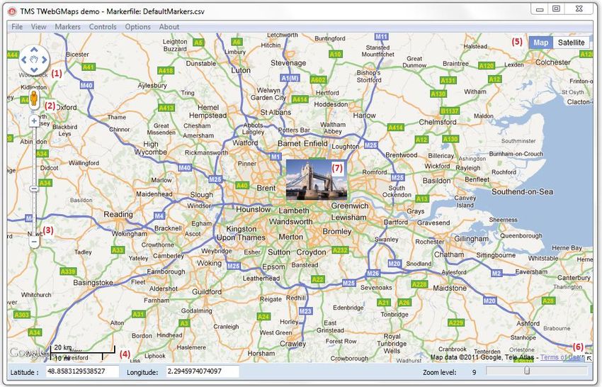
TMS SOFTWARE
                                                                                                                             TMS VCL WebGMaps
                                                                                                                             DEVELOPERS GUIDE

Table of contents
Introduction .............................................................................................................................................4
Availability ................................................................................................................................................4
Terms of use .............................................................................................................................................5
List of included components ....................................................................................................................6
Online references .....................................................................................................................................6
   TWebGMaps authentication ............................................................................................................... 7
   TWebGMaps description ..................................................................................................................... 7
   TWebGMaps features ......................................................................................................................... 8
   TWebGMaps architecture ................................................................................................................. 10
   TWebGMaps use ............................................................................................................................... 10
       Getting started .............................................................................................................................. 10
       View Types..................................................................................................................................... 14
   General map settings ........................................................................................................................ 18
       TWebGMaps properties ................................................................................................................ 18
       TWebGMaps.MapOptions properties ........................................................................................... 19
       TWebGMaps.StreetViewOptions properties................................................................................. 22
       TWebGMaps.WeatherViewOptions properties ............................................................................ 23
   Map markers ..................................................................................................................................... 24
       Adding markers ............................................................................................................................. 24
       TWebGMaps.Markers properties .................................................................................................. 25
   Map clusters ...................................................................................................................................... 29
       Adding clusters .............................................................................................................................. 30
       TWebGMaps.Clusters properties .................................................................................................. 32
       TWebGMaps.Clusters methods..................................................................................................... 34
   Map directions .................................................................................................................................. 34
       Retrieving directions ..................................................................................................................... 34
       TWebGMaps.Directions properties ............................................................................................... 35
   Map polygons .................................................................................................................................... 38

                                                                             2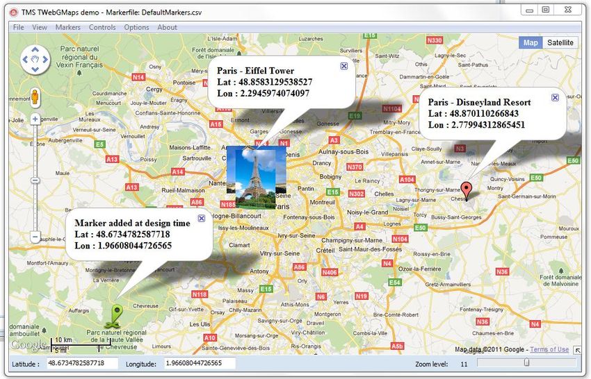
TMS SOFTWARE
                                                                                                                      TMS VCL WebGMaps
                                                                                                                      DEVELOPERS GUIDE

   Adding polygons ............................................................................................................................ 38
   TWebGMaps.Polygons properties................................................................................................. 40
Map polylines .................................................................................................................................... 42
   Adding polylines ............................................................................................................................ 42
   TWebGMaps.Polylines properties ................................................................................................. 44
Map ControlsOptions ........................................................................................................................ 46
   TWebGMaps.ControlsOptions properties ..................................................................................... 46
Map elevations .................................................................................................................................. 50
Map routing ....................................................................................................................................... 51
Map methods .................................................................................................................................... 53
Map events ........................................................................................................................................ 58
   Panning the map ........................................................................................................................... 65
   Zooming the map .......................................................................................................................... 65
TWebGMapsGeocoding component ................................................................................................. 69
TWebGMapsReverseGeocoding component .................................................................................... 70
TWebGMapsDirectionList component .............................................................................................. 74
TWebGMapsTimeZone component .................................................................................................. 74
TWebGMapsDialog component ........................................................................................................ 76
TWebGMaps demo............................................................................................................................ 79

                                                                        3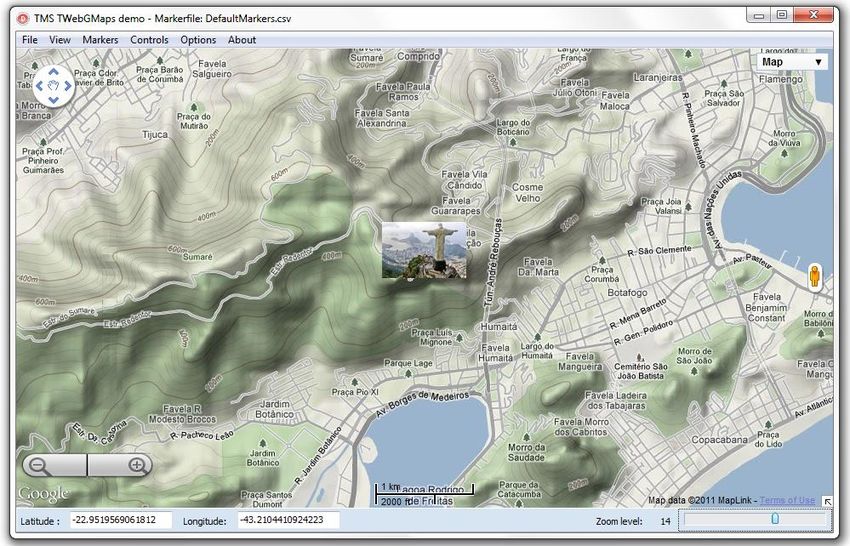
TMS SOFTWARE
                                                                                 TMS VCL WebGMaps
                                                                                 DEVELOPERS GUIDE

Introduction

The TMS VCL WebGMaps is a component that allows integration of the Google Maps road map
control. The TWebGMaps component renders maps of different types: default roadmap view,
satellite view, hybrid view (a mix of satellite view with roadmap information), and terrain
(topographic style map). TWebGMaps offers pan, zoom and scale control.

In this document you will find an overview of the TWebGMaps component and its features, code
snippets to quickly start using the component and overviews of properties, methods and events.

Availability
TWebGMaps and its helper components are available as VCL component for Delphi and C++Builder.

TWebGMaps is available for Delphi 2007, 2009, 2010, XE, XE2, XE3, XE4, XE5, XE6, XE7, XE8, 10
Seattle, 10.1 Berlin,10.2 Tokyo & C++Builder 2007, 2009, 2010, XE, XE2, XE3, XE4, XE5, XE6, XE7, XE8,
10 Seattle, 10.1 Berlin,10.2 Tokyo and can be used for Win32 and Win64 application development *.

TWebGMaps has been designed for and tested with: Windows 2003, Windows Vista, Windows 2008,
Windows 7, Windows 8, Windows 10.

*Win64 development requires RAD Studio XE2 or newer versions.

                                                  4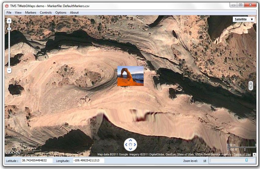
TMS SOFTWARE
                                                                                 TMS VCL WebGMaps
                                                                                 DEVELOPERS GUIDE

Terms of use

With the purchase of TWebGMaps, you are entitled to our consulting and support services to
integrate the Google Maps service in Delphi or C++Builder applications and with this consulting and
support comes the full source code needed to do this integration. As TWebGMaps uses the Google
Maps service, you're bound to the terms of this Google service that can be found at:

http://code.google.com/apis/maps/terms.html

http://maps.google.com/help/terms_maps.html

TMS software is not responsible for the use of TWebGMaps. The purchase of TWebGMaps does not
include any license fee that you might possibly be required to pay to Google. It will depend on your
type of usage of the Google Maps service whether a license fee needs to be paid to Google.
It is the sole responsibility of the user or company providing the application that integrates the
Google maps service to respect the Google terms and conditions . TMS software does not take any
responsibility nor indemnifies any party violating the Google maps service terms & conditions.

Limited warranty

TMS software cannot guarantee the current or future operation & uptime of the Google maps
service. TMS software offers the consulting and support for TWebGMaps in good faith that the
Google maps service is a reliable and future-proof service. In no case, TMS software shall offer
refunds or any other compensations in case the Google maps service terms/operation changes or
stops.

                                                  5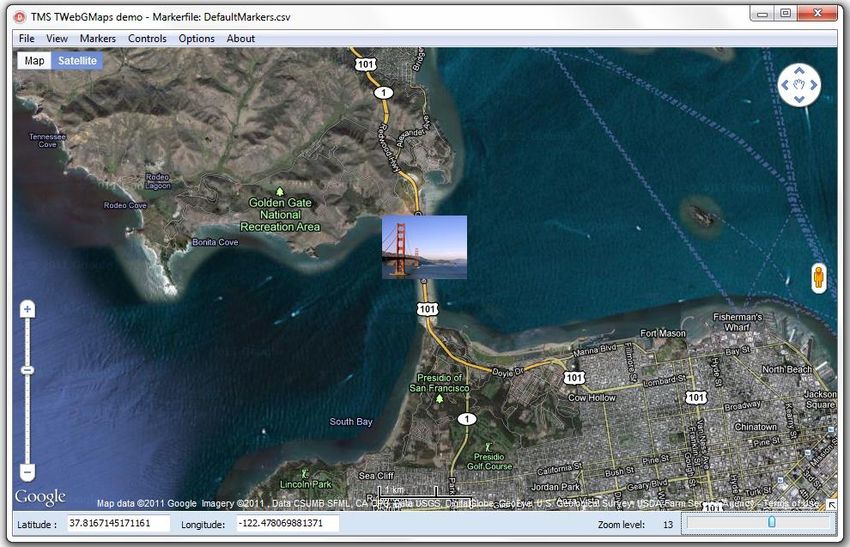
TMS SOFTWARE
                                                                               TMS VCL WebGMaps
                                                                               DEVELOPERS GUIDE

List of included components
TWebGMaps is the core map component.
TWebGMapsGeoCoding is the component to convert an address to longitude & latitude coordinate.
TWebGMapsReverseGeoCoding is the component to convert a longitude & latitude coordinate to an
address.
TWebGMapsLookupEdit is a helper component that allows entering addresses with auto completion
based on information from Google Maps.
TWebGMapsDirectionList is a helper component that allows to display a list of steps of a route with
HTML formatted text.
TWebGMapsTimeZone is the component that allows to lookup time zone information based on a
longitude & latitude coordinate.

Online references

TMS software website:
http://www.tmssoftware.com

TMS VCL WebGMaps page:
http://www.tmssoftware.com/site/webgmaps.asp

                                                 6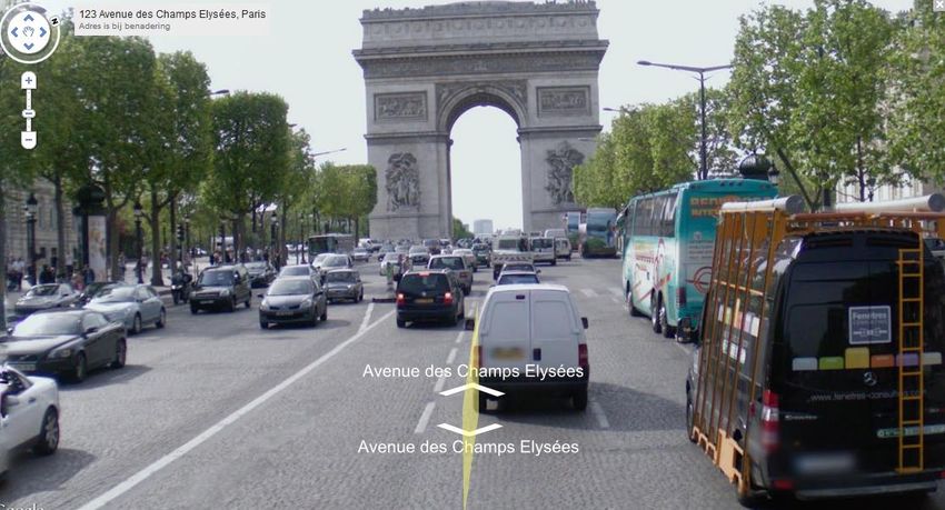
TMS SOFTWARE
                                                                                 TMS VCL WebGMaps
                                                                                 DEVELOPERS GUIDE

TWebGMaps
TWebGMaps authentication

It is recommended to use an API Key to authenticate your application with the Google Maps
JavaScript API service. Retrieving an API Key is free and can be obtained at the Google Developers
Console.
Instructions can be found on this page:
https://developers.google.com/maps/documentation/javascript/get-api-key

Make sure to enable the following APIs in Google’s Console:

    -   Google Maps JavaScript API

    -   Google Maps Directions API

    -   Google Maps Geocoding API

    -   Google Maps Geolocation API

    -   Google Maps Elevation API

The API Key should be assigned to the APIKey property, one time before the map is loaded, in the
Form’s OnCreate event of an application.

Example:
procedure TForm1.FormCreate(Sender: TObject);
begin
   WebGMaps1.APIKey := 'myAPIKey';
end;

When using the TWebGMapsGeocoding and/or TWebGMapsReverseGeocoding controls the API Key
should be assigned the respective APIKey properties as well.

Example:
procedure TForm1.FormCreate(Sender: TObject);
begin
   WebGMapsGeocoding1.APIKey := 'myAPIKey';
   WebGMapsReverseGeocoding1.APIKey := 'myAPIKey';
end;

TWebGMaps description

                                                  7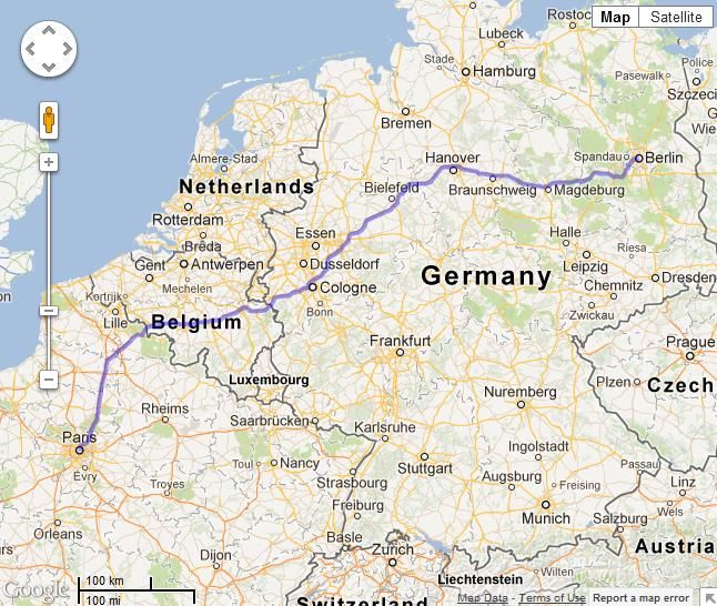
TMS SOFTWARE
                                                                                 TMS VCL WebGMaps
                                                                                 DEVELOPERS GUIDE

The TMS VCL WebGMaps is a mapping component to integrate for display & control Google Maps in
a VCL Windows application. It supports the default roadmap view, satellite view, hybrid view, and
terrain view. The TWebGMaps component offers pan, zoom and scale control. An overview-map is
integrated for faster panning. Street view offers a life-like 3D experience (where available).
Markers can be added to the map via the longitude/latitude coordinates or via an address. Various
marker types exist: default balloon marker, image marker, text marker, marker with hint. Markers
can also be displayed with a custom HTML label.
Polylines can be added to the map via a Path, which is a collection of longitude/latitude coordinates.
Polygons can be added to the map via longitude/latitude coordinates. Various polygon types exist:
custom polygon, circle or rectangle.
Directions can be retrieved via start and destination address. Directions can also be displayed on the
map.
Screenshots of the displayed map can be saved to .BMP, .JPG and .PNG files.
A separate component TWebGMapsGeocoding is available to perform address to longitude/latitude
conversions.
A separate component TWebGMapsLookupEdit is available that allows to enter addresses with auto
completion based on information from Google Maps.
A separate component TWebGMapsDirectionList is available that allows to display a list of steps of a
route with HTML formatted text.

TWebGMaps features

    -   Different map modes are available: default road map, satellite view, hybrid view (mixed
        satellite/roadmap view), terrain (topographic style map) or Google streetview (where
        available).

    -   Image files can be created of the maps displayed. These can be saved in different formats:
        .BMP, .JPG or .PNG.

    -   Extra map information can be displayed: Bicycle View, Panoramio (pictures-) information,
        Traffic information.

    -   Position markers can be added to the maps. Markers are displaying additional information on
        the marker position when clicked. Markers can be default balloons or custom images.

    -   Markers is a collection of positions that are indicated on the map. Markers are based on
        longitude and latitude coordinates.

    -   Moving over a marker can optionally display a hint with the marker title information.

    -   A custom HTML label can optionally be displayed on top of a Marker.

                                                  8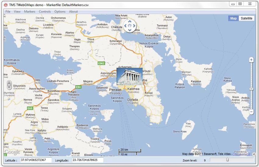
TMS SOFTWARE
                                                                                TMS VCL WebGMaps
                                                                                DEVELOPERS GUIDE

-   Polylines is a collection of lines that are displayed on the map. Polylines are based on a list of
    longitude and latitude coordinates.

-   Polygons is a collection of closed lines with a filled region that are displayed on the map.
    Polygons are based on a list of longitude and latitude coordinates (for Polygons of type
    ptPath), a center point and radius (for Polygons of type ptCircle) or two longitude and
    latitude coordinates (for Polygons of type ptRectangle).

-   Directions is a collection of routes between a start location and a destination address.

-   Different controls are available and can be turned on or off. MapType control, OverViewMap
    control, Pan control, Scale control, StreetView control and Zoom control. The position on the
    screen of the control as well as the visibility and in some cases the style can be defined.

-   Different mouse and keyboard options are available: dragging of the map, enabling/disabling
    all controls, enabling/disabling zoom on double clicking the mouse, enabling/disabling the
    mouse scroll wheel and enabling/disabling the keyboard.

-   TWebGMapsGeocoding is a separate component that takes an address as input and converts
    this to longitude and latitude.

-   TWebGMapsReverseGeocoding is a separate component that takes a longitude and latitude
    coordinate as input and converts this to an address.

-   TWebGMapsLookupEdit is a separate component that can perform auto completion of
    address entry via the Google Maps service. It is required to have a Google API key for this.

-   TWebGMapsDirectionList is a separate component that can display the different steps of a
    route with HTML formatting.

-   TWebGMapsTimeZone is a separate component that can lookup time zone information
    based on a longitude & latitude coordinate.

                                                9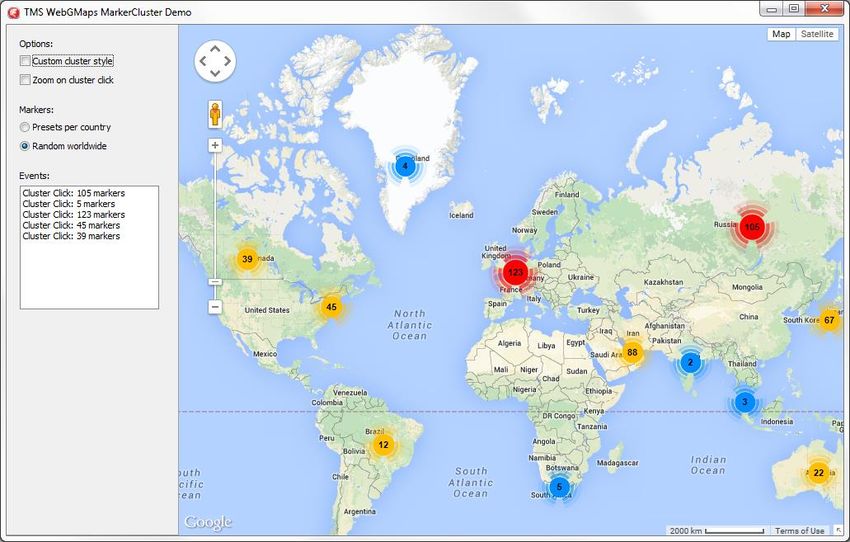
TMS SOFTWARE
                                                                                 TMS VCL WebGMaps
                                                                                 DEVELOPERS GUIDE

TWebGMaps architecture

The core part of the TMS WebGMaps is the TWebGMaps control, a VCL component integrating the
Internet Explorer browser and exposing properties, methods and events to control Google Maps.
Additional Google Maps controls can be optionally enabled on the map, i.e. a PanControl (1), a
StreetViewControl (2), a ZoomControl (3), a ScaleControl (4), a MapTypeControl (5) and an
OverviewmapControl (6).

Different markers (7) can be added to display preferred locations. The marker can display a default
balloon or when a valid URL is provided, an image or icon is displayed.

Various events are triggered when the user interacts with keyboard or mouse with the map.

TWebGMaps use

Getting started

From the component palette, select TWebGMaps and drop it on a form. This shows an empty map.
The map is only displayed when WebGMaps.Launch is called. The default center location displayed
when WebGMaps.Launch is called is set by: WebGMaps.MapOptions.DefaultLongitude,

                                                 10
TMS SOFTWARE
TMS VCL WebGMaps
DEVELOPERS GUIDE
WebGMaps.MapOptions.DefaultLatitude.
Markers can be added to the map by adding a new entry to the collection WebGMaps.Markers and
setting the Marker’s properties Longitude & Latitude.
This code snippet sets up the default view of the TWebGMaps to show the Los Angeles Theatre on
Broadway at zoom level 19 with coordinates retrieved from the TWebGMapsGeocoding component:
begin
WebGMapsGeocoding1.Address := 'Broadway 615, LOS ANGELES, USA';
if WebGMapsGeocoding1.LaunchGeocoding = erOk then
begin
// center the map at the coordinate
WebGMaps1.MapOptions.DefaultLatitude :=
WebGMapsGeocoding1.ResultLatitude;
WebGMaps1.MapOptions.DefaultLongitude :=
11TMS SOFTWARE
TMS VCL WebGMaps
DEVELOPERS GUIDE
WebGMapsGeocoding1.ResultLongitude;
// Add a marker for the Los Angeles theatre
WebGmaps1.Markers.Add(WebGMapsGeocoding1.ResultLatitude,
WebGMapsGeocoding1.ResultLongitude,'Broadway theatre');
// set zoom level
WebGmaps1.MapOptions.ZoomMap := 19;
// launch the display of the map
WebGMaps1.Launch;
end;
end;
Further to this, we can take a look at the Los Angeles theatre by switching the map to StreetView.
Following code snippet makes this switch when a checkbox is clicked:
12TMS SOFTWARE
TMS VCL WebGMaps
DEVELOPERS GUIDE
procedure TForm1.CheckBox1Click(Sender: TObject);
begin
if checkbox1.Checked then
WebGmaps1.SwitchToStreetView
else
WebGmaps1.SwitchToMap;
end;
13TMS SOFTWARE
TMS VCL WebGMaps
DEVELOPERS GUIDE
View Types
This gives an overview of the view types that can be set:
- mtDefault:
The screenshot below shows an example of the default map type.
In this sample, the position of the Google Controls has been changed : PanControl to the TopCenter
position, ZoomControl to RightCenter, ScaleContol to BottomCenter and StreetviewControl to
LeftCenter.
14TMS SOFTWARE
TMS VCL WebGMaps
DEVELOPERS GUIDE
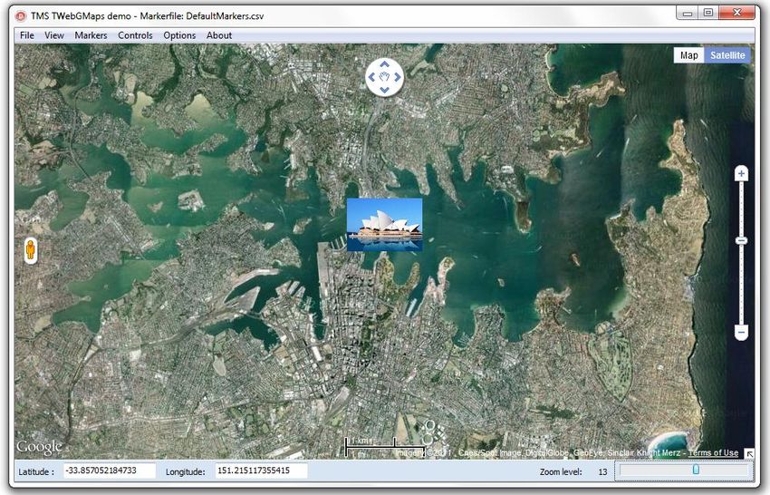
- mtSatellite:
Below is an example of a satellite map type.
The local image used for the marker was defined with the URL:
file://filepath/Sidney opera house.png.
15TMS SOFTWARE
TMS VCL WebGMaps
DEVELOPERS GUIDE
- mtHybrid:
This example shows the mix of a satellite view with added roadmap information.
The position of the Google Controls has been changed : PanControl to the TopRight position,
ZoomControl to LeftBottom and StreetviewControl to RightCenter.
16TMS SOFTWARE
TMS VCL WebGMaps
DEVELOPERS GUIDE
- mtTerrain:
On the screenshot below a Terrain map is shown. This type of map displays a topographic
type map, presenting terrain details.
The position of the Google Controls has been changed : PanControl to the TopLeft position,
MapTypeControl to TopRight. The ControlsStyle is changed to Android style. Note the zoom control
in the bottom left corner displayed in Android style.
17TMS SOFTWARE
TMS VCL WebGMaps
DEVELOPERS GUIDE
General map settings
TWebGMaps properties
- APIKey: Optionally specify an API Key to identify the application with the Google Maps API
- APIChannel: Optionally specify a Channel ID to identify the application with the Google Maps
Premium API. This value is ignored if an API Key value is specified
- APIClientAuthURL: Optionally specify the authenticated URL as specified on the Google
Maps Premium console. The Default URL is: http://127.0.0.1. This value is ignored if an API
Key value is specified
- APIClientID: Optionally specify a Client ID to identify the application with the Google Maps
Premium API. This value is ignored if an API Key value is specified
- APIClientSecret: Optionally specify a Client Secret to identify the application with the Google
Maps Premium API. If this value is specified the APISignature value is ignored and the
signature is generated automatically based on the Client ID and Client Secret value (Only
supported for the GetDirections and GetElevation calls). This value is ignored if a Signature or
API Key is specified
- APISignature: Optionally specify an API Signature to identify the application with the Google
Maps Premium API.
- AutoLaunch: Specify if the Map is displayed automatically or if a Launch call is required.
- CurrentLocation: Contains the current latitude and longitude based on the IP address after
calling GetCurrentLocation.
Note: A valid API Key from www.ipstack.com is required for this function.
The API Key must be assigned to the LocationAPIKey property
- LocationAPIKey: A valid API Key from www.ipstack.com is required for the
GetCurrentLocation function.
The API Key must be assigned to the LocationAPIKey property
- ShowDebugConsole: Optionally display a debugging console at run-time.
- PolygonLabel: Configure the appearance of the Polygon/Polyline hints. (If a value is assigned
to the TagString property of a Polygon or Polyline, this will be displayed as a hint when the
Polygon or Polyline is hovered and PolygonLabel.Visible is set to True)
o Color: Set the color of the label
o BorderColor: Set the border color of the label
o Font: Set the font of the label text (Only the Color, Name and Size are supported)
18TMS SOFTWARE
TMS VCL WebGMaps
DEVELOPERS GUIDE
o OffsetTop: Set the vertical offset of the label in pixels
o OffsetLeft: Set the horizontal offset of the label in pixels
o Margin: Set the margin of the between the label text and the label border
o Visible: Indicates if the label is displayed or not (A non-empty Polygon/Polyline
TagString property value is required to display the label)
TWebGMaps.MapOptions properties
- DefaultLatitude: Sets the latitude value for the default position when Launch is called.
- DefaultLongitude: Sets the longitude value for the default position when Launch is called.
- DefaultToCurrentLocation: Sets the current location as the default position when Launch is
called. DefaultLatitude and DefaultLongitude are ignored if set to true.
Note: A valid API Key from www.ipstack.com is required for this function.
The API Key must be assigned to the LocationAPIKey property
- DisableControls: Disables all map controls.
- DisableDoubleClickZoom: When set to true, disables zoom functions when double-clicking.
- DisablePOI: When set to true, disable display of the points of interest on the map.
- DisableTilt: Disable the auto-tilted view on satellite maptype.
Note: tilted view is only available at specific locations for specific zoom levels, this is a
limitation of the Google Maps API.
- Draggable: When set to true, the entire map can be moved around in the control.
- EnableKeyboard: When set to true, enables the use of the keyboard for controlling panning
in the map (or in street view mode).
- Language: Defines the language of the Copyright message, and the
TWebGMaps.ControlsOptions.MapTypeControl displayed text.
- MapType: Sets the type of map. Following values are defined:
mtDefault: A roadmap is displayed.
mtSatellite: A satellite view map is displayed.
mtHybrid: A satellite view map is displayed, along with roadmap information.
mtTerrain: A topographic map is displayed.
- PreloaderVisible: When set to true, an animation while loading the map is displayed.
- ShowCloud: Please note that this service is unfortunately no longer available in the Google
Maps API. When true, shows a cloud layer on top of the map
19TMS SOFTWARE
TMS VCL WebGMaps
DEVELOPERS GUIDE
- ScrollWheel: When set to true, enables the use of the scroll wheel. The scroll wheel can be
used to zoom in and out on the map.
- ShowBicycle: When set to true, and if available in your country, bicycle trail information can
be displayed on the map.
- ShowPanoramio: Please note that this service is unfortunately no longer available in the
Google Maps API. When set to true, the Panoramio functionality is activated, showing
thumbnails of posted pictures. The pictures are loaded when the thumbnail is clicked.
20TMS SOFTWARE
TMS VCL WebGMaps
DEVELOPERS GUIDE
- ShowTraffic: When set to true, and if available in your country, traffic information can be
displayed. Check for availability on:
https://spreadsheets.google.com/spreadsheet/pub?key=0Ah0xU81penP1cDlwZHdzYWkyaER
Nc0xrWHNvTTA1S1E&gid=0 .
- ShowWeather: Please note that this service is unfortunately no longer available in the
Google Maps API. when true, shows the weather conditions & option to click to show
weather forecast on the map.
21TMS SOFTWARE
TMS VCL WebGMaps
DEVELOPERS GUIDE
- ZoomMap: Is to be used to set the default zoom at startup. The zoom value is a value
between 1 and 21 with 21 being the highest zoom level.
- ZoomMarker: Sets the zoom behavior of a marker icon. When set to zmNone there is no
zooming. When set to zmToggle the marker icon is zoomed in when clicked and zoomed out
when clicked again or when a click occurs outside the marker icon. When set to zmClick the
marker icon is zoomed in when clicked and zoomed out when clicked again. To be used in
combination with the Marker’s Width, Height, ZoomWidth, ZoomHeight properties.
TWebGMaps.StreetViewOptions properties
- DefaultLatitude: Sets the latitude value for the default street view position when StreetView
is launched.
- DefaultLongitude: Sets the longitude value for the default street view position when
StreetView is launched.
- Heading: Defines the heading at the street view position. Valid values are between 0 and 360
degrees.
- Pitch: Defines the pitch (view angle) for the street view. Valid values are between -90 and 90
degrees.
- Visible: When set to true, the street view is displayed.
22TMS SOFTWARE
TMS VCL WebGMaps
DEVELOPERS GUIDE
- Zoom: Sets the zoom factor for the street view. Valid values are between 0 and 5.
TWebGMaps.WeatherViewOptions properties
- LabelColor: Sets the background color of the weather info balloons as either white or black.
- ShowInfoWindows: Enables to show balloons with weather info/forecast when clicked.
- TemperatureUnit: Sets the unit of temperature to Celcius or Fahrenheit.
- WindspeedUnit: Sets the unit of wind speed to kilomters per hour or miles per hour or
metres per second.
23TMS SOFTWARE
TMS VCL WebGMaps
DEVELOPERS GUIDE
Map markers
TMarkers is a collection of marker items giving the possibility to highlight certain locations on the
map. A marker is either a default balloon or can be set to a custom icon by defining the URL for it.
The example below shows a mix of pictures and a standard Google balloon marker. A sample on how
to create a marker info window can be found in the samples paragraph.
On the left hand side, a PNG image is used as marker. In the middle section, two JPEG images are
displayed as marker. On the right hand side, a standard Google Maps balloon marker is used, as the
marker was created with an empty icon property.
Adding markers
First open the markers collection editor by clicking the TWebGMaps.Markers property in the Object
Inspector. From here, markers can be added or removed.
24TMS SOFTWARE
TMS VCL WebGMaps
DEVELOPERS GUIDE
The equivalent in code is:
Adding a marker:
var
begin
WebGMaps1.Markers.Add(aLatitude, aLongitude, aMarkerTitle, anIcon,
aDraggable, aVisible, aClickable, aFlat, anInitialDropAnimation);
end;
TWebGMaps.Markers properties
- Clickable: When set to true, enables clicking on the marker. Clicking opens an extra info
window on the Google Maps containing the text set by Marker.Title.
- Cluster: TMapCluster: Assign a TMapCluster object to this property to link the marker to a
Cluster in the Clusters collection.
- Data: Store extra data associated with the marker.
- Draggable: When set to true, the marker can be moved around the map when dragged.
- Flat: When set to true, the marker is drawn as a flat image on the map. Otherwise the
marker is drawn as a 3D image with a shadow.
- Icon: Allows the use of an image as a marker. A local path to an image file or an url to a
remote image file are both allowed. An example can be found in the samples paragraph.
25TMS SOFTWARE
TMS VCL WebGMaps
DEVELOPERS GUIDE
- IconColor: Allows changing the color of the default marker icon to one of the available pre-
defined colors: icDefault, icBlue, icGreen, icRed and icPurple (Only available if the Icon
property is not assigned).
- IconHeight: Specify a custom height value in pixels for the marker icon when the IconState is
msDefault. Can only be used when the Icon property is assigned. If this value is not specified
the icon is displayed in its full size. Set the icon zoom behavior with the
MapOptions.ZoomMarker property.
- IconState: Sets the state of the marker icon to zoomed in or zoomed out. Should be used in
combination with IconWidth, IconHeight and IconZoomWidth, IconZoomHeight.
- IconWidth: Specify a custom width value in pixels for the marker icon when the IconState is
msDefault. Can only be used when the Icon property is assigned. If this value is not specified
the icon is displayed in its full size. Set the icon zoom behavior with the
MapOptions.ZoomMarker property.
- IconZoomHeight: Specify a custom height value in pixels for the marker icon when the
IconState is msZoomedIn. Can only be used when the Icon property is assigned. If this value
is not specified the icon is displayed in its full size. Set the icon zoom behavior with the
MapOptions.ZoomMarker property.
- IconZoomWidth: Specify a custom width value in pixels for the marker icon when the
IconState is msZoomedIn. Can only be used when the Icon property is assigned. If this value
is not specified the icon is displayed in its full size. Set the icon zoom behavior with the
MapOptions.ZoomMarker property.
- InitialDropAnimation: When set to True, the marker is dropped with an animation effect on
the map when displayed.
- Latitude: Sets the latitude value of the marker on the map.
- Longitude: Sets the longitude value of the marker on the map.
- MapLabel: Allows the use of a HTML label displayed on top of the marker. The label is
automatically resized based on the Text value. A sample on how to create a custom label for
a marker can be found in the samples paragraph.
o BorderColor: The border color of the label.
o Color: The color of the label.
o Font.Name: The font name for the label text.
o Font.Size: The font size for the label text.
o Font.Color: The font color for the label text.
o Margin: The margin in pixels between the label border and the label text.
26TMS SOFTWARE
TMS VCL WebGMaps
DEVELOPERS GUIDE
o Text: The text displayed in the label. If this value is empty, no label is displayed.
o OffsetLeft: The left offset of the label relative to the marker coordinates.
This is a percentage value. For example the value 0 will center align the label, the
value 50 will right align the label.
o OffsetTop: The top offset of the label relative to the marker coordinates.
This is a pixel value. With a default Font.Size and the default Marker the label is
displayed on top of the Marker.
SubMarkers: A collection of SubMarkers for this marker.
Submarkers are displayed in a circle around the marker connected with a line. This can be useful if
multiple markers share the same location or multiple markers are near the same location.
A click on the marker will toggle the visibility of the available submarkers. A click anywhere else on
the map will hide the submarkers.
Submarkers can also be toggled programmatically with the CreateMapSubMarkers and the
DeleteMapSubMarkers methods.
Submarkers can only be displayed for one marker at a time.
A click on a submarker will trigger the OnSubMarkerClick event.
Example to add a SubMarker to a Marker:
- var
m: TMarker;
sm: TSubMarker;
begin
m := WebGMaps1.Markers.Add(Latitude, Longitude);
m.Title := 'Parent Marker Title';
sm := m.SubMarkers.Add;
sm.Title := 'Sub Marker Title';
end;
27TMS SOFTWARE
TMS VCL WebGMaps
DEVELOPERS GUIDE
o Clickable: When set to true enables clicking on the submarker.
o Data: Store extra data associated with the submarker.
o Icon: Allows the use of an image as a marker. A local path to an image file or an url
to a remote image file are both allowed.
o IconColor: Allows changing the color of the default marker icon to one of the
available pre-defined colors: icDefault, icBlue, icGreen, icRed and icPurple (Only
available if the Icon property is not assigned).
o Title: Sets the title for the marker. This marker title will be displayed in the hint when
hovering over the marker.
o Visible: When set to true, the submarker is shown on the map if the submarkers are
visible.
o LineColor: Sets the color of the line that connects the submarker with the marker.
o LineWidth: Sets the width of the line that connects the submarker with the marker.
o LineOpacity: Sets the opacity of the line that connects the submarker with the
marker.
o Radius: Sets the distance of the submarker from the marker in pixels.
- Title: Sets the title for the marker. This marker title will be displayed in the hint, when
hovering over the marker and in the info window when the marker is clicked.
28TMS SOFTWARE
TMS VCL WebGMaps
DEVELOPERS GUIDE
- Text: Sets the character that is displayed inside the marker instead of the default “dot”.
Note: when using the default marker this is only supported when the IconColor property is
set to icDefault.
- Visible: When set to true, the marker is shown on the map.
TWebGMaps.Markers methods
- LoadFromPOI: Load markers from POI data in a file.
- LoadfromPOIStream: Load markers from POI data in a stream.
- SaveToPOI: Save markers to POI data in a file.
- SaveToPOIStream: Save markers to POI data in a stream.
POI data compatible with the data format from among others: Garmin, Tomtom, Navman, Route66,
Becker.
Map clusters
TClusters is a collection of Cluster items to create and manage per-zoom-level clusters for large
amounts of markers.
29TMS SOFTWARE
TMS VCL WebGMaps
DEVELOPERS GUIDE
Adding clusters
First open the clusters collection editor by clicking the TWebGMaps.Clusters property in the Object
Inspector. From here, clusters can be added or removed.
30TMS SOFTWARE
TMS VCL WebGMaps
DEVELOPERS GUIDE
The equivalent in code is:
Adding a cluster:
var
begin
WebGMaps1.Clusters.Add()
end;
Assigning markers to a cluster and display the cluster on the map:
var
m: TMarker;
begin
m := WebGMaps1.Markers.Add(Latitude, Longitude, 'Title');
m.Cluster := WebGMaps1.Clusters[0].Cluster;
WebGMaps1.CreateMapCluster(WebGMaps1.Clusters[0].Cluster);
Adding a marker to an existing cluster:
var
m: TMarker;
begin
m := WebGMaps1.Markers.Add(Latitude, Longitude, 'Title');
m.Cluster := WebGMaps1.Clusters[0].Cluster;
WebGMaps1.AddMarkerToCluster(WebGMaps1.Clusters[0].Cluster, m);
Removing a marker from an existing cluster:
m := WebGMaps1.Markers[WebGMaps1.Markers.Count - 1];
m.Cluster := nil;
WebGMaps1.DeleteMarkerFromCluster(WebGMaps1.Clusters[1].Cluster,
m);
Updating an existing cluster:
31TMS SOFTWARE
TMS VCL WebGMaps
DEVELOPERS GUIDE
var
c: TMapCluster;
begin
c := WebGMaps1.Clusters[0].Cluster;
c.Title := 'New Title';
c.ZoomOnClick := not c.ZoomOnClick;
WebGMaps1.UpdateMapCluster(c);
Remove a single cluster or all clusters from the map:
WebGMaps1.DeleteMapCluster(0);
WebGMaps1.DeleteAllMapCluster;
Notes:
- Removing a cluster from the map will also remove all markers assigned to that cluster from
the map.
- The clusters and markers are removed from the map, but not from the Clusters and Markers
collection of the control.
- The calls to add/update/delete a cluster can only be used after the OnDownloadFinish event
was triggered.
TWebGMaps.Clusters properties
- AverageCenter: (Boolean) Indicates if the position of a cluster marker should be the
average position of all markers in the cluster. If set to false, the cluster marker is
positioned at the location of the first marker added to the cluster.
- BatchSize: (Integer) The number of markers to be processed in a single batch.
- Calculator: (TStringList) The JavaScript function used to determine the text to be displayed
on a cluster marker and the index indicating which style to use for the cluster marker. By
default the number of markers contained in the cluster is displayed on the cluster marker.
Cluster markers containing 2-9 markers use the first style, 10-99 markers use the second
style and +100 markers use the third style. Custom styles can be configured in the Styles
collection.
The standard JavaScript function:
function(markers, numStyles) {
var index = 0;
var title = "";
32TMS SOFTWARE
TMS VCL WebGMaps
DEVELOPERS GUIDE
var count = markers.length;
var dv = count;
while (dv !== 0) {
dv = parseInt(dv / 10, 10);
index++;
}
index = Math.min(index, numStyles);
return {
text: count,
index: index,
title: title
};
};
- ClusterClass: (string) The name of the CSS class defining general styles for the cluster
markers. Use this class to define CSS styles that are not available in the TClusterStyle
properties. The CSS class code can be added using the OnInitHTML event.
Example:
procedure TForm7.WebGMaps1InitHTML(Sender: TObject; var HTML: string);
begin
HTML := HTML + '.cluster{background-color:gray;}'
end;
- GridSize: (Integer) The grid size of a cluster in pixels.
- IgnoreHidden: (Boolean) Indicates if hidden markers (Visible := False) are ignored.
- MaxZoom: (Integer) The maximum map zoom level at which clustering is enabled.
- MinimumClusterSize: (Integer) The minimum number of markers required in a cluster
before the markers are hidden and a cluster marker appears.
- Styles: (TClusterStyles)
Cluster markers containing 2-9 markers use the first style, 10-99 markers use the second
style and 100 or more markers use the third style. Different criteria can be configured by
adding a custom JavaScript function to the Calculator property.
o BackgroundPositionX (Integer) The left position of the cluster icon image defined
in the IconURL property. This property should be used if the image is a sprite that
contains multiple images.
o BackgroundPositionY (Integer) The top position of the cluster icon image defined in
the IconURL property. This property should be used if the image is a sprite that
contains multiple images.
o Font (TFont) The font used for the cluster marker text.
o IconHeight (Integer) The height of the cluster marker image.
33TMS SOFTWARE
TMS VCL WebGMaps
DEVELOPERS GUIDE
o IconOffsetX (Integer) The left position offset of the cluster marker icon relative to
the cluster location.
o IconOffsetY (Integer) The top position offset of the cluster marker icon relative to
the cluster location.
o IconURL (string) The URL of the icon image.
o IconWidth (Integer) The width of the cluster marker image.
o TextOffsetX (Integer) The left position offset of the cluster marker text relative to
the cluster location.
o TextOffsetY (Integer) The top position offset of the cluster marker text relative to
the cluster location.
Note: The IconURL, IconHeight and IconWidth properties are required when adding
a style. Style items that have an empty value for IconURL or a 0 value for
IconHeight/IconWidth will not function.
- Title: (String) The tooltip text to display for the cluster marker.
- ZoomOnClick (Boolean) Indicates if the map is zoomed to the bounds of the markers when
a cluster marker is clicked.
TWebGMaps.Clusters methods
- FitMapToMarkers(): Boolean;
Fits the map to the bounds of the markers managed by the cluster.
Map directions
TDirections is a collection of routes based on a start location and destination.
Retrieving directions
WebGMaps1.GetDirections(aOrigin, aDestination, aAlternatives, aTravelMode,
aUnits, aLanguage, aAvoidHighways, aAvoidTolls, aWaypoints,
aOptimizeWaypoints);
The Directions collection will automatically be filled with all available routes for the given
parameters.
- aOrigin: (String) The start location.
- aDestination: (String) The destination location.
34TMS SOFTWARE
TMS VCL WebGMaps
DEVELOPERS GUIDE
- aAlternatives: (Boolean) When set to true all available routes will be added to the Directions
collection. When set to false only the default route will be added to the Directions collection.
- aTravelMode: (TTravelMode) Sets which travel mode should be used to calculate the
directions.
o tmBicycling
o tmDriving
o tmWalking
- aUnits: (TUnits) Sets which unit system to use for the DistanceText values.
o usMetric: DistanceText values are returned using kilometers and meters.
o usImperial: DistanceText values are returned using miles and feet.
- aLanguage: (TLanguageName) Sets the language to use for the
Directions[].Legs[].Steps[].Instructions text values.
- aAvoidHighways: Restrict results to routes without highways
- aAvoidTolls: Restrict results to routes without tolls
- aWayPoints: List of additional locations. Waypoints allow you to calculate routes through
additional locations, in which case the returned route passes through the given waypoints.
- aOptimizeWaypoints: Allow the Directions service to optimize the provided route by
rearranging the waypoints in a more efficient order
TWebGMaps.Directions properties
- Bounds: Sets the bounds of a route.
o NorthEast: Sets the latitude/longitude of the north east corner of the route.
Latitude
Longitude
o SouthWest: Sets the latitude/longitude of the south west corner of the route.
Latitude
35TMS SOFTWARE
TMS VCL WebGMaps
DEVELOPERS GUIDE
Longitude
- Copyrights: (readonly) Copyrights text to be displayed for this route.
- Legs: Contains information about this route and the steps of which it is composed.
o Distance: The total distance of the leg in meters.
o DistanceText: The text value of the total distance of the leg. If the usMetric
parameter value is used in the GetDirections call then this value is specified in
kilometers/meters. If the usImperial parameter value is used, the value is specified in
miles/feet.
o Duration: The typical required time for this leg in seconds.
o DurationText: The typical required time for this leg specified in hours/minutes.
o EndAddress: The address of the destination of this leg.
o EndLocation: The geocoded destination of this leg.
Latitude
Longitude
o StartAddress: The address of the origin of this leg.
o StartLocation: The geocoded origin of this leg.
Latitude
Longitude
o Steps:
Distance: The distance covered by this step in meters.
DistanceText: The text value of the distance covered by this step. If the
usMetric parameter value is used in the GetDirections call then this value is
specified in kilometers/meters. If the usImperial parameter value is used, the
value is specified in miles/feet.
Duration: The typical required time to perform this step in seconds.
DurationText: The typical required time to perform this step specified in
hours/minutes.
EndLocation: The ending location of this step.
Latitude
36TMS SOFTWARE
TMS VCL WebGMaps
DEVELOPERS GUIDE
Longitude
Instructions: Instructions text for this step.
Polyline: A polyline describing the course for this step.
See Map Polylines for details.
StartLocation: The starting location of this step.
Latitude
Longitude
TravelMode: The mode of travel used in this step.
tmBicycling
tmDriving
tmWalking
WayPointIndex: Contains the index of the item in the list of WayPoints
provided with the GetDirections call that corresponds with this Leg
- Polyline: A polyline that represents the entire course of this route. The path is simplified in
order to make it suitable in contexts where a small number of vertices is required.
o See Map Polylines for details.
- Summary: Descriptive text for this route.
- TotalDistance: The total distance covered by this route in meters.
- TotalDuration: The typical required time to perform this step in seconds.
37TMS SOFTWARE
TMS VCL WebGMaps
DEVELOPERS GUIDE
Map polygons
WebGMaps.Polygons is a collection of closed lines giving the possibility to highlight certain regions
on the map. The screenshot below shows a circle around Paris.
Adding polygons
First open the polygons collection editor by clicking the TWebGMaps.Polygons property in the Object
Inspector. From here, polygons can be added or removed.
38TMS SOFTWARE
TMS VCL WebGMaps
DEVELOPERS GUIDE
The equivalent in code is:
Adding a polygon:
var
PolygonItem: TPolygonItem;
begin
PolygonItem := WebGMaps1.Polygons.Add;
PolygonItem.Polygon.BackgroundOpacity := 50;
PolygonItem.Polygon.BorderWidth := 2;
//Settings for a Polygon of type Circle
PolygonItem.Polygon.PolygonType := ptCircle;
PolygonItem.Polygon.Radius := 10000;
PolygonItem.Polygon.Center.Latitude := 50;
PolygonItem.Polygon.Center.Longitude := 2;
//Settings for a Polygon of type Rectangle
PolygonItem.Polygon.PolygonType := ptRectangle;
PolygonItem.Polygon.Bounds.NorthEast.Latitude := 52;
PolygonItem.Polygon.Bounds.NorthEast.Longitude := 4;
PolygonItem.Polygon.Bounds.SouthWest.Latitude := 50;
PolygonItem.Polygon.Bounds.SouthWest.Longitude := 3;
//Settings for a Polygon of type Path
PolygonItem.Polygon.PolygonType := ptPath;
PolygonItem.Polygon.Path.Add(50, 2);
PolygonItem.Polygon.Path.Add(52, 4);
PolygonItem.Polygon.Path.Add(50, 4);
WebGMaps1.CreateMapPolygon(PolygonItem.Polygon);
end;
39TMS SOFTWARE
TMS VCL WebGMaps
DEVELOPERS GUIDE
Editing a polygon:
PolygonItem.Polygon.Visible := not PolygonItem.Polygon.Visible;
WebGMaps1.UpdateMapPolygon(PolygonItem.Polygon);
Removing a polygon:
//Removes the Polygon from the map
WebGMaps1.DeleteMapPolygon(PolygonItem.Index);
//Removes the Polygon from the collection
WebGMaps1.Polygons.Delete(PolygonItem.Index);
TWebGMaps.Polygons properties
- BackgroundColor: The color of the polygon.
- BackgroundOpacity: The opacity of the polygon.
- BorderColor: The border color of the polygon.
- BorderOpacity: The border opacity of the polygon.
- BorderWidth: The width of the polygon border in pixels.
- Bounds: Sets the bounds of a polygon when PolygonType is set to ptRectangle.
o NorthEast: Sets the latitude/longitude of the north east corner of the rectangle
Latitude
Longitude
o SouthWest: Sets the latitude/longitude of the south west corner of the rectangle
Latitude
Longitude
- Center: Sets the latitude/longitude of the center point of the circle when PolygonType is set
to ptCircle.
40TMS SOFTWARE
TMS VCL WebGMaps
DEVELOPERS GUIDE
o Latitude
o Longitude
- Clickable: When set to true, enables clicking on the polygon.
- Editable: When set to true, the polygon can be edited.
- Geodesic: When set to true, each edge is rendered as a geodesic. When set to false, render
each edge as a straight line.
- HoverBackgroundColor: The color of the polygon when hovered
- HoverBorderColor: The border color of the polygon when hovered
- Path: The ordered sequence of coordinates of the polygon that forms a closed loop (when
PolygonType is set to ptPath). Paths are closed automatically.
o Latitude: Sets the latitude value of the polygon path item on the map.
o Longitude: Sets the longitude value of the polygon path item on the map.
- PolygonType: Sets the type of polygon to be rendered.
o ptCircle: Renders a circle based on the Radius and Center property values.
o ptPath: Renders a polygon based on the list of Path coordinates.
o ptRectangle: Renders a rectangle based on the Bounds property values.
- Radius: The radius of the polygon in meters. (When PolygonType is set to ptCircle)
- TagString: The text associated with the polygon (optional). The appearance of the hint can be
configured with the PolygonLabel properties. If PolygonLabel.Visible is set to true, this value
will be displayed as a hint when hovering the polygon on the map.
- TagObject: The object associated with the polygon (optional)
- Visible: When set to true, the polygon is shown on the map.
- Zindex: The zIndex compared to other elements on the map.
41TMS SOFTWARE
TMS VCL WebGMaps
DEVELOPERS GUIDE
Map polylines
WebGMaps.Polylines is a collection of lines giving the possibility to highlight certain routes on the
map. The screenshot below shows a route between a start and end location.
Adding polylines
First open the polylines collection editor by clicking the TWebGMaps.Polylines property in the Object
Inspector. From here, polylines can be added or removed.
42TMS SOFTWARE
TMS VCL WebGMaps
DEVELOPERS GUIDE
The equivalent in code is:
Adding a polyline:
var
PolylineItem: TPolylineItem;
begin
PolylineItem := WebGMaps1.Polylines.Add;
PolylineItem.Polyline.Width := 2;
PolylineItem.Polyline.Path.Add(50, 2);
PolylineItem.Polyline.Path.Add(52, 4);
PolylineItem.Polyline.Path.Add(50, 4);
WebGMaps1.CreateMapPolyline(PolylineItem.Polyline);
end;
Editing a polyline:
PolylineItem.Polyline.Visible := not PolylineItem.Polyline.Visible;
WebGMaps1.UpdateMapPolyline(PolylineItem.Polyline);
Removing a polyline:
//Removes the Polyline from the map
WebGMaps1.DeleteMapPolyline(PolylineItem.Index);
//Removes the Polyline from the collection
WebGMaps1.Polylines.Delete(PolylineItem.Index);
43TMS SOFTWARE
TMS VCL WebGMaps
DEVELOPERS GUIDE
TWebGMaps.Polylines properties
- Clickable: When set to true, enables clicking on the polyline.
- Color: The color of the polyline.
- Editable: When set to true, the polyline can be edited.
- Geodesic: When set to true, each edge is rendered as a geodesic. When set to false, render
each edge as a straight line.
- HoverColor: The color of the polyline when hovered.
- Icons: The list of icons to be rendered along the polyline.
o SymbolType: The type of icon that is displayed on the polyline.
o Offset: The distance from the start of the line at which an icon is to be rendered. Can
be set as a percentage (OffsetType set to dtPixels) or in pixels (OffsetType set to
dtPercentage).
o OffsetType: Defines the way the Offset value is used.
ctPercentate: The Offset is handled as a percentage value.
ctPixel: The Offset is handled as a pixel value.
o RepeatValue: The distance between consecutive icons on the line. Can be set as a
percentage (RepeatType set to dtPixels) or in pixels (RepeatType set to
dtPercentage).
o RepeatType:
ctPercentate: The RepeatValue is handled as a percentage value.
ctPixel: The RepeatValue is handled as a pixel value.
o FixedRotation: If set to true, each icon in the sequence has the same fixed rotation
regardless of the angle of the edge on which it lies. If set to false, each icon in the
sequence is rotated to align with its edge.
- Opacity: The opacity of the polyline.
- Path: The ordered sequence of coordinates of the polyline.
o Latitude: Sets the latitude value of the polyline path item on the map.
o Longitude: Sets the longitude value of the polyline path item on the map.
44TMS SOFTWARE
TMS VCL WebGMaps
DEVELOPERS GUIDE
- TagString: The text associated with the polyline (optional). The appearance of the hint can be
configured with the PolygonLabel properties. If PolygonLabel.Visible is set to true, this value
will be displayed as hint when hovering the polyline on the map.
- TagObject: The object associated with the polyline (optional)
- Visible: When set to true, the polyline is shown on the map.
- Width: The width of the polyline in pixels.
- Zindex: The zIndex compared to other elements on the map.
45TMS SOFTWARE
TMS VCL WebGMaps
DEVELOPERS GUIDE
Map ControlsOptions
The ControlsOptions class property bundles various settings for controlling the appearance and
behaviour of various controls in the map.
TWebGMaps.ControlsOptions properties
- ControlsType: Sets the control to one of the defined types: ctAndroid, ctDefault, ctSmall or
ctZomPan.
o ctAndroid: Changes the zoom control to Android style.
o ctDefault: Sets all controls to Google style controls. Please check ZoomControl zsLarge
for an image.
o ctSmall: Sets the zoom control to a small format control. Please check ZoomControl
zsSmall for an image.
o ctZoomPan: Sets the zoom control to the standard Google Maps zoom control.
- MapTypeControl: Defines the settings for the MapType control that allows choosing another
map view from within the actual map.
46TMS SOFTWARE
TMS VCL WebGMaps
DEVELOPERS GUIDE
o Position: Sets the TWebGMaps.ControlsOptions.MapTypeControl.Position to one of
these predefined choices: cpBottomLeft, cpBottomCenter, cpBottomRight,
cpLeftBottom, cpLeftCenter, cpLeftTop, cpRightBottom, cpRightCenter, cpRightTop,
cpTopCenter, CpTopLeft, cpTopRight.
o Style: Sets the TWebGMaps.ControlsOptions.MapTypeControl.Style to one of these
predefined choices: mtsDefault, mtsDropDownMenu or mtsHorizontalBar.
mtsDefault: For more info, check mtsHorizontalBar.
mtsDropDownMenu: Displays the maptype control as a drop down menu. When
choosing Map, the possibility is offered to draw the map in Terrain mode. When
Satellite is chosen, the possibility is offered to show map details (Hybrid mode).
mtsHorizontalBar: Displays the maptype control as a horizontal bar. When Map is
clicked, the possibility is offered to draw the map in Terrain mode. When Satellite is
chosen, the possibility is offered to show map details (Hybrid mode).
o Visible: When set to true, the MapType control is drawn on the map.
- OverviewMapControl: Defines the settings for the overview map control that shows a larger
area, with the actual view displayed in transparent blue. When holding the mouse down in
this blue area, and moving within the overviewmap control, the map can be panned to
another location.
o Open: When set to true, the overview map is shown is displayed in the right bottom
corner of the map. When set to false, an arrow control is drawn that opens the
overview map control when clicked.
o Visible: When set to true, the OverviewMap control is drawn on the map.
- PanControl: Sets the pan control that allows panning the actual view of the map within the
control, by clicking the arrow keys (up, down, left, right).
47TMS SOFTWARE
TMS VCL WebGMaps
DEVELOPERS GUIDE
o Position: Sets the TWebGMaps.ControlsOptions.PanControl.Position to one of these
predefined choices: cpBottomLeft, cpBottomCenter, cpBottomRight, cpLeftBottom,
cpLeftCenter, cpLeftTop, cpRightBottom, cpRightCenter, cpRightTop, cpTopCenter,
CpTopLeft, cpTopRight.
o Visible: When set to true, the Pan control is drawn on the map.
- RotateControl: Sets the rotate control that allows rotating the map and switching between
tilted and default view on satellite map type.
Note: Only available on satellite map type for specific locations and specific zoom levels.
o Position: Sets the TWebGMaps.ControlsOptions.RotateControl.Position to one of
these predefined choices: cpBottomLeft, cpBottomCenter, cpBottomRight,
cpLeftBottom, cpLeftCenter, cpLeftTop, cpRightBottom, cpRightCenter, cpRightTop,
cpTopCenter, CpTopLeft, cpTopRight.
o Visible: When set to true, the Rotate control is drawn on the map.
Note: the control can only be visible on satellite map type for specific locations and
specific zoom levels.
- ScaleControl: Defines the settings for the Scale control that shows the actual scale of the
view in the control. When the Google logo is clicked, the actual view is opened in Google
Maps in a web browser page.
48You can also read