River Murray Flow Report and Water Resources Update - WaterConnect
←
→
Page content transcription
If your browser does not render page correctly, please read the page content below
River Murray Flow Report and
Water Resources Update

Report #12/2020
Issued 10:00 am 20 March 2020
This supersedes the previous flow report issued by the Department for Environment and Water (DEW) on 13 March
2020. The next flow report will be provided on Friday 27 March 2020.
In this report, for ease of representation, large volumes of water are expressed in gigalitres (GL), while smaller volumes are
expressed in megalitres (ML). One GL is equal to 1 000 ML.

WATER ALLOCATIONS
Water allocations for South Australian River Murray Class 3 water access entitlement holders are 100%.
For more information on South Australia’s water allocations visit the DEW website or email
DEWRiverMurrayOps@sa.gov.au
For information on Victoria’s water allocations visit Victorian Water Allocations
For information on NSW water allocations visit NSW Water Allocation Statements.

EARLY INFORMATION FOR 2020-21 WATER USE YEAR
In preparation for the 2020-21 water use year, regular updates with early information will continue to be provided ahead
of the projected opening minimum water allocation announcement on 15 April 2020.

In response to the Department of Health’s recommended limits on organised gatherings, the Department for Environment
and Water (DEW) is not proposing to conduct a round of public information sessions on this year’s water allocation
announcement and processes. However, DEW is considering other options to provide information to affected
stakeholders. Keep an eye on the Department for Environment and Water website for the latest information.

RM WATER USERS REMINDED OF REQUIREMENT TO REMAIN WITHIN ALLOCATIONS
Water users along South Australia’s River Murray are reminded of the requirement to ensure that they have not used more
water than their available water allocation and to submit meter readings to the Department for Environment and Water
(DEW) at the end of each quarter.
Since 2019, penalties apply if water users exceed the volume of water available on their account (their water allocation) at
the end of each quarter. This is to help ensure that water can be reliably delivered to all River Murray water users in South
Australia and to protect the passage of environmental water through the river system.
Water users are encouraged to closely monitor their water use throughout the year and remain within their water allocations.
Water users can submit an online meter reading at any time and elect to receive a water usage advice statement (similar to
a bank statement) by email or SMS. This helps ensure they are monitoring water use and remaining within their available
water allocation.
The majority of South Australia’s River Murray water users do the right thing and remain within their available allocation.
This change does not affect those water users who operate within the terms of their water account and ensure a credit
balance at the end of each quarter.
The end of Quarter 3 of the 2019-20 water use year is 31 March 2020. A penalty will be applied in all instances where the
volume of water taken for Quarter 3 is in excess of the available allocation on a water account after 5:00 pm on 31 March
2020.
It is important to note that in order for a water trade to be considered for Quarter 3 of the 2019-20 water use year, the
application must be submitted to DEW before 5:00 pm on 31 March 2020.
For more information or to access the online meter reading form, please see the DEW website or contact the Berri water
licencing office via telephone: (08) 8595 2053 or via email: DEWwaterlicensingberri@sa.gov.au.
RAINFALL EVENTS
Recent heavy rainfall events have generated inflows in most river systems across the Northern Basin (Barwon-Darling
system). On 10 March 2020, the Darling River started to flow into Menindee Lakes (Lake Wetherell). On 18 March 2020,
Water NSW advised that the total forecast volume expected to reach Menindee Lakes has increased to around 275 to
340 GL. The projected volume will be updated as changes are observed. For the latest information on inflows please visit
https://www.waternsw.com.au/about/newsroom
WATER RESOURCES UPDATE
During February 2020, the total River Murray System inflow was approximately 67 GL, which is approximately 35% of the
February long-term average of 189 GL. There was no inflow to Menindee Lakes (from the Darling System) during February
2020, compared to the February long-term average of 124 GL.
The flow to South Australia during February 2020 was approximately 218 GL, which is about 75% of the February long-term
average of approximately 291 GL. The flow comprised of Entitlement Flow (including environmental water on SA licence),
environmental water and trades.
MANAGEMENT OF SOUTH AUSTRALIA’S DEFERRED WATER
The Murray-Darling Basin Authority confirmed that on 1 March 2020 South Australia had 339.3 GL of deferred water held in
storage in the Murray-Darling Basin. The table below identifies the storage in which it is held and the purpose. Volumes
stored are adjusted for net evaporation losses and spills until delivered to South Australia.
At 1 March 2020
Purpose Lake Victoria Hume Dartmouth Total
(GL) (GL) (GL) (GL)
*CHWN 0.0 0.0 237.9 237.9
Private Carryover 0.0 0.0 101.4 101.4
Total 0.0 0.0 339.3 339.3
*Critical Human Water Needs (CHWN)
RAINFALL AND TEMPERATURE OUTLOOK
The latest Bureau of Meteorology weather outlook for the Murray-Darling Basin from April to June 2020 indicates that the
region is expected to receive:
above average to average, rainfall; and
above average to average temperatures.
Major climate drivers including the Indian Ocean Dipole and El Niño-Southern Oscillation are currently neutral and
expected to remain neutral until mid-year. When these drivers are neutral, other influences can affect the Australian
climate. Warmer waters surrounding northern Australia are likely, which would typically increase the chance of wetter
conditions in southern Australia. All climate drivers will be tracked closely over the coming season.
The latest Bureau of Meteorology outlook information can be accessed here.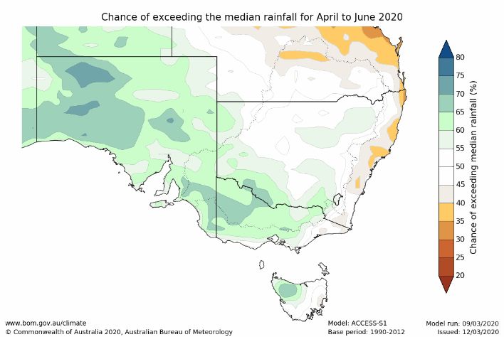
STORAGE VOLUMES
Murray-Darling Basin Storage Volumes
Storage Full Supply Volume 18/3/2020 18/3/2019 Long-term
average
(end of March)
(GL) (GL) (GL) (GL)
Dartmouth 3 856 1 803 (47%) 2 441 (63%)
Hume 3 003 481 (16%) 691 (23%)
Lake Victoria 677 256 (38%) 278 (41%)
Menindee Lakes *1 731 85 (5%) 24 (1%)
TOTAL 9 267 2 625 (28%) 3 434 (37%) 5 504 (59%)
*Menindee Lakes can be surcharged to 2 015 GL
The below graph has been provided by the Murray-Darling Basin Authority. The graph shows the volume of water held in
the Murray-Darling Basin storages from June 2000 to now and the long-term average storage for the same period.
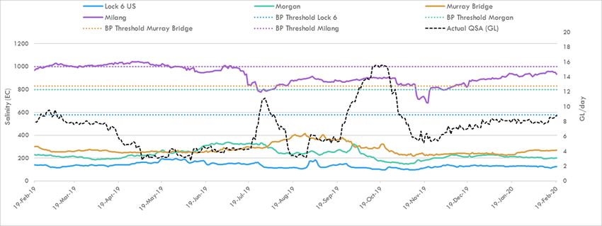
WATER QUALITY - Salinity
A number of targets are identified under the Murray-Darling Basin Plan, which all Basin jurisdictions must have regard to in
managing River Murray flows. The targets for real-time salinity are identified below. Salinity should not exceed these values
for 95% of the time:
580 EC at Lock 6
800 EC at Morgan
830 EC at Murray Bridge
1 000 EC at Milang.
The following graph shows the salinity at these locations and the flow to South Australia (QSA) from March 2019 to March
2020. The dashed-lines identify the Basin Plan (BP) thresholds for the corresponding colour coded location.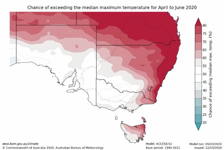
SA River Murray Daily Average Salinity
FLOW OUTLOOK
It is likely that reduced Entitlement Flow will continue during the 2019-20 water year. In addition to reduced Entitlement
Flow, South Australia will receive water for the environment.
The flow at the South Australian border is approximately 5 GL/day and will remain around this rate during the coming
week. It comprises:
reduced March Entitlement Flow (5.1 GL/day);
water for the environment (see below Water for the Environment); and
interstate trade adjustments.
The flow over Lock 1 is approximately 2.7 GL/day and will decrease to around 2.6 GL/day during the coming week,
depending on weather conditions and extractions.
It is important to note that flow forecasts in this advice are based on the information available at the time of preparation.
Advice may change as new gauging information becomes available or due to rainfall events or changed operations
upstream.
WATER FOR THE ENVIRONMENT
Water for the environment is currently being used to:
provide for barrage releases to the Coorong to support a productive, food-rich environment for fish and birds;
maintain good connections from the Coorong to the upstream areas of the River Murray, and its tributaries, to enable
fish movement and migration;
maintain water quality, salinity and water levels below critical thresholds in the River Murray channel, Lower Lakes and
Coorong;
deliver a range of outcomes to wetlands in the Riverland via arrangements with the South Australian Murray-Darling
Basin Natural Resources Management Board, Renmark Irrigation Trust, Banrock Station and the Nature Foundation
South Australia; and
deliver a range of outcomes to wetlands on the Chowilla floodplain via The Living Murray.
MURRAY MOUTH
Dredging operations at the Murray Mouth commenced on 9 January 2015 to maintain connectivity (exchange of water)
between the Coorong and the Southern Ocean. At 15 March 2020, a total of approximately 5 499 129 cubic metres of
sand had been removed by dredging operations.
Two dredges are operating between the Goolwa and Tauwitchere channels 24 hours a day, 7 days a week.
Barrage releases combined with dredging have helped to maintain connectivity of the Murray Mouth.
There are a number of shallow zones in and adjacent to the Murray Mouth. Mariners should use caution when traversing
the mouth area, follow all directions, reduce speed and avoid travelling at low tide. Mariners equipped with echo sounders
should check depths regularly. Navigation through the Murray Mouth is only permitted during daylight hours. ExclusionZones established around the dredging operations are in place to ensure public safety. Refer to Notice to Mariners
No 42 of 2016 Notice 42.
There is a partial park closure in place for the northern tip of the Coorong National Park. For more information visit
Coorong partial park closure notice.
BARRAGE OPERATIONS AND WATER LEVELS IN THE LOWER LAKES
The water level in Lake Alexandrina is approximately 0.53 m AHD and Lake Albert is approximately 0.57 m AHD. The
difference in water level is due to wind effects.
Water for the environment has enabled continuous fishway releases and small barrage releases to be undertaken during
summer and into autumn. During the past week, fishways at all the barrages have provided connectivity between the
Coorong and the Lower Lakes. In addition, Tauwitchere Barrage (1-2 gates plus fishway) has provided targeted releases
when the wind, swell and tide conditions align to push fresher water down the Coorong. As of Tuesday 17 March 2020,
the weekly releases were approximately 2.1 GL. During adverse weather conditions, SA Water will operate the barrages to
minimise the risk of seawater entering Lake Alexandrina, therefore minimising any negative salinity impacts from reverse
flow events.
Water levels and barrage operations are monitored closely by the South Australian Government, Murray-Darling Basin
Authority and Commonwealth Environmental Water Office.
LOCK 3 RIVER VESSEL WASTE DISPOSAL STATION
The Lock 3 River Vessel Waste Disposal Station is currently out of commission due to an infrastructure failure. This means
that boat operators who need to empty sewage tanks will need to use the nearest alternative waste facilities located at
Waikerie and Loxton. Alternatively boat operators who require an urgent pump-out in the Kingston-on-Murray area can
contact Mr Hayden Smith on 0457 820 553 for help or advice. Normal boat waste (domestic or galley waste) can still be
deposited at the Lock 3 facility at the present time.
NAVIGATION ISSUES
Sandbars in the vicinity of the Murray Mouth may cause navigation hazards. Mariners are advised to navigate with caution
when operating in the area. Sandbars are also present along sections of the River Murray downstream of Locks 7 and 8
and in South Australia. All Mariners should be aware of the risk of submerged navigation hazards and should regularly
check river depth.
SOUTH AUSTRALIAN RIVERLAND FLOODPLAINS INTEGRATED INFRASTRUCTURE
PROGRAM CONSTRUCTION WORKS
Katarapko
Construction works on the Katarapko Floodplain are progressing well and are expected to be completed by mid-2020.
Some parts of the Murray River National Park currently remain closed for camping and other recreational activities during
this period.
Campsites within the Lock 4, Eckerts Creek and Katarapko Creek sections of the Murray River National Park at Katarapko
are planned to be re-opened in time for Easter. Campsites are available to book now, for bookings commencing on
Wednesday 8 April 2020 on the following website https://www.parks.sa.gov.au/find-a-
park/Browse_by_region/Murray_River/murray-river-national-park. Please be aware there have been a number of changes
to roads within the Park. A map is currently being produced to assist campers navigate to their site for Easter. This will be
communicated on the Parks SA website. There will be parts of the Murray River National Park that remain closed due to
construction works that are still in progress. Please be aware of these sites and follow the appropriate signage warnings.
For safety reasons, the following water access restrictions apply to river vessels and people (other than authorised
personnel) until late March 2020:
Sawmill Creek, the entire length between Katarapko Creek and Eckert’s Creek; and
Eckert’s Creek, for 1.3 kilometres upstream of the confluence point with Katarapko Creek (ie The Splash).
Pike
Although work on the regulating structures and blocking bank on the Pike Floodplain is now complete, other works
continue in this area. Vessels and persons other than those participating in the works are still prohibited from entering the
Pike River near the Rumpagunyah Creek and Tanyaca Creek junction, downstream of the Mundic Creek junction.RIVER MURRAY WATER LEVELS
Below is a table of River Murray water levels at a number of locations from Lock 10 to Murray Bridge.
River Murray Water Levels
Location River km Normal Current 1974 1993 2016
Pool Level Flood Flood High Water
Level 18/3/2020 Level Level Level
(m AHD) (m AHD) (m AHD) (m AHD) (m AHD)
825.0 30.80 30.90 33.81 33.32 32.72
Lock 10
764.8 27.40 27.33 30.03 29.44 28.85
Lock 9 Kulnine
725.7 24.60 23.61 27.60 27.19 26.85
Lock 8 Wangumma
696.6 22.10 21.52 25.70 25.24 24.97
Lock 7 Rufus River
619.8 19.25 19.29 21.03 20.50 20.19
Lock 6 Murtho
567.4 - 16.34 18.54 18.04 17.44
Renmark
562.4 16.30 16.34 18.07 17.50 17.05
Lock 5
537.8 - 13.22 16.85 16.26 15.80
Lyrup
525.9 - 13.29 15.81 15.74 15.21
Berri
516.2 13.20 13.29 15.65 15.08 14.73
Lock 4
489.9 - 10.02 15.05 14.12 13.54
Loxton
446.9 - 9.88 13.44 12.38 11.59
Cobdogla
431.4 9.80 9.85 13.16 12.02 10.98
Lock 3
425.9 - 6.28 12.73 11.58 10.41
Overland Corner
383.6 - 6.29 11.26 10.24 9.20
Waikerie
362.1 6.10 6.18 10.28 9.30 8.32
Lock 2
332.6 - 3.38 9.17 8.08 7.01
Cadell
321.7 - 3.33 8.85 7.65 6.38
Morgan
274.2 3.20 3.28 6.81 5.38 4.46
Lock 1 Blanchetown
245.0 0.75 0.50 6.06 4.51 3.11
Swan Reach
149.8 0.75 0.54 3.15 1.90 1.33
Mannum PS
115.3 0.75 0.50 2.06 1.26 1.04
Murray Bridge
Note that the above water levels may be affected by local wind conditionsFURTHER INFORMATION The WaterConnect website is South Australia’s comprehensive water information portal. For real-time data (like salinity, water levels) go to the following page: WaterConnect Real-time water data. Up-to-date River Murray salinity, flow and water level information can be accessed at the Department for Environment and Water, SA Water and Murray-Darling Basin Authority websites: Water allocation and carryover announcements River Murray real-time water data SA Water River Murray info - levels, flows etc. Murray-Darling Basin real-time water data The latest news, information and announcements about the River Murray and Basin Plan are available at River Murray Update. The Department for Environment and Water has published a series of inundation maps for the River Murray. They are available at River Murray Inundation Maps. Information on the management of acid drainage water in the Lower River Murray can be accessed at: Acid drainage water LMRIA Details of river height and rainfall information in the River Murray within Victoria and New South Wales are available at the Bureau of Meteorology website: Victoria rainfall and river conditions NSW rainfall and river conditions Information provided by the Commonwealth Environmental Water Office can be accessed at CEWH Environmental Watering. Information on The Living Murray can be accessed at MDBA TLM. Chowilla Floodplain Icon Site management Chowilla-floodplain. Department for Environment and Water Home page. Information provided by the Department of Planning, Transport and Infrastructure on boat licences, registering motor boats, owning and operating water craft, and boat and marine safety can be accessed at Boating and marine. ID RM-Flow-Report 20200320 Classification Public I2 A2 Issued 20 March 2020 Authority DEW Master Document Location R:\Water Group\RMO\WRO\04 Communications\Flow Advices\2019-20 Managed and Maintained by Water Infrastructure and Operations Branch Author Water Infrastructure and Operations Branch Reviewer Director, Water Infrastructure and Operations
You can also read