Road Management Strategy 2020-25 Sealed Roads April 2020 - Shire of ...
←
→
Page content transcription
If your browser does not render page correctly, please read the page content below
Road Management Strategy 2020-25 Sealed Roads April 2020
Shire of Derby/West Kimberley Road Management Strategy 2020-25 – Sealed Roads April 2020

Table of Contents
1.      SECTION 1. Executive Summary................................................................................................................................... 4
SECTION 2. Introduction ...................................................................................................................................................... 5
     2.1 Background............................................................................................................................................................... 5
        2.1.1        Relationship between the Sealed Road Management Strategy and Legislation ......................................... 5
        2.1.2        Purpose ........................................................................................................................................................... 5
        2.1.3        Execution ........................................................................................................................................................ 5
        2.1.4        Key Stakeholders ............................................................................................................................................ 5
        2.1.5        Duty of road users .......................................................................................................................................... 6
        2.1.6        Budget............................................................................................................................................................. 6
SECTION 3 – Road Asset Description .................................................................................................................................... 7
        3.1      Overview ............................................................................................................................................................. 7
        3.2      Assets covered .................................................................................................................................................... 7
        3.3      Roads Maintained by the Shire .......................................................................................................................... 7
        3.4      Existing Condition of Shire Roads ...................................................................................................................... 7
4.      ROAD INFRASTRUCTURE HIERARCHY ........................................................................................................................... 8
        4.1      Road Hierarchy ................................................................................................................................................... 8
        4.2      Road Treatment by Hierarchy ............................................................................................................................ 9
        4.3      Proposed Maintenance Practices ....................................................................................................................... 9
        4.4      Town and Rural Road Treatments ..................................................................................................................... 9
5.      PERFORMANCE STANDARDS ...................................................................................................................................... 10
     5.1         Objectives .......................................................................................................................................................... 10
     5.2         Hazard and Defect Inspections .......................................................................................................................... 10
     5.3         Hazard Identification ......................................................................................................................................... 10
     5.4         Defect Intervention Level and Rectification Time ............................................................................................. 10
6       NETWORK CHALLENGES and POTENTIAL SOLUTIONS ................................................................................................ 10
7       REVIEW OF SEALED ROAD MANAGEMENT STRATEGY ............................................................................................... 11
8       DEFINITIONS ............................................................................................................................................................... 11
APPENDIX 1- FIVE YEAR FUNDING PROGRAMME ............................................................................................................... 13
APPENDIX 2 – ROAD HIERARCHY ........................................................................................................................................ 15
APPENDIX 3 – FORWARD WORKS PROGRAMME................................................................................................................ 22
APPENDIX 4 – SERVICE LEVELS ............................................................................................................................................ 25
APPENDIX 5 – DEFECT INTERVENTION LEVEL & RECTIFICATION TIME ............................................................................... 30
APPENDIX 6 – MAPS SHOWING LOCATION OF SHIRE OF DERBY/WEST KIMBERLEY SEALED ROAD NETWORK ................. 32
APPENDIX 7 – VISUAL ASSESSMENT OF ROAD PAVEMENT MANUAL ................................................................................ 39
APPENDIX 8 – HOW TO ASSESS ROAD PAVEMENT CONDITION MANUAL ......................................................................... 42
APPENDIX 9 – SAMPLE PHOTOS - SEALED ROAD CONDITIONS .......................................................................................... 46

                                                                                                                                                                          Page | 2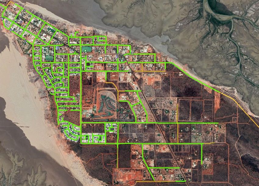
Shire of Derby/West Kimberley Road Management Strategy 2020-25 – Sealed Roads April 2020

Document Control

 Title: Sealed Road Management Strategy

 Revision   Date          Details                    Authorship    Approved
    A       Nov 2015      Draft for Review             MES / AMC         EMTDS

                          Draft reviewed after
    B       Dec 2015                                   MES / AMC         EMTDS
                          comments

                          Further review to road
    C       Sept 2018                                  MES / AMC         EMTDS
                          ranking system

     1      March 2020    Strategy for adoption by       MES              DTDS
                          Council

                                                                                   Page | 3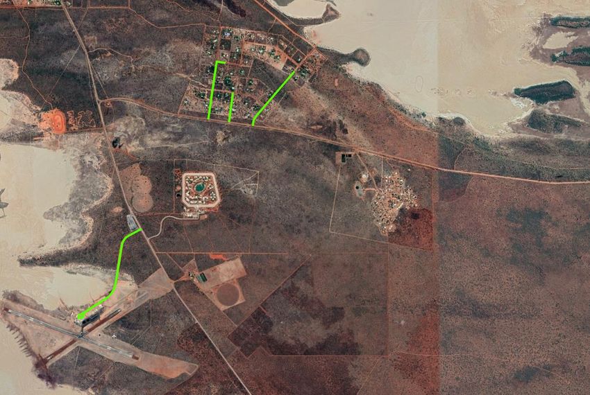
Shire of Derby/West Kimberley Road Management Strategy 2020-25 – Sealed Roads April
2020
1. SECTION 1. Executive Summary
In accordance with Item 2.3.1 of the Shire of Derby / West Kimberley Strategic Community Plan 2012-
2021 – Develop a road maintenance, grading and upgrading strategy, the Technical Services
Department has undertaken a review and critical analysis of the current maintenance practices for
our sealed roads.
The purpose of this Sealed Road Management Strategy (this Strategy) is to establish a management
system for Shire of Derby / West Kimberley (the Shire) for the discharge of its duty to inspect, maintain
and repair its public roads based on policy and operational objectives as well as available resources.
This Strategy has been prepared in accordance with the requirements of the following statutory
requirements:
Local Government Act 1995
Local Government Regulations 1996
Department of Local Government Integrated Planning and Reporting Framework
AS/ISO 55001:2014 Asset Management – Management Systems – Requirements
In accordance with the requirements of these documents, this strategy includes and references:
i. A Road Register with a description of those assets on sealed roads for which the Shire is
responsible;
ii. The standard or target service level for those assets to be maintained by the Shire; and
iii. A management system that documents how the Shire discharges its duty to inspect, maintain
and repair sealed roads for which it is responsible.
Inspection activities are undertaken at frequencies relative to the road hierarchy while the prioritisation
of maintenance and repair activities are based on an assessment of the risks associated with individual
defects.
A tolerable level of defect is defined as a condition that does not require immediate attention based on
a standardised risk assessment and future programmed works are scheduled.
In establishing its budget priorities the Council seeks to strike a balance between the need to invest in
new infrastructure for a growing community while providing levels of service consistent with
community expectations for existing assets.
Road based maintenance and rehabilitation works are coordinated by the Shire’s Technical Services
Department using a combination of internal and external labour and equipment. Detailed operational
procedures specify how the various activities are to be undertaken and the technical standards to be
achieved.
Community requests for works to be undertaken are recorded in the council’s customer request
system. This system has full audit capability and individual requests can be updated as works are
programmed or undertaken so that customers who enquire can be advised of the status of their
request.
Page | 4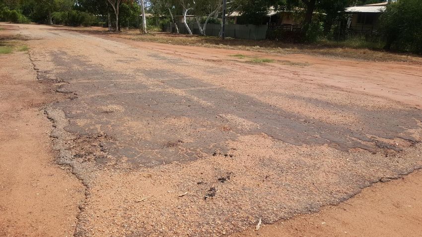
Shire of Derby/West Kimberley Road Management Strategy 2020-25 – Sealed Roads April
2020
SECTION 2. Introduction
2.1 Background
2.1.1 Relationship between the Sealed Road Management Strategy and Legislation
The Local Government Act 1995 and the Local Government Regulations 1996 establish the powers, duties
and functions of Local Government authorities.
The Department of Local Government Integrated Planning and Reporting Framework (the Framework)
and its Guidelines outline the minimum planning and reporting methodology to achieve the outcomes
prescribed in the legislation. They are not intended to restrict the range of processes that may be
undertaken within a local government to achieve those outcomes. The Framework also requires Local
Government authorities to develop and publish road management plans incorporating the performance
of their duties in relation to the inspection, maintenance and repair of roads, having regard to the type of
road, the resources available to the council and its budgetary and policy priorities.
2.1.2 Purpose
The purpose of this Road Asset Management Strategy is to ensure Council has in place a plan that helps
Council to achieve the following objectives –
1. Ensure that a safe and efficient network of Shire public roads is provided primarily for travel and
transport.
2. Provide a structure for a road management plan which will ensure that the public roads in the Shire
of Derby/West Kimberley –
are capable of functioning as they were built to function;
are able to meet future needs in a growth environment; and
continue to meet the needs and expectations of the community and other key stakeholders.
3. Within that structure, advance Council’s road management practice to achieve the strategic
objectives of Council’s Strategic Community Plan 2012-2021.
4. Prioritise management to provide the best value for money to the community whilst respecting
budget restraints.
5. Adhere to good practice of road construction and management.
2.1.3 Execution
To achieve the objectives in Clause 2.1.2, this Strategy provides details in the following key management
areas that are central to Council’s role as the road authority for municipal public roads –
a) Provide descriptions of the types of road and road-related infrastructure assets covered by this
Strategy.
b) Set up a road hierarchy classification to facilitate the setting of performance standards. The
details are in Section 4, Road Infrastructure Hierarchy.
c) Set relevant performance standards to help with the discharge of Council’s duties. The details are
in section 5, Performance Standards.
d) Address network wide challenges faced by the road network. The details are in section 6,
Network Challenges and Potential Solutions.
2.1.4 Key Stakeholders
Key stakeholders who will be affected by this Sealed Road Management Strategy in the Shire of Derby /
West Kimberley include –
The community - ratepayers, residents, business, industry, health, education.
Road users such as pedestrians, bicyclists, motorcyclists, public transport passengers and vehicle
drivers and passengers.
Page | 5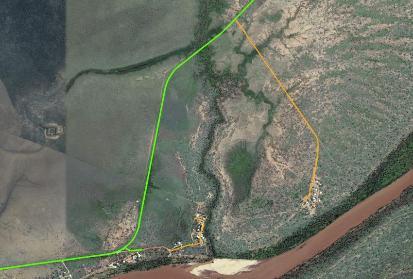
Shire of Derby/West Kimberley Road Management Strategy 2020-25 – Sealed Roads April
2020
Transport service providers - transport operators, bus operators and service providers supporting
the delivery of transport and freight services.
Emergency services.
Public Utilities such as water, sewerage, drainage, electricity, telephone, telecommunications and
other like services
Land / mine developers and their respective consultants and contractors.
Road authorities / agencies of State and Federal governments.
Federal and State government departments and agencies such as the Department of Housing, the
Department of Health, the Department of Indigenous Affairs and the Parks and Wildlife Service.
Private road owners such as pastoral stations, indigenous communities, business, industry, body
corporate.
Elected representatives.
Council staff and consultants and contractors.
2.1.5 Duty of road users
Whilst Council has certain duties and responsibilities, this Plan is predicated on the basis that the road
users also have certain obligations and responsibilities to drive safely according to the prevailing
conditions, to have regard to the rights of other road users, the community and infrastructure managers,
and to avoid damaging infrastructure.
2.1.6 Budget
The annual Budget has been developed within an overall financial planning framework that guides Council
in identifying community needs and expectations over the short, medium and long term. In preparing the
annual Budget, funding requirements for each year are linked with the objectives contained in the
Strategic Community Plan 2012-2021
In relation to road and road-related infrastructure assets that provide road transport service, Council
recognises the importance of balancing appropriate performance standards with what the communities
able to afford and sustain. In balancing the funding level for the inspection, maintenance, repairs, upkeep,
rehabilitation and renewal of road and road-related infrastructure assets, Council gives regards to the
following key considerations –
preservation of existing assets in an appropriate and safe working condition;
market constraints in manpower, plant and equipment, building materials and contractors; and
budget / financial constraints.
The performance standards set in Section 5 of this Plan reflects such balance.
Appendix 1 details the proposed 5 Year Funding Programme. Funding sources for this programme
include:
Road Project Grants – funded 2/3 Main Roads WA Regional Road Group to 1/3 Local Government
Roads to Recovery – 100% Commonwealth funded, funding restricted to road infrastructure,
current programme expires 30 June 2024
Federal Assistance Grant (FAG) – road portion of grant, no restriction on eligible projects
Direct Grant – restricted to use on road projects
Remote Aboriginal Access Roads (RAAR) – funding not included in Appendix 1 as this funding is
restricted for rural roads which are generally unsealed. Funding apportioned 2/3
Commonwealth, 1/3 State
Blackspot – restricted to approved projects based on either Crash Statistics or Road Safety Audit.
Federal Blackspot 100% Commonwealth funded, State Blackspot 2/3 State and 1/3 Local
Government funded.
Page | 6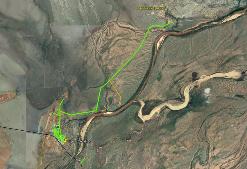
Shire of Derby/West Kimberley Road Management Strategy 2020-25 – Sealed Roads April
2020
SECTION 3 – Road Asset Description
This section provides the details of road infrastructure and road-related infrastructure assets that are
being covered under this Plan.
3.1 Overview
The Shire of covers an area of approximately 119,842 square kilometres, with a population of
approximately 8,300 persons spread between towns, communities and pastoral stations.
In regard to rural roads, and town sealed roads assets the Shire is responsible for –
101.36 kilometres of sealed public roads;
Approximately 763,500m2 of sealed public roads.
Roads are measured in Single Lane Kilometres (SLK)
Sides of the road are designated according to the SLK (ie. Left / Right from SLK 0.00 to end of road)
3.2 Assets covered
The road infrastructure assets covered in this Plan are –
trafficable road pavements
Road-related infrastructure assets to be covered in future revisions of this strategy include:
kerbs
road shoulder and verge
road drains including features such as culverts and table drains
guide posts / signs
paths including footpaths and shared paths.
3.3 Roads Maintained by the Shire
Current Shire of Derby/West Kimberley policy accepts the responsibility for the maintenance of all current
public roads listed within the Shire’s RAMM database. Some roads are also identified as part of Main
Roads WA’s “Roads 2030 Regional Road Development Strategies” identifying them as a road of
significance where additional funding may be available through the annual Road Project Grants funding
programme.
3.4 Existing Condition of Shire Roads
The existing condition of the Shire’s roads vary quite considerably from road to road and across the Shire.
It is proposed that the works programme shall be reviewed annually and defined by a hierarchy and
inspections on the condition of the network.
Below are some photographic examples of the Shire’s road network and some of the influencing factors
that will be discussed within the hierarchy. TALIS Consultants completed a visual condition assessment of
the road network at the end of 2014 and produced a Forward Works Programme (FWP) which has been
used as a basis for the FWP contained within this Road Management Strategy.
Page | 7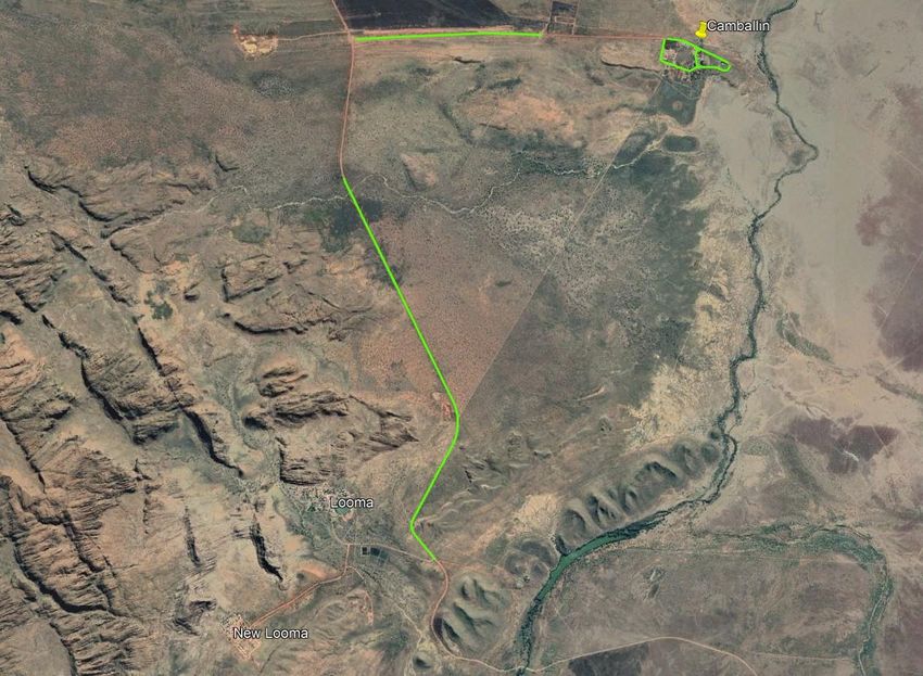
Shire of Derby/West Kimberley Road Management Strategy 2020-25 – Sealed Roads April
2020
Influencing Indicative Photograph
Element
Demand
Very High
(>1000vpd*)
High (500-
1000vpd)
Medium (200-
500vpd)
Low (100-200vpd)
High Demand Medium Demand Very Low Demand
Very Low (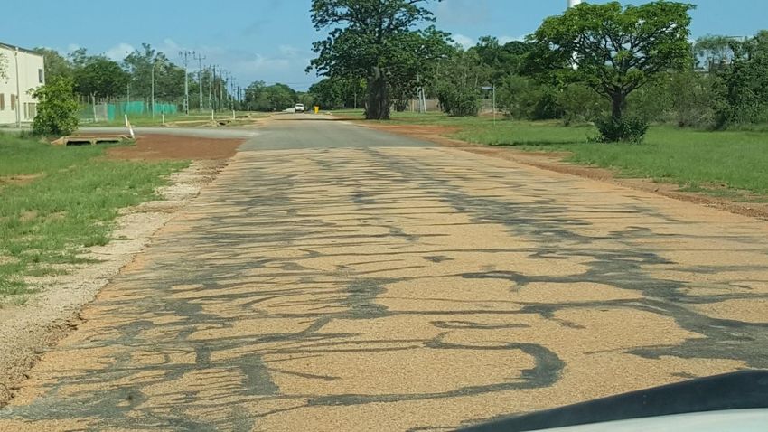
Shire of Derby/West Kimberley Road Management Strategy 2020-25 – Sealed Roads April
                                          2020

For Shire public roads, a Five tier hierarchy classification is proposed. Roads are classified through 1 to 5
in accordance with the above factors.

1 (Road Importance – Very High)

Roads of this classification are in a poor condition where routine maintenance will not increase the life of
the asset to the expected standard. Subsequently, they require urgent reconstruction to remediate any
structural pavement defects.

2 (Road Importance – High)

Roads of this classification are in a fair condition where the intervention period for pavement
reconstruction can be extended by resealing the pavement.

3 (Road Importance – Medium)

Roads of this classification are in a reasonable condition where a reseal will extend the life of the asset to
the expected standard.

4 (Road Importance – Low)

Roads of this classification are in a good condition and only require minor routine patching to maintain
the asset to the expected standard.

5 (Road Importance – Very Low)

Roads of this classification have been constructed, reconstructed or resealed within the last 5 years to
maintain the asset to the expected standard.

A Summary of each road’s proposed rating is included in Appendix 1

4.2     Road Treatment by Hierarchy
The road hierarchy as attached in Appendix 1 defines the roads in accordance with the categories selected
by the officers conducting the review. The categories defined the roads by use, what they service and
importance under both Roads 2030 and RAMM. What the hierarchy does not take into account is the
unaccountable factors that can only be determined onsite or by officers familiar with the use of the road.

Subsequently, there cannot be a road treatment by hierarchy alone. However, it can significantly help to
gain a broad understanding of the network and develop the strategy for the road treatment, along with
local knowledge around use and seasonal conditions.

4.3      Proposed Maintenance Practices
As discussed previously, options for the ongoing management of the Shire’s road network have
historically been determined using a combination of local knowledge and engineering standards. This has
resulted in some roads being reconstructed and some roads being regularly maintained, whilst other
roads have not been maintained at all.

This strategy was prepared to provide the greatest long and short term benefit to the Shire of Derby/West
Kimberley as the asset manager, and also to the thousands of users of the road whether they are pastoral
Station users, tourists or the many service agencies and other motorists travelling the road network.

4.4    Town and Rural Road Treatments
Proposed Treatments are included in the Forward Works Programme attached in APPENDIX 3.

                                                                                                    Page | 9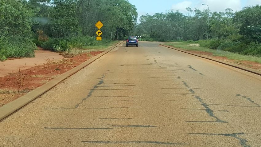
Shire of Derby/West Kimberley Road Management Strategy 2020-25 – Sealed Roads April
2020
5. PERFORMANCE STANDARDS
In this Section, Council sets the performance standards for the following operational functions in roads,
pathways and ancillary areas –
Defect inspection
Hazard identification
Defect intervention level and rectification time
5.1 Objectives
The objectives of setting performance standards –
(1) Ensure public safety – achieved by regular Hazard Inspections and being responsive to hazard
notification.
(2) Protect road infrastructure assets – achieved by carrying out regular Defect Inspections and developing
planned maintenance repairs to avoid or minimise impairment to the asset’s highest and best use
potential. This is essential for providing the best value for money for the Shire and the delivery of road
transport service at the lowest practicable cost to the communities.
(3) Ensure an appropriate level of statutory protection against civil liability claims based on balancing
available Council resources.
5.2 Hazard and Defect Inspections
These will be carried out by Technical Services staff to see how best to rectify the issue. These inspections
will use the criteria contained within the Institute of Public Works Engineering Australasia’s Practice Note
9 2015 – Road Pavements, Visual Assessment (Condition Assessment and Asset Performance Guidelines).
This document is an industry standard that rates various road conditions (eg. cracking, stripping, flushing,
edge break) from 1 to 5 and has photos corresponding to each score to assist with on-site assessment.
5.3 Hazard Identification
Hazards will be assessed by a competent Officer in accordance with the requirements of AS/ISO
31000:2018 – Risk Management – Guidelines.
5.4 Defect Intervention Level and Rectification Time
Proposed defect intervention levels and rectification times are detailed in the table in Appendix 5.
6 NETWORK CHALLENGES and POTENTIAL SOLUTIONS
The current condition of the Shire’s sealed road network is below average due to the lack of resealing that
was carried out prior to 2015. It is proposed to carry out regular inspections of the sealed roads to monitor
their condition and assist in planning for future maintenance. 2019/20 Financial Year funding is allocated
on a ratio of 86% sealed network and 14% unsealed network. The sealed to unsealed funding ratio could
vary from 60:40 to 80:20 and is subject to change due to external funding arrangements and flood damage
received during nominated storm events.
As funding criteria is expected to get more stringent into the future, the Shire of Derby/West Kimberley
will need to investigate options available to maximise work undertaken for the available funding, and
subsequently providing best value for money for the community.
Page | 10Shire of Derby/West Kimberley Road Management Strategy 2020-25 – Sealed Roads April
2020
Currently, the only local source of sealing aggregate in the West Kimberley is Kimberley Quarries at
Nillibubbica between Derby and Broome. The next closest source is the Tabba Tabba Quarry located
approximately 50km east of Port Hedland. This lack of a local source of sealing aggregate means that the
amount of resealing able to be completed is reduced due to the cost of transporting the aggregate from
the quarry to site.
7 REVIEW OF SEALED ROAD MANAGEMENT STRATEGY
The review of this Sealed Road Management Strategy will be continual as the Technical Services
Department will closely monitor the road network to ensure a “Best Value for Money Spend” by the Shire
and a useable network of roads, unless otherwise directed by the Council and/or the CEO.
8 DEFINITIONS
“Act” is the Local Government Act 1995.
“Ancillary area” is any area designated by the Shire used by motor vehicles and cyclists
connecting to a roadway, for example, car park, rest stop or recreation facility.
“Arterial roads” are highways and declared main roads, which are managed by the state
government through Main Roads WA.
“Bridge and major culverts” means a structure having a clear span greater than 1.80 metres or
a pipe culvert having a waterway area greater than 3 square metres.
“Defect” means any form of failure in the road surface, including potholes, displaced pavement,
cracking and road collapses. These types of failure can be structural and/or visual in nature.
“Maintenance” with respect to roads is defined to mean repairs to pavement failures. These
repairs take the form of pothole patching to heavy patching. The purpose being to make the road
trafficable until reconstruction works can be carried out.
“MRWA” refers to Main Roads Western Australia
“Municipal roads” are roads for which the Shire is the responsible road authority and are listed
in the RAMM inventory that details the Shire’s road network.
“Non-road infrastructure” means infrastructure in, on, under or over a road which is not road
infrastructure and includes water and sewerage mains, telecommunication cables, electricity
poles and street lights, bus shelters, vegetation and the like.
“Pathway" means a footpath, shared path or recreational path constructed or developed by the
Shire for use by members of the public other than with a motor vehicle and does not include any
pathway which has not been constructed by or for the Shire or with its approval.
“Private roads” include roads in reserves, roads to and in indigenous communities and roads on
private property, pastoral leases, private pathways or any crossovers providing access from
private properties to a public road or public highway. The Shire is not responsible for the care
and maintenance of these roads, pathways or crossovers.
“RAV” means a Restricted Access Vehicle such as a “B-Double” or roadtrain that is restricted to
travelling on MRWA approved routes.
“RAMM” is the Road Asset and Maintenance Management database detailing road assets and
associated infrastructure maintained by the Shire.
“Response time” is the time to respond to a hazard or defect measured from when the hazard
or defect is identified by or notified to the council. Days to respond are business days, ie Monday
to Friday, 5 days per week excluding public holidays.
“Roads 2030 Significant Road” means a municipal road that has been included in the Main Roads
WA “Roads 2030 Regional Strategies for Significant Local Government Roads” and is eligible for
funding from MRWA Regional Road Group Road Project Grants;
“Road infrastructure” means infrastructure which forms part of a roadway, pathway or
shoulder including-
Page | 11Shire of Derby/West Kimberley Road Management Strategy 2020-25 – Sealed Roads April
2020
(i) Structures forming part of the roadway, pathway or shoulder; and
(ii) Materials from which a roadway, pathway or shoulder is made.
This also includes bridges, culverts, floodways / causeways, plus materials such as asphalt,
bitumen, gravel, line marking, guideposts and signs.
“Road-related infrastructure” means infrastructure which is installed or constructed by the
relevant road authority for road-related purposes to—
(i) Facilitate the operation or use of the roadway or pathway; or
(ii) Support or protect the roadway or pathway;
“Road Management Strategy” means this plan.
“Roadside” means any land that is within the boundaries of a road reserve (other than the
shoulders of the road) which is not a roadway or a pathway and includes the land on which any
vehicle crossing or pathway which connects from a roadway or pathway on a road to other land
has been constructed;
“Shire” means the Shire of Derby/West Kimberley;
“SLK” means Single Lane Kilometre, the method of measuring or locating a point on a road;
“Thoroughfare” is defined in the Local Government Act 1995 and includes a street, right of way,
cul-de-sac, bypass, bridge or ford, shared path, bicycle path, any culvert or kerbing or other land
(nature strip, roadside and private driveway not included) or works forming part of the road.
“Vehicle crossover (driveway)” is the crossing which provides access from the road to the
property boundary. The property owner is responsible for the construction and maintenance of
the crossover.
Page | 12Shire of Derby/West Kimberley Road Management Strategy 2020-25 – Sealed Roads April
2020
APPENDIX 1- FIVE YEAR FUNDING PROGRAMME
Page | 13Shire of Derby/West Kimberley Road Management Strategy – Sealed Roads Revision 1
FIVE YEAR CAPITAL SEALED ROAD FUNDING PROGRAMME SUMMARY
Description 2019/20 2020/21 2021/22 2022/23 2023/24 2024/25
Roads to Recovery Funding + $774,000 $800,000 $800,000 $800,000 $800,000 Unknown
Main Roads WA (MRWA) $700,000
Regional Road Group (RRG) $702,000 $700,000 $700,000 $700,000 $700,000
Funding #
Shire Funded Works * $693,000 $600,000 $600,000 $600,000 $600,000 $600,000
Federal Assistance Grant (FAG)
$460,000 $460,000 $460,000 $460,000 $460,000 $460,000
^
Direct Grant ^ $218,000 $218,000 $218,000 $218,000 $218,000 $218,000
MRWA State Blackspot Project basis Project basis Project basis Project basis Project basis
$804,000
Funding only only only only only
MRWA Federal Blackspot Project basis Project basis Project basis Project basis Project basis
$379,500
Funding only only only only only
Disaster Recovery Funding Project basis Project basis Project basis Project basis Project basis
$2,000,000
Arrangements (flood damage) only only only only only
Total Expenditure $6,030,500 $2,778,000 $2,778,000 $2,778,000 $2,778,000 $1,978,000
+ Current 5 year Roads to Recovery Funding Arrangements expire 30 June 2024.
# Restricted to roads (sealed and unsealed) classified as significant in the Main Roads WA “Roads 2030 Regional Strategies for Significant
Local Government Roads” document.
* Shire Funded Works includes allocation of $150,000 for Flood Damage contribution (mandatory expenditure prior to claiming
reimbursement from Disaster Recovery Funding Arrangements).
^ Funding amounts subject to change on an annual basis.
NB All figures in the above table are based on current funding. The funding in the above table also funds the capital projects on the Shire’s
unsealed road network.
Page | 14Shire of Derby/West Kimberley Road Management Strategy – Sealed Roads Revision 1
APPENDIX 2 – ROAD HIERARCHY
Regional / District Distributor (eg Loch St)
Local Distributor
(eg Ashley St)
Access Road (eg McGovern Way)
Page | 15Shire of Derby/West Kimberley Road Management Strategy – Sealed Roads Revision 1
These tables give an overall inspection ranking of the road according to data and statistics.
RAV Route No. of Businesses
No 0 1 1
Yes / Used 5 2 2
3 3
4 4
RAMM Classification >4 5
1 Access road Rec Facility 5
2 Local Distributor
3 Regional / District Distributor Visitor Accommodation
No 0
Yes 1
Zoning
Rural 0
Roads 2030 Significant Road R5 1
0 No R10 / R12.5 2
2 Yes R15 4
R20 / R25 7
R30 / R35 10
Industrial 3
Traffic Volume AADT
0-20 0
20-100 1
100-200 2
200-500 3
500-1000 4
>1000 5
Page | 16Shire of Derby/West Kimberley Road Management Strategy – Sealed Roads Revision 1
Score Table Hierarchy Number
Score Hierarchy Very High 1
1 Very Low High 2
2 Very Low Medium 3
3 Very Low Low 4
4 Very Low Very Low 5
5 Very Low
6 Low
7 Low
8 Low
9 Low
10 Low
11 Medium
12 Medium
13 Medium
14 Medium
15 Medium
16 High
17 High
18 High
19 High
20 High
21+ Very High
Page | 17Shire of Derby/West Kimberley Road Management Strategy – Sealed Roads Revision 1
Roads
Zoning Traffic Asset
Number of 2030 Visitor RAV RAMM Hierarchy Safety Total
Road # Road (R Volume School Total Hierarchy Mgmt Priority
Businesses Significant Accommodation Route Classification Number Ranking Score
Code) (peak) Ranking
Road
0134 ADCOCK ROAD 0 0 0 0 1 5 0 1 7 Low 4 3 4 11 4
0067 ALEXANDER STREET 0 4 0 0 2 0 0 1 7 Low 4 2 3 9 3
0063 ALFONSAS STREET 1 4 0 0 4 0 0 1 10 Low 4 4 3 11 4
0034 ANDERSON STREET 0 7 0 0 4 0 1 2 14 Medium 3 5 2 10 3
0058 ARCHER STREET 0 4 0 0 2 0 0 1 7 Low 4 5 4 14 5
0056 ASHLEY STREET (Panton to Loch) 5 1 2 0 3 5 0 2 18 High 2 5 2 9 3
0056 ASHLEY STREET (Loch to Alfonsas) 1 4 2 0 5 5 0 2 19 High 2 3 2 7 2
0056 ASHLEY STREET (Alfonsas to Guildford) 5 2 2 1 5 5 0 2 22 Very High 1 1 2 4 1
0056 ASHLEY STREET (south of Guildford) 0 2 2 0 4 5 0 2 15 Medium 3 3 2 8 2
0223 BALANINJANGARRI ROAD 1 3 0 0 2 0 1 1 8 Low 4 5 2 11 4
0220 BANKSIA STREET 0 4 0 0 2 0 0 1 7 Low 4 5 5 14 5
0089 BAOBAB STREET 0 4 0 0 3 0 0 1 8 Low 4 3 3 10 3
0104 BARNETT WAY 0 2 0 0 2 0 0 1 5 Very Low 5 3 3 11 4
0127 BAUHINIA PLACE 0 2 0 0 2 0 0 1 5 Very Low 5 1 3 9 3
0059 BEAVEN STREET 0 4 0 0 2 0 0 1 7 Low 4 1 3 8 2
0086 BELL CREEK WAY 1 0 0 0 2 0 0 1 4 Very Low 5 2 3 10 3
0137 BELL ROAD 5 3 0 0 2 5 0 1 16 High 2 4 2 8 2
0148 BENNING PLACE 0 1 0 0 0 0 0 1 2 Very Low 5 5 5 15 5
0152 BLOODWOOD CRESCENT 0 7 0 0 3 0 0 1 11 Medium 3 5 5 13 5
0052 BLYTHE STREET 0 4 0 0 3 0 0 1 8 Low 4 3 5 12 4
0130 BRAND STREET 1 3 0 1 3 0 0 1 9 Low 4 1 3 8 2
0122 BREARLEY STREET 5 3 0 0 3 5 0 1 17 High 2 3 3 8 2
0226 BROLGA DRIVE (Boab Estate) 0 4 0 0 0 0 0 1 5 Very Low 5 4 3 12 4
0157 BROOME STREET 2 3 0 0 2 5 0 2 14 Medium 3 3 2 8 2
0232 BROWN STREET 0 4 0 0 2 0 0 1 7 Low 4 4 4 12 4
0014 CALWYNYARDAH-NOONKANBAH ROAD (SLK 0.00-0.03) 5 0 2 0 1 5 1 1 15 Medium 3 3 2 8 2
0158 CAMBALLIN RD (GNH –Camballin turnoff) 5 0 2 1 3 5 1 3 19 High 2 3 2 7 2
0158 CAMBALLIN RD (Camballin turnoff to Camballin) 2 0 2 1 3 5 0 3 16 High 2 3 2 7 2
0022 CAMBALLIN-MYROODAH ROAD 0 0 2 0 3 5 1 2 13 Medium 3 3 2 8 2
0005 CAMBALLIN-NOONKANBAH ROAD (SLK 0.00-0.46) 0 0 0 0 2 5 0 1 8 Low 4 4 2 10 3
0057 CARNARVON STREET 1 1 0 0 2 5 0 1 10 Low 4 4 2 10 3
0173 CASSIA CLOSE 0 10 0 0 1 0 0 1 12 Medium 3 4 4 11 4
0020 CHERRABUN ROAD (SLK 0.00 – 0.03) 3 0 2 0 2 5 0 1 13 Medium 3 3 3 9 3
0019 CHRISTMAS CREEK ROAD (SLK 0.00-0.03, 1.20-2.00) 5 0 2 0 2 5 1 1 16 High 2 2 1 5 1
0035 CLARENDON STREET (Loch to Hensman) 5 5 2 1 5 0 0 2 20 High 2 3 2 7 2
0035 CLARENDON STREET (Elder to Hardman - west bound) 5 5 2 1 5 0 0 2 20 High 2 2 3 7 2
0035 CLARENDON STREET (Elder to Hardman - east bound) 5 5 2 1 5 0 0 2 20 High 2 2 3 7 2
0075 COLEMAN STREET (CAMBALLIN T/S) 0 0 0 0 1 5 0 1 7 Low 4 5 2 11 4
0069 COLEMAN STREET (DERBY T/S) 0 5 0 0 2 0 0 1 8 Low 4 4 4 12 4
0125 CONWAY STREET 5 3 0 0 1 5 0 1 15 Medium 3 3 4 10 3
0171 COOLIBAH WAY 0 2 0 0 2 0 0 1 5 Very Low 5 4 4 13 5
0180 CORKWOOD COURT 0 2 0 0 1 0 0 1 4 Very Low 5 5 5 15 5
0217 CURTIN ROAD 1 3 0 0 0 5 0 3 12 Medium 4 1 2 7 2
0153 CYCAD COVE 0 2 0 0 1 0 0 1 4 Very Low 5 2 3 10 3
0233 CYPRESS COURT 0 2 0 0 1 0 0 1 4 Very Low 5 4 5 14 5
0065 DELEWARR STREET 1 2 0 0 3 0 0 1 7 Low 4 5 5 14 5
Page | 18
Page 18 of 51Shire of Derby/West Kimberley Road Management Strategy – Sealed Roads Revision 1
Roads
Zoning Traffic Asset
Number of 2030 Visitor RAV RAMM Hierarchy Safety Total
Road # Road (R Volume School Total Hierarchy Mgmt Priority
Businesses Significant Accommodation Route Classification Number Ranking Score
Code) (peak) Ranking
Road
0244 DELEWARR STREET SERVICE ROAD 0 10 0 0 1 0 0 1 12 Medium 3 4 5 12 4
0218 DERBY AIRPORT ROAD 5 3 0 0 1 5 0 2 16 High 2 1 2 5 1
0237 DOLLARBIRD STREET (Boab Estate) 0 2 0 0 0 0 0 1 3 Very Low 5 1 5 11 4
0077 DURACK ROAD (CAMBALLIN T/S) SLK 0.00 – 0.56 2 0 0 1 1 5 0 1 10 Low 4 5 5 14 5
0077 DURACK ROAD (CAMBALLIN T/S) SLK 0.56 – 0.98 0 0 0 0 0 0 0 1 1 Very Low 5 1 4 10 3
0172 EDGAR STREET 0 2 0 0 1 0 0 1 4 Very Low 5 2 4 11 4
0043 ELDER STREET 5 5 0 0 2 5 0 1 18 High 2 2 2 6 2
0136 EMANUEL WAY 5 3 0 1 4 5 0 1 19 High 2 3 2 7 2
0066 FAIRBAIRN STREET 0 2 0 0 3 0 1 1 7 Low 4 1 2 7 2
0114 FALLON ROAD 5 3 0 0 4 0 1 2 15 Medium 3 3 2 8 2
0143 FIELD STREET 0 1 0 0 1 0 0 1 3 Very Low 5 1 3 9 3
0113 FITZROY STREET (east of Derby Hwy) 2 0 2 0 3 0 0 2 9 Low 4 4 4 12 4
0113 FITZROY STREET (Derby Hwy to Steel St) 5 3 2 0 4 5 0 2 21 Very High 1 2 2 5 1
0113 FITZROY STREET (west of Steel St) 1 2 2 0 4 5 0 2 16 High 2 4 3 9 3
0155 FLYNN DRIVE 2 2 0 0 4 0 1 1 10 Medium 3 2 4 9 3
0119 FORREST ROAD (GNH to Fallon Rd) 4 3 2 1 5 5 0 2 22 Very High 1 2 2 5 1
0119 FORREST ROAD (Fallon Rd to Russ Rd) 1 1 2 0 3 5 0 2 14 Medium 3 4 2 9 3
0119 FORREST ROAD (Russ Rd to Buruwa) 1 1 2 0 3 5 0 2 14 Medium 3 2 2 7 2
0105 FORREST STREET (Derby) 0 3 0 0 1 0 0 1 5 Very Low 5 4 3 12 4
0135 GALVANS WAY 0 0 0 0 1 5 0 1 7 Low 4 4 5 13 5
0016 GEIKIE GORGE ROAD SLK 0.00 to SLK 0.25 0 0 2 0 3 5 0 3 13 Medium 3 1 1 5 1
0016 GEIKIE GORGE ROAD SLK 0.25 to SLK 0.55 0 0 2 0 3 5 0 3 13 Medium 3 1 1 5 1
0016 GEIKIE GORGE ROAD SLK 0.55 to SLK 1.72 0 0 2 0 3 5 0 3 13 Medium 3 1 1 5 1
0016 GEIKIE GORGE ROAD SLK 1.72 to SLK 15.78 0 0 2 0 3 5 0 3 13 Medium 3 1 1 5 1
0082 GEIKIE PLACE 0 2 0 0 1 0 0 1 4 Very Low 5 3 5 13 5
0109 GRANVILLE STREET 1 1 0 0 0 0 0 1 3 Very Low 5 1 3 9 3
0112 GUILDFORD STREET (east of Derby Hwy) 2 0 0 0 2 5 0 2 11 Medium 3 3 2 8 2
0112 GUILDFORD STREET (Derby Hwy to Millard St) 3 3 0 0 4 5 0 2 17 High 2 2 2 6 2
0112 GUILDFORD STREET (Millard St to Ashley St) 0 2 0 0 4 5 0 2 14 Medium 3 2 2 7 2
0151 HAKEA PLACE 0 2 0 0 1 0 0 1 4 Very Low 5 4 4 13 5
0062 HANSON STREET 0 3 0 0 1 0 0 1 5 Very Low 5 4 5 14 5
0044 HARDMAN STREET (Villiers to Loch) 2 5 0 1 4 0 0 1 13 Medium 3 4 5 12 4
0044 HARDMAN STREET (Loch to Clarendon) 1 5 0 0 4 0 0 1 11 Medium 3 1 4 8 2
0044 HARDMAN STREET (Clarendon to Rowan) 4 5 0 0 4 0 0 1 14 Medium 3 2 4 9 3
0046 HENSMAN STREET (Villiers St to Loch St) 1 5 0 0 4 0 1 1 12 Medium 3 3 2 8 2
0046 HENSMAN STREET (Loch St to Clarendon St) 0 5 0 0 3 0 0 1 9 Low 4 4 2 10 3
0156 HENWOOD CLOSE 0 2 0 0 1 0 0 1 4 Very Low 5 3 5 13 5
0147 HESELTINE COURT 0 1 0 0 0 0 0 1 2 Very Low 5 4 4 13 5
0064 HEYTESBURY STREET 0 3 0 0 3 0 0 1 7 Low 4 4 4 12 4
0133 HOLMAN STREET 0 4 0 0 3 0 0 1 8 Low 4 2 3 9 3
0070 HOWELL STREET 0 3 0 0 1 0 0 1 5 Very Low 5 4 4 13 5
0239 IBIS WAY (Boab Estate) 0 2 0 0 0 0 0 1 3 Very Low 5 4 4 13 5
0073 JETTY ROAD 5 3 2 0 4 5 0 3 22 Very High 1 1 2 4 1
0240 JETTY BOAT RAMP ROAD 5 3 0 0 4 5 0 1 18 High 2 1 2 5 1
0042 JOHNSTON STREET (Loch St to Clarendon St) 1 5 0 0 2 5 0 1 14 Medium 3 4 2 9 3
Page | 19
Page 19 of 51Shire of Derby/West Kimberley Road Management Strategy – Sealed Roads Revision 1
Roads
Zoning Traffic Asset
Number of 2030 Visitor RAV RAMM Hierarchy Safety Total
Road # Road (R Volume School Total Hierarchy Mgmt Priority
Businesses Significant Accommodation Route Classification Number Ranking Score
Code) (peak) Ranking
Road
0042 JOHNSTON STREET (Clarendon St to Rowan St) 5 5 0 1 3 5 0 1 20 High 2 2 2 6 2
0083 JONES PLACE 0 2 0 0 1 0 0 1 4 Very Low 5 3 5 13 5
0041 JULD STREET 1 2 0 0 2 5 0 1 11 Medium 3 2 3 8 2
0188 KINGFISHER LOOP (Boab Estate) 0 2 0 0 0 0 0 1 3 Very Low 5 1 3 9 3
0061 KNOPP STREET 0 3 0 0 1 0 0 1 5 Very Low 5 5 5 15 5
0053 KNOWSLEY STREET EAST (east of Derby Hwy) 1 1 0 0 3 0 0 2 7 Low 4 2 3 9 3
0053 KNOWSLEY STREET EAST (Derby Hwy to Carnarvon St) 1 1 0 0 3 5 0 2 12 Medium 3 2 2 7 2
0053 KNOWSLEY STREET EAST (west of Carnarvon St) 1 2 0 0 3 0 0 2 8 Low 4 3 3 10 3
0145 KNOWSLEY STREET WEST 0 3 2 0 4 0 1 2 12 Medium 3 5 4 12 4
0054 KUNAMARRA STREET 0 3 0 0 2 0 0 1 6 Low 4 2 4 10 3
0162 KURRAJONG LOOP 1 2 0 0 3 0 0 1 7 Low 4 3 4 11 4
0120 LE LIEVRE STREET 4 3 0 0 2 5 0 1 15 Medium 3 1 2 6 2
0090 LENNARD ROAD (SLK 0.00-0.91) 1 0 0 0 2 5 0 1 9 Low 4 1 2 7 2
0243 LINCOLN STREET (CAMBALLIN T/S) 0 0 0 0 0 0 0 1 1 Very Low 5 4 4 13 5
0221 LIVISTONA STREET 0 2 0 0 2 0 0 1 5 Very Low 5 4 5 14 5
0079 LOVEGROVE STREET 0 1 0 1 2 0 0 2 6 Low 4 2 3 9 3
0051 MacDONALD STREET 0 3 0 0 1 0 0 1 5 Very Low 5 1 4 10 3
0118 MacDONALD WAY 0 2 0 0 3 0 0 1 6 Low 4 4 4 12 4
0036 MARMION STREET 3 3 0 0 4 0 1 2 13 Medium 3 4 4 11 4
0078 MAXTED ST 1 0 0 0 0 0 0 1 2 Very Low 5 3 3 11 4
0091 MAY STREET 0 2 0 0 1 0 0 1 4 Very Low 5 3 3 11 4
0108 MC GOVERN WAY 0 2 0 0 2 0 0 1 5 Very Low 5 1 3 9 3
0116 MC LARTY ROAD 3 2 0 0 2 0 0 1 8 Low 4 1 3 8 2
0060 MC LARTY STREET 0 3 0 0 1 0 0 1 5 Very Low 5 3 5 13 5
0117 MILLARD ROAD 0 2 0 0 2 0 0 1 5 Very Low 5 2 5 12 4
0123 MILLARD STREET 5 3 0 0 2 5 0 1 16 High 2 2 2 6 2
0154 MIMOSA STREET 0 2 0 0 3 0 0 2 7 Low 4 4 4 12 4
0150 MINIRITCHIE PLACE 0 2 0 0 1 0 0 1 4 Very Low 5 4 4 13 5
0228 MONGER STREET 0 3 0 0 3 0 0 1 7 Low 4 4 4 12 4
0045 NEVILL STREET 5 5 0 0 5 0 0 2 17 High 2 1 3 6 2
0076 NORDELL STREET (CAMBALLIN T/S) 1 0 0 0 2 5 0 1 19 Low 4 5 5 14 5
0149 NUYTSIA WAY 0 2 0 0 1 0 0 1 4 Very Low 5 4 4 13 5
0163 ORD STREET 0 1 0 0 1 0 0 1 3 Very Low 5 4 3 12 4
0047 OWEN AH CHEE STREET 0 3 0 0 2 0 0 1 6 Low 4 3 4 11 4
0227 PANDANAS WAY 0 2 0 0 1 0 0 1 4 Very Low 5 3 4 12 4
0140 PANTON STREET 1 2 0 0 3 0 0 1 7 Low 4 2 1 7 2
0160 POOLE PLACE 0 2 0 0 1 0 0 1 4 Very Low 5 3 5 13 5
0129 RICHARDSON TERRACE 0 3 0 0 1 0 0 1 5 Very Low 5 2 3 10 3
0126 RODGERS STREET 5 3 0 0 2 5 0 2 17 High 2 2 2 6 2
0049 ROSE STREET 0 3 0 0 1 0 0 1 5 Very Low 5 2 5 12 4
0037 ROWAN STREET (Johnston St to Nevill St) 5 5 0 1 5 5 0 2 23 Very High 1 1 2 4 1
0037 ROWAN STREET (Nevill St to Monger St) 1 3 0 0 5 0 0 2 11 Medium 3 3 3 9 3
0037 ROWAN STREET (Baobab St to Dinner Tree) 0 2 0 0 3 0 0 2 7 Low 4 3 3 10 3
0068 ROWELL STREET 0 3 0 0 1 0 0 1 5 Very Low 5 1 3 9 3
0102 RUSS RD 2 1 0 0 3 5 0 2 13 Medium 3 1 2 6 2
0124 RUSS STREET 4 0 0 0 1 5 0 2 12 Medium 3 3 2 8 2
Page | 20
Page 20 of 51Shire of Derby/West Kimberley Road Management Strategy – Sealed Roads Revision 1
Roads
Zoning Traffic Asset
Number of 2030 Visitor RAV RAMM Hierarchy Safety Total
Road # Road (R Volume School Total Hierarchy Mgmt Priority
Businesses Significant Accommodation Route Classification Number Ranking Score
Code) (peak) Ranking
Road
0159 SADLER PLACE 0 2 0 0 1 0 0 1 4 Very Low 5 3 5 13 5
0107 SANDFORD ROAD 0 0 0 1 2 5 0 2 10 Low 4 1 1 6 2
0101 SCRIVENER ROAD 1 2 0 0 2 0 0 2 7 Low 4 3 4 11 4
0132 SHORT STREET 0 3 0 0 2 0 0 1 6 Low 4 2 4 10 3
0103 SKUTHORP ROAD 2 0 0 1 1 5 0 2 11 Medium 3 3 1 7 2
0183 SPINIFEX PLACE 0 2 0 0 1 0 0 1 4 Very Low 5 3 5 13 5
0146 STANLEY STREET (Loch St to Ashley St) 4 1 0 0 3 0 0 2 10 Low 4 2 3 9 3
0146 STANLEY STREET (Ashley St to Juld St) 1 1 0 0 2 0 0 2 6 Low 4 3 4 11 4
0146 STANLEY STREET (Juld St to Waycott St) 0 1 0 0 2 5 0 2 10 Low 4 3 4 11 4
0146 STANLEY STREET (Waycott St to Stanwell St) 6 1 0 0 2 5 0 2 16 High 2 5 2 9 3
0072 STANWELL STREET 3 1 0 1 2 5 0 1 13 Medium 3 4 2 9 3
0085 STEEL STREET (south of Fitzroy St) 1 3 0 0 1 5 0 1 11 Medium 3 4 2 9 3
0085 STEEL STREET (north of Fitzroy St) 1 2 0 0 2 5 0 1 11 Medium 3 3 4 10 3
0144 SUTHERLAND STREET (Loch St to Stanwell St) 3 1 0 0 3 5 0 2 14 Medium 3 4 4 11 4
0144 SUTHERLAND STREET (east of Stanwell St) 2 1 0 1 2 0 0 2 8 Low 4 3 1 8 2
0142 SWAIN STREET 1 2 0 0 3 0 0 1 7 Low 4 3 1 8 2
0219 TEATREE MEWS 0 2 0 0 1 0 0 1 4 Very Low 5 5 5 15 5
0131 TOWER PLACE 0 2 0 0 1 0 0 1 4 Very Low 5 1 4 10 3
0048 VAN EMMERIK STREET 0 3 0 0 2 0 0 1 6 Low 4 2 5 11 4
0038 VILLIERS STREET (Elder to Johnston) 3 5 0 0 3 5 1 1 18 High 2 3 1 6 2
0038 VILLIERS STREET (Johnston to Hardman) 2 5 0 1 3 0 1 1 13 Medium 3 4 4 11 4
0038 VILLIERS STREET(Hardman to Nevill) 0 5 0 0 3 0 1 1 10 Low 4 2 4 9 3
0038 VILLIERS STREET(Nevill to Hensman) 0 5 0 0 3 0 1 1 10 Low 4 3 2 9 3
0038 VILLIERS STREET (Hensman to Swain) 1 5 0 1 3 0 1 1 12 Medium 3 4 1 8 2
0071 WATT STREET 0 3 0 0 1 0 0 1 5 Very Low 5 4 5 14 5
0182 WATTLE STREET 0 2 0 0 0 0 0 1 3 Very Low 5 5 5 15 5
0141 WAYCOTT STREET 3 1 0 0 5 5 0 1 15 Medium 3 2 2 7 2
0121 WELLS STREET 5 3 0 0 3 5 0 1 17 High 2 1 2 5 1
0040 WINDJANA ROAD 1 0 0 1 3 5 0 1 11 Medium 3 1 2 6 2
0055 WODEHOUSE STREET (Ashley St to Gladstone St) 1 1 0 0 4 5 0 2 13 Medium 3 3 3 9 3
0055 WODEHOUSE STREET (Gladstone St to Derby Hwy) 4 2 0 0 3 5 0 2 16 High 2 1 2 5 1
0161 WOOLLYBUTT CORNER 0 2 0 0 2 0 0 1 5 Low 4 4 4 12 4
0128 YEEDA CLOSE 0 2 0 0 1 0 0 1 4 Very Low 5 3 4 12 4
0165 YURABI ROAD (SLK 0.00 – 0.50) 3 0 0 1 2 5 0 2 13 Medium 3 2 3 7 2
TOTAL SCORE PRIORITY
3–5 1
6–8 2
9 – 10 3
11 – 12 4
13 - 15 5
Page deliberately blank under this line.
Page | 21
Page 21 of 51Shire of Derby/West Kimberley Road Management Strategy – Sealed Roads Revision 1
APPENDIX 3 – FORWARD WORKS PROGRAMME
Page | 22
Page 22 of 51Shire of Derby/West Kimberley Road Management Strategy – Sealed Roads Revision 1
Roads
Road SLK SLK Area
Road Name Width Priority Description 2030 # Treatment Comments 2020/21 2021/22 2022/23 2023/24 2024/25
No. From To m2
Yes / No
Local
056 Ashley St 0.77 1.22 8.20 3,690 1 Yes Reconstruct “Short Stay” crossover to Baobab drain
Distributor
$629,766
Local
056 Ashley St 1.22 1.52 8.20 2,460 1 Yes Reconstruct Baobab drain to Richardson Terrace
Distributor
Local
016 Geikie Gorge Rd 4.33 5.99 6.30 10,458 1 Yes Reconstruct Continuation along straight northeast of Bungardi Creek
Distributor
Local
016 Geikie Gorge Rd 6.03 6.17 6.30 882 1 Yes Reconstruct In between floodways
Distributor
Local
016 Geikie Gorge Rd 6.22 7.33 6.30 6,993 1 Yes Reconstruct South of floodway $730,928
Distributor
Local
016 Geikie Gorge Rd 7.39 7.48 6.30 567 1 Yes Reconstruct South of Brooking Springs driveway
Distributor
Local
016 Geikie Gorge Rd 8.20 8.50 6.30 1,890 1 Yes Reconstruct East of Brooking Springs driveway
Distributor
Access
137 Bell Rd 0.00 0.68 7.40 5,032 2 No Reseal Full length $99,264
Road
Access
113 Fitzroy St 0.75 0.88 11.00 1,430 1 Yes Reconstruct Reshape drains to Steel St $26,000
Road
East boundary Derby Stock Supplies to Western
Access boundary of Centurion reconstruct and into Rodgers st –
113 Fitzroy St 0.88 1.39 7.40 3,774 1 Yes Reconstruct $357,631
Road construct spoon drain across Rodgers St and reshape
open drains to discharge storm water to Steel St
Local
035 Clarendon St 0.00 0.06 8.2 492 1 Yes Reconstruct Elder St to west end of island $49,200
Distributor
Local
035 Clarendon St 0.06 0.53 15.2 7,024 1 Yes Reconstruct West end of island to Hardman St – north carriageway $561,920
Distributor
Local
035 Clarendon St 0.06 0.53 12.2 5,734 1 Yes Reconstruct West end of island to Hardman St – south carriageway $458,720
Distributor
Access
218 Derby Airport Rd 0.44 1.50 6.00 6,960 1 No Reconstruct Halfway down hill to end around carpark $696,000
Road
Access
045 Nevill St 0.00 0.13 8.20 1,066 2 No Reconstruct Villiers St to Loch St $107,008
Road
Access
055 Wodehouse St 0.57 1.01 7.40 3,256 1 No Reconstruct Broome St to Derby Hwy $325,600
Road
Local
164 Yurabi Rd 0.00 0.50 7.80 3,900 3 No Reconstruct GNH to end of bitumen $312,000
Distributor
Local
119 Forrest Rd 0.04 1.06 7.30 7,446 1 Yes Reseal Shell entry to Fallon Rd $111,690
Distributor
Construct
Local
016 Geikie Gorge Rd 2.14 2.30 6.30 1,008 1 Yes Concrete Bungardi Creek $750,000
Distributor
Floodway
Page | 23
Page 23 of 51Shire of Derby/West Kimberley Road Management Strategy – Sealed Roads Revision 1
Roads
Road SLK SLK Area
Road Name Width Priority Description 2030 Treatment Comments 2020/21 2021/22 2022/23 2023/24 2024/25
No. From To m2
Yes / No
Access
037 Rowan St 0.00 0.51 8.20 4,182 1 No Reconstruct Johnston St to west end of island $85,632
Road
Access
044 Hardman St 0.35 0.48 11.20 1,456 2 No Reconstruct Clarendon St to Rowan St $145,600
Road
Access
126 Rodgers St 0.00 0.22 8.50 1,870 2 No Reconstruct Fitzroy St to south side of Hardy’s $187,000
Road
Access
155 Flynn Dve 0.00 1.34 7.40 10,264 3 No Reseal Forrest Rd to end $153,960
Road
Access No
045 Nevill St 0.17 0.31 8.20 1,148 2 Reconstruct Loch St to Clarendon St $103,320
Road
Access
042 Johnston St 0.18 0.30 20-27 2,820 2 No Reconstruct Loch St to Clarendon St $225,600
Road
Access
042 Johnston St 0.33 0.49 8.20 1,312 2 No Reconstruct Clarendon St to Rowan St $118,080
Road
Access Extend culverts and widen intersection with Russ St for
126 Rodgers St 0.46 0.56 8.50 680 2 No Reconstruct $94,000
Road safer roadtrain access
Local
102 Russ Rd 0.70 2.40 7.00 11,900 2 Yes Reconstruct East of Brooking channel $952,000
Distributor
Local
016 Geikie Gorge Rd 0.00 2.14 6.30 13,482 1 Yes Reconstruct Russ Rd intersection to Bungardi Creek (~$674,100)
Distributor
Local
016 Geikie Gorge Rd 2.30 4.33 6.30 16,128 1 Yes Reseal Northeast of Bungardi Creek (~$806,400)
Distributor
Local
016 Geikie Gorge Rd 8.63 9.40 6.30 4,851 1 Yes Reconstruct West of National Park boundary grid (~$242,550)
Distributor
Access Derby Hwy to Wells St, widen intersection Wells St,
120 Le Lievre St 0.00 0.10 7.40 740 1 No Reconstruct
Road improve drainage runoff (~$104,000)
037 Rowan St 0.00 0.33 7.40 2,442 Reshape and reconstruct pavement, install kerbing on
Access
1 No Reconstruct north side with vehicle laybacks and backfill verge
037 Rowan St 0.33 0.51 10.2 1,836 Road
(~$256,680)
Local
035 Clarendon St 1.09 1.38 11.4 3,366 1 Yes Reconstruct Hensman St to Loch St (~$201,960)
Distributor
Access
044 Hardman St 0.18 0.28 8.60 860 2 No Reconstruct Loch St to Clarendon St (~$86,000)
Road
Totals $1,459,958 $1,453,471 $1,440,608 $1,433,882 $1,493,000
# Roads 2030 Significant roads eligible for Main Roads WA Regional Road Group Road project funding, usually 2:1 Main Roads WA : Shire of Derby/West Kimberley
Single coat reseal Approximately $15.00/m2
Asphalt overlay (excluding mob/demob) Approximately $80.00/m2
Rehabilitation Approximately $40.00-$50.00/m2
Reconstruction Approximately $80.00-$100.00/m2
Page | 24
Page 24 of 51Shire of Derby/West Kimberley Road Management Strategy – Sealed Roads Revision 1
APPENDIX 4 – SERVICE LEVELS
Page | 25
Page 25 of 51Shire of Derby/West Kimberley Road Management Strategy – Sealed Roads Revision 1
Current Performance Desired Performance
Key Performance Level of Service Community Performance Technical Performance Community Performance Technical Performance Actions Required to meet Resources Required Responsibility
Measure Measure desired level of service
Measure Measure Measure
Condition Sealed roads are well Customer maintenance Reactive repairs as Majority of customers Sealed network renewal Inspection, log and Operational Operations
maintained, clean and have requests reported by customers or satisfied with overall intervention at condition repair to specifications Manager /
the right quality to serve as sighted by SDWK condition of the road 4 for all components in Sealed Road
Manager
their purpose personnel network, in terms of Management Strategy
Sealed network inspected Engineering
smooth ride
and maintained within Services
Defects Register Maintenance
Analysis of logs to
Created and Intervention Levels as per
Renewed based on engineer solutions in
Maintained Sealed Road Management
anecdotal condition and problem areas.
Strategy
age Number of defects
logged reducing
Include target response
Majority of customers Meeting target response times for repairs in the
satisfied with the times for repairs when Forward Works
response time to repair implemented Programme.
seals e.g. Potholes
Car parking well Customer maintenance Maintain and renew to Majority of customers Carpark network renewal Asset register verified and Operational Operations
maintained, clean and to requests planning requirements satisfied with the overall intervention at condition responsibility for capital Manager /
required standards of and safety audits. condition of the car 4 for all components with and maintenance works
Manager
compliance parking providedShire of Derby/West Kimberley Road Management Strategy – Sealed Roads Revision 1
Shared paths are multi use, Customer maintenance Maintain and renew to Majority of customers Path network renewal Inspection, log and Operational Operations
well maintained, clean and requests planning requirements are satisfied with the intervention at condition 4 repair to specifications Manager /
and safety audits.
to required standards of overall quality and in Sealed Road
Manager
compliance comfort of paths Management Strategy
Path network is inspected Engineering
and maintained within Analysis of logs to Services
Maintenance engineer solutions in
Defects Register problem areas.
Intervention Levels
Created and contained within the Initiate target response
Maintained Sealed Road times for repairs in the
Management Strategy Sealed Road Management
Strategy.
Unsealed roads managed to Customer maintenance Grading and drainage Majority of unsealed road Unsealed network Inspection, log and Operational Manager
minimise disruption to requests chute maintenance as per users satisfied with road inspected and maintained repair to specifications Engineering
condition.
users while maintaining Unsealed Road within Maintenance in Sealed Road Services
safe road condition Management Strategy Intervention Levels Management Strategy
Defects Register contained within the Sealed
Analysis of logs to
Road Management
Created and engineer solutions in
Maintained Strategy
problem areas
Decrease in Include target response
customer times for repairs in the
maintenance Sealed Road Management
requests. Strategy
Roadside drainage pits Customer maintenance Not included in the Sealed Decrease in number of Roadside drainage pits Create specification for Operational Operations
well maintained, intact requests Road Management Strategy reported blockages maintained with maintenance of drainage Manager
and clear of debris Maintenance pits. Inspection, log and
Intervention Levels repair to this
Defects Register
contained within the specification.
Created and
Maintained Sealed Road
Management Strategy
when implemented
Function Efficient & reliably Customer Feedback Reactive improvements as Majority of residents and Monitor traffic counts in Create a program for traffic Developer Manager
traversable network, issues occur such as businesses believe the RAMM using flow monitoring inclusive of Contributions Engineering
Blackspot. Services
with well distributed network to be efficient and MetroCount. Implement recording into RAMM and around new
traffic throughout Road safety audit reliable. specific improvements as using MetroCount. subdivisions for
completed to support
municipality Blackspot application. traffic flows increase upgrade to
surrounding road
Monitor complaints Record and Monitor MRWA MetroCount training
network.
received regarding data on Blackspot locations, through
traffic disruption due to and review RAV network
routes RAMM II (WALGA)
road works.
Include breaches of RAV
Monitor complaints per
network routes reported to
year about heavy
defects register.
vehicle usage of road
network
Page | 27
Page 27 of 51Shire of Derby/West Kimberley Road Management Strategy – Sealed Roads Revision 1
Traffic control systems Customer Feedback MRWA Blackspot Majority of residents are Implement specific Check criteria contained Operational Manager
are designed to improve locations related to satisfied that wait times at improvements in next within 3 year capital Engineering
intersections Services
traffic flow and intersections are budget year at works programme and
community safety acceptable. intersections where; annual budget when
updated
Increase in traffic flow
Monitor complaints exceeds capacity of
received regarding intersection design,
traffic disruption due to Named as MRWA
road works. Blackspot or where Safety
Audit indicates
improvement is required.
Paths designed and Customer Feedback All new paths are Monitor complaints
Customer per
Satisfaction Increase width of paths to Capital Manager
managed for all concrete and year about heavy
Survey minimum 1.5m at renewal Engineering
users minimum 1.5m wide vehicle usage of road or earlier if funds allow. Services
network Add tactile tiles at
intersections
Path connectivity to Customer Feedback Path 5 year future Integrate paths into the Increase new path Update future path plan Capacity of annual Manager
centres, schools, public capital plan as budget road and open space network outside of new to a 10 year projection Shared path Engineering
transport stops and points allows networks to increase sub divisions as per Path and add to the GIS Construction Services
of interest connectivity Plan Contractor be
sufficient for
Construct paths within 12 Review tender specifications increasing
months of majority of for Shared Path workload
houses being constructed Construction
in new sub divisions.
Parking spaces are Customer Feedback Maintain planning Customer Satisfaction Increase public transport Minimum size of standard Manager
managed to ensure requirements and safety Survey opportunities to reduce parking bay to be 6.0 x 3.0m Engineering
maximum access to CBD audits. pressure on existing Services /
and Shire Facilities for all parking. Operations
vehicle types. Manager
Initiate other non-asset
solutions to parking
Cost/Affordability To provide and manage the Annual report to Operational expenses Majority of community are Record and analyse Investigate alternative Manager
services in the most cost community on within annual budget satisfied that the transport results of Resealing bitumen options Engineering
completed projects threshold
effective manner to the network represent good Programme (Polymer Modified Services
required level of service value for money Bitumen etc) on renewal
Record and analyse results
to improve surface life
from Asphalt surfacing
Capital works delivered
within budget threshold Capital projects in annual All capital works
budget are completed on projects are selected Investigate IT solution for
time and on budget based on defined road asset inspections
prioritisation and including mobile application
economic criteria
Operating expenditure
managed in accordance
with adopted budget
Page | 28
Page 28 of 51You can also read