Rural Subdivision in the Waikato District
←
→
Page content transcription
If your browser does not render page correctly, please read the page content below
Rural Subdivision in the Waikato District

   An analysis of the economic
   consequences resulting from rural
   subdivision, especially those associated
   with the decline in primary productivity
   within the subdivision and across the
   district.

Report prepared by Professor Frank Scrimgeour
               23 August 2020

                  21 August 2020                1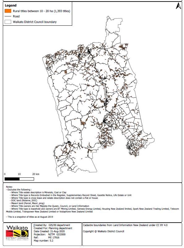
Rural Subdivision in the Waikato District

1.     Introduction

My full name is Francis Gordon Scrimgeour. I hold a Bachelor of Agricultural Science with
1st Class Honours from Lincoln College (1977) and a PhD from the University of Hawaii at
Manoa (1989). I am a Professor of Economics at Waikato University. I am also Head of the
School of Accounting, Finance and Economics. Since 1997, I have held leadership positions
at the University as a Chairperson of Department, Associate Dean, Dean, Director and Head
of School while maintaining an active programme of research.

The focus of my research is on the economics of agriculture, economics of the environment,
regional economics and financial economics. During the last 30 years, I have regularly
completed commissioned research reports for international agencies, Government
Departments, Local and Regional Government, private sector firms and industry
organisations.

I am the Editor-in-chief for the Australian Journal of Agricultural and Resource Economics
(2017-2020) and a former Editor of New Zealand Economic Papers (1998-2001). I am a past
President and Life Member of both the New Zealand Agricultural and Resource Economics
Society and The New Zealand Association of Economists. I am a Fellow of the Modelling
and Simulation Society of Australia and New Zealand. I am a Distinguished Fellow of the
Australasian Agricultural and Resource Economics Society.

I am a regular referee of research papers for leading economics journals. I have participated
in panels to review business school research across Asia, Europe and the Americas. I have
reviewed research programmes for MBIE and Crown Research Institutes.

I confirm that I have read the Code of Conduct for Expert Witnesses in the Environment
Court Practice Note 2014 and that I have complied with it when preparing this report. Other
than when I state that I am relying on the advice of another person, this evidence is within my
area of expertise. I have not omitted to consider material facts known to me that might alter
or detract from the opinions that I express.

WDC is working through a process to establish a new Waikato District Plan. One
consideration is subdivision in rural zones. This paper provides economic analysis and
reflection on matters relevant in plan development.

                                         21 August 2020                                         2
The paper reviews the publicly available information that informs this decision process and
provides analysis of alternative regulations. It should be read in conjunction with
complementary reports. It focuses on assessing the potential for losses in district productivity
associated with subdivision and the potential for adverse effects in the agricultural and related
sectors. The report consists of 7 sections, 5 sections of analysis and a conclusion.

When considering rural subdivisions a large number of issues should be considered if the
Plan is to be both built on learning from the past and provide a robust foundation for the
future.

Subdivision aspirations have evolved as a result of changing pressures. A history of
development has revealed diverse opportunities for development and alternative ways of
development. Social preferences have evolved in response to new technologies and changing
values. The evolving legal context brings new perspectives, processes and requirements for
subdivision planning. The experience of land owners, property professionals, Council officers,
and citizens all provides rich insight to inform Plan development. There is opportunity for
learning from the experiences over the life of the last Plan, especially through planning
processes.

The paper reviews the publicly available information that informs this decision process and
provides analysis of alternative regulations.

This report focuses on potential losses associated with subdivision if the District Plan is less
than optimal. The report is particularly concerned to assess the potential for losses in district
productivity associated with subdivision and the potential for adverse effects in the
agricultural and related sectors. Avoiding the loss of productive land though loss of high
quality soils and or, inappropriate parcel size, or access constraints is important. Further,
there are additional challenges associated with: landscape and rural character effects;
population density and location (reverse sensitivity effects); travel and transport. Plan
subdivision rules impact on the land owners (and future owners), neighbours, and the wider
community.

This analysis should not be read in isolation. It should be read in conjunction with
complementary reports such as those from Dr Doug Fairgray and Dr Reece Hill and the
associated planning reports including the Section 32 analysis.

                                         21 August 2020                                             3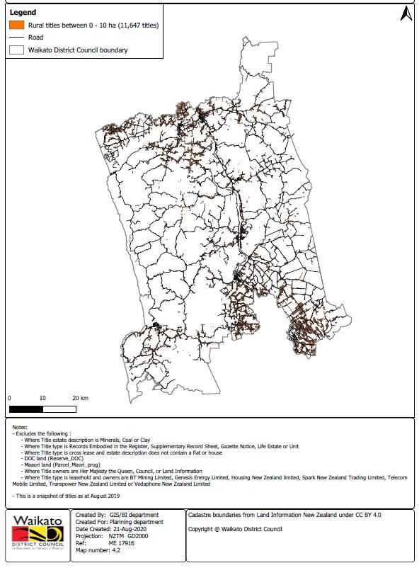
2.     Introduction to the Rural Zone and the Practice of Subdivision

The Waikato District Rural zone is the site of a range of distinctive rural activities. Waikato
rural land is used for pastoral farming where the main farming use is the grazing of livestock;
dairying farming; lifestyle land uses with titles of variable size, but larger than an ordinary
residential allotment; forestry; horticultural activities such as orchards, market gardening, and
glass houses; specialist livestock operations; mining and/or other mineral extraction;
operation of utilities; residential land; industrial; and commercial uses.

In developing an appropriate District Plan it is appropriate to recognise the nature of the rural
zone and the practice of subdivision. In establishing this local decision context it is important
to appreciate the purpose of the zone and understand its significance. These characteristics
can be compared with those of other zones in Waikato District. It is also important to
understand the process of subdivision, key variables driving the activity, and associated
timelines and impacts.

The purpose of the rural zone is to sustain productive rural communities and activities. The
proposed District Plan states Objective 5.1.1 is the strategic objective for the rural
environment and has primacy over all other objectives in Chapter 5. 5.1.1 Objective states “(a)
Subdivision, use and development within the rural environment where:

       (i) high class soils are protected for productive rural activities;

       (ii) productive rural activities are supported, while maintaining or enhancing the rural
       environment; and

       (iii) urban subdivision, use and development in the rural environment is avoided.”

The rural zone is of major significance to Waikato District. The rural zone is important in
that it includes approximately 95% of Waikato District land area and 53% of Waikato District
titles (See Table 1). This land has an estimated value of $12.8b at June 2020 and generates
annual revenue of $833m to the District. It is the home of significant agricultural,
horticultural and forest activity. This income sustains input expenditures, consumption
expenditure and investment expenditure in the region and provides a platform that underpins
significant manufacturing and service activity in the District and the upper North Island.

                                         21 August 2020                                           4
The rural zone is complementary to other zones in the District. The diversity of zones in
Waikato District can be seen with zones for Business, Business Town Centre, Heavy
Industrial, Residential and Reserves which are clearly activities that are appropriate to
separate from rural zone activities. However, it is important to note the Village zone and the
Country Living zone provide opportunities for rural living without compromising the rural
zone.
The existence of zones reduces economic and social externalities and provides synergies
through complementary economic and social activities that are near but not too close.
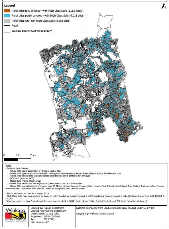
The Waikato District is home to significant areas of high quality soils. Soil surveys show that
48% of titles are partly or fully covered with high class soils, with 12% being fully covered
with high class soils. These soils are spread across the District as shown in Figure 8. They are
important because they are the most productive and versatile soils, comprising of Land Use
Capability classes 1-3.
It is important to recognise the Waikato District is already highly fragmented (see Figures 1
& 2). The large number of rural titles can be seen in Figure 3. This shows the number of titles
has continued to grow over the last 23 years. Of those issued before 6 December 1997 74%
are less than 20 ha and of those issued after 6 December 1997 82% are less than 20 ha.
Further, as Figures 4 and 5 show they are distributed widely throughout the District.
This pattern of fragmentation has occurred across the District including land that was part of
the former Franklin District Council and land that was not part of the Waikato District
Council.
Zoning and subdivision rules are further complicated by other factors such as unique
environmental features and urban expansion pressures. The planning challenge is defining
policies and rules that enable opportunities that potentially add investment to the District
while not adversely impacting rural production, the rural environment and landscape. Both
Auckland City and Hamilton population growth results in demand for country living
opportunities which can potentially occur in country living or rural zones. Further, lifestyle
opportunities such as associated with the lakes, waterways or other environmental features
may attract potential land uses which do not easily fit with land utilisation for primary
industry.
21 August 2020 5Zoning and subdivision rules must also fit with legislative requirements and associated policy
statements. Section 11 of the Resource Management Act 1991 allows the subdivision of land
where the subdivision:
Is expressly allowed by a resource consent; or
Does not contravene a national environmental standard or a district rule (including a
rule in a proposed district plan if there is one); and
Is shown on a survey plan deposited by the Registrar-General of Land or approved
by the Chief Surveyor.
Within Waikato District, the District Plan must comply with National Policy Statements, The
Waikato Regional Policy Statement, The Vision and Strategy for the Waikato River,
Futureproof 2009 (collaborative planning regime across territorial authorities) and Iwi
Management Plans.
3. The Recent History of Rural Subdivision in the Waikato
There has been considerable subdivision of rural land during the last two decades. Rural
subdivision has resulted in an increase of 118% in the number of titles between 1997 and
2020 to a total of 16,679. The largest increase has been in titles of 0-10 ha (132%) and
between 10 and 20 ha (123%). Since 1997 additional titles of greater than 20 ha size have
totalled 1,628 being 18% of the additional titles.
Rural subdivision has mostly generated benefits for the landowner. Landowner gains from
rural subdivision are inferred from the owner’s willingness to pay the costs of subdivision.
Some subdivisions are motivated by a rural land owner seeking to transfer land to new
management whilst wishing to remain in the locality. Some are motivated by the potential to
release capital. The increased value of the land is demonstrated by willingness to pay a price
for small rural parcels that exceeds their value in traditional land uses.
Rural subdivision also results in costs to the community. Productive rural land that is
converted to residential uses cannot ever be expected to be available for future production.
This is of particular concern for high class soils. Subdivision also brings external parties to
live in a rural zone whose preferences and expectations may not align with existing rural use
activity. This is known as reverse sensitivity. Further, additional buildings and developments
detract from rural character and amenity. Land fragmentation also leads to decreased
21 August 2020 6opportunities for rural production of appropriate scale. Dairy and sheep farm businesses
currently occur on land areas that are larger than the average lot size. Dairy and sheep farm
sizes reported in Council data suggest that many of these businesses comprise of more than
one land title. With increased use of technology in agriculture and horticulture it is highly
likely the optimal land area per business unit in the rural zone is likely to be larger, rather
than smaller.
There are multiple drivers of rural land subdivision for rural lifestyle. Rural subdivision is
motivated by land owners wanting to separate off a rural-residential title for personal use or
to release capital. The market for subdivided lots is largely driven by the economic centres of
Hamilton and Auckland. As these cities grow people seeking rural living options seek
opportunities within the Waikato District.
4. Potential Goals for Regulation of Rural Subdivision
When considering potential regulation of rural subdivision it is appropriate to consider
multiple goals and constraints.
Subdivision rules are about maximising social welfare over the long run. This requires
consideration of what land may be subdivided and the requirements associated with
subdivision of land. This implies it is appropriate for land to be in its most valued use. This
suggests the policy challenge is to appropriately classify land into different zones – rural;
country living etc; and maximise the value of the land within each zone. This may not
maximise the value of each individual lot within the zone. A productive rural zone has well
protected soils, access to minerals and other resources, the absence of reverse sensitivity
effects, rural landscape and character. It is also necessary to ensure environmental practices
that sustain or enhance the natural environment and land titles that are appropriate for rural
business activity.
When seeking to determine a regulatory regime that approaches optimality it is appropriate to
have a clear objective function. An appropriate objection function for a rural zone is to
maximise the net benefits within the zone from productive activities and non-market value
from zone activities plus the net effects of any external effects on other zones, less the net
costs of the infrastructure and service costs to the Council less any other external effects on
21 August 2020 7infrastructure and the environment resulting from the associated land use and population
associated with zone rules and regulations.
Explicit consideration of conflicts and trade-offs is appropriate when evaluating alternative
subdivision regulations.
More restrictive subdivision rules reduces subdivision activity. This imposes losses on those
who would have subdivided (the capital gain not achieved though land use change –
representing gains from rural living) but provide benefits through the greater area of
productive land; the greater productivity from that land; and the sustained rural landscape and
character. The challenge is to estimate the magnitude of the trade-offs and identify the
winners and the losers.
The number of titles with potential for subdivision is already constrained and these must be
identified in any forecasts of future activity.
There are 18,457 rural titles in the district without any exclusions (379,288 ha). Removal of
792 duplicate titles leaves 17,665 titles (361,606 ha). There are a further 1,733 titles with
ownership precluding subdivision leaving 15,932 titles (294,533 ha) potentially subdividable.
Of these remaining titles, 734 titles (1,137.58 ha) are affected by overlays associated with
aggregate extraction; Hamilton urban expansion or Huntly East Mine subsidence.
5. Potential Instruments for Regulation of Rural Subdivision and their Mechanism of
Impact
Waikato District Council has a range of options for addressing rural subdivision within the
District Plan. Waikato District can allow or disallow rural subdivision subject to the District
Plan complying with the Resource Management Act, National Policy Statements and other
higher order policies. The degree of restriction/permissiveness is in large measure a
subjective value judgment informed by Council aspirations pertaining to economic, cultural
and environmental outcomes and wellbeing predicated on predictions of likely land use and
behavioural choices in response to specific plan rules.
A key variable for Councils is determining the minimum size of a title that can be subdivided.
The size of parent lot has a significant relationship to the size of the new lot. Suppose a 100
ha lot has a 5 ha lot subdivided off it the reduction in the parent lot size is 5%. If a 20 ha lot
21 August 2020 8has a 5 ha lot subdivided this is a 25% reduction in parent lot size and is more likely to
constrain the potential use of the parent lot. Agriculture and horticulture are increasingly
using larger areas of land, often with multiple titles as the basis of a business unit. Dairy
farms in the Waikato average 126 ha according to DairyNZ (2020) and Waikato Sheep and
Beef Farms average 367 ha according to Beef+LambNZ (2020).
Within the Waikato vegetable growers are leasing significant areas of land and within Bay of
Plenty commercial enterprises are operating multiple orchards and some of them are
aggregating ownership of the land titles.
Another important variable is the allowable size of any new title that has been subdivided
from a parent title.
A subdivided lot in a rural area has potential to be used as a productive unit for agriculture,
horticulture or some other productive rural land use. Alternatively it can be used for rural-
residential lifestyle living but within a rural zone. If such a lot is too big it potentially results
in underutilised land. If it is too small it can result in insufficient space for waste disposal and
conflicts with the minimum size requirements for the country living zone (5,000m2).
Another instrument used in some circumstances is that of transferable development rights.
This approach is not considered further in this report for two reasons. Firstly, there needs to
be an adequate area of land where there is potential for the development right to be
transferred to. Secondly, preliminary analysis suggests that at best it will have a modest
impact on the issue relative to the complexity of the process from the perspective of citizens
and Council personnel.
6. Potential Outcomes from Alternative Regulatory Regimes
This analysis has considered the outcomes from a range of regulatory scenarios. The first
scenario was to assume that regulations were left substantially as they are in the Waikato
section of the District Plan (status quo) – with one regime across the district. The second
scenario was to consider a regulatory regime with a larger parent size requirement (minimum
40 hectares) and a relatively flexible child lot size and the third scenario was to consider a
regulatory regime with a larger parent size requirement (40 hectares) and a larger child lot
size (5000m2). Other scenarios were considered but not reported.
21 August 2020 9Each scenario was evaluated against a common set of criteria. The criteria used to evaluate
the alternative scenarios were: The number of new lots established; the impact on rural output;
and the number of properties exposed to reverse sensitivity effects.
Scenario 1 - The status quo of 320 new small lots per year
This scenario has significant risks for the District. The status quo development path could
result in an additional 3,520 lots in the District by 2030 encompassing 17,600 ha. At this rate
22% of existing titles in the zone would be subdivided. This has the potential to reduce gross
primary industry revenue into the district by $70.8m per annum and potentially have a
negative impact twice that given a multiplier effect associated with expenditure on inputs and
expenditure from wages and profits. Such a rate of subdivision would potentially increase
District asset values for 3,520 land owners but this consumptive value from Rural-residential
lifestyle living in a rural zone has modest impact on cash flows though the District assuming
the residential type cash flows would occur whatever zone a given person lived in. The
annual loss of revenue plus second round impacts from each new title comes close to
equalling the value of employment of one median employee in the District.
Scenario 2 - A Parent lot requirement of 40 ha for subdivision
This scenario has potential benefits for the District but still has challenges associated with it.
The scenario 2 development path could result in an additional 1,536 lots in the District by
2020 encompassing 7,620 ha. This results in fewer existing titles being subdivided due to the
titles of less than 40 hectares being unable to subdivide. This still has the potential to reduce
gross primary industry revenue into the district by $33.5m per annum and potentially have a
negative impact of twice that. This scenario also has the potentially to increase District asset
values but as with the status quo scenario it is not associated with significant additional
financial flows.
Scenario 3 - The 40 hectare parent lot requirement with child lot constraints
The potential benefits for the District appears to be the largest with this scenario. The
scenario 3 development path could result in an additional 1,075 lots in the District by 2020
encompassing 5,334 ha. This results in fewer existing titles being subdivided. This still has
21 August 2020 10the potential to reduce gross primary industry revenue into the district by $23.4m and
potentially have a negative impact of which is much larger. This scenario would potentially
increase District asset values but with the status quo scenario it is not associated with
significant additional financial flows.
Each scenario has implications for stakeholders. The impact of alternative scenarios on
different stakeholders was identified as follows:
All rural title holders gain from greater restrictions through less reverse sensitivity
impacts on their operations and greater protection of landscape values.
Potentially subdividing title holders lose out on the loss of capital gain from
subdivision.
Firms (and employees of firms) who supply inputs or purchase outputs gain from the
greater restrictions subdivision.
Rural residents may gain socially from higher rural population densities but it should
be noted the majority of rural residents in the Waikato are located within a modest
distance from towns, cities and service centres, unlike some more dispersed and
isolated districts.
Waikato District Council gains more revenue but experiences more costs by allowing
subdivision in the rural zone. Further, rural subdivision does not sit comfortably with
Council planning goals.
Restrictions on parent lot size have a more predictable effect on the number of new
lots created. It is harder to accurately determine the magnitude of the impact of child
lot restrictions.
Restrictions on subdivision potentially increases the value of those lots that are able to
be subdivided and the value of existing and new lots in the country living zone.
Unsatisfied demand for rural living due to restrictions on subdivision within the rural
zone suggests the Council may wish to consider the capacity of the existing Country
Living zone and the Village zone as to whether or not this should be expanded.
It is plausible that all scenarios are potentially similar in the environmental effects given that
environmental policies and regulations should mitigate any risks associated with land use
change.
There are a number of confounding factors and risk factors that suggest caution when
interpreting these results. A number of exogenous factors have the potential to impact current
21 August 2020 11forecasts. Demand for rural-residential living may increase or decrease based on economic
circumstances and policy changes in other territorial authority areas. Further, the demand for
rural-residential living in the rural zone in part depends on the amount of alternative land
available in the country living and village zones. A possible concern is that restrictions may
in part move the demand for subdivision to properties of a larger size and potentially
undesirable locations.
7. Conclusions
There is a compelling case for seeking to limit the subdivision in the rural zone of Waikato
District. The current trajectory of rural subdivision within Waikato District is transforming
rural character and landscapes within the zone. Unless there is planning changes the result
will be the area of rural-residential living within the rural zone will exceed the area of dairy
farm land. This is of itself not an issue but there is the challenge of approximately $70m of
direct revenue taken out of the rural zone and in excess of another $70m of expenditures
within the Waikato region.
The most effective way to limit subdivision within the rural zone is to place a higher
minimum parent lot size to allow subdivision.
Restricting subdivision to parent titles of greater than 40 hectares substantially limits the
number of potential subdivisions. This could halve the economic losses to the community but
each new title created still reduces District income by nearly as much as one FTE employed
in the economy.
Specifying size restriction on the lots created also reduces the potential for subdivision.
Restrictions on the size of new lots further slows subdivision and provides some benefits.
However the benefits largely rate to the factors such as consistency of planning rules
associated with people living in the rural zone.
The enhancement of WDC information systems will improve analysis, forecasting and
reporting. Enhanced information systems and data collection have the potential to enhance
the efficiency of Council officers, planning processes and the analysis by researchers, land
owners and other interested parties.
21 August 2020 12Table 1 Waikato District Council Zone Statistics
Approx. area Standard
covered by zone Approx. number of Average size of titles deviation of size Coefficient
(ha) titles (ha)1 of titles (ha) of variation % of area % of titles
ZONES
1 Business 118 372 0.32 1.33 4.2 0.0% 1%
2 Business Town Centre 35 356 0.10 0.23 2.4 0.0% 1%
3 Country Living 2,941 2,562 1.15 2.25 2.0 0.7% 7%
Village 372 1,246 0.30 1.78 6.0 0.1% 4%
Village 1000 341 134 2.54 6.03 2.4 0.1% 0%
5 Industrial 663 352 1.88 4.94 2.6 0.2% 1%
6 Heavy Industrial 216 27 8.02 14.79 1.8 0.1% 0%
7 Rural 379,288 18,457 20.55 69.24 3.4 95.3% 53%
8 Residential 2,421 10,925 0.22 1.82 8.2 0.6% 32%
9 Reserve 11,531 245 47.06 632.99 13.4 2.9% 1%
Total 397,925 34,676 100.0% 100%
1
Note: in some zones there are a number of tiny titles which may skew these numbers
21 August 2020 13Figure 1 Waikato District size distribution of rural titles (4 - 100 ha)
896
1000
900
800
Number of titles
700
600
500
375
400
287
229
220
214
300
184
167
147
145
144
137
130
122
117
117
114
101
200
99
93
77
76
74
73
66
65
64
63
61
58
57
57
56
55
55
50
49
47
46
46
45
42
40
39
39
38
37
35
34
33
33
33
32
32
32
31
30
30
29
27
100
26
25
25
24
24
23
21
21
20
20
19
18
17
17
17
16
16
16
15
15
15
14
14
14
13
13
12
12
12
12
12
11
11
9
9
9
9
0
100
4
6
8
10
12
14
16
18
20
22
24
26
28
30
32
34
36
38
40
42
44
46
48
50
52
54
56
58
60
62
64
66
68
70
72
74
76
78
80
82
84
86
88
90
92
94
96
98
Ha
Notes:
- Excludes the following :
- Where Title estate description is Minerals, Coal or Clay
- Where Title type is Records Embodied in the Register, Supplementary Record Sheet, Gazette Notice, Life Estate or Unit
- Where Title type is cross lease and estate description does not contain a flat or house
- DOC land (Reserve_DOC)
- Maaori land (Parcel_Maori_prog)
- Where Title owners are Her Majesty the Queen, Council, or Land Information
- Where Title type is leasehold and owners are BT Mining Limited, Genesis Energy Limited, Housing New Zealand limited, Spark New Zealand Trading Limited, Telecom Mobile Limited, Transpower New Zealand
Limited or Vodaphone New Zealand Limited.
- This is a snapshot of titles as at August 2019
21 August 2020 14Figure 2 Waikato District size distribution of rural titles (101 - 1000+ ha)
16
14
12
Number of titles
10
8
6
4
2
0
101
119
137
155
173
191
209
227
245
263
281
299
317
335
353
371
389
407
425
443
461
479
497
515
533
551
569
587
605
623
641
659
677
695
713
731
749
767
785
803
821
839
857
875
893
911
929
947
965
983
Ha
Notes:
- Excludes the following :
- Where Title estate description is Minerals, Coal or Clay
- Where Title type is Records Embodied in the Register, Supplementary Record Sheet, Gazette Notice, Life Estate or Unit
- Where Title type is cross lease and estate description does not contain a flat or house
- DOC land (Reserve_DOC)
- Maaori land (Parcel_Maori_prog)
- Where Title owners are Her Majesty the Queen, Council, or Land Information
- Where Title type is leasehold and owners are BT Mining Limited, Genesis Energy Limited, Housing New Zealand limited, Spark New Zealand Trading Limited, Telecom Mobile Limited, Transpower New
Zealand Limited or Vodaphone New Zealand Limited.
- This is a snapshot of titles as at August 2019
21 August 2020 15Figure 3: Waikato District rural titles by size and issue date
(not cumulative)
6,611
7,000
Issue date BEFORE 6Dec1997
6,000
5,011
Number of titles
Issue date AFTER 6Dec1997
5,000
No issue date
4,000
3,000
2,000
767
625
500
376
346
1,000
321
311
276
235
225
166
158
143
129
90
84
77
66
65
61
25
5
2
2
1
1
0
0
0
0
0
0
0-10 10-20 20-30 30-40 40-50 50-60 60-70 70-80 80-90 90-100 100+
Ha
Notes:
- Excludes the following :
- Where Title estate description is Minerals, Coal or Clay
- Where Title type is Records Embodied in the Register, Supplementary Record Sheet, Gazette Notice, Life Estate or Unit
- Where Title type is cross lease and estate description does not contain a flat or house
- DOC land (Reserve_DOC)
- Maaori land (Parcel_Maori_prog)
- Where Title owners are Her Majesty the Queen, Council, or Land Information
- Where Title type is leasehold and owners are BT Mining Limited, Genesis Energy Limited, Housing New Zealand limited, Spark New Zealand Trading Limited, Telecom Mobile Limited, Transpower New
Zealand Limited or Vodaphone New Zealand Limited.
- This is a snapshot of titles as at August 2019
21 August 2020 16Figure 4 Distribution of rural titles between 0 and 10ha
in proposed District Plan
21 August 2020 17Figure 5 Distribution of rural titles between 10 and 20 ha
in proposed District Plan
21 August 2020 18Figure 6 Waikato District Rural Titles containing High Class soils
21 August 2020 19Table 2 Distance of new subdivisions from towns
in Waikato District
Year Average distance (km)
2006 5.07
2007 4.71
2008 5.74
2009 6.38
2010 7.10
2011 7.96
2012 9.39
2013 3.78
2014 9.03
2015 7.31
2016 7.09
2017 5.82
2018 8.03
2019 5.74
2020 6.51
Total 6.05
21 August 2020 20Appendix 1
Some key references considered when writing this report are referenced below.
Deaton, B. J., & Vyn, R. J. (2014). The effect of Ontarios greenbelt on the price of vacant farmland.
Canadian Journal of Agricultural Economics, 63(2), 185–208.
Eagle, A. J., Eagle, D. E., Stobbe, T. E., & Kooten, G. C. (2014). (2014). Farmland protection and
agricultural land values at the urban‐rural fringe: British Columbia’s agricultural land reserve.
American Journal of Agricultural Economics, 97(1), 282.
Geniaux, G., Ay, J.-S., & Napoléone, C. (2011). A spatial hedonic approach on land use change
anticipations. Journal of Regional Science, 51(5), 967–986.
Musgrave, W. (1986). Should agricultural land be protected from sub-division? – Economic
considerations. Review of Marketing and Agricultural Economics, 54(3), 70–74.
Stobbe, T. E., Eagle, A. J., Cotteleer, G., & Kooten, G. C. V. (2011). Farmland Preservation Verdicts-
Rezoning Agricultural Land in British Columbia. Canadian Journal of Agricultural Economics,
59(4), 555–572.
Vyn, R. J. (2012). Examining for evidence of the leapfrog effect in the context of strict agricultural
zoning. Land Economics, 88(3), 457–477.
Vyn, R. J. (2014). The effect of agricultural zoning on rural residential property values: An application
to Ontarios greenbelt. Canadian Journal of Agricultural Economics, 63(3), 281–307.
21 August 2020 21You can also read