Russell Forest to Whāngārei Heads - Walking Cycling - Walking Access
←
→
Page content transcription
If your browser does not render page correctly, please read the page content below
1/13/2021 Russell Forest to Whāngārei Heads — NZ Walking Access Commission Ara Hīkoi Aotearoa
Russell Forest to Whāngārei Heads
Walking
Cycling
Dif culty
Medium
Length
137 km
Journey Time
6 Days
Region
Northland
Sub-Region
Whangarei District
Part of Collections
Te Araroa - New Zealand's Trail , Te Araroa - North Island , Te Araroa highlights
https://www.walkingaccess.govt.nz/track/russell-forest-to-whangarei-heads/pdfPreview 1/11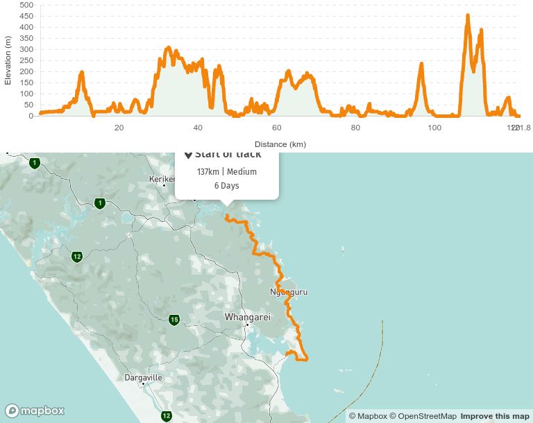
1/13/2021 Russell Forest to Whāngārei Heads — NZ Walking Access Commission Ara Hīkoi Aotearoa
Track maintained by
Te Araroa Trail Trust
Note: Some parts of Russell Forest have been affected by kauri dieback disease - Please
take care and follow instructions to wash boots on way in and way out of the forest. A Rāhui
(traditional Māori precautionary closure) has been applied at the Punaruku Road end of the
track and the entry/exit point, for the time being, is via Papakauri Road.
This is a really enjoyable section where - if you're lucky - you'll meet some of the nest Trail
Angels Te Araroa has to offer!
Russell Forest Track - 18km / 8 hours
From the Waikare landing, walk Waikare Valley Road past the Waikare School, urupā (cemetery)
and farms 3km to a road bridge across the Waikare River. It then begins to narrow, and after a
further 1km, you must cross the Waikare River. On a good day, this is no more than ankle-deep,
and you can cross adjacent to the twisted remains of a concrete power pole laid on the river
bed. It's a good opportunity to wash your boots and equipment on your way in and out of the
forest - Russell Forest has con rmed cases of kauri dieback. After rain, crossing the river can be
dangerous, please take care.
The track ahead runs parallel to the Papakauri Stream. This track is a Māori road, a surveyed
access into Māori land blocks where the public does not have access by right. It was made part
of Te Araroa after a series of meetings at Waikare Marae with the landowners. Please treat it with
respect. After 1.5km, the track tails out, and for the next 4km you're walking up the stream. This
4km across shoals and boulders will take longer than you anticipate, and you shouldn't attempt
the route after or during heavy rain. If conditions are right though, it’s a beautiful walk.
Where the stream nally intersects the Russell Forest Walkway, follow signage left (east) out to
Papakauri Road/Russell Road.
Turn right to head south on Russell Road. From the junction of Punaruku Road & Russell Road,
continue south passing the Ōākura turnoff (2.7km) and the small settlement of Mōkau (4km) until
reaching the junction of Russell Road & Webb Road, Helena Bay. From the junction of Russell &
Webb Road, follow Webb Road 1km to the start of the Helena Ridge Track.
Helena Ridge Track - 9km / 4 hours
https://www.walkingaccess.govt.nz/track/russell-forest-to-whangarei-heads/pdfPreview 2/111/13/2021 Russell Forest to Whāngārei Heads — NZ Walking Access Commission Ara Hīkoi Aotearoa
From Webb Road, climb the stile under the "High Chapparal" sign and make use of the cleaning
station to ensure no dirt/mud remains on your footwear.
We follow an old farm track that sidles around steep pasture where mānuka trees are
regenerating. Through a small patch of bush before the benched track ends and we begin to
climb a steep hill to meet a ridgeline that undulates through regenerating bush.
While there is the occasional short scramble, the track is well-formed and easy (though uphill
most of the way) walking.
Note: We come through here with agreement from a number of landowners so please respect
this and do not make camp anywhere on this track.
At the highest point, the track turns east, alternating between pasture, farm track and native
bush. Here you can enjoy glimpses of the magni cent canopy of large native trees below and the
coast in the distance.
Note: When on farm tracks you may encounter some closed gates, and often, stretchy
electri ed wires - carefully use the plastic handles to open and leave gates open or closed
as you found them.
At the very top there is another cleaning station and please use this to again carefully remove
mud from your footwear.
The last kilometre is an easy gravel farm track bringing you to Kaiikanui Road - turn left (east)
here and walk 1km to the start of the Morepork-Onekainga Track.
Morepork-Onekainga Track - 13km / 4-5 hours
From Kaiikanui Road, enter DOC’s Kaiikanui Forest and 200m in, make use of the cleaning station
to ensure no dirt/mud remians on your footwear. Follow a well-benched track for about
4km, past Hansens Hill (where the bench turns sharply northeast).
Be aware that around this 4km mark, the track moves off into the bush to the right off the bench.
At this junction, there are few large trees for markers so it can be missed. The route follows
markers through trees to meet up with the forest’s northeast boundary fence. It follows the
fenceline much of the way down into a gully before a steep climb up to a cleared and grassy
high point (218m) with spectacular views out to the coast and the Poor Knights Islands. You are
now on private land belonging to the Waetford whānau (family), so please respect the privilege.
https://www.walkingaccess.govt.nz/track/russell-forest-to-whangarei-heads/pdfPreview 3/111/13/2021 Russell Forest to Whāngārei Heads — NZ Walking Access Commission Ara Hīkoi Aotearoa
Continue on old bush tracks in a southeast direction down ridgelines to some pretty little
streams before climbing steeply all the way up again (174m down then up). At the top, you climb
stiles onto well-formed farm tracks. After 500m, turn left off the farm track and cross 200m
through a small pine plantation (there are no markers allowed on these pines so navigate
carefully) to a boundary fence just west of the Onekainga Trig (227m) and more views. Stay on
the track and follow the fenceline past the pine and then down the ridgeline in the native bush
for 1.5km. By now you have left the Waetford block, and are in the Harman’s farm and just as you
leave the bush, have lovely views over the inner Whananaki estuary. There is another cleaning
station here and again, please remove all mud from your footwear before continuing.
For the last 800m, you begin following the markers down the fenceline and then cross a pasture
(look for the lone tree) then down the other fenceline and along a small creek. There may be
magni cent Charolais bulls grazing. If so, walk slowly and quietly, waiting for them to move if
need be. At the southern end of the property, over the stile, you emerge onto Whananaki North
Road.
Please note: Private farmland and kiwi and pateke nesting area; Open daylight hours
only; No dogs, horses, bikes, guns, res or camping. Electric fences.
Walk 800m southeast along Whananaki North Road. Look for the track sign in the bush on the
south side. The track leaves the road and circles around a paddock fenceline to reach a stop
bank on the side of the Whananaki Estuary. From there, the track follows along the Estuary to the
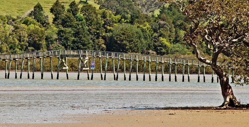
Whananaki Footbridge, entrance to the Whananaki Holiday Park and the Village.
Whananaki Coastal Track - 7km / 2.5 hours
From Whananaki North village, there’s a track next to the school which leads to the footbridge.
Once across, head east along the estuary (if the tide is high, there is a 1km detour by road
around the back of the settlement) around the small settlement and over the spit before
heading south on Pukekawa Road parallel to the shore.
There is a possible diversion via a short, steeper track to the Capitaine Bougainville Memorial
on the north point of Oruaea Bay. Great views from here along the coast.
Please note: there is limited beach access from the track. That is, only at Sheltered Bay.
Beyond Pitokuku Point, a grassy track goes behind private baches and over a stile to join up with
a well-graded pōhutukawa-lined farm track/driveway with excellent views of the coast and the
Poor Knights Islands. Continue on the driveway until reaching the gate at McAuslin Road.
https://www.walkingaccess.govt.nz/track/russell-forest-to-whangarei-heads/pdfPreview 4/111/13/2021 Russell Forest to Whāngārei Heads — NZ Walking Access Commission Ara Hīkoi Aotearoa
Leaving the gate at the north end of McAuslin Road, head south down the road and turn east
onto Matapōuri Road. Follow the road (looking out for traf c) past Sandy Bay and Woolleys Bay,
enjoying the beautiful beaches as you go. Just before Matapōuri Bay, the road climbs over a
small hill and you pass DOC’s walkway to Whale Bay, which adds a spectacular 1km to your walk
for those wanting a small diversion.
When you arrive into Sandy Bay turn right onto Matapōuri Road and head west inland for approx
3km. Turn left onto Kaiatea Road for 3.5km
Turn left into Te Toiroa Road. Stay on this road. The name of this road changes to Pukenui Road
which you follow until you turn right onto Waiotoi Road. This takes you all the way into the
seaside village of Ngunguru.
Ngunguru
From Waiotoi Road, turn right/southwest onto Ngunguru Road. Just 200m down this road is the
Ngunguru Village shops. If you need food supplies, now is a good time to get them as the next
shops on the trail are 2-3 days walk away.
The Ngunguru River Boat Crossing is another 1km walk past the shops southwest along Ngunguru
Road. Take the rst left into Pāpaka Road and walk 80m to the edge of the estuary. It is essential
to ring or text James Johnston 24 hours prior to your boat ride on 021 0242 1632.
James will do his best to pick you up at a time that suits you - text ahead to ask.
The boat arrives at Nikau Bay Camp and Cabins . Here you have the option of staying the night
either tenting or in a cabin. Hot showers and kitchen facilities are also available, all at
discounted rates to Te Araroa walkers.
1km past Nikau Bay Camp you come to a "T junction" in the road giving you 2 options to cross the
Horahora River.
OPTION 1: Turning right (West) is a free 19km mainly road detour trail.
Or
OPTION 2: Turning left (East) is a direct 3.5km Trail costing $5/person (paid at Nikau Bay
Camp) passing through private Māori land.
https://www.walkingaccess.govt.nz/track/russell-forest-to-whangarei-heads/pdfPreview 5/111/13/2021 Russell Forest to Whāngārei Heads — NZ Walking Access Commission Ara Hīkoi Aotearoa
Please note: this is a low-tide or near to low-tide trail option. You will wade through knee/waist
height water on a sand base. James at Nikau Bay Camp will provide you with tide times and
river crossing info should you decide to chose this Trail option.
Mackerel Forest Track - 4km / 1.5 hours
The track passes through private forest and may be subject to occasional closures due to
forestry operations.
Open daylight hours only.
NO dogs, guns, vehicles, camping or res.
Two river crossings - never cross ooded rivers.
From the forestry gate, the track follows Mackerel Road (a forest road) largely downhill through a
pine forest. At the bottom of the hill, it crosses the Waitangi River which is usually knee/thigh
depth. From there, the track follows the river bank through a recently harvested area of the
forest.
It then turns South to meet and cross the Tāheke River – at the shallower ford between the
deeper pools - and clambers up the southern bank. The track continues on the true right river
bank until meeting an old logging track that climbs steeply up and around a pine-covered hill
before dropping down to a logging gate on Pātaua North Road.
From Mackerel Forest Track logging gate, follow Pātaua North Road 13km to the Pātaua North
settlement.
Please note that once you near the coast, it is private land between the road and the beach
so unfortunately walking the beach is not an option here - please stick to the road.
Taiharuru Estuary Route - 7km / 2 hours
From the Pātaua River footbridge, walk south on the main road out of Pātaua. After 1.5km look
for a grassed Council Reserve on the left where Pātaua South Road runs along the Taiharuru
Estuary.
Walk through the reserve, and head southeast to the rocky point ahead.
On rounding that, and crossing the small stream, head for the 2 white marker poles out on the
sandbank.
https://www.walkingaccess.govt.nz/track/russell-forest-to-whangarei-heads/pdfPreview 6/111/13/2021 Russell Forest to Whāngārei Heads — NZ Walking Access Commission Ara Hīkoi Aotearoa
After rounding the next point, you will be facing southwest at the corner.
If you wish to cross over the estuary, proceed along the water's edge until a pole with an orange
triangle becomes visible : the shallowest place."
Tide information (use Marsden Point information)
Alternatively - to enjoy some Northland hospitality - just after the point, a wide gap in the
mangroves leads past electric fencing to an unfenced grass area. Through the gate is Beasley
Road. Turn left onto the gravel road, and Tidesong B&B is 400m ahead. "Drinks, meals, hot
shower, campsites and beds available; and a boat crossing to keep feet dry if the tide's high.".
Contact: www.tidesong.co.nz or ph 09 4361959 . Happy to accept Koha (donation).
If you are not heading to Tidesong and are ready to cross, stay well out beyond the mangroves
and head for the furthest white pole ahead (orange marker) marking the shallowest crossing
place.
Look for the prominent bare clay bank, south side, (orange marker), and walk up to cross the
stile on top. Follow the southeast fenceline over the pasture, then along a driveway to Taiharuru
Road (opposite #406).
Note: This accessway is public land. Please ensure at all times that you do not enter private
property.
Turn southwest down Taiharuru Road for 500m to Harambee Road. 1km up this road is the small
parking area.
Kauri Mountain Track - 3km / 1.5 hours
The track starts by winding up a long driveway, past private homes. (Use the stiles provided and
leave gates as you nd them as sheep sometimes graze the driveway). The coastal views north
are spectacular.
Near the top of the driveway, follow orange markers to climb over a stile & up through pasture,
then regenerating bush to the trig (where the view is blocked by bush). From there, follow the
orange-marked bush track down the southern side to Kauri Mountain Road.
Tide information: Check the best times for walking
Ocean Beach Walk - 9km / 3 hours
https://www.walkingaccess.govt.nz/track/russell-forest-to-whangarei-heads/pdfPreview 7/111/13/2021 Russell Forest to Whāngārei Heads — NZ Walking Access Commission Ara Hīkoi Aotearoa
Wildlife sanctuary:
Avoid dune nesting sites
No dogs allowed.
From the carpark, walk 2km southeast down this gravel Kauri Mountain Road to a farm gate (look
for TA logo, orange marker). Enter the paddock here, leaving this gate as you nd it, and follow
the farm track across a paddock heading straight towards Ocean Beach. A few clay steps cut into
the bank take you down to the beach.
When you're rst on the beach there is a stream/occasional estuary that changes shape a lot -
do check it before attempting to cross and on some occasions, if the tide is high you're best to
wait for the tide to drop a little.
Head south down the beach running parallel with DOC’s Ocean Beach Recreation Reserve.
Near the southern end of the beach, a sand track leads up to a carpark, toilet and Ocean Beach
Road.
Note: a freedom camping bylaw is in place that prohibits camping in this carpark.
Tide information: Check the best times for walking
Please take care when opening gates that you leave them as you nd them. There may be farm
animals on this track.
Bream Head (Te Whara) Track - 7km / 5-6hr
Note: Low tide is preferably the best time for the very rst part of this track.
Check tide information for the best times to walk .
This is a conservation area - no domestic animals are allowed (including birds, cats and dogs)
and a freedom camping bylaw means Peach Cove is the only option in the Bream Head Scenic
Reserve
Walk to the southern end of Ocean Beach and climb to the ridge beyond. The track is well
formed but steep. Continue on past a WWII naval radar station to the Bream Head/Te Whara
summit. It’s worth the short detour to the viewing platform. The rock formations & coastal views
are spectacular.
https://www.walkingaccess.govt.nz/track/russell-forest-to-whangarei-heads/pdfPreview 8/111/13/2021 Russell Forest to Whāngārei Heads — NZ Walking Access Commission Ara Hīkoi Aotearoa
Half way along the ridgeline, there is the track exiting to the north/Ocean Beach Road and
another going steeply down to the south & Peach Cove (DOC hut - not included in back-country
hut pass). This is a detour - see details in trail notes.
Continue along the ridge to Mt Lion (Matariki) then down a lot of steps to Urquharts Bay, passing
the Busby Head loop track.
Great coastal views from many parts of the track.
To continue Te Araroa south from this point onwards, you'll need to get across the channel to
Marsden Point.
Transport Across the Whāngārei Harbour
Blair Jones runs a water taxi across the Whāngārei Harbour from Reotahi where your trail
ends to the Jetty on the Ruakaka side where you trail starts again. Times he can run you
across are 11:00am and 3:00pm. The charge is $20 pp. Please contact Blair Jones - 24 hours
before on 0211147466
You can also call Peter on 0274 172440- he runs a service as well - please contact him at
least 24 hours prior.
For more information on the Whāngārei Harbour Crossing and Marsden Point please visit
Northland Regional Council
Please consider the following links around boating safety in the Whāngārei area
Northland Regional Council - safety information for boating in Northland 2018-2019
Northland Regional Council - local rules and areas to avoid while boating in Northland 2018-
2019
If you need to go to Whāngārei City to re-supply, there's good hitchhiking from here on along the
road.
From the carpark, follow Urquarts Bay Road north onto Whāngārei Heads Road. After 5km, turn
south on to Bay View Road and walk down to Little Munroe Bay.
Reotahi Track - 3km / 1 hour
https://www.walkingaccess.govt.nz/track/russell-forest-to-whangarei-heads/pdfPreview 9/111/13/2021 Russell Forest to Whāngārei Heads — NZ Walking Access Commission Ara Hīkoi Aotearoa
The wide, gravelled track begins on the lower slopes of Mt Aubrey overlooking Little Munroe Bay.
It goes around the harbour’s edge to Reotahi Beach (and boat ramp) taking in stunning sea views
and passing the historic remains of a freezing works. Very noticeable is the hum coming from the
Marsden Point Oil Re nery, just across the 1.5km channel, and the start of the Te Araroa’s next
coastal section.
Note if you are hoping to wait and nd a lift across to Marsden Point, you are better waiting
here at Reotahi than continuing around to McLeods Bay, and note that on the Te Araroa
maps, the route line ends at Reotahi
From the northern end of Reotahi Bay, there is a dirt track heading off the side of Reotahi Beach
Road. It climbs the hill to a playground at the end of Norfolk Road. Head up the road to a
driveway just past #34. Take this driveway and turn right (north) over the front lawn past the last
house. Beyond it are steps leading down to a small footbridge. This track leads to Matuku Street.
Follow this, then up to the end of Darch Point Road where a well-de ned track follows the
headland around to the jetty at McLeod Bay.
Information on the Whāngārei Harbour crossing and Marsden Point
Note: Toilets, cafe, phone, accommodation available at the Whāngārei Heads village and at
Marsden Cove marina you will nd a cafe, toilets and phone facilities.
Conditions:
Track standard: Tramping track
Potential Hazards
No dogs allowed
Multiple river crossings - please make an informed decision on tide ow and height of
the river before crossing as this can be dangerous
Do not cross rivers after or during heavy rain
Please respect trail restrictions - do not trespass onto private property
Clean boots before and after your walk to stop the spread of Kauri dieback disease
How to get here
Northern Start: Waikare
Southern End: Jetty at McLeod Bay (southern end), Whangarei Heads
https://www.walkingaccess.govt.nz/track/russell-forest-to-whangarei-heads/pdfPreview 10/111/13/2021 Russell Forest to Whāngārei Heads — NZ Walking Access Commission Ara Hīkoi Aotearoa Track Elevation and Map More information Te Araroa Northland trail notes, including information about accommodation, transport and resupplying Page last updated: Jan 5, 2021, 11:22 AM https://www.walkingaccess.govt.nz/track/russell-forest-to-whangarei-heads/pdfPreview 11/11
You can also read