Shannon Sea - Seek Ebook Sailing guide / Guide nautique NE Atlantic Ocean October 2018 - Sea-Seek
←
→
Page content transcription
If your browser does not render page correctly, please read the page content below
Shannon

                              Sea - Seek
                    Ebook Sailing guide / Guide nautique

                              Shannon

                             NE Atlantic Ocean

                               October 2018

http://www.sea-seek.com        October 2018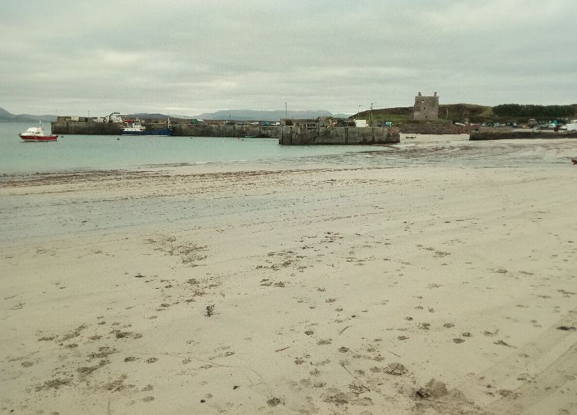
Shannon

                            Shannon

http://www.sea-seek.com   October 2018
Shannon

                                   Table of contents

       Shannon ................................................................................................................ 1
       1 - Eagle Island..................................................................................................... 2
       2 - Broadhaven ..................................................................................................... 2
       3 - Blacksod .......................................................................................................... 3
       4 - Blackrock Mayo.............................................................................................. 3
       5 - Achillbeg.......................................................................................................... 4
       6 - Inishgort .......................................................................................................... 5
       7 - Clare Island..................................................................................................... 7
               7.1 - Clare Island harbour ............................................................................. 8
       8 - Slyne Head..................................................................................................... 10
       9 - Galway........................................................................................................... 10
       10 - Cashla Bay Dir. Ligh.................................................................................. 11
       11 - Blackhead Clare ......................................................................................... 11
       12 - Eeragh.......................................................................................................... 12
       13 - Straw Island ................................................................................................ 12
       14 - Inisheer ........................................................................................................ 13
       15 - Kilrush Marina ........................................................................................... 13
       16 - Corlis Point Rear (Q................................................................................... 14
       17 - Corlis Point Front L ................................................................................... 14
       18 - Scattery Island ............................................................................................ 15
       19 - Kilcredaun Head......................................................................................... 15
       20 - Loophead..................................................................................................... 16
       21 - Little Samphire Isla.................................................................................... 16
       22 - Inishtearaght............................................................................................... 17
       23 - Cromwell Point ........................................................................................... 17

http://www.sea-seek.com                           October 2018
Shannon

24 - Valentia Dir. Lead ..................................................................................... 18
25 - Valentia Leading Lig.................................................................................. 18
26 - Skelligs......................................................................................................... 19
27 - Roancarrigmore.......................................................................................... 19
28 - Castletownbere Dir..................................................................................... 20
29 - Ardnakinna Point ....................................................................................... 20
30 - Bull Rock ..................................................................................................... 21
31 - Sheeps Head ................................................................................................ 21
Shannon

                                                                         52°47.44 N
Shannon                                                                   9°49.30 W
NE Atlantic Ocean - Shannon

The West coast of Ireland, from Mizen Head to Erris Head offers interesting and
challenging cruising among beautiful scenery. There's an abundance of excellent
natural harbours, but very few marinas, so a good anchor is a must as more often
than not, night are spend at anchor rather than in a marina!
     La cote Ouest de l'Irlande, entre Mizen head (la pointe sud) et Erris Head,
offre un des plus beau bassin de croisiere d'Europe, Les courants de maree y
sont relativement faibles, la brume rare, et de nombreux ports naturels (a defaut
de ports de plaisance equipes!) offrent un nombre d'abris surs et accessibles par

http://www.sea-seek.com          October 2018                              Page:1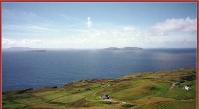
Shannon

tous les temps. Mais la houle et les vents d'ouest dominants la reserve aux
bateaux et aux equipages capables de remonter au vent dans toutes les
conditions de vent et de mer. Des bons aparaux de mouillage sont egalement
indispensables car le manque d'infrastructure oblige bien souvent a compter sur
ses ancres!
                                                                      54°17.02 N
1 - Eagle Island                                                      10°05.56 W
NE Atlantic Ocean - Shannon

White tower. Character:Fl (3) 15s
    On the 11th March 1861 at midday, the lighthouse tower was
struck by the sea,l smashing 23 panes, washing some of the lamps down the
stairs, and damaging the reflectors with broken glass beyond repair. So much
water cascaded down the tower that it was
impossible for the keepers to open the door of the tower, they had to
drill holes in it to let the water out.
    La lanterne du phare, situee, a 60 m au dessus du niveau de la mer, fut
brisee par une vague dans une tempete en mars1861. Cet incident donne un
 idee de la violence de la mer dans ces parages.
                                                                       54°16.06 N
2 - Broadhaven                                                          9°53.32 W
NE Atlantic Ocean - Shannon

http://www.sea-seek.com         October 2018                             Page:2
Shannon
White tower. Character:Iso WR 4s
Language / Langue / Lingua / Idioma
54°05.92 N
3 - Blacksod 10°03.63 W
NE Atlantic Ocean - Shannon
White tower on dwelling. Character:Fl (2) WR 7.5s
54°04.05 N
4 - Blackrock Mayo 10°19.23 W
NE Atlantic Ocean - Shannon
http://www.sea-seek.com October 2018 Page:3Shannon
White tower. Character:Fl WR 12s
53°51.51 N
5 - Achillbeg 9°56.83 W
NE Atlantic Ocean - Shannon
The beach Each of Achill Beg
Summer 2008
SE
Christophe Mouze
White round tower on square building.
Character:Fl WR 5s
Marks the South entrance of Achill sound. The fishing harbour at Cloghmore (at
the very south tip of Achill) offers good shelter in all weather, but the bar East of
Achill beg may break especially on the ebb. In bad westerly weather with swell
the south entrance of Achill sound is safe only at the end of the flood. The area
South of Achill beg can also get quite rough with a Westerly swell running against
the tide, although it is still better than on the South side of Clare Island if you must
get into Clew bay in a Westerly gale. In reasonable weather with no swell,
http://www.sea-seek.com October 2018 Page:4Shannon
Cloghmore can be entered at all time as it it is well lit (leading lights) and there's
enough water over the bar for a yacht, even at LWS.
Tide in the channel between Achill and Corraun turns about 1 hour after HW in
Westport and runs at over 4 knots.
There's a lovely anchorage off the beach East of Achill beg.
The Achill beg light also signals the North entrance to Clew bay, where the small
drying harbours of Westport and Newport offer opportunities for shopping. There
are a number of excellent anchorages in the bay.
The southern entrance to Clew bay, South of Clare Island, is not well lit, and
shouldn't be attempted at night unless one is sure of their position.
Le phare marque l'entree sud de l'etroit passage entre l'ile d'Achill et Curraun.
Le petit port de peche de
Cloghmore (a l'extreme sud d'Achill) offre un abri sur par tous les temps, mais la
barre a l'est d'Achill beg brise par grosse houle au jusant, et l'entree dans ces
conditions n'est possible qu'a la fin du flot.
La renverse entre Achill et Corraun se produit environ une heure apres le pleine
mer a Westport, et les courants atteignent 4 noeuds
Il y a un mouillage tres sympa en face de la plage a l'est d'Achill beg (voir photo).
Le phare d'Achil beg marque aussi l'entree nord de la Clew bay, au fond de
laquelle les ports d'echouage de Newport et Westport permettent de faire des
courses (et du tourisme). Il y a egalement de nombreux mouillages bien abrites et
tres pittoresques dans la baie.
53°49.59 N
6 - Inishgort 9°40.25 W
NE Atlantic Ocean - Shannon
White tower. Character:LFl 10s
http://www.sea-seek.com October 2018 Page:5Shannon
Marks the entrance to Rosmoney pier (where the Mayo Sailing club now has a
floating pontoon) and the main entrance to Westport harbour. Good anchorage E
of Inishlyre, where it is also possible to come alongside. It is also possible to
anchor in the small bay East of Collanmore island.
Local knowledge is necessary to sail into the inner bay at night.
http://www.sea-seek.com October 2018 Page:6Shannon
53°48.51 N
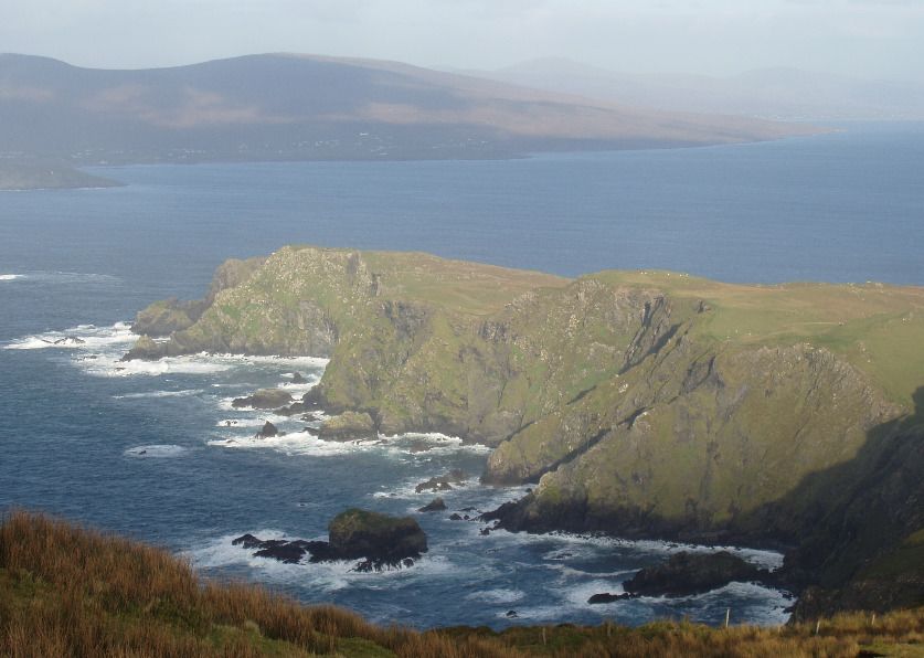
7 - Clare Island 10°00.82 W
NE Atlantic Ocean - Shannon - Clare Island
A Clare Island harbour
http://www.sea-seek.com October 2018 Page:7Shannon
View from Clare Island
View from the top of Clare island looking south
towards Caher and Inishturk, with the
Clare island
Connemara mountains in the background
The cliff at the Northern tip of Clare island viewed
unknown
from the top of the island, with Achil beg and the
SW
Southern entrance of Achill sound in the
unknown
background.
unknown Clare Island is an island guarding the
N entrance to Clew Bay. The permanent
unknown population is around 120 people and
the island
has a shop with a post office, two bars, a restaurant, a few BnBs, a primary
school and a daily ferry service to Roonagh quay.
The island is the highest of all the Irish offshore island and offers excellent hill
and cliff walking.
53°48.03 N
7.1 - Clare Island harbour 9°56.99 W
NE Atlantic Ocean - Shannon - Clare Island
http://www.sea-seek.com October 2018 Page:8Shannon
Clare island harbour
Clare island harbour viewed from the ferry en
route to Roonagh Quay, with the new pier in the
Clare Island harbour foreground on the left.
View of Clare island harbour at low tide, looking January 2017
South with the new pier on the left SE
03/01/2017 Armen
S
The harbour on Clare Island offers
Christophe Mouze
good shelter from all wind
with West in them, but is completely open to Easterlies.
Do not come alongside the new (outer) pier, which is used by ferries. It is
possible to dry out alongside the inner pier, or indeed anywhere in the inner
harbour, which has a clean, sandy bottom. There is about .5m at LWS at the end
of the inner pier, while the old stone quay completely dries out (see picture).
Shower and toilets are available at the community centre (the large building just
over the beach, North of the harbour), and there's a pub and restaurant within
easy walking distance. The shop and post office is a mile away.
In the summer, there are (free!) visitor moorings (yellow bouys).
Le port de Clare Island est bien protege des vents d'ouest, mais
completement ouvert aux vents d'est.
La nouvelle jetee exterieure est utilisee par les ferries, et les bateaux de
plaisance ne peuvent donc s'y ammarer que de facon tres temporaire. Il est
possible d'echouer le long de la jetee interieure, sur un fond de sable. En mortes
eaux, il y a environ deux metres d'eau au bout de la jetee interieure (au milieu de
la photo), et il serait donc possible d'y rester a flot.
Il y a des douches, des toilettes et une laverie sur le cote ouest du foyer
municipal (le grand batiment au dessus de la plage, qui est aussi un pub) et le
grand batiment bleu au nord du port est un hotel / restaurant. La boutique et la
poste sont au village, sur la cote sud a 15 mn de marche.
Il y a l'eau sur les deux jetees, mais pas de gasoil.
L'ete, les coffres jaunes sont des mouillages visiteurs gratuits. Sinon, on peut
mouiller sur ancre, fond de sable de bonne tenue dans l'avant port, a l'ecart des
http://www.sea-seek.com October 2018 Page:9Shannon
nombreux coffres, ou echouer dans l'arriere port ou au sud de la plage.
53°23.99 N
8 - Slyne Head 10°14.05 W
NE Atlantic Ocean - Shannon
Black tower. Character:Fl (2) 15s
53°16.20 N
9 - Galway 9°02.98 W
NE Atlantic Ocean - Shannon
Port a ecluse ou echouage. Pratique pour faire les courses, ou pour faire du
tourisme, car Galway est une grande ville, est le port est en plein centre.
http://www.sea-seek.com October 2018 Page:10Shannon
Small port. Suitable for yachts of all
size (the Volvo ocean stopped there
once). Convenient for shopping as
Galway is a major city, and the harbour
is a very short walk from the city centre.
You can dry out along one of the quays
or get a berth at the marina at the dock.
Galway is one of the main cities on the
West
cost of Ireland and has good train and bus connections, and all the services you'd
expect in a city, including a small airport.
Petit port. Galway est une des plus grandes villes de la cote ouest de
l'Irlande. Nombreux pubs, restaurants, boutiques (y compris shipchandlers),
trains pour Dublin et bus pour toutes les grandes villes et meme un petit aeroport.
53°15.83 N
10 - Cashla Bay Dir. Ligh 9°33.98 W
NE Atlantic Ocean - Shannon
White square concrete tower on column. Character:Dir Iso WRG 5s
La baie est tres bien protegee, et accessible de jour comme de nuit par tous les
temps. Par mauvais temps, Cashla bay est l'un des abris les plus surs entre
l'embouchure de la Shannon et Clew bay.
Rossaveal est un port de peche et un des ports utilises par les ferries pour les
iles d'Aran et a peu d'interet pour la plaisance, allez plutot a Roundstone, un peu
plus a l'ouest.
53°09.25 N
11 - Blackhead Clare 9°15.83 W
NE Atlantic Ocean - Shannon
http://www.sea-seek.com October 2018 Page:11Shannon
White square concrete tower. Character:Fl WR 5s
53°08.90 N
12 - Eeragh 9°51.40 W
NE Atlantic Ocean - Shannon
White towertwo black bands. Character:Fl 15s
53°07.06 N
13 - Straw Island 9°37.84 W
NE Atlantic Ocean - Shannon
http://www.sea-seek.com October 2018 Page:12Shannon
White tower. Character:Fl (2) 5s
Marque l'entree de Kileany bay, le seul abri sur des iles d'Aran.
Kilronan, a l'Ouest de la baie, est le port des ferries, et le petit port d'echouage de
Killearny, 1 km au Sud (a cote de l'aeroport), est beaucoup plus sympatique,
mais n'est accessible que deux heures de part et d'autre de la maree haute pour
un bateau calant 1.5m.
53°02.79 N
14 - Inisheer 9°31.61 W
NE Atlantic Ocean - Shannon
White tower black band. Character:Iso WR 12s
52°38.06 N
15 - Kilrush Marina 9°29.65 W
NE Atlantic Ocean - Shannon
http://www.sea-seek.com October 2018 Page:13Shannon
Small port.
Petit port de plaisance. Acces par une ecluse.
52°37.69 N
16 - Corlis Point Rear (Q 9°35.33 W
NE Atlantic Ocean - Shannon
Lattice Mast. Character:Oc 5s
52°37.09 N
17 - Corlis Point Front L 9°36.36 W
NE Atlantic Ocean - Shannon
http://www.sea-seek.com October 2018 Page:14Shannon
Concrete hut. Character:Oc 5s
52°36.34 N
18 - Scattery Island 9°31.06 W
NE Atlantic Ocean - Shannon
White tower. Character:Fl (2) 8s
52°34.81 N
19 - Kilcredaun Head 9°42.61 W
NE Atlantic Ocean - Shannon
http://www.sea-seek.com October 2018 Page:15Shannon
White tower. Character:Fl 6s
52°33.67 N
20 - Loophead 9°55.93 W
NE Atlantic Ocean - Shannon
White tower. Character:Fl (4) 20s
A l'embouchure de la riviere Shannon.
52°16.25 N
21 - Little Samphire Isla 9°52.90 W
NE Atlantic Ocean - Shannon
http://www.sea-seek.com October 2018 Page:16Shannon
Blue round stone tower. Character:Fl WRG 5s
Marque l'entree du port de plaisance de Fenit.
52°04.54 N
22 - Inishtearaght 10°39.67 W
NE Atlantic Ocean - Shannon
White tower. Character:Fl (2) 20s
51°56.02 N
23 - Cromwell Point 10°19.27 W
NE Atlantic Ocean - Shannon
http://www.sea-seek.com October 2018 Page:17Shannon
White tower. Character:Fl WR 2s
51°55.51 N
24 - Valentia Dir. Lead 10°18.41 W
NE Atlantic Ocean - Shannon
White conical tower red stripe. Character:Oc WRG 4s
51°55.46 N
25 - Valentia Leading Lig 10°18.35 W
NE Atlantic Ocean - Shannon
http://www.sea-seek.com October 2018 Page:18Shannon
White red stripe on wall. Character:Oc 4s
51°46.11 N
26 - Skelligs 10°32.51 W
NE Atlantic Ocean - Shannon
White tower. Character:Fl (3) 15s
Capraia Italien
Au moyen age, cette ile escarpee et presque inacessible etait habitee par des
moines qui y construisirent des huttes de pierres. C'est un haut lieu tourisitque,
inscrit au pratimoine mondiale de l'UNESCO.
51°39.17 N
27 - Roancarrigmore 9°44.81 W
NE Atlantic Ocean - Shannon
http://www.sea-seek.com October 2018 Page:19Shannon
White round tower black band. Character:Fl WR 3s
51°38.78 N
28 - Castletownbere Dir. 9°54.31 W
NE Atlantic Ocean - Shannon
White hut red stripe. Character:Dir Oc WRG 5s
51°37.10 N
29 - Ardnakinna Point 9°55.09 W
NE Atlantic Ocean - Shannon
http://www.sea-seek.com October 2018 Page:20Shannon
White round tower. Character:Fl (2) WR 10s
51°35.51 N
30 - Bull Rock 10°18.07 W
NE Atlantic Ocean - Shannon
White tower. Character:Fl 15s
Marks the South entrance of the Kenmare river, a most picturesque bay (despite
its name), which offers a number of safe and beautiful harbours such as Sneem
and Kilmakilloge. Darryname at the Northern entrance of the bay (North of Abbey
Island) is also a beautiful and safe anchorage but the entrance is narrow and
faces SW, so it is only suitable in settled weather.
There's a sea arch running East - West through the rock, right under the
lighthouse.
51°32.59 N
31 - Sheeps Head 9°50.92 W
NE Atlantic Ocean - Shannon
http://www.sea-seek.com October 2018 Page:21Shannon
White building. Character:Fl (3) WR 15s
Sheeps head marks the Southern entrance of Bantry bay.
Bantry bay offers a number of well sheltered anchorages accessible in all
weather: Castletown Bearhaven, a fishing harbour on the North shore of the bay
is well lit and can easily be entered at night. Adrigole, halfway up the North shore
in a picturesque anchorage perfect for a lunch time stop. Glengarrif, one of the
most beautiful harbour on the West coast (and, some would say, in the world)
offers perfect shelter in stunning scenery, while Bantry, a busy market town at the
bottom of the bay, is a good place for shopping.
To the South of Sheep's head lies Dunmanus bay, a wild and remote place with
offers little in the way of facilities, but has a few fine weather anchorages perfect
for those who like out of the way places.
http://www.sea-seek.com October 2018 Page:22Shannon
www.sea-seek.com
Responsability Responsabilité
Sea-Seek is a collection of sailing Sea-Seek est un guide du nautisme
logbooks covering harbours, ou pilote côtier en ligne. Fruit de la
anchorages, diving spots... any contribution de chacun, il décrit les
subject regarding sport or pleasure at sites de mouillage, les ports, les spots
sea. de plongée, les plages par et pour les
amoureux de la mer.
Sea-Seek is an online open-content
collaborative pilot guide, that is, a Sea-Seek est un guide nautique libre,
voluntary association of individuals c'est-à-dire une association volontaire
and groups working to develop a d'individus et de groupes qui
common resource of human développent ensemble une source de
knowledge. The structure of the la connaissance humaine. Sa
project allows anyone with an Internet structure permet à tout individu avec
connection to alter its content. Please un accès Internet et un navigateur
be advised that nothing found here Web de modifier le contenu disponible
has necessarily been reviewed by ici. En conséquence, sachez que rien
people with the expertise required to de ce que vous pouvez trouver ici n'a
provide you with complete, accurate été nécessairement vérifié par un
or reliable information. professionnel compétent dans le
domaine en question et ceci sur tous
In particular, don't use any map les sujets de Sea-Seek.
presented in Sea-Seek for the
navigation. En particulier, n'utiliser aucune carte
de Sea-Seek pour la navigation.
Note that informations in sea-seek are
compiled from a variety of freely L'ensemble des données présentées
available and non controlable sources sur Sea-Seek sont d'origines diverses
and therefore Sea-Seek webmaster et non contrôlées et ne sauraient
cannot be held responsible for engager la responsabilité du
incorrect or outdated data. responsable du site
www.sea-seek.com.
http://www.sea-seek.com October 2018 Page:23You can also read