Scientists at AOML Prepare for the 2021 Hurricane Season with New Technology
←
→
Page content transcription
If your browser does not render page correctly, please read the page content below

AOML Keynotes
NOAA’S ATLANTIC OCEANOGRAPHIC AND METEOROLOGICAL LABORATORY April-June 2021
AOML is an environmental research laboratory of NOAA’s Office of Oceanic and Atmospheric Research located on Virginia Key in Miami, Florida
Scientists at AOML Prepare for the 2021 Hurricane Season with New Technology
It’s back! June 1 marked the beginning of the 2021 Atlantic
h urricane season, and NOAA is forecasting another busy year.
With an estimated 13-20 named storms predicted to form, h urricane
scientists at AOML will continue their efforts to provide NOAA’s
National Hurricane Center and Environmental Modeling Center
with vital data needed to prepare the public for severe weather.
In collaboration with numerous partners, this summer they’ll
introduce a variety of new observing instruments, modeling
techniques, and field campaigns aimed at improving track and
intensity forecasts. Some of these new instruments will be d eployed
for the first time during NOAA’s 2021 Hurricane Field Program
(see page 2 for more information).
ALAMO floats, surface drifters, saildrones, hurricane gliders,
and other instruments will gather ocean observations from the sea
surface to depths of half a mile. These data will contribute critical
information to forecast models, advancing the knowledge of how
ocean conditions impact tropical cyclone intensity.
New this season will also be the Altius-600, a small uncrewed
aerial system launched from NOAA’s Hurricane Hunter P-3
aircraft. The Altius-600 will collect high quality measurements in NOAA GOES-East infrared satellite image of Tropical Storm Claudette on June 19.
the atmospheric layers just above the ocean surface. This turbulent Claudette became the first named storm of the 2021 Atlantic hurricane season
region, chronically undersampled, will help reveal how heat, to make landfall in the US, bringing copious amounts of rainfall to Gulf coast and
inland communities.
moisture, and momentum move b etween the ocean and atmosphere,
fueling hurricane d evelopment and leaps in s torm intensity. High-energy Observations of Radiation instrument will measure
Additionally, a compact rotational Raman Lidar will use a laser gamma radiation associated with lightning, and a Wide Swath
to measure temperature, moisture, and Saharan dust in the atmo- Radar Altimeter will measure waves at the ocean surface.
sphere from the aircraft down to the ocean surface, a Terrestrial Alongside these instruments, hurricane scientists will collabo-
rate with colleagues at the National Weather Service to run a high
resolution, moving nested version of the Hurricane Analysis and
Forecast System (HAFS), NOAA’s next-generation numerical modeling
and data assimilation platform. This updated version of HAFS,
developed at AOML, is an advance that will enable the inner core
region of tropical cyclones to be tracked at 1-2 km resolution.
HAFS will provide skilled guidance on track, intensity, and
storm structure during the 2021 Hurricane Field Program. A major
focus for field operations this year is NOAA’s Advancing the
Prediction of Hurricanes Experiment (APHEX) to be conducted
with multiple partners and focused on all stages of the tropical
cyclone lifecycle. Field campaigns will also be conducted with
NASA and the Office of Naval Research in support of APHEX.
Equipped with new observing instruments and cutting-edge
modeling capabilities this summer, hurricane scientists at AOML
Subtropical Storm Ana, the first named storm of the 2021 Atlantic hurricane will work with their partners to collect and quality control data to
season, formed northeast of Bermuda on May 22 and dissipated the following
day. Although short-lived, Ana’s development marked the seventh consecutive
help vulnerable communities plan and prepare for severe weather,
year the Atlantic hurricane season has begun earlier than its official June 1 start. supporting NOAA’s mission of building a more weather-ready nation.
2021 Hurricane Season to Feature an Array of New Technology
This hurricane season scientists at AOML will deploy an assortment of new air- and water-based uncrewed systems to improve predictions
of track and intensity, as well as use a state-of-the-art model to improve forecasts. These capabilities will additionally aid in furthering
understanding of the complex processes of how and why tropical cyclones form, strengthen (or fail to strengthen), and dissipate.
Saildrones: AOML will deploy five saildrones in the Atlantic in partnership with
NOAA’s Pacific Marine Environmental Laboratory (PMEL) in regions where tropical
cyclones typically pass. AOML and PMEL researchers will remotely pilot these
solar-powered, uncrewed surface vehicles directly into tropical cyclones to gather
upper ocean and atmospheric data. Observations from this region of wind-
whipped seas and raging winds will help scientists better understand the physical
processes for how heat is exchanged between the ocean and atmosphere,
providing energy for storms to intensify. These data will be aligned with data from
other observing instruments, e.g., hurricane gliders, to improve forecasts.
Altius-600: The Altius-600 uncrewed aerial system will be launched from NOAA’s
Hurricane Hunter P-3 aircraft to sample the lowest, most turbulent layers of the
atmosphere just hundreds of feet above the ocean surface, a region too dangerous
for crewed aircraft. This diminutive drone, only 40 inches in length and weighing
roughly 25 pounds, can cruise the inner core and eye of tropical cyclones for up to
4 hours and at distances up to 265 miles from its point of launch. The data gathered
are expected to help fill gaps in the understanding of how tropical cyclones quickly
intensity, as well as advance the ability of forecasters to predict their strength.
ALAMO Floats: Air-Launched Autonomous Micro Observer, or ALAMO, floats will
be deployed from NOAA’s Hurricane Hunter P-3 aircraft to sample ocean conditions
before, during, and after the passage of tropical cyclones. The floats will parachute
into the ocean to provide sustained observations of upper ocean temperature and
salinity, both factors that contribute to intensification. ALAMO observations will
be automatically processed and transmitted in real-time to improve the ocean’s
representation in ocean-atmosphere coupled forecast models. It is hoped this new
technology will ultimately improve predictions of track and intensity, as well as
help researchers better detect changes in intensity and overall storm structure.
Hurricane Analysis and Forecast System (HAFS): Scientists at AOML have created
the first-ever moving nest for the Unified Forecast System, the foundation of
NOAA’s weather applications. HAFS is NOAA’s next-generation numerical model
and data assimilation platform developed within the framework of the Uniform
Forecast System. Central to the development of HAFS has been the FV3 dynamical
core with an embedded moving nest to enable tracking of the inner core region
of tropical cyclones at 1-2 km resolution, key for improving hurricane structure
and intensity predictions. HAFS aims to provide reliable and skilled guidance on
tropical cyclone track, intensity, and structure, including rapid intensity changes,
genesis, and storm size. A set of new, advanced moving nest algorithms have been
developed within the Unified Forecast System for HAFS by a team of AOML and
University of Miami-Cooperative Institute scientists and software engineers. These
algorithms lay the foundation for next-generation advancements in hurricane
forecasting beyond NOAA’s current Hurricane Weather Research and Forecasting
system. HAFS is the first global weather prediction model in the world to feature
a movable nest.
2 | AOML Keynotes April-June 2021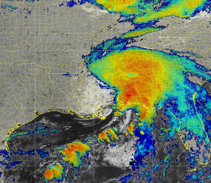
AOML Deploys Gliders in Support of Hurricane Forecasts and Research
In June, scientists at AOML and their
partners deployed five gliders in the
coastal waters off Puerto Rico and the
Dominican Republic. Their deployment
marked the eighth year of continuous
glider operations in the Caribbean Sea and
tropical-subtropical North Atlantic during
the Atlantic hurricane season.
The gliders will monitor w ater mass
properties of key ocean features that are
linked to hurricane intensification as tropical
cyclones travel through these regions. A
sixth glider will be deployed later in the
summer off of the Bahamas.
AOML gliders collect temperature,
salinity, and dissolved oxygen profile
observations to depths of 1000 m while
advancing approximately 20 km per day An AOML glider before its deployment into the coastal waters of Puerto Rico where it will spend the next
along predetermined transects where 4-5 months gathering temperature, salinity, and dissolved oxygen data to depths of 1000 meters. For more
tropical cyclones often travel and intensify. information about AOML’s glider operations, visit https://www.aoml.noaa.gov/hurricane-glider-project/.
Their missions are expected to last
4-5 months, making them some of the Glider data are transmitted in real-time b etter represented, which has been shown
longest single glider missions ever. to AOML where they are quality controlled to improve intensity forecasts. Scientists
They were deployed and are being before being transferred to data distribu- at AOML have published several studies
remotely piloted by a team of AOML and tion centers. The data are then a ssimilated showing that ocean observations are
University of Miami-Cooperative Institute into ocean and coupled ocean-atmospheric critical for improving extreme weather
scientists, science support technicians, forecast models. Their inclusion enables forecasts, with glider profile data making
and engineers. the ocean’s changing dynamic state to be one of the biggest contributions to this
improvement.
Deployment and recovery operations of
the gliders are conducted by scientists at
AOML in collaboration with partners of
the Integrated Ocean Observing System’s
(IOOS) Regional Association for the
Caribbean (CARICOOS), ANAMAR (the
Maritime Authority of the Dominican
Republic), and the Cape Eleuthera
Institute of the Island School in the
Bahamas. Approximately 7,000 salinity
and temperature profiles are expected to
be obtained from the six AOML missions
this year. AOML is also contributing to
glider operations led by the US Navy and
CARICOOS.
Additionally, some glider missions this
summer will be coordinated with the
operation of specially-designed s aildrones
to be deployed in July, which will mostly
collect atmospheric observations. This
joint endeavor with NOAA’s Pacific Marine
Environmental Laboratory and Saildrone,
Inc. will produce the first fully autono-
mous and uncrewed collocated, simultaneous
observations of the ocean and atmosphere
for hurricane research and forecasts.
AOML’s glider operations are partially
funded from Hurricane Supplemental
funds, with additional support from NOAA’s
Map that shows the location of where gliders are currently gathering data in the tropical-subtropical North Office of Oceanic and Atmospheric Research
Atlantic Ocean (SG649, SG669) and Caribbean Sea (SG663, SG667, SG668) along fixed transects. and AOML.
April-June 2021 AOML Keynotes | 3
Ocean Conditions Played Major Role in the Intensification of Hurricane Michael
In a study published in the Journal of
Geophysical Research–Oceans,* scientists
at AOML identified key ocean features
that supported the rapid intensification of
Hurricane Michael (2018), in spite of
unfavorable atmospheric conditions for
development. The study demonstrates the
importance of using realistic ocean condi-
tions for coupled, i.e., ocean-atmosphere,
hurricane models to achieve the most
accurate intensity forecasts.
Hurricane Michael formed on October
7, 2018 in the northwestern Caribbean Sea
and quickly traveled northward through
the Gulf of Mexico, making landfall along
the Florida Panhandle as a Category-5
hurricane only 3 days later. Michael was
the most intense tropical cyclone of the
2018 Atlantic hurricane season and the Satellite true-color image that shows the murky brown water of the Mississippi River plume mixing with
the dark blue water of the Gulf of Mexico two days after a rainstorm. Image Credit: NASA.
first Category-5 hurricane to strike the
continental US since Hurricane Andrew in
1992. M ichael’s hurricane-force winds, tures, high heat content in the Loop observations into the ocean model led to a
storm surge, and rainfall led to the deaths Current and its associated eddies (the
more realistic forecast from the coupled
of 74 people and caused approximately main current flowing through the Gulf of hurricane model (bottom left image). In
$25 billion in damages. Mexico), and the Mississippi River plume. particular, it led to a 56% error reduction
Early in its development, Hurricane Two hurricane gliders were ideally in the wind intensity forecast prior to
Michael was exposed to vertical wind positioned in the northeastern Gulf of
Michael’s landfall.
shear in the Caribbean Sea and s outheastern Mexico, and one of them observed the Scientists found that sea surface
Gulf of Mexico, which usually prevents brackish water within the Mississippi temperature data and vertical profiles
hurricane formation or at least limits River plume (above image). The very assimilated into the ocean model were the
intensification. In spite of this unfavorable intense density gradient between the
main contributors to the intensity error
environment, Michael spent most of its fresher river water in the surface layer and reduction in the coupled model. The
trajectory prior to landfall undergoing the saltier ocean water below i nhibited the coupled hurricane-ocean forecasts showed
several stages of rapid intensification, mixing of these two water masses. that upper ocean conditions, especially
indicating the ocean played an important As a result, the water in the surface layer high sea surface temperatures in the
role in s ustaining Michael’s strength. remained warm, even under hurricane northeastern Gulf, played a critical role in
Using ocean observations, scientists conditions, maintaining the high sea the intensification of Michael.
were able to characterize key features surface temperatures that enabled Michael The study reveals that achieving
encountered by Michael along its track to intensify. realistic ocean conditions requires the
that are known for favoring hurricane Numerical experiments demonstrated combined assimilation of both in-situ and
intensification: high sea surface tempera- that the integration of satellite and in-situ satellite observations. Moreover, it shows
the importance of ocean observations from
gliders, expendable bathythermographs,
Plot that shows the intensity of
Hurricane Michael based on
Argo profiling floats, and other instru-
observations and as forecasted ments for improving the real-time analyses
by three coupled hurricane of ocean conditions. Operational models
simulations starting on that provide guidance to forecasters are
October 6, 2018 (observations
= gray line; no ocean data
thus improved, enabling them to better
assimilation = dark blue line; warn the public of severe weather.
climatological ocean = cyan
line; and all ocean observations
assimilated = red line). The
black dashed-dotted line to the *Le Hénaff, M., R. Domingues, G. Halliwell,
left of the wind intensity J.A. Zhang, H.-S. Kim, M. Aristizabal, T.
indicates the slope of tropical Miles, S. Glenn, and G. Goni, 2021: The
cyclone rapid intensification role of the Gulf of Mexico ocean conditions
(30 kts in 24 h). The simulation
in the intensification of Hurricane Michael
that included all ocean
observations (red line) mostly
(2018). Journal of Geophysical Research:
closely matched Michael’s Oceans, e2020JC016969, https://doi.org/
observed intensity (gray line). 10.1029/2020JC016969.
4 | AOML Keynotes April-June 2021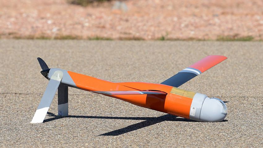
NOAA Predicts Another Active Atlantic Hurricane Season
“Although NOAA scientists don’t expect
this season to be as busy as last year, it NOAA’s 2021 Atlantic Hurricane Seasonal Outlook
only takes one storm to devastate a
community. The forecasters at the Named Storms
National Hurricane Center are well- 13-20 Above
prepared with significant upgrades to ............................... normal
our computer models, emerging Hurricanes 60% 30% Below
6-10 normal
observation techniques, and the
expertise to deliver the life-saving
................................ Near
forecasts we all depend on during this, Major Hurricanes 10% normal
3-5
and every, hurricane season.”
Ben Friedman Seasonal Probability
Acting NOAA Administrator
NOAA’s Climate Prediction Center is La Niña later in the hurricane season. This hurricane season, AOML will
calling for another above-normal Atlantic “ENSO-neutral and La Niña support the deploy its largest array of air and water
hurricane season. Forecasters predict a conditions associated with the ongoing uncrewed systems to gather data designed
60% chance of an above-normal season, a high tropical cyclone activity era,” said to improve hurricane intensity forecasts
30% chance of a near-normal season, and Matthew Rosencrans, the lead seasonal and forecast models. New drones will be
a 10% chance of a below-normal season. hurricane forecaster at NOAA’s Climate launched from NOAA’s Hurricane Hunter
However, the historic level of storm Prediction Center. “Predicted warmer-than- aircraft that will fly into the lowest levels
activity seen in 2020 is not anticipated. average sea surface temperatures in the of the hurricane environment, a turbulent
For 2021, a likely range of 13–20 tropical Atlantic Ocean and Caribbean region known as the boundary layer. In the
named storms (39 mph winds or h igher), Sea, weaker tropical Atlantic trade winds, ocean, saildrones, hurricane underwater
are predicted to form, of which 6–10 could and an enhanced west African monsoon gliders, global drifters, and ALAMO floats,
become hurricanes (74 mph winds or will likely be factors in this year’s overall an air-deployable technology, will track
higher), including 3–5 major hurricanes activity.” various parts of the life cycle of tropical
(categories 3, 4 or 5; with 111 mph winds Scientists at NOAA also continue to systems.
or higher). NOAA provides these ranges study how climate change is impacting the Last year’s record-breaking season
with a 70% confidence level. The Atlantic strength and frequency of tropical c yclones. serves as a reminder to all residents in
hurricane season stretches from June 1 In an effort to continuously enhance hurri- coastal regions or areas prone to inland
through November 30. cane forecasting, NOAA has made several flooding from rainfall to monitor the
NOAA recently updated the statistics updates to products and services that will tropics, examine preparedness plans, and
that are used to determine when hurricane improve hurricane forecasting during the be ready to activate those plans if needed.
seasons are above-, near-, or below-average 2021 season. “With hurricane season starting on June 1,
relative to the latest climate record. Based In March, NOAA upgraded its flagship now is the time to get ready to advance
on this update, an average hurricane Global Forecast System (GFS) to improve disaster resilience in our communities,”
season now produces 14 named storms, of hurricane genesis forecasting. It coupled said FEMA Administrator Deanne Criswell.
which 7 become hurricanes, including 3 the GFS with a wave model that extends “Visit Ready.gov and Listo.gov to learn
major hurricanes. ocean wave forecasts from 10 days to 16 and take the steps to prepare yourself and
El Niño-Southern Oscillation (ENSO) days. Global Positioning Satellite Radio others in your household.”
conditions are currently in the neutral Occultation (GPS-RO) data are also now The Atlantic hurricane outlooks are
phase, with the possibility of the return of included in the GFS model, providing an an official product of NOAA’s Climate
additional source of observations to Prediction Center, produced in collabora-
strengthen its overall model performance. tion with the National Hurricane Center
2021 Atlantic Storm Names Forecasters at the National Hurricane and AOML.
Ana Henri Odette Center are now using an upgraded proba- NOAA will provide an update to its
bilistic storm surge model, known as Atlantic outlook in early August, just prior
Bill Ida Peter
P-Surge, that includes improved tropical to the peak of the season.
Claudette Julian Rose cyclone wind structure and storm size
Danny Kate Sam information that offers better predictability
Elsa Larry Teresa and accuracy. This upgrade extends the This article is modified from a
Fred Mindy Victor lead time of P-Surge forecast guidance May 20, 2021 web story on
Grace Nicholas Wanda from 48 to 60 hours in situations where
www.noaa.gov
there is high confidence.
April-June 2021 AOML Keynotes | 5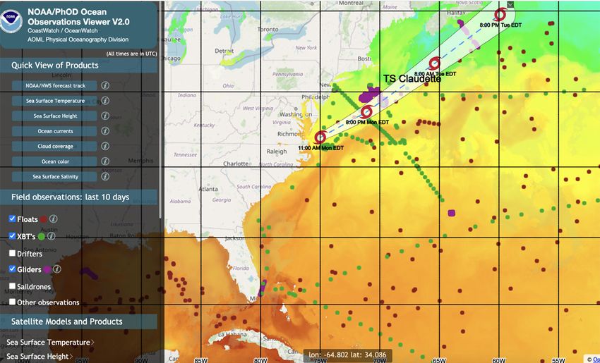
AOML to Use Ship of Opportunity Data in Support of Extreme Weather Forecasts
and Sea Level S
tudies
In June, AOML began a new collabora-
tion with ships of opportunity to collect
temperature profiles along the U S Atlantic
continental shelf from New York to Florida.
Expendable bathythermographs or XBTs,
probes that measure heat in the upper
ocean, will be deployed by the crews of
cargo vessels at a spatial distance of
approximately 130 km following estab-
lished logistics for regularly sampled XBT
transects.
The ships currently contributing to this
effort include the Hapag Lloyd vessels
Chicago Express and Bremen Express. In
July, the Maersk Vilnius and Maersk Visby
will also join the effort, currently used to
obtain XBT data along the AX07 (Miami
to Gibraltar) and AX08 (Cape Town to
New York) transects, respectively.
XBT data are transmitted in real-time to Map of the Atlantic basin with the location of XBT temperature observations (red circles) obtained by the Hapag
the Global Telecommunication System to Lloyd cargo vessel Chicago Express during its transit from New York to Florida after completing the AX07 XBT
provide temperature observations in transect (Gibraltar–New York, May-30-June 9, 2021). Background colors represent sea surface temperatures in
the Atlantic on June 8, 2021. Green circles show the location of Argo float observations, while blue circles show
regions known to contribute to hurricane the location hurricane glider observations. The panel insert depicts an XBT temperature profile obtained off the
intensity changes and where ocean water coast of Georgia. The source of this image is the AOML-Physical Oceaonography Division’s Ocean Observations
mass properties contribute to sea level Viewer: https://cwcgom.aoml.noaa.gov/cgom/OceanViewer/index_phod.html.
changes. These observations are assimi-
lated into NOAA’s operational ocean also complement Argo float measure- e astern seaboard. These deployments can
models to better characterize the upper ments, which provide a broader scale of be tracked online by visiting the Ocean
ocean’s thermal structure in shelf waters sampling but often miss boundary c urrents, Observations Viewer web page of the
that are normally undersampled. as well as hurricane gliders, whose Physical Oceanography Division (see blue
Similar to data from other observing sampling is geared toward obtaining
link in the c aption above).
platforms, these XBT data will be evaluated observations with high horizontal spatial AOML’s ship of opportunity XBT
for their impact to better represent ocean resolution along fixed tracks. network is funded by NOAA’s Global
water mass properties linked to hurricane Approximately 700 XBTs are expected Ocean Monitoring and Observing Program
weakening or intensification. They will to be deployed annually along the US and AOML.
Ocean Observations Collected Ahead of T ropical
Storm Claudette
In June, Tropical Storm Claudette passed directly over areas
in the Atlantic Ocean that were being surveyed by three ocean
observing platforms: hurricane gliders, Argo floats, and
expendable bathythermographs (XBTs). The forecasted track
of Claudette is superimposed on the map to the right, showing
how these observing platforms measured ocean water mass
properties off the US northeast coast and across the Gulf
Stream ahead of Claudette’s projected path. The use of
multiple observing platforms that collect targeted and
sustained ocean observations enable the ocean’s thermal
structure to be more accurately characterized in ocean and Map showing sea surface conditions in the Atlantic Ocean on June 21, 2021, the projected
path of Tropical Storm Claudette, and the location of in-situ observations that generate
hurricane forecast models. Data from these three platforms
temperature profiles: Argo floats (dark red), XBTs (green), and hurricane gliders (purple).
were assimilated into the Real-Time Ocean Forecast System at
NOAA’s Environmental Modeling Center. They demonstrate how different components of the observing system all contribute key upper ocean
profile data to better represent the ocean during extreme weather events.
6 | AOML Keynotes April-June 2021
Heat Tolerant Corals May Be the Key to Improving Restoration Efforts
A new study* by researchers at the
niversity of Miami’s Rosenstiel School
U (a) (b)
of Marine and Atmospheric Science and
AOML suggests that outplanting corals,
specifically staghorn coral (Acropora
cervicornis) from higher temperature
waters to cooler waters, may be a better
strategy to help corals recover from certain
stressors. The researchers found that
corals from reefs with higher average
water temperatures showed g
reater
healing than corals from cooler waters
when exposed to heat stress.
Researchers collected 18 coral g enotypes
from the University of Miami’s coral
nursery that were originally sourced from
different reefs along Florida’s east coast
(image at right) and monitored them for
recovery after exposure to heat stress.
They found that corals exposed to increas-
ingly warm temperatures did not heal as
successfully as those corals that were kept (a) Key Biscayne nursery and donor reef locations. Colored circles correspond with donor reef 4-km resolution
at a constant temperature, but that being maximum monthly mean (MMM) sea surface temperature data in which red circles indicate an MMM>29.9°C
and blue circles indicate an MMM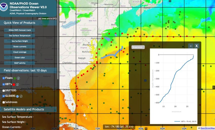
AOML Scientist Collects eDNA to Make Connections in Marine Food Webs
Nastassia Patin, PhD, a University of The eDNA will additionally be analyzed
Miami-Cooperative Institute scientist at for information on microbial genomes and
AOML, spent 3 weeks in May aboard the biochemical function, which are not
NOAA ship Reuben Lasker collecting attained through metabarcoding. “Marine
environmental DNA or eDNA from water eDNA research has lagged behind that of
samples in support of the Rockfish terrestrial and aquatic environments,” said
Recruitment and Ecosystem Assessment Dr. Patin, “largely due to challenges with
Survey. field sampling and sequence data
In collaboration with scientists from the analysis.”
National Marine Fisheries Service, Dr. As part of NOAA’s efforts to develop
Patin collected 339 samples at transect eDNA methods, Dr. Patin worked to
stations along the coast of C alifornia from optimize sampling protocols aboard the
Point Reyes to San Diego. Reuben Lasker, a challenging project
Environmental DNA refers to DNA considering the ship was not designed for
collected directly from habitats like soil, sensitive molecular work. Advancements
freshwater, or the ocean. It contains the in eDNA sampling and analysis methods
DNA of organisms that live in or have will improve the detection of rare, inva-
passed through that habitat, including sive, and endangered species that may not
rare, invasive, and e ndangered species. be comprehensively assessed with visual
The eDNA gathered during the survey surveys.
will be used for marker gene sequencing, According to Dr. Patin, “expanding
i.e., “metabarcoding,” for organisms at macrofaunal assessments beyond visual
different trophic levels from microbes to surveys will provide more precise infor-
whales. Trophic level refers to the position mation on areas of predator/prey overlap Nastassia Patin aboard the NOAA Ship Reuben
Lasker assembles a filter to capture eDNA from
of an organism in a food chain, based on than is currently possible with visual a water sample.
the amount of consumption steps that surveys. Further, linking multiple trophic
separates it from the original energy
levels will contribute to our understanding analyzed with trawl catch information,
source, such as the sun. Interactions of coastal marine food webs, whose foun- along with other ecological metrics, to
between organisms in different trophic dation is microbial and the highest levels provide a better understanding of marine
levels cause the energy flow to be more of which include blue whales.” food webs, organism interconnectivity in
complex than a linear chain (food chain), Environmental DNA data generated the California Current, and predator/prey
and is better r epresented as a food web. from the survey will be sequenced and coexistence in these areas.
Experimental Mapping Tool Shows
Potential for Improving Restoration
Efforts for Coral Reefs
To help improve the long-term survival
of nursery-raised staghorn coral (Acropora
cervicornis), Ruben van Hooidonk, a
University of Miami-Cooperative Institute
coral scientist at AOML, has developed an
experimental mapping tool that ranks
suitable outplant locations. There are
currently at least seven coral nurseries in
Florida that cultivate staghorn coral,
representing the best opportunity to
maintain resilient populations of this
species. Screenshot of a new mapping tool that shows the outplanting score for corals in the vicinity of
Key Largo, Florida.
The tool ranks candidate outplanting
sites based on binary (yes/no) and
continues criteria. The binary criteria include Acropora critical habitat, depth, coral hard bottom, and turbidity, while continues criteria consider the
relative resilience of the location and the projected climate change impact, i.e., the year of onset for annual severe bleaching conditions. “Raising
and outplanting corals can cost millions of dollars,” according to van Hooidonk. “This tool is designed to help guide outplanting strategies for
nursery-raised staghorn coral to maximize their long-term survival, which could, in turn, increase the effectiveness of the nurseries and promote the
presence of staghorn coral along the Florida reef tract.”
8 | AOML Keynotes April-June 2021
Coral Growth in Flower Garden Banks Approaches Threshold as Sea Temperatures Rise
A recent study* by scientists at AOML
and the Cooperative Institute for Marine
and Atmospheric Studies shows that the
growth observed in two coral species,
symmetrical brain corals (Pseudodiploria
strigosa) and mountainous star corals
(Orbicella faveolata), in the Gulf of
Mexico’s Flower Garden Banks National
Marine Sanctuary is linked to warming
sea surface temperatures.
Coral reefs in many areas of the world
are declining, with the western Atlantic
showing some of the greatest losses.
Despite this trend, coral coverage for the
high latitude, remote reefs in Flower
Garden Banks has remained at 50% or
greater since 1989. Based on data collected
by NOAA’s National Coral Reef Monitoring
Program, Flower Garden Banks is the
only Atlantic coral reef site under US
jurisdiction to be scored as being in
“good” c ondition. Brain corals in the Gulf of Mexico’s Flower Garden Banks National Marine Sanctuary.
“Coral reef ecosystems in the Flower
Garden Banks are outliers because the top e nvironment, such as sea temperature and/ health of coral reef ecosystems in this
of the reef cap starts at 17 m and continues or river d ischarge. area.
down to 50 m,” said Nicole Besemer, a The study found that coral extension “The observed increase in coral growth
coral researcher at AOML. “These deeper and calcification for both species have is not expected to continue, as sea
corals don’t often experience the warm increased over the past 4-5 decades, temperatures have now warmed to where
temperatures that the majority of shallow providing evidence that some high latitude, the upper thermal limits for the corals at
Caribbean corals are exposed to. The cooler reef sites may experience enhanced Flower Garden Banks are being exceeded
increased temperatures at these deeper
coral growth due to ocean warming. and coral bleaching events are occurring
sites actually assist coral growth where However, while the warming ocean more frequently,” said Derek Manzello,
they might have caused bleaching at a may promote growth in some corals, over PhD, lead author of the study and the
shallow reef site.” time rising temperatures may lead to more coordinator for NOAA’s Coral Reef Watch
Scientists obtained coral cores from frequent and harmful coral bleaching
program.
symmetrical brain corals and mountainous events. Notably, the reefs in Flower Cooler water, the lack of land-based
star corals and analyzed their growth Garden Banks experienced the most pollution sources, and greater depths are
record, coral calcification, and skeletal severe bleaching event ever recorded in all factors that have enabled Flower Garden
density for the past 45-57 years (see image 2016. This indicates the region may be Banks reefs to retain their coral coverage
below). These measurements were used to approaching a warming threshold that, if compared to other regions that are more
determine whether any trends over time crossed, could likely have detrimental directly impacted by human activity,
showed a connection to changes in the consequences for the growth and overall storm damage, changes in water tempera-
ture and salinity, and coral bleaching.
Understanding how coral reefs at high
latitudes and cooler temperatures respond
to changes in the environment over time
may help scientists better predict how
these reef-building coral species will fare
when exposed to warming sea surface
temperatures and the imminent threat of
coral bleaching.
*Manzello, D.P., G. Kolodziej, A. Kirkland, N.
Besemer, and I.C. Enochs, 2021: Increasing
coral calcification in Orbicella faveolata and
Pseudodiploria strigosa at Flower Garden
Photos of coral colonies at east Flower Garden Banks, along with computerized tomography (CT) images of Banks, Gulf of Mexico. Coral Reefs, 40(4):
cores, for (a,b) brain coral and (c,d) mountainous star coral. The CT images illustrate clear annual banding, 1097-1111, https://doi.org/10.1007/s00338-
showing their growth over time. 021-02108-8.
April-June 2021 AOML Keynotes | 9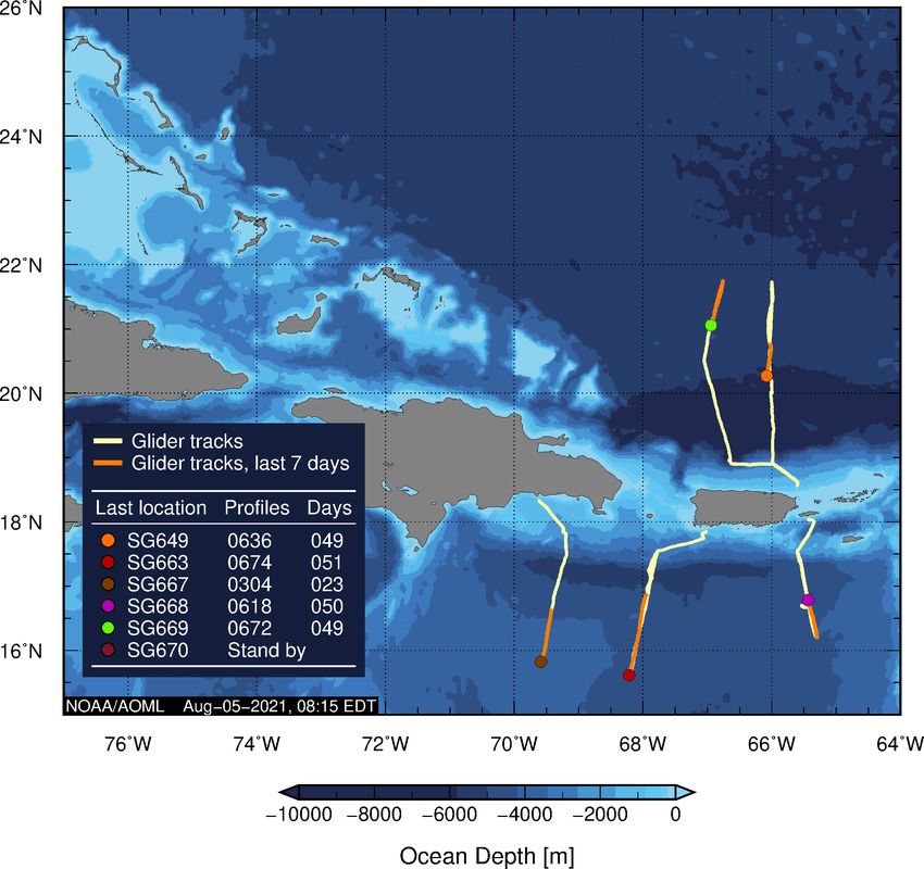
New Tool Tracks Sargassum Inundation Potential for Coastal Communities
A recently published paper* presents
the Sargassum Inundation Report (SIR), a
new tool that uses a satellite-based
methodology to remotely monitor areas
with coastal inundations of Sargassum.
SIR was created to quantify, predict, and
better manage Sargassum influxes, which
have major economic, social, environ-
mental, and public health impacts for
communities that border the Caribbean
Sea, tropical Atlantic Ocean, and Gulf of
Mexico.
Sargassum is a type of floating brown
alga commonly called “seaweed.” These
alga float at the sea surface, where they
often aggregate to form large mats on the
open ocean. Historically, Sargassum was
found within the Gulf of Mexico and
western North Atlantic, with the majority
of it aggregating in the Sargasso Sea. In
2011 its geographic range expanded, and
massive quantities of Sargassum began
washing ashore along islands throughout
the Caribbean Sea.
The study presents the results of an
analysis carried out with SIRs; the fields
presented in these reports show promise
as a platform that can incorporate new
data sources and integrate them with
forecast models as they develop. These
fields also provide a long-term time series
to identify trends and variability, detect
extreme events, and facilitate cross-
validation with other datasets.
SIR is made up of weekly fields derived
(A) SIR for July 2–8, 2019 indicating a high (red) Sargassum inundation potential for Cancun, and (B) a photo
from satellite-based observations that esti- showing severe coastal inundation of Sargassum in Cancun, Quintana Roo, Mexico on July 12, 2019 (Source:
mate the abundance of Sargassum in the Isaac Esquivel/Cuartooscuro.com). (C) SIR for July 7–13, 2020 indicating a medium (orange) inundation potential
open ocean and forecast its potential to for Miami, Florida, and (D) a photo showing moderate levels of Sargassum along the beach in Miami on July
8, 2020 (Source: Marine Macroalgae Research Lab–Florida International University). SIRs can be accessed at
reach coastlines for five regions: the Gulf https://www.aoml.noaa.gov/phod/sargassum_inundation_report/index.php?dtrange=SIR_20210726.
of Mexico, Central America, the Greater
Antilles, the Lesser Antilles, and South estimates are analyzed for a radius of ational Environmental Satellite, Data, and
N
America. This product provides informa- 50 km from the coastline; the inundation Information Service (NESDIS), NOAA’s
tion about the presence of Sargassum potential is then categorized into three CoastWatch Program, the University of
within the vicinity of coastlines, although levels: low, medium, and high. Coastlines South Florida, University of Miami, and
other coastal processes, such as winds, are color coded according to the potential LGL Ecological Research Associates, Inc.
waves, and currents, ultimately determine for Sargassum reaching the coast It is anticipated SIR reports will be
how much Sargassum washes ashore. In addition to satellite observations, produced daily and distributed by N ESDIS
The SIR algorithm uses 7-day Floating in‑situ observations in the form of images and NOAA’s National Ocean Service in
Algae density fields to estimate the and descriptions are being added to an support of regional efforts to monitor
potential for Sargassum to wash ashore. in-house database. The availability of Sargassum extreme events and their
These satellite-derived Sargassum density satellite-derived Sargassum estimates and impact on coastal regions and regional
fields of coastal inundation potential that economies.
can be combined with other data types The research also supports the AtlantOS
*Trinanes J., N.F. Putman, G. Goni, C. Hu, and M. also provides the o pportunity for machine program’s efforts to foster cooperation,
Wang, 2021: Monitoring pelagic Sargassum learning algorithms to automatically detect align interests, and implement an i ntegrated
inundation potential for coastal communities. and quantify the amount of Sargassum all-Atlantic Ocean observing and informa-
Journal of Operational Oceanography, from webcams and photographs. tion system that will link a number of
https://doi.org/10.1080/1755876X.2021. This work is a collaborative research existing and future ocean observing activities
1902682. effort between scientists at AOML, NOAA’s to meet user needs.
10 | AOML Keynotes April-June 2021Scientists at AOML Develop First-ever Daily Estimates of Heat Transport in the
South Atlantic Ocean
In a study published recently in the
J ournal of Geophysical Research-Oceans,*
scientists at AOML, the Cooperative Insti-
tute for Marine and Atmospheric Studies,
and abroad used data from moored instru-
ments to produce a daily, continuous time
series of the volume and heat transports in
the South Atlantic along 34.5°S. This is
the first time data from a moored array
have been analyzed to create a full-depth,
daily heat transport time series at this key
location for inter-ocean e xchange.
Flow patterns in the South Atlantic are
thought to control the stability of the e ntire
meridional overturning circulation (MOC),
a component of the global ocean circula-
tion that plays a major role in redistributing
heat, salt, dissolved oxygen, and carbon.
Variations of the MOC, particularly the
transport of heat, have important societal
impacts on coastal sea levels, marine heat
waves, extreme weather events, and shifts
in regional surface temperature and
precipitation patterns, all of which impact
human resources (i.e., agriculture, fisheries,
infrastructure, and more), as well as health
around the globe.
The southern end of the South Atlantic
Ocean serves as the gateway for water
masses formed in the Pacific, Indian, and
Southern oceans to exchange, mix, and
flow into the Atlantic Ocean. Due to the (a) SAMBA mooring locations used in this study (green squares) and mean meridional heat transport in
difficulty in observing the MOC and its the South Atlantic. (b) Temporal variability of the total meridional heat transport at 34.5°S.
heat transport, however, many questions
remain about these key oceanic flows.
“The South Atlantic plays a unique role and interannual changes of these important The new dataset is valuable for
in the overturning circulation, as the only oceanic flows with strong variations on v alidating and improving ocean and
basin transporting heat towards the time scales of a few days to a few weeks. climate models, both at NOAA and around
equator and connecting the North Atlantic For example, during this 4-year period the the globe. These improved models will
to the other oceans basins,” said Marion amount of heat transported northward was enable scientists to make more accurate
Kersalé, a Cooperative Institute scientist several times its mean value on multiple forecasts of Earth’s changing climate.
at AOML and lead author of the study. occasions. These observations also showed This research supports the vision of
The research team used a dataset from that volume and heat transports varied in a the AtlantOS Program to deliver an
an array of moored sensors across the consistent manner with one another. advanced framework for the development
Atlantic along 34.5°S—the South Atlantic “This allowed us to use earlier moored of an integrated Atlantic Ocean observing
MOC Basin-wide Array or SAMBA—to observations from a pilot version of the system.
develop a new technique for estimating SAMBA array, extending the record
full-depth temperature profiles. Because farther back in time and producing
these instruments are widely-spaced and ~6 years of daily estimates of heat *Kersalé, M., C.S. Meinen, R.C. Perez, A.R.
therefore miss key details of the interior transport,” said Renellys Perez, an AOML Piola, S. Speich, E.J.D. Campos, S.L. Garzoli, I.
heat structure of the MOC, satellite, CTD oceanographer. “To do so, MOC volume Ansorge, D.L. Volkov, M. Le Hénaff, S. Dong, T.
(conductivity-temperature-depth), and Argo transport was used as a proxy for heat Lamont, O.T. Sato, and M. van den Berg, 2021:
profiling float observations were used to transport. Going forward, we can use the Multi-year estimates of daily heat transport
fill data gaps. MOC volume transport to estimate heat by the Atlantic Meridional Overturning
This technique produced ~4 years of transport operationally until a more d etailed Circulation at 34.5°S. Journal of Geophysical
daily estimates of heat transport in the and accurate heat transport calculation can Research–Oceans, 126(5):e2020JC016947,
South Atlantic Ocean, revealing seasonal be made.” https://doi.org/10.1029/2020JC016947.
April-June 2021 AOML Keynotes | 11AOML Welcomes Summer Interns...Virtually!
AOML welcomed a small but talented group of summer interns to its ranks in June. Guided by seasoned career professionals, they began
tackling a variety of research projects in support of the lab’s three science divisions. It is hoped the skills and relationships they develop, as
well as their acquaintance with NOAA, will better prepare them for future educational and career opportunities.
“It has been amazing meeting scientists from a variety of backgrounds and experiences, and especially learning about NOAA as an organization.”
Shelby Gibson
Erica Bower is a third year PhD student Nicole Luchau is an undergraduate student
a ttending Stony Brook University as an ( rising junior) at New York University majoring is
atmospheric science major. She joined AOML’s environmental studies and public policy. She
Physical Oceanography Division as a NOAA- joined AOML’s Ocean Chemistry and Ecosystems
William M. Lapenta intern to work with Drs. Division to work with Drs. Sean Anderson and
Hyun-Sook Kim and Matthieu Le Hénaff. Erica’s Luke Thompson. Nicole is helping to process
research project is focused on the effects of hurri- environmental DNA (eDNA) samples collected
canes Laura and Marco (2020) on the upper ocean environment in from the Rosenstiel School dock using the Submersible Automated
the Gulf of Mexico. She is studying barrier layer formation, Sampler. Her project involves learning the latest bioinformatics
maintenance, and destruction due to the passage of Laura and tools (QIIME 2 and Tourmaline), analyzing eDNA data using the
Marco’s wind and precipitation fields. She will also compare the coding software R, and developing interactive visualizations to
representation of these p rocesses in the NCODA dataset with the better inform eDNA results.
HWRF-POM and HYCOM hurricane models.
Nicholas Mesa is an undergraduate student
Shelby Gibson is an undergraduate student (rising junior) at the University of Florida
(senior) at the University of California-Berkeley majoring in civil engineering. He joined AOML’s
majoring in geophysics and marine science. She Hurricane Research Division as a NOAA-William
joined AOML’s Physical Oceanography Division P. Lapenta intern to work with Drs. Jonathan
as a NOAA-Ernest F. Hollings Scholar to work Zawislak and Robert Rogers. Nicholas is
with Dr. Sang-Ki Lee. Shelby is quantifying and analyzing near-coincident satellite and aircraft
analyzing marine heatwave and cold-spell events observations to develop diagnostics for assessing the distribution
off the US Gulf coast during 1982-2020. Using statistical methods, of precipitation around storms and the relationship of that distribu-
she is exploring the relationships between these anomalous events tion to the humidity in the environment and near-environment of
with other key climate modes of variability such as the El Niño- the tropical cyclone.
Southern Oscillation, North Atlantic Oscillation, North Atlantic
tripole, and P
acific-North American teleconnection patterns. Michelle Spencer is a graduate student at the
University of Wisconsin-Milwaukee soon to be
Sophie Grimsley is an undergraduate student at entering her last semester before obtaining an MS
the University of South Carolina Honors College, degree in atmospheric sciences. She joined
majoring in environmental science. Sophie joined AOML’s Physical Oceanography Division as a
AOML’s Hurricane Research Division as a NOAA- NOAA-William P. Lapenta intern to work with
William P. Lapenta intern to work with Drs. Jun Drs. Renellys Perez and Greg Foltz. Michelle is
Zhang and Frank Marks. She is researching the using in-situ data collected from moorings in the North Atlantic
relationship between boundary layer structures Ocean, via the PIRATA project, to study the effects of tropical
and intensity change in hurricanes by analyzing dropsonde and tail cyclones on the upper ocean. Her goals are to determine the p rimary
Doppler radar data. Using Hurricane Irene (2011) as a case study, storm factor(s) controlling surface and subsurface temperature,
Sophie is examining the height of the boundary layer, its recovery, salinity, and velocity responses to tropical cyclones by analyzing
and linkage to convective structure. nine storms that passed within two degrees of the mooring sites.
AOML Senior Scientist Contributes to UNESCO Report
“This integrated ocean carbon research (IOC-R) report emphasizes the need for research to meet three key
challenges of the UN Ocean Decade: unlocking ocean-based solutions to climate change, expanding the global
ocean observing system, and delivering data, knowledge, and technology to all.”
Rik Wanninkhof, AOML Senior Scientist and lead editor for the IOC-R Report
In April, the United Nations Educational, Scientific and Cultural Organization’s (UNESCO) Intergovernmental
Oceanographic Commission published a report highlighting the ocean’s critical role in regulating climate through
the uptake of carbon dioxide. Integrated Ocean Carbon Research: A Summary of Ocean Carbon Knowledge and
a Vision for Coordinated Ocean Carbon Research and Observations for the Next Decade presents a synthesis
of current knowledge about the ocean carbon cycle. It also provides a plan for future ocean carbon research
to help decision-makers better prepare for climate change mitigation and adaptation policies in the coming
decade. The full report can be accessed at https://unesdoc.unesco.org/ark:/48223/pf0000376708.
12 | AOML Keynotes April-June 2021AOML Hosts First
Virtual Open House
AOML hosted its first virtual open
house in April in celebration of
Earth Day with a series of hour-long
webinars that aired nightly from
Tuesday, April 20, to Friday, April 23.
The week-long event showcased
presenters from AOML’s three
science divisions – Physical
Oceanography, Hurricane Research,
and Ocean Chemistry and
Ecosystems – who spoke about
their recent research and answered
questions from the audience.
Eyes on our Ocean focused on how
the ocean changes over time and
some of the instruments scientists
use to monitor these changes, the
ocean’s role in extreme weather
events, and how natural and human
activities impact marine resources.
Hunting Hurricanes explored what
it’s like to fly into the eye of the
storm, some of the new technology
scientists at AOML are using to
better understand the workings of
tropical cyclones, and how to be
better prepared for hurricane
season.
Coasts and Corals examined a few If you missed AOML’s Virtual Open House, no worries! The
of the stressors that challenge the
health of coral reefs and other
fyi webinars were recorded. Videos of the four virtual sessions
can be viewed by clicking on the following links:
marine ecosystems, pathogens that
cause disease and harmful algal
blooms, and molecular methods Eyes on our Ocean
being used to genetically identify a https://www.youtube.com/watch?v=mhEGqxjPbVo
wide range of marine organisms. (featuring Rick Lumpkin, Renellys Perez, Shenfu Dong, and Grant Rawson)
Ask AOML Q&A enabled audience
members to listen in on a lively Hunting Hurricanes
panel discussion that featured a https://www.youtube.com/watch?v=K-Sdz-Ajscs
hurricane scientist, coral researcher, (featuring Jon Zawislak, Rob Rogers, Joe Cione, and Shirley Murillo)
IT specialist, oceanographer, and a
technical engineer. These panelists
answered questions from the
Coasts and Corals
audience and spoke about their https://www.youtube.com/watch?v=sVIx9SkK33M
backgrounds, education, career (featuring Chris Kelble, Nicole Besemer, Anderson Mayfield, and Nastassia Patin)
paths, and working for NOAA.
AOML’s virtual open house was Ask AOML Q&A
organized and hosted by Heidi Van https://www.youtube.com/watch?v=nYEYkAoLbnc
Buskirk, an AOML communications (featuring Evan Forde, Alejandra Lorenzo, Michael Studivan, Heather Holbach,
specialist, with assistance from the and Diego Ugaz)
AOML Comms Team.
April-June 2021 AOML Keynotes | 13Congratulations
Leticia Barbero, a Cooperative Institute s cientists in similar fields of study, such as biology, chemistry, or
scientist with AOML’s Ocean Chemistry and physics; and (3) how often those papers are referenced in the lay
Ecosystems Division, was selected in May to press, social media, policy papers, and other outlets.
become the new Co-Chair for the Global Ocean
Ship-based Hydrographic Investigations Program Ramon Hurlockdick, an information technology
(GO-SHIP). AOML participates in GO-SHIP as specialist with AOML’s Office of the Director,
part of an international effort to study decadal recently earned a PhD in Information Systems
changes in ocean carbon, acidification, and stratification. As the from the College of Computing and Engineering
GO-SHIP Co-Chair, Leticia will work to align NOAA’s priorities at Nova Southeastern University. His thesis, “How
with other international stakeholders and partner programs. She non-compliance impacts security incidences: A
succeeds AOML senior scientist Rik Wanninkhof in the position, public sector case study of application security
who served as the Go-SHIP Co-Chair for the past 6 years. and proper data governance,” explored the critical role of training
in preparing staff responsible for implementing security policies
Nicole Besemer, a Cooperative Institute scientist,
and procedures. Ramon began his doctoral studies at Nova
and Ian Enochs, a research ecologist, both with
Southeastern University, designated a center of excellence by the
AOML’s Ocean Chemistry and Ecosystems
National Security Agency, through the support of the Graduate
Division, are members of the Working Group for
Studies Program of NOAA’s Office of Oceanic and Atmospheric
NOAA’s Coral Reef Condition Status Reports, that
Research.
received a 2021 Hermes Creative Platinum Award
in May for Outstanding TV Placements and Rayne Sabatello, a Cooperative Institute
Outstanding Overall Publicity Campaign. The c ommunications intern with AOML’s Physical
group received the award from the International Oceanography Division, earned a Master of
Association of
Marketing and Communication Professional Science degree in Climate and
Professionals in recognition of compelling print Society from the University of Miami’s Rosenstiel
media exposure created during a pandemic through School in May. Rayne’s thesis, Improving commu-
virtual press events. nications quality for the Physical Oceanography
Joseph Bishop, a mechanical engineer with Division at NOAA’s Atlantic Oceanographic and Meteorological
OML’s Ocean Chemistry and Ecosystems
A Laboratory, aimed to enhance the division’s communications
Division, was named NOAA’s Employee of the through the creation and use of five communication mediums—
Month for April 2021. Joe was recognized for his web pages, news stories, social media posts, field journals, and
leadership in designing, engineering, and d eploying two-page flyers. The project determined the benefits of each
a first-of-its-kind real-time monitoring buoy at communication tool and its effectiveness in reaching AOML’s
Port Everglades in Fort Lauderdale, Florida. The diverse target audiences. The results will assist AOML in
buoy is part of an expert system that will assess oceanographic developing the lab’s FY-2022 communications strategy.
conditions to protect coral reefs and other marine life during a
Luke Thompson, a Cooperative Institute
major expansion project at the port in 2022. Due to Joe’s efforts,
b ioinformatician with AOML’s Ocean Chemistry
the buoy is fully functioning and ready to support both dredging
and Ecosystems Division, accepted an invitation
operations and coastal ecosystems.
in April to serve as a member of the Scientific
Michael Fischer, a Cooperative Institute scientist Committee for the Earth HoloGenome Initiative
with AOML’s Hurricane Research Division, was (EHI). The EHI, based at the Centre for
awarded a 2020 Reviewer’s Certificate by the Evolutionary Hologenomics at the University of
Royal Meteorological Society in June. Michael Copenhagen in Denmark, is building a collaborative network to
received the award in recognition of the quality generate a standardized collection of fecal/cloacal swabs and tissue
and thoroughness of a large number of reviews he samples of wild vertebrates across the globe. The initiative aims to
completed on tropical cyclone analyses for the study eco-evolutionary questions related to the spatial, temporal,
Quarterly Journal of the Royal Meteorological Society. By and phylogenetic patterns of wild animal–microbiota interactions.
bringing his expertise in observations and modeling to the review
process, Michael enabled the Royal Meteorological Society to Jonathan Zawislak, a Cooperative Institute
uphold its high standards for papers published in its journals. s cientist with AOML’s Hurricane Research Division,
accepted an invitation in April from the American
Gregory Foltz, an oceanographer with AOML’s Geophysical Union to become an Associate Editor
Physical Oceanography Division, was selected in of Journal of Geophysical Research-Atmospheres.
April as one of the world’s 1,000 most influential Jon will critically review and assess the quality of
climate scientists by Thomson Reuters, the c ompany research articles submitted to the journal with a
that provides the Web of Science database service. focus on tropical cyclones for a term of 3 years. The journal
Thomson Reuters created their international publishes research to advance and improve the understanding of
listing based on three rankings: (1) how many atmospheric properties and processes, including the interaction of
research papers scientists have published on topics related to the atmosphere with other components of the Earth system, as well
climate change; (2) how often those papers are cited by other as their roles in climate variability and change
14 | AOML Keynotes April-June 2021You can also read