Rockall and Hatton: Resolving a Super Wicked Marine Governance Problem in the High Seas of the Northeast Atlantic Ocean
←
→
Page content transcription
If your browser does not render page correctly, please read the page content below
REVIEW
                                                                                                                                          published: 27 February 2019
                                                                                                                                       doi: 10.3389/fmars.2019.00069

                                             Rockall and Hatton: Resolving a
                                             Super Wicked Marine Governance
                                             Problem in the High Seas of the
                                             Northeast Atlantic Ocean
                                             David E. Johnson 1*, Christopher Barrio Froján 1 , Francis Neat 2 , Dick Van Oevelen 3 ,
                                             David Stirling 4 , Matthew J. Gubbins 4 and J. Murray Roberts 5
                                             1
                                              Seascape Consultants Ltd., Romsey, United Kingdom, 2 Marine Stewardship Council, London, United Kingdom, 3 Royal
                                             Netherlands Institute for Sea Research (NIOZ), Texel, Netherlands, 4 Marine Laboratory, Marine Scotland Science, Aberdeen,
                                             United Kingdom, 5 School of Geosciences, The University of Edinburgh, Edinburgh, United Kingdom

                                             The Hatton-Rockall plateau in the northeast Atlantic Ocean has long been the subject of
                                             interest for fishers, prospectors, conservationists, managers, planners, and politicians.
                            Edited by:
                                             As a feature that straddles national and international waters, it is subject to a
                        Daniela Zeppilli,    multitude of competing and confounding regulations, making the development of a
  Institut Français de Recherche pour
                                             holistic management plan for sustainable use fraught with difficulty. Here, the various
   l’Exploitation de la Mer (IFREMER),
                                 France      stakeholders in the area are collated, together with the rules they have created or
                        Reviewed by:         must abide by with respect to biodiversity assets, maritime resources, and governance
                       Silvia Bianchelli,    frameworks. Blue Growth envisages optimal use of sea areas, including potential for
  Polytechnical University of Marche,
                                   Italy
                                             additional commercial activities. Current research and stakeholder engagement efforts
             Igor Fernández-Urruzola,        to achieve this integration are described, and the contribution of the EU-funded ATLAS
Millennium Institute of Oceanography,
                                             project is analyzed. In particular, more precise, ground-truthed information has the
      University of Concepción, Chile
                                             potential to inform systematic conservation planning, providing the basis for sustainable
                 *Correspondence:
                   David E. Johnson          development and improving adaptive management. By scrutinizing and exposing all the
                    david.johnson@           elements in this example of a spatially managed area we show how the expectations of
           seascapeconsultants.co.uk
                                             each stakeholder can be better managed.
                 Specialty section:          Keywords: Blue Growth, areas beyond national jurisdiction ABNJ, marine spatial planning MSP, ecosystem
       This article was submitted to         approach to fisheries management EAFM, ecologically or biologically significant area EBSA
Deep-Sea Environments and Ecology,
             a section of the journal
         Frontiers in Marine Science
                                             INTRODUCTION
         Received: 18 October 2018
        Accepted: 07 February 2019           Beyond 200 miles from any coastline, in oceanic areas beyond national jurisdiction (ABNJ), no
        Published: 27 February 2019          central authority holds the responsibility for controlling all of the activities that take place there
                             Citation:       (e.g., fishing, mineral extraction, shipping/communication, environmental protection). Instead, the
 Johnson DE, Barrio Froján C, Neat F,        regulation of each activity is entrusted to activity-specific stakeholders, whose objectives are not
Van Oevelen D, Stirling D, Gubbins MJ        always compatible with each other or with long-term sustainability of the ecosystem. Resolution
  and Roberts JM (2019) Rockall and
                                             of any conflict between stakeholders is rarely straightforward, and no single solution is beneficial
    Hatton: Resolving a Super Wicked
   Marine Governance Problem in the
                                             to all involved, often resulting in conflict or compromise, with unforeseen repercussions along a
   High Seas of the Northeast Atlantic       complex web of interacting forces. To further complicate matters, some ecosystems straddle ABNJ
         Ocean. Front. Mar. Sci. 6:69.       and the exclusive economic zone (EEZ) of a State or Union. As problems go, the governance of such
      doi: 10.3389/fmars.2019.00069          straddling ecosystems and the coordinated management of activities that take place within them

Frontiers in Marine Science | www.frontiersin.org                                  1                                               February 2019 | Volume 6 | Article 69
Johnson et al. Hatton-Rockall Plateau High Seas Governance
(including the enforcement of restricted activities and diverse offshore bathyal habitats with high habitat heterogeneity
prohibitions) represents a complex, dynamic, multifaceted between 200 and 3,000 m deep.
and thus, inherently wicked1 problem (Rittel and Webber, 1973). The marine climate of the Hatton–Rockall plateau is
Consequently, there is no panacea to perfect governance of ABNJ influenced predominantly by the strength of the North Atlantic
(Ringbom and Henrikson, 2017). subpolar gyre (Hátún et al., 2009). Depending on its strength,
As if the governance of ABNJ being a wicked problem wasn’t the plateau is either bathed in cold subarctic waters (strong
enough of a burden—given the enormous interdependencies, gyre) or in warmer and more saline North Atlantic waters (weak
uncertainties, circularities, and conflicting stakeholders gyre). Oscillations between the two regimes have a notable effect
implicated by any effort to improve the situation—seemingly on pelagic faunal assemblage composition and biomass on a
definable examples of discrete governance practices in ABNJ can multi-decadal time scale.
further qualify as super wicked problems because of even further There is a history of dedicated hydrographic, fishery and
exacerbating features that characterize them (Lazarus, 2009). oceanographic surveys of the area (reviewed by Davies et al.,
Super wicked problems do not have time on their side, as current 2006), but with the advent of more sophisticated seabed mapping
levels of resource exploitation are unsustainable; the longer it technologies (e.g., Evans et al., 2015) it has become even more
takes to address the problem, the harder it becomes to resolve evident that this is a dynamic and productive area of the ocean
it. In addition, those who are in the best position to address above a topographically complex seabed. The substrate consists
the problem (i.e., resource extractors and beneficiaries capable of sedimentary mud and coarse sand punctuated by exposed
of regulation) are not only those who caused it, but also those bedrock, boulders and cobbles, all of which is host to a diverse
with the least immediate incentive to act within that necessary burrowing and encrusting faunal assemblage that includes long-
shorter timeframe. Lastly, an absence thus far of an overarching lived and fragile deep-sea coral gardens and sponge aggregations
law-making institution with a jurisdictional reach and legal (Roberts et al., 2008). In places, these species aggregations can be
authority that matches the scope of the problem only hinders regarded as vulnerable marine ecosystems2 (VMEs). In addition,
any expedient regulation or resolution (Wright et al., 2019). recent research (Berndt et al., 2012) has revealed the presence
Here we set out to describe an ostensibly discrete example of large-scale geological features known as polygonal faults in
of a super wicked problem: the sustainable governance of an the basin between the banks, which result from dewatering of
ecosystem that straddles ABNJ and EEZs around the Rockall sediments at great depth. There is also evidence that this area may
and Hatton Banks in the northeast Atlantic Ocean [commonly support chemosynthetic species indicative of cold hydrocarbon
referred to as the Hatton-Rockall plateau (Yiallourides, 2018)]. In seeps (Oliver and Drewery, 2014), as well as reduced sediments
doing so, we endeavor to capture both the complementary and and bacterial communities (Neat et al., 2018). Given the expanse
the competing initiatives put forward by various stakeholders, of the feature, there is likely much more to be discovered.
authorities and interested parties, to illustrate the complexity of The Hatton–Rockall plateau has been targeted for resource
ideas and priorities held by each. By illustrating the interaction exploitation, mainly fish, for at least two centuries (Blacker,
between science, policy and stakeholder imperatives, this super 1982), although only in the latter half of the twentieth century
wicked problem is, admittedly, no closer to being solved has this gained political importance due to the feature’s potential
(attesting to the impregnability of super wickedness), but at least to confer oil, fishing, and continental shelf rights (Yiallourides,
the players and their rules, drivers, aims, and strategies can 2018). To date, there is no exploitation of oil and gas in the
be better understood, which will hopefully allow for the better area, but bottom-fishing has impacted on the local environment
management of expectations in an effort to promote a sustainable (Piñeiro and Bañon, 2001; Durán Muñoz et al., 2011). A
future for all. cumulative impact assessment encompassing all activities has not
been conducted in the region (Gianni et al., 2016). An inventory
of ecosystem goods and services around the feature to set the
BACKGROUND scene for future valuation has only recently been completed
(Foley et al., 2018).
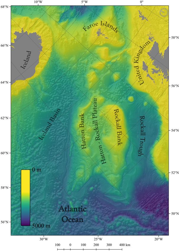
The Hatton-Rockall plateau (banks and associated slopes) is The water column overlying the feature also falls under
located midway between Greenland and Iceland to the west the remit of several international activity-regulating bodies,
and Scotland and Ireland to the east. A submerged mass such as the European Union (EU), the Convention for the
of continental crust, this seabed feature comprises two large Protection of the Marine Environment of the North-East
elevated banks, Hatton Bank to the northwest, Rockall Bank Atlantic (OSPAR Convention), the North-East Atlantic Fisheries
to the southeast. They rise from the ocean floor on either side Commission (NEAFC), the North Atlantic Salmon Conservation
(>2,000 m deep) and are separated by a shallower basin between Organization (NASCO), the International Commission for
the two (c. 1,000 m deep). The plateau, delimited by steep-sided the Conservation of Atlantic Tunas (ICCAT), the North
flanks in places, narrows as it extends north-eastwards toward Atlantic Marine Mammal Commission (NAMMCO), and the
the Faroe Islands (Figure 1), and the whole feature encompasses International Whaling Commission (IWC). Several of these
1 In this context, the term wicked does not carry connotations of evil or maleficence, 2 VMEs constitute areas containing fragile, unique, rare, long-lived, slow-growing
but instead denotes problems that are tricky, circuitous, or would appear to have a and/or structurally complex species, communities or habitats that may be
fractal dimension. vulnerable to impacts from fishing activities (FAO, 2009).
Frontiers in Marine Science | www.frontiersin.org 2 February 2019 | Volume 6 | Article 69Johnson et al. Hatton-Rockall Plateau High Seas Governance FIGURE 1 | The Hatton-Rockall plateau. organizations, either alone or in collaboration with others, have mandate, from simple recognition of a feature’s ecological identified species, features or areas worthy of protection from significance, to the prohibition or exclusion of certain activities potentially harmful activities. For example, three species of deep- from a defined area or time period. For example, under the water sharks have been identified (Centroscymnus coelolepis, EU’s Bird and Habitat Directives and the UK’s equivalent Centrophorus granulosus, and C. squamosus) that are threatened 2007 Offshore Marine Conservation (Natural Habitats, etc.) or declining in the region as a consequence of fishing activities Regulations, several seabed features around the Hatton-Rockall (CITES, 2011). All three are also on the IUCN Red List of plateau have been identified and designated as offshore marine Threatened Species. protected areas (MPAs); these include the Hatton Bank candidate Established area-based environmental protection measures Special Area of Conservation (SAC), the North West Rockall (or area-based management tools—ABMTs) vary in their Bank SAC, and the East Rockall Bank SAC. In addition, the Frontiers in Marine Science | www.frontiersin.org 3 February 2019 | Volume 6 | Article 69
Johnson et al.                                                                                                  Hatton-Rockall Plateau High Seas Governance

Hatton Rockall Basin Nature Conservation MPA has been                              et al., 2006; Henry et al., 2013) and their propagules likely provide
designated under the 2010 Marine (Scotland) Act (JNCC                              strong genetic links between Rockall and Hatton populations,
website3 ) (Figure 2). Beyond the avoidance of deterioration                       with weaker links to those in the wider region (Fox et al., 2016).
of feature condition, the precise conservation or management                           Important areas of biodiversity deserving of protection
measures that apply to each MPA can vary, although they all                        are increasingly being recognized, as predictive data (models,
fall under the broader aspiration of the EU’s Marine Strategy                      proxies, and analogs) are validated by ground-truthing surveys,
Framework Directive (EC, 2008) to achieve good environmental                       and together have enabled the production of large-scale habitat
status (GES) across European waters (ECll, 2017).                                  maps (Howell et al., 2009, 2016). The most recent surveys by
    In contrast to EC-backed MPAs, NEAFC has recommended                           Marine Scotland (600 km of transects from 150 to 1,000 m using
and enforced the closure of a number of defined areas to bottom                    towed video) have contributed to habitat mapping of Lophelia
trawling and fishing with static gear for the protection of VMEs—                  pertusa reefs, coral gardens, black corals, sea fans and whips,
the Hatton-Rockall closures—part of which are examples of                          sponge grounds, sea pen fields, and cold seeps. These sensitive
other effective conservation measures (OECMs) contributing                         benthic invertebrate species are highly susceptible to physical
to Scotland’s portfolio of MPAs (ICES, 2013a, 2014, 2015,                          damage (Hall-Spencer et al., 2002) and have lengthy recovery
2016a, 2017, 2018a). In addition, the Rockall ‘haddock box’                        times. In turn, damaged habitats and ecosystems can adversely
has been closed to fishing since 2001/2002 to protect pre-                         affect pelagic fish communities and fisheries (Armstrong and
recruitment stocks of commercially targeted haddock. To add                        Falk-Petersen, 2008).
to the complexity, part of this closure is within national waters                      Within the Hatton–Rockall plateau cold-water coral species
and under EU legislation, and the other part is in ABNJ and                        have been severely impacted by the deep-water trawl fishery
regulated by NEAFC. These fishery-imposed closures overlap in                      (Hall-Spencer et al., 2002). In future, these species are also
extent with some of the designated MPAs (Figure 2) and their                       likely to be compromised further by climate change (Roberts
enforcement is monitored closely with the aid of satellite vessel                  and Cairns, 2014; Roberts et al., 2016) and ocean acidification
tracking technology (VMS and AIS), with sanctions for deliberate                   (Perez et al., 2018). A review by Johnson et al. (2018a) considers
non-compliance. Many of the conservation measures defined by                       the expected effect of changing environmental conditions
the various regulatory bodies around the Hatton-Rockall plateau,                   under predicted climate change scenarios on taxa listed in
both within and beyond areas of national jurisdiction, are                         the conservation objectives for Rockall and Hatton VMEs. It
acknowledged and promoted by OSPAR. OSPAR also maintains                           concludes that impacts will be felt within the next 20 years at
a register of MPAs in the wider northeast Atlantic Ocean4 ,                        a rate too fast for many species to adapt to, and resilience is
and an expert group (ICG-MPA) gives annual consideration to                        already low.
candidate areas based on emerging lines of evidence.

PRESENT-DAY CONCERNS                                                               Resource Pressure
                                                                                   Studies of fishing pressure show parts of the northeast Atlantic
At face value it would appear that management and governance                       to be heavily impacted (Halpern et al., 2008; Benn et al.,
of the sea and resources around the Hatton-Rockall plateau                         2010), including, for example, areas of coral rubble and trawl
is relatively well-organized, integrated and comprehensive.                        marks on the northern Rockall Bank. The Hatton–Rockall
However, to achieve adaptive management, better integration                        plateau supports relatively shallow demersal fisheries targeting
of ecological knowledge, recognition of past mistakes (e.g.,                       haddock, gurnard and monkfish (Newton et al., 2008; Neat and
destructive fishing), new prospects and evolving management                        Campbell, 2011). Haddock has been surveyed since the 1980s,
frameworks, and changing stakeholder communities all require                       and despite volatile stock dynamics and failure to agree on an
continuous and objective re-evaluation.                                            international fishery management plan, it is currently a profitable
                                                                                   and important fishery; in 2018 it was certified as meeting the
Biodiversity Assets                                                                Marine Stewardship Council’s standard for sustainable fisheries
Benthic habitats and ecosystems (i.e., cold-water coral                            (MSC, 2018). Monkfish and megrim sole both contribute to a
formations, rocky reefs, carbonate mounds, polygonal fault                         highly valuable fishery in the area, and although heavily exploited,
systems, sponge aggregations, steep, and gentle sedimented                         data since 2005 suggest both are sustainable (ICES, 2016b). In
slopes) together with benthic and pelagic organisms (i.e.,                         the past, other important commercial species included saithe
zooplankton, fish, cetaceans, turtles, and seabirds) are of                        and cod, but these appear to have been over-exploited and
ecological significance in the area. Many such organisms and                       are no longer main target species. Deep-water bottom fisheries
ecosystems meet the criteria to feature on the IUCN Red List of                    target ling, blue ling, tusk, orange roughy, black scabbardfish,
Endangered Species and of Ecosystems. Species associations are                     roundnose grenadier and deep-water sharks (Gordon et al., 2003;
thought to be particularly important; for example, cold-water                      Large et al., 2013). The EU ban on trawling at depths > 800 m
coral formations reportedly support over 1,300 species (Roberts                    introduced in 2017 has ended these practices within the EU EEZ,
                                                                                   but deep-water fisheries in ABNJ are still being undertaken on
3 URL: http://jncc.defra.gov.uk/page-4524 (Accessed October 2018)                  the Hatton Bank. Deep-water fisheries have impacts not only
4 OSPAR MPA datasheets and access to an MPA map tool can be found at http://       on target species, which are known to be highly susceptible to
mpa.ospar.org/home_ospar/mpa_datasheets                                            over-fishing and cannot sustain fishing intensity typical of shelf

Frontiers in Marine Science | www.frontiersin.org                              4                                         February 2019 | Volume 6 | Article 69
Johnson et al. Hatton-Rockall Plateau High Seas Governance FIGURE 2 | The location of spatial management measures presently in effect at the Hatton–Rockall plateau. seas (Bailey et al., 2009), but more generally on associated deep- of the sub-polar gyre that is known to have a strong effect on blue sea fauna that also exhibit extreme longevity and slow growth whiting distribution and stock dynamics (Payne et al., 2012). rates, traits that make them vulnerable to repeated disturbance. Exploration drilling for oil and gas on the Hatton–Rockall International pelagic fisheries also target blue whiting in Hatton plateau has been considered relatively unsuccessful, although a and Rockall; here, stocks have undergone periods of concern recent reassessment of historical drilling wells in light of an due to over-exploitation, although in recent years they have been advanced understanding of the region’s geology has exposed doing well (ICES, 2018b). This is likely partly a result of reaching flaws in the original discouraging conclusions (Schofield et al., international agreements in 2006 for blue whiting between the 2017). Newly acquired seismic data, combined with a better EU, Norway, the Faroe Islands and Iceland, but may also be due understanding of results from past explorations, are leading to to variation in natural environmental cycles, such as the strength a resurgence in interest in the area by the UK’s oil and gas sector. Frontiers in Marine Science | www.frontiersin.org 5 February 2019 | Volume 6 | Article 69
Johnson et al.                                                                                                           Hatton-Rockall Plateau High Seas Governance

    Adoption by the European Commission (EC) of a Blue                                     plateau there has been early recognition of the different
Growth strategy in 2012 (Box 1) has resulted in several initiatives                        stakeholder groups and a good dialogue between the fishing
related to Europe’s oceans, seas and coasts, all intended to                               industry and government conservation agencies to assess
facilitate the cooperation between maritime business and public                            where to apply spatial management; engagement with the
authorities across borders, sectors, and stakeholders (SWD,                                fishing industry was crucial to the establishment of the first
2017). While the focus of the strategy is on five sectors                                  fishery closures. The ICES working group on deep-water
with high innovation and growth potential (see Box 1), no                                  ecology (ICES WGDEC) that provides the advice on VMEs
significant developments or pressure points on resources—                                  to NEAFC is unusual in the sense that it includes members
especially around the Hatton-Rockall plateau—appear to be close                            from environmental non-governmental organizations (NGOs).
to fruition yet.                                                                           Therefore, the process has been stakeholder inclusive from
                                                                                           the beginning.
Governance Framework
The Hatton-Rockall plateau exemplifies the complex legislative
framework that applies to many offshore transboundary                                      SPATIAL MANAGEMENT AND
situations, incorporating ABNJ, and subject to Commission on
the Limits of the Continental Shelf submissions. The need for
                                                                                           PROTECTION MEASURES
a tiered (nested), internally consistent and mutually reinforcing                          Fishery Closures
planning and decision-making system has been articulated                                   The first example of spatial management at Rockall had little
(Raakjaer et al., 2014). As noted by Freestone et al. (2014),                              to do with habitat protection. In 2001, NEAFC (and in 2002,
such situations also require agreement on overarching principles                           the EC in its waters) introduced a transboundary (ABNJ-EU)
by regional management bodies, an important element of                                     closed area for the protection of juvenile haddock in response
prospective negotiations within the BBNJ process.5                                         to concerns over declining stock levels and the increased access
    In the northeast Atlantic, OSPAR and NEAFC have signed                                 to the area by international fishing fleets (prior to 1997 Rockall
a formal memorandum of understanding (MoU; the OSPAR                                       Bank was exclusively within the EU EEZ as part of the UK).
Agreement 2008-4) and implemented a Collective Arrangement                                 Nevertheless, as this ‘haddock box’ area has remained largely
(OSPAR agreement 2014-09) (Johnson, 2013; Hoydal et al., 2014;                             closed for 17 years, it contains some important and relatively
NEAFC and OSPAR, 2015). This represents an ongoing trust-                                  untouched benthic habitats.
building exercise recognizing aspects of common purpose and                                    In the early 2000s concerns were also growing over the impact
respecting specific legal mandates.                                                        bottom trawling was having on the cold-water coral reefs known
    Despite criticisms of the global pace of implementation                                to be in the area. With the emergence of the UNGA resolutions on
of conservation efforts by regional fisheries management                                   VMEs (UNGA, 2006), RFMOs were called upon to protect areas
organizations and arrangements (RFMO/As) (e.g., Wright et al.,                             where VMEs were known or likely to occur. NEAFC contracted
2015), NEAFC is one of the leading RFMO proponents, having                                 ICES to advise on which areas were likely to contain VMEs.
closed areas to bottom fishing where there is strong evidence                              In 2005–6, ICES worked closely with the Scottish and Spanish
for the presence of VMEs (in line with UNGA resolutions) as                                fishing industries to assess where coral reefs where likely to be
part of a comprehensive High Seas fishery regime. For the past                             present. This, together with scientific survey data (from Spanish
decade NEAFC has requested that the International Council for                              and British mapping efforts), provided the basis for several
the Exploration of the Sea (ICES) provides scientific advice on                            candidate areas for protection. NEAFC closed the first areas on
the presence and distribution of VMEs within its regulatory                                the Rockall and Hatton Banks in 2007.
area and suggests spatial management approaches (e.g., fishery                                 The NEAFC closures are extensive areas that capture the main
exclusion zones/boxes around vulnerable features). VME boxes                               distribution of coral on the plateau, although at the time ICES
(also known as closed areas or closures) have been established on                          emphasized there was a high degree of uncertainty in the precise
Hatton Bank, NW Rockall, West Rockall Mounds, SW Rockall,                                  delineation of the boundaries. It is worth noting that not all
an area known as the Logachev Mounds, and in the Hatton-                                   areas proposed by ICES were acted upon by NEAFC. Where
Rockall Basin. Focus to date has been on the protection of corals                          evidence for VMEs was less certain, or there were conflicting
and the recently discovered cold-seep ecosystem, yet much of the                           reports of intensive fishing activity, such areas (e.g., East Rockall)
intensive trawling also occurs on sedimented slopes.                                       remained open to fishing. In the subsequent years, extensions
                                                                                           and modifications to the closure boundaries were made as new
Stakeholders                                                                               evidence came to light on the presence of coral reefs in the area.
Wright et al. (2019) highlight that given the status of ABNJ                               These included a large seamount to the southwest of Hatton Bank
as global commons, the challenge of identifying and consulting                             known as Edoras Bank, and an area in the Hatton-Rockall basin
relevant stakeholders is significant. For the Hatton–Rockall                               where recent scientific surveys detected the presence of a cold-
                                                                                           seep ecosystem. By 2015 all those areas where there was strong
5 TheBBNJ process refers to the recent high-level political activities in support of       evidence for VMEs had been closed to bottom fishing (Figure 2).
the development of an international legally binding instrument under the United
Nations Convention on the Law of the Sea on the conservation and sustainable use
                                                                                           It has been a predictable process in many ways, with closed areas
of marine Biological diversity of Areas Beyond National Jurisdiction (http://www.          being accepted and implemented much more quickly in areas
un.org/depts/los/biodiversity/prepcom.htm).                                                where fishing activity and corals are mutually exclusive of one

Frontiers in Marine Science | www.frontiersin.org                                      6                                          February 2019 | Volume 6 | Article 69
Johnson et al. Hatton-Rockall Plateau High Seas Governance
BOX 1 | The Blue Growth agenda.
Blue Growth has no universally recognized definition; it embodies different meanings and approaches depending on the social contexts in which it is used (Eikeset
et al., 2018). The interpretations presented here are those relevant to the stakeholders in the northeast Atlantic Ocean.
Blue Growth has its roots in the conceptualization of sustainable development, expounded over the years during four landmark international conferences: the
1972 UN Conference on sustainable development in Stockholm, the second such conference in 1992 in Rio de Janeiro, the third in Johannesburg in 2002, and
lastly, the Rio+20 UN Conference in 2012. At the Rio+20 conference, the term Green Growth was coined to encompass the concept of fostering economic growth
and development while ensuring that natural assets continue to provide the resources and environmental services on which our well-being relies. Translating this
concept of growth into the marine realm, the multifaceted economic and social importance of the ocean and inland waters was encapsulated in the term Blue
Growth. Since then, concept has been widely used and has become important in aquatic development in many nation states, regionally as well as internationally
(Eikeset et al., 2018).
According to the Organization for Economic Co-operation and Development (OECD), Green/Blue Growth is the fostering economic growth and development while
ensuring that natural assets continue to provide the resources and environmental services on which our well-being relies (UN, 2012). To the World Bank, the ‘blue
economy’ comprises the range of economic sectors and related policies that together determine whether the use of oceanic resources is sustainable. This concept
seeks to promote economic growth, social inclusion, and the preservation or improvement of livelihoods while at the same time ensuring environmental sustainability
of the oceans and coastal areas. For the Food and Agricultural Organization, Blue Growth is a cohesive approach for environmentally compatible, integrated and
socioeconomically sensitive management of aquatic resources including marine, freshwater and brackish water environments. At the global scale, Blue Growth
looks to further harness the potential of oceans, seas and coasts by promoting growth, improving conservation, building sustainable fisheries, fostering cooperation
between countries and acting as a catalyst for policy development.
For the European Commission (EC), Blue Growth is an initiative to harness the untapped potential of Europe’s oceans, seas and coasts for jobs and growth. Blue
Growth is the long-term strategy to support sustainable growth in the marine and maritime sectors as a whole (EC, 2012). It is also the maritime contribution to
achieving the goals of the Europe 2020 strategy for smart, sustainable and inclusive growth. Blue Growth is possible in a number of areas which are highlighted
within three components of the strategy: (1) sectors that have a high potential for sustainable jobs and growth, (2) components to provide knowledge, legal certainty
and security (this includes MSP to ensure efficient and sustainable management of activities at sea), and (3) sea basin strategies to foster cooperation between
countries (e.g., the Atlantic Action Plan follows the Atlantic Strategy the EC adopted in 2011). Five sectors have been identified with a high potential for Blue Growth:
aquaculture, coastal and maritime tourism (blue tourism), marine biotechnology (blue biotechnology), ocean energy (blue energy), and seabed mining. Fisheries,
offshore hydrocarbon production and transportation are not in the EC’s Blue Growth agenda (Klinger et al., 2018).
A Technical Study of MSP for Blue Growth (EC, 2018), coordinated by the EU MSP Platform, focussed on developing visions for MSP; investigating current and
future potential spatial demands for key maritime sectors and developing indicators. In many ways Blue Growth is becoming a catch-all term to express more holistic
management of complex marine social-ecological systems.
another. In areas where overlap occurs between fishing activity extend all current VME related bottom fisheries closures to
and coral, the process has been more protracted, with greater 2022, and to expand the Hatton-Rockall Basin bottom-fishing
demands for, and scrutiny of, the evidence for the existence of closure. These decisions were based on ICES advice showing
VMEs (e.g., Hall-Spencer et al., 2009). new records of VME indicator habitat (soft-bottomed deep sea
Data in the VME database for the North Atlantic—set up sponge aggregations, including a mix of Pheronema spp. and
by ICES WGDEC following FAO (2009) criteria—originally Hyalonema spp. (stalked sponges) at a depth of c. 1,200 m) (ICES,
consisted of observed occurrence records for VME indicators 2017). An additional concern noted by ICES was the temporal
(taxa or features). To ensure the advice on new data on VME disparity between AIS (vessel position) and VMS (vessel activity)
distribution is based on the best quality data, some understanding data provided to ICES, which left unresolved will undermine the
was needed on the likelihood of the occurrence of a VME confidence that can be attributed to its advice.
indicator representing an actual VME. Previously, this had been
based on expert judgement, meaning that inconsistencies could
arise. Therefore, in 2015 and 2016 the ICES WGDEC developed Marine Protected Areas
a multi-criteria tool known as the VME weighting algorithm, At the same time as VMEs were being recognized, moves were
which assigns a VME index score of High, Medium or Low afoot by States (UK and Ireland) to establish Special Areas of
likelihood of an area containing VME indicators representing a Conservation and MPAs on the Hatton-Rockall plateau and
VME. This scoring is based on two main criteria: vulnerability of contribute to the Natura 2000 network (Figure 2). However,
the indicator (based on scores against the FAO (2009) criteria for efforts to secure long-term in situ protection of biodiversity in
identification of VMEs) and taxon abundance data. Confidence ABNJ have been less successful. OSPAR has obligations to take
in the resulting score is then assigned based on four further necessary measures to protect and conserve the ecosystems and
criteria: survey method (e.g., trawl vs. ROV), number of surveys biological diversity of its maritime area, and to cooperate in the
to the area, the time range of the surveys undertaken, and the adoption of other relevant programmes and measures (OSPAR
time since the last survey. Detailed results of this application are Convention Annex V). The latter include fisheries measures for
presented in Morato et al. (2018). which OSPAR has no mandate, rather OSPAR is obliged to liaise
In 2017, the 36th Annual Meeting of NEAFC considered with relevant fisheries management authorities. Challenges and
aspects of area management including a review of NEAFC VME lessons learned have been cataloged from the OSPAR process of
closures under NEAFC Recommendation 19:2014, as amended designating the first network of MPAs in the high seas in the
by Recommendation 09:2015 (Table 1). The meeting agreed to period from 2000 to 2012 (O’Leary et al., 2012; Johnson et al.,
Frontiers in Marine Science | www.frontiersin.org 7 February 2019 | Volume 6 | Article 69Johnson et al. Hatton-Rockall Plateau High Seas Governance
TABLE 1 | Summary of the review of NEAFC VME closures (NEAFC, 2017).
Area Year closed Basis for closure New evidence on New evidence Closure Evidence for Overlap with
presence of VME on absence of encompass expanding existing fishing
VME VMEs boundaries areas
Hatton Bank 2007-2015 VME element (Bank Yes No Yes No Yes
feature) & VME indicators
Northwest Rockall 2007 VME habitats & VME Yes No Yes Yes Yes
indicators
Southwest Rockall 2008 VME habitats & VME Yes No Yes No Yes
(Empress of Britain Bank) indicators
Southwest Rockall 2013 VME indicators Yes No Yes No Yes
Logachev Mounds 2007 VME habitats & VME Yes No Yes No Yes
indicators
West Rockall Mounds 2007 VME indicators No No Yes No Yes
Hatton-Rockall Basin (cold 2015 VME habitats & VME Yes No Yes No Yes
seep) indicators
Hatton-Rockall Basin 2015 VME habitats & VME Yes No Yes Yes Yes
(sponge area) indicators
2014; Johnson, 2016). Whilst the Hatton-Rockall plateau was The EC’s Blue Growth strategy recognizes the importance
identified in 2007 by a University of York led scoping study as of marine spatial planning (MSP), and it works closely with
meeting the OSPAR MPA criteria, it was set aside as a candidate EU Member States to disseminate practical information on the
MPA in 2008 due to the political complexity of competing and implementation of MSP, sharing technical briefs, facilitating
unresolved submissions to the Commission on the Limits of the workshops to foster cooperation, and supporting the exchange of
Continental Shelf (O’Leary et al., 2012). best practices at sea-basin and EU level. An example of a current
EC-funded project to inform and refine spatial management
Other Area-Based Management Tools plans in the north Atlantic and with a specific focus on the
The outcome of a workshop convened by OSPAR and NEAFC Hatton-Rockall plateau is the ATLAS Project (Box 2).
to describe ecologically or biologically significant marine areas Janßen et al. (2017) critically examine issues associated
(EBSAs) in the Northeast Atlantic (held in Hyeres, France, with integrating fisheries into MSP. They highlight challenges
8–9 September 2011) included a proposal for an extensive including techniques to analyse where fishers fish, including
area incorporating the whole of the Hatton-Rockall plateau long-term spatial changes of commercial fish species along
approximating to the 3,000 m depth contour as a potential EBSA their successive life stages, and effects of spatial competition.
(see Appendix for the ranking of the proposed EBSA against Spatially explicit solutions for integration of fisheries into
the CBD EBSA criteria). A review of the workshop outcomes by MSP have proved elusive and the spatial resolution of ICES
ICES in March 2012 questioned the methodology and size of the statistical rectangles was deemed too coarse to reflect fisheries’
EBSAs described. By further request, in 2013 ICES reviewed the requirements for spatial information. Attempts to develop a
EBSA proposals again and came to different conclusions to the marine spatial plan for the Rockall Bank are currently underway
original workshop (rankings against EBSA criteria) and proposed as part of the ATLAS Project (Box 2; Grehan, 2018). By spatially
boundary revisions (ICES, 2013b). For Rockall and Hatton, ICES assigning monetary value of fisheries across the area based on
specified a more restricted area down to 1,500–1,800 m depth and VMS and log-book data, the economic value of the fishing
excluded the abyssal plain, citing lack of evidence of biological footprint can be evaluated and assessed in relation the ecological
or ecological significance at greater depth. For this area, the diversity and sensitivity of the area. Based on spatial overlap
ICES review only modified one ranking (against the Productivity and mutually exclusive areas where high value fisheries persist
criterion, from Medium to Low on the basis that “benthic in areas of low or average ecological diversity and sensitivity, it
secondary production in deep-water environments is generally should be possible to develop a mutually agreeable spatial plan
considered to be low compared to other environments”; ICES, that meets both fisheries and conservation priorities.
2013b). Subsequently, however, OSPAR and NEAFC Contracting
Parties have failed to agree to submit any revised results to the FUTURE CONSIDERATIONS
CBD. Johnson et al. (2018b) provide a commentary on the global
CBD EBSA process and recognize instances of evidence gaps with ICES have provided advice on, and evaluation of, fishing abrasion
an underlying ‘political’ cause. With no EBSAs listed in the CBD pressure maps based on VMS and log-book data. This mapping
EBSA Repository covering the northeast Atlantic Ocean, perhaps of spatial and temporal intensity of fishing activities with mobile
the whole region could be considered as a politically induced bottom-contacting gear and pelagic gear (excluding vesselsJohnson et al. Hatton-Rockall Plateau High Seas Governance
BOX 2 | The EU ATLAS Project contribution.
The ATLAS Project (www.eu-atlas.org) started in 2016, with an objective to develop an integrated transatlantic assessment and deep-water ecosystem-based spatial
management plan. To achieve this, ATLAS uses the output from the EU FP7 MESMA Project (2009–2013; www.mesma.org) on monitoring and evaluation of spatially
managed areas to implement ecosystem-based marine management (Stelzenmüller et al., 2013). ATLAS has compiled existing information and generated new data
from 12 case study areas, one of which is the Rockall Bank (see table below). All case study areas include deep-water habitats supporting a variety of VME indicator
taxa across a range of jurisdictional regimes in areas where economic Blue Growth activities are either underway or are planned in the near to medium term.
ATLAS case study Focus ecosystems Current and Jurisdiction
BG sectors∗
1. Love Observatory CWC reefs, sponges F, OG, T Norway
2. W of Shetland & W Sponge grounds B, F, OG UK (EU)
Scotland slope
3. Rockall Bank (UK & CWC reefs, coral gardens, carbonate mounds, sponge B, F, OG UK & Ireland (EU) and
Ireland) grounds, cold seeps ABNJ
4. Mingulay Reef Complex CWC reefs F, T UK (EU)
5. Porcupine Seabight CWC reefs, coral gardens, carbonate mounds, sponge B, F, OG Ireland (EU)
grounds
6. Bay of Biscay CWC on slope and in canyon settings B, F France (EU)
7. Gulf of Cádiz/Strait of CWC reefs, coral gardens, sponge grounds B, F, OG Spain & Portugal (EU)
Gibraltar/Alborán Sea
8. Azores Hydrothermal vents, seamounts, coral gardens, sponge B, F, M Portugal (EU) and ABNJ
grounds
9. Reykjanes Ridge Hydrothermal vents, CWC reefs, coral gardens, sponge B, F, M Iceland and ABNJ
grounds
10. S Davis Strait/Western CWC reefs, coral gardens, sponge grounds B, F Canada
Greenland/Labrador Sea
11. Flemish Cap Coral gardens, sponge grounds B, F, OG Canada and ABNJ
12. USA Mid-Atlantic CWC reefs on slope and in canyon settings B, F, M, OG USA and ABNJ
canyons
∗ Blue Growth (BG) sectors: Biotechnology, Fisheries, Mining, Oil & Gas, Tourism.
The ATLAS approach offers a holistic means by which managers and policy makers can begin to grapple with High Seas ocean governance in what is now a rapidly
changing ocean. For example, by using the eddy-resolving North Atlantic (30–80◦ N) basin-scale hydrodynamic model VIKING20 running at 1/20◦ resolution, ATLAS
is able to conduct simulations to predict where larvae produced by VME indicator taxa would disperse under varying conditions, including during times of high
and low Atlantic Meridional Overturning Circulation (AMOC) strength. By conducting parallel research using paleo-oceanographic approaches to reconstruct AMOC
strength from sortable silt grain size analysis, ATLAS has recently shown that present-day AMOC strength is already exceptionally weak as compared to the last 1,500
years (Thornalley et al., 2018), a discovery mirrored using an approach comparing global sea surface temperature datasets with high-resolution climate modeling
approaches (Caesar et al., 2018).
Other ATLAS outputs show substantial differences in modeled connectivity between case study areas, with Rockall Bank predicted as having a somewhat more
restricted connectivity compared to other areas. Work is ongoing to ground-truth these predictions with genetic connectivity assessments from samples gathered
across the Atlantic Ocean, and to infer the implications of altered AMOC strength on each case study area. These fundamental improvements in our understanding
of Atlantic basin scale physical oceanography, allied with improved understanding of ecological connectivity, will be vital not only to design truly ecologically coherent
offshore conservation areas but to understand their utility in the future (Roberts et al., 2016; Johnson et al., 2018a).
Spatial management at Rockall Bank is being assessed in the context of maintaining or potentially increasing fisheries productivity without compromising or
significantly adversely affecting VME. The potential for hydrocarbon extraction must be considered in the context of both fisheries and the presence of VME. Thus,
operational objectives are to: (i) protect areas where VME are known to occur as part of a network of MPAs, (ii) maintain current fisheries at or close to MSY taking into
account wider ecosystem impacts, and (iii) assess potential impacts of potential oil and gas developments. It is hoped that analysis of the case study data (including
a >15-year time series of fish communities, 600 km of transect imagery, and modeled predictions of species distributions) using marine spatial planning decision
support tools will lead to evidence and advice for improved spatial management. This could be taken up in future revisions of Scotland’s National Marine Plan, which
extends to 200 nautical miles, and in considerations for a future deep-sea nature reserve currently under review in Scotland’s Programme for Government.
for the whole of the Hatton-Rockall plateau being an MPA. The conflation of objectives between fisheries and conservation (see
whole area fits the EBSA criteria (Appendix), but there are still Friedman et al., 2018).
vast areas within it that can been fished without having any major In addition to resolving the spatial demands of conservation
impact on biodiversity or VMEs (Weaver and Johnson, 2012). and fisheries, future planning for a sustainable blue economy
Furthermore, baseline information can change or be improved should evaluate synergies and/or tensions between other
over relatively short timescales; this provides a rationale for re- potential commercial interests (ABPmer, 2016). For example,
examining key deep-sea areas and bringing new information to securing energy supply, emission cuts related to climate change,
the attention of decision-makers quickly before damage is done. and targets for renewable energy provision all combine to
Area-based planning has to be responsive and adaptable, and influence opportunities for investment in oil and gas and
the present situation attests to much improved dialogue and increased use of offshore renewable energy resources. The
Frontiers in Marine Science | www.frontiersin.org 9 February 2019 | Volume 6 | Article 69Johnson et al. Hatton-Rockall Plateau High Seas Governance
third UK Offshore Energy Strategic Environmental Assessment The Hatton–Rockall plateau is an interesting and important
(Department of Energy Climate Change, 2016) recognized a feature for many diverse reasons, both ecological, and economic;
continuing and significant role for oil and gas with further thus, appropriate and varied management measures should be
seaward rounds of oil and gas licensing on the UK continental applied at the correct scale. To date there have been some
shelf. Environmental impacts, impact on existing activities, as real conservation success stories for the area, even if actions
well as co-location issues, especially with fish and shellfish might not have been as precautionary as some parties may
farming, and future decommissioning obligations are relevant have liked. The EU ATLAS Project is seeking to develop Good
considerations if oil and gas exploitation were to go ahead within Environmental Status (GES; ECll, 2017) criteria for the deep
the Hatton-Rockall plateau. Here lessons can be learned from the seas and relate these criteria to the area, as advocated by the
northern North Sea where the long-term impacts of drill cuttings European Marine Board, who have noted a lack of standards for
piles have been studied thanks to repeat industry monitoring offshore and deep water, and a harmonized methodology relating
(Kingston, 1992; Henry et al., 2017) and recent work has shown to the Marine Strategy Framework Directive (Rogers et al., 2015;
how colonies of the cold-water coral L. pertusa form ecological EC, 2018). Current thinking is that Blue Growth scenarios will
networks with potential to connect with adjacent Swedish MPAs likely demand the intervention of States through the new BBNJ
(Henry et al., 2018). Implementing Agreement to impose an appropriate production-
Offshore aquaculture, also known as open ocean aquaculture, distribution system—i.e., a balance between greater competition
located in deeper and less sheltered waters in rigid submersible (more micro-efficiency) and more value in the economy as a
cages, is an emerging approach to mariculture still at a research whole (more macro-efficiency) (Tirole, 2017).
stage (Troell et al., 2009). This could be relevant to the Hatton- Thus, State intervention in the form of a new institutional
Rockall plateau, with potential impacts on existing commercial arrangement with capacity to apply an ecosystem based
fisheries. Upton and Buck (2010) considered that a complex approach—whilst understanding the implications of
and unpredictable mix of technological, biological and economic changing future conditions, competing demands for ocean
factors will determine the future profitability of open ocean space, opportunities for monitoring and enforcement
aquaculture. Although government may play a role in funding created by developing technologies, and better response to
research and pilot projects, large-scale production will likely informed societal values—could, after all, provide a super
depend on private investments and innovation. Others consider wicked solution.
that a more supportive and streamlined regulatory framework is
necessary to create the opportunity and the incentive for industry AUTHOR CONTRIBUTIONS
to invest in such endeavors (Corbin et al., 2017).
Limited evidence of bioprospecting activity around the DEJ originated the concept of this manuscript with its emphasis
Hatton-Rockall plateau currently exists. However, the on ocean governance. DEJ, CBF, and FN contributed equally to
ecosystems present suggest potential for bioresources and the writing of the manuscript, while DVO, DS, MJG, and JMR
possible commercialization of new materials and derivatives (i.e., provided specific detail from recent research efforts.
DNA, RNA, proteins/enzymes, metabolites), particularly from
interesting strains of bacteria and sponges. Regulation of marine
genetic resources is a core topic for negotiations in the BBNJ
FUNDING
Implementing Agreement, and consideration must be given This work is a contribution to the ATLAS project and has
to future biotechnology demands in space that has not been received funding from the European Union’s Horizon 2020
compromised by other activities. research and innovation programme under grant agreement No
678760. It reflects the authors’ views and the European Union is
not responsible for any use that may be made of the information
CONCLUSION it contains.
The Hatton-Rockall plateau makes an interesting case study and
it now has a long enough history of scientific study, resource ACKNOWLEDGMENTS
exploitation and governance arrangements to show what works
and what does not (in terms of ABMTs). It also illustrates DEJ and CBF are supported by the Global Ocean Biodiversity
the complexities of how science, policy and stakeholders can Initiative (GOBI). GOBI is part of the International Climate
interact. Here we have highlighted the interaction between the Initiative (IKI). The German Federal Ministry for the
availability and quality of data (a scientific issue), the urgency Environment, Nature Conservation, Building and Nuclear
of conservation (a mainly political issue) and the consequences Safety (BMUB) supports this initiative on the basis of a decision
of management (mainly a stakeholder issue). This interaction adopted by the German Bundestag.
changes over time and space, so some conservation actions are
readily adopted while others never see the light of day (sometimes SUPPLEMENTARY MATERIAL
for good reasons, sometimes not). An additional and increasingly
important element for consideration is the implication of climate The Supplementary Material for this article can be found
change, with an increased need for cold refugia and preservation online at: https://www.frontiersin.org/articles/10.3389/fmars.
of areas with resilience to predicted environmental changes. 2019.00069/full#supplementary-material
Frontiers in Marine Science | www.frontiersin.org 10 February 2019 | Volume 6 | Article 69Johnson et al. Hatton-Rockall Plateau High Seas Governance
REFERENCES assess efficiency and representativeness of the existing High Seas MPA
network in the Northeast Atlantic. ICES J. Marine Sci. 72, 1483–1497.
ABPmer, and ICF and International. (2016). Future Trends in the Celtic Seas, doi: 10.1093/icesjms/fsv012
Scenarios Report. ABPmer and ICF International for Celtic Seas Partnership. FAO (2009). International Guidelines for the Management of Deep-sea Fisheries in
Armstrong, C. W., and Falk-Petersen, J. (2008). Habitat–fisheries interactions: a the High Seas. Rome, FAO.
missing link? – ICES J. Marine Sci. 65, 817–821. doi: 10.1093/icesjms/fsn092 Foley, N., Armstrong, C., Hynes, S., Needham, K., and Ressurreição, A. (2018).
Bailey, D. M., Collins, M. A., Gordon, J. D. M., Zuur, A. F., and Preide, I. G. ATLAS Deliverable 5.1 Inventory of Ecosystem Services. Zenodo. Available onlien
(2009). Long-term changes in deep-water fish populations in the North East at: https://zenodo.org/record/1172054#.XDRzyyOcZGM
Atlantic: a deeper reaching effect of fisheries? Proc. Royal Soc. B 276, 1965–1969. Fox, A., Henry, L.-A. M., Corne, D. W., and Roberts, J. M. (2016). Sensitivity
doi: 10.1098/rspb.2009.0098 of a marine protected area network to shifts in atmospheric state and ocean
Benn, A. R., Weaver, P. P., Billet, D. S., van den Hove, S., Murdock, A. P., circulation. Royal Soc. Open Sci. 3:160494. doi: 10.1098/rsos.160494
Doneghan, G. B., et al. (2010). Human activities on the deep seafloor in the Freestone, D., Johnson, D., Ardron, J., Morrison, K., and Unger, S. (2014). Can
North East Atlantic: an assessment of spatial extent. PLoS ONE 5:e12730. existing institutions protect biodiversity in areas beyond national jurisdiction?
doi: 10.1371/journal.pone.0012730 Experiences from two on-going processes. Marine Policy 49, 167–175.
Berndt, C., Jacobs, C., Evans, A., Gay, A., Elliott, G., Long, D., et al. (2012). doi: 10.1016/j.marpol.2013.12.007
Kilometre-scale polygonal seabed depressions in the Hatton Basin, NE Atlantic Friedman, K., Garcia, S. M., and Rice, J. (2018). Mainstreaming biodiversity in
Ocean: constraints on the origin of polygonal faulting. Marine Geol. 332–334, fisheries. Marine Policy, 95, 209–220. doi: 10.1016/j.marpol.2018.03.001
126–133. doi: 10.1016/j.margeo.2012.09.013 Gianni, M., Fuller, S. D., Currie, D. E. J., Schleit, K., Goldsworthy, l., Pike,
Blacker, R. W. (1982). Rockall and its fishery. Ministry of agriculture, fisheries and B., et al. (2016). How Much Longer Will it Take? A Ten-Year Review
food directorate of fisheries research. Laboratory Leaflet No. 55. Lowestoft, 27pp of the Implementation of United Nations General Assembly resolutions
Caesar, L., Rahmstorf, S., Robinson, A., Feulner, G., and Saba, V. (2018). Observed 61/105, 64/72 and 66/68 on the Management of Bottom Fisheries in
fingerprint of a weakening Atlantic Ocean overturning circulation. Nature 556: Areas Beyond National Jurisdiction. Deep Sea conservation coalition,
191–196 doi: 10.1038/s41586-018-0006-5 Amsterdam. Available online at: http://www.savethehighseas.org/wp-content/
CITES (2011). “Deep-sea shark species for consideration of a CITES listing,” in uploads/2016/07/DSCC-Review-2016_Launch-29-July.pdf
Twenty-Fifth Meeting of the Animals Committee (Geneva). Availble online at: Gordon, J. D. M., Bergstad, O. A., Figueiredo, I., and Menezes, G. (2003). Deep-
https://www.cites.org/sites/default/files/common/com/ac/25/E25i-07.pdf water Fisheries of the Northeast Atlantic: description and current trends.
Corbin, J. S., Holmyard, J., and Lindell, S. (2017). Regulation and permitting of J. Northwest Atlantic Fish. Sci. 31, 137–150. doi: 10.2960/J.v31.a10
standalone and co-located open ocean aquaculture facilities. in Aquaculture Grehan, A. (2018). ATLAS Deliverable 6.1 Marine Spatial Planning goals and
Perspective of Multi-use Sites in the Open Ocean, eds B. Buck, and R. Langan operational objectives. Zenodo. doi: 10.5281/zenodo.1147702
(Cham: Springer). Hall-Spencer, J., Allain, V., and Fossa, J. H. (2002). Trawling damage to
Davies, A. J., Narayanaswamy, B. E., Hughes, D. J., and Roberts, J. M. (2006). An Northeast Atlantic ancient coral reefs. Proc. Royal Soc. London B 269, 507–511.
Introduction to the benthic ecology of the Rockall-Hatton area (SEA 7). A Report doi: 10.1098/rspb.2001.1910
for the DTI by the Scottish Association for Marine Science, Dunstaffnage Hall-Spencer, J. M., Tasker, M., Soffker, M., Christiansen, S., Rogers, S., Campbell,
Marine Laboratory.Oban. M., et al. (2009). Design of marine protected areas on high seas and
Department of Energy and Climate Change (2016). UK Offshore Energy territorial waters of rockall bank. Marine Ecol. Progress Series 397, 305–308.
Strategic Environmental Assessment. OESEA3 Environmental Report: Future doi: 10.3354/meps08235
Leasing/Licensing for Offshore Renewable Energy, Offshore Oil and Gas, Halpern, B. S., Walbridge, S., Selkoe, K. A., Kappel, C. V., Micheli, F., D’Agrosa,
Hydrocarbon Gas and Carbon Dioxide Storage and Associated Infrastructure. C., et al. (2008). A global map of human impact on marine ecosystems. Science
Available online at: www.gov.uk/decc 319, 948–952. doi: 10.1126/science.1149345
Durán Muñoz, P., Murillo, F. J., Sayago-Gil, M., Serrano, A., Laporta, M., Otero, Hátún, H., Payne, M. R., Beaugrand, G., Reid, P. C., Sandø, A. B., Drange, H.,
I., et al. (2011). Effects of deep-sea bottom longlining on the Hatton Bank fish et al. (2009). Large bio-geographical shifts in the north-eastern Atlantic Ocean:
communities and benthic ecosystem, north-east Atlantic. J. Marine Biol. Assoc. From the subpolar gyre, via plankton, to blue whiting and pilot whales. Progress
UK. 91, 939–952. doi: 10.1017/S0025315410001773 Oceanogra. 80, 149–162. doi: 10.1016/j.pocean.2009.03.001
EC (2008). Directive 2008/56/EC of the European Parliament and of the Henry, L.-A., Moreno Navas, J., Hennige, S. J., Wicks, L. C., Vad, J., and Roberts, J.
Council of 17 June 2008 Establishing a Framework for Community Action M. (2013). Cold-water coral reef habitats benefit recreationally valuable sharks.
in the Field of Marine Environmental Policy (Marine Strategy Framework Biol. Conserv. 161, 67–70. doi: 10.1016/j.biocon.2013.03.002
Directive). Official Journal of the European Union L 164/19. Available Henry, L. A., Harries, D., Kingston, P., and Roberts, J. M. (2017). Historic scale and
online at: https://eur-lex.europa.eu/legal-content/EN/TXT/PDF/?uri=CELEX: persistence of drill cuttings impacts on North Sea benthos. Marine Environ. Res.
32008L0056andfrom=EN 129, 219–228. doi: 10.1016/j.marenvres.2017.05.008
EC (2012). Communication from the Commission to the European Parliament, the Henry, L. A., Mayorga-Adame, C. G., Fox, A. D., Polton, J. A., Ferris, J. S.,
Council, the European Economic and Social Committee and the Committee of McLellan, F., et al. (2018). Ocean sprawl facilitates dispersal and connectivity
the Regions. Blue Growth Opportunities for Marine and Maritime Sustainable of protected species. Nat. Sci. Rep. 8:11346. doi: 10.1038/s41598-018-29575-4
Growth. COM/2012/0494 final. Availabel online at: https://eur-lex.europa.eu/ Howell, K. L., Davies, J. S., Jacobs, C., and Narayanaswamy, B. E. (2009). Broadscale
legal-content/EN/TXT/PDF/?uri=CELEX:52012DC0494andfrom=EN survey of the habitats of Rockall Bank, and mapping of Annex I ‘Reef ’ habitat.
EC (2018). Maritime Spatial Planning (MSP) for Blue Growth – Technical Study. Joint Nature Conservation Committee Report No. 422.
EUR EA-01-18-377-EN-N 309. Howell, K. L., Piechaud, N., Downie, A.-L., and Kenny, A. (2016). The distribution
ECll (2017). Commission Decision (EU) 2017/848 of 17 May 2017 Laying Down of deep-sea sponge aggregations in the North Atlantic and implications
Criteria and Methodological Standards on Good Environmental Status of for their effective spatial management. Deep Sea Res. Part I 115, 309–320.
Marine Waters and Specifications and Standardised Methods for Monitoring doi: 10.1016/j.dsr.2016.07.005
and Assessment, and Repealing Decision 2010/477/EU. Official Journal of the Hoydal, K., Johnson, D., and Hoel, A. H. (2014). Regional governance: the case
European Union L 125/43. Available online at: https://eur-lex.europa.eu/legal- of NEAFC and OSPAR. Chapter 16: 225-238, in Governance for Fisheries and
content/EN/TXT/PDF/?uri=CELEX:32008L0056andfrom=EN Marine Conservation: Interaction and co-evolution, eds S. M. Garcia, J. Rice and
Eikeset, A. M., Mazzarella, A. B., Davíðsdóttir, B., Klinger, D. H., Levin, S. A. Charles (Wiley-Blackwell).
A., Rovenskaya, E., et al. (2018). What is blue growth? The semantics ICES (2013a). Report of the ICES/NAFO Joint Working Group on Deep-water
of “Sustainable Development” of marine environments. Marine Policy 87, Ecology (WGDEC), 11–15 March 2013, Floedevigen, Norway. ICES CM
177–179. doi: 10.1016/j.marpol.2017.10.019 2013/ACOM:28.
Evans, J. L., Peckett, F., and Howell, K. L. (2015). Combined application ICES (2013b). OSPAR/NEAFC Special Request on Review of the Results of
of biophysical habitat mapping and systematic conservation planning to the Joint OSPAR/NEAFC/CBD Workshop on Ecologically and Biologically
Frontiers in Marine Science | www.frontiersin.org 11 February 2019 | Volume 6 | Article 69You can also read