Scott Jensen
Arizona Dust Conference
     March 5, 2019
←
→
Page content transcription
If your browser does not render page correctly, please read the page content below
Scott Jensen
Arizona Dust Conference
March 5, 2019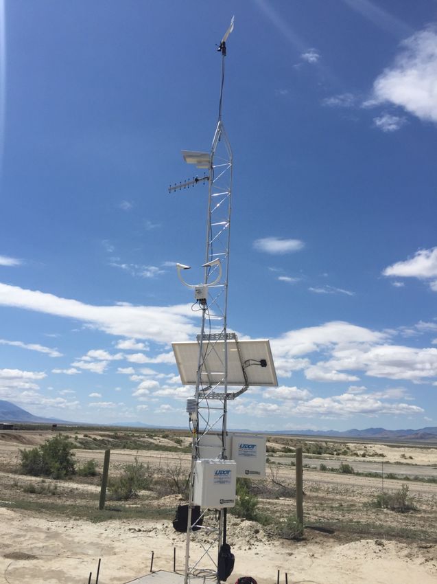
Outline
Overview of Pathfinder
Introduction
Brief History
Field Instrumentation
RWIS Sites
Devices Used
Blowing Dust/High Wind Example
Coordination
Products Issued
Public Messaging and Outreach
Effective Messaging
Unified Message
Pathfinder Collaboration
Federal State Private
Government Government Sector
What Is Pathfinder?
Collaborative effort between NWS, state DOT’s & DOT contractors
Sharing road weather information & forecasts
Creating a unified message to the public regarding transportation
impacts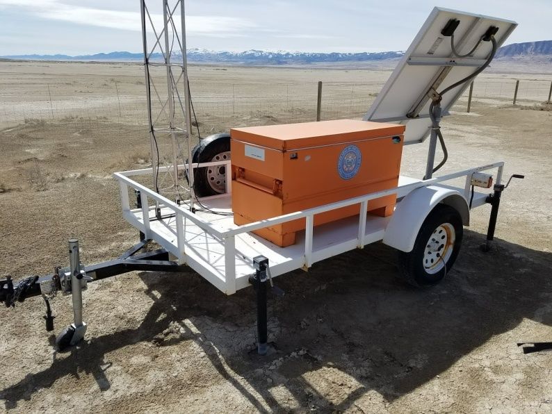
Pathfinder Collaboration

“Not how much snow will fall but how that snow will impact roads”

              What            When              Where
              Type of        When will          Highlight
            storm and        it impact        specific areas
                how          the state          of travel
              intense                           concern
                        Overarching Message
                          Provide tools to
                           influence safe
                         traveling behavior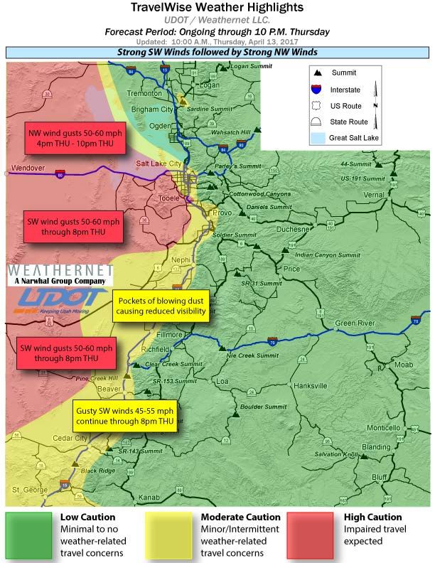
Event Coordination
& Response
Pre-storm briefings 1-3 days prior to event
Based on expected level of impact
Direct communication regarding
impacts with nearby NWS offices
Disseminate internal and public
information ahead of and
throughout winter storms
Benefits wide variety of groups
Impact
17 Jan 2013
What’s the impact?
With a unified message and
trusted channel to disseminate
that information you can alter the
public’s behavior and travel plans
Typical commute peak
10 Jan 2013
Peak commute time shifted two
hours prior to typical
Not just limited to snow events
can be used for variety of
expected weather impacts
Early commute peak
Southbound Northbound
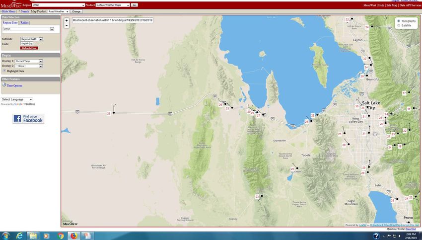
RWIS/Field Instrumentation Largest trouble area is I-80 across Utah’s western desert and Salt Flats Tends to be crosswind 10 permanent RWIS sites on I- 80 between Salt Lake City and Nevada border Localized problem areas due to terrain influence Mesowest

RWIS/Field Instrumentation

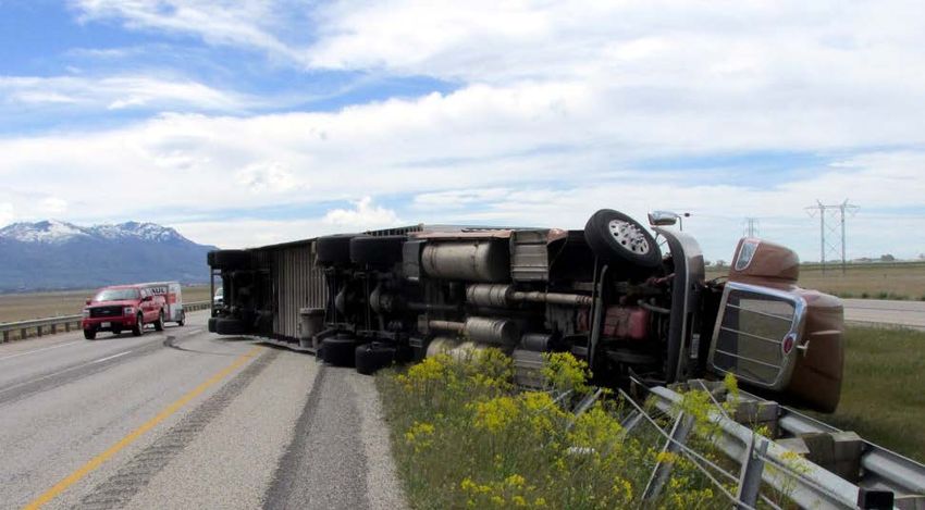
Blowing Dust/High Wind Example Event occurred June 12, 2017 A total of 8 semi-trucks blew over on I-80, interstate was closed temporarily to all traffic A situation not being sampled well by existing sensors Significantly reduced visibility at time of incidents
Blowing Dust/High Wind Example

338 AM MDT Mon Jun 12 2017… WIND
ADVISORY IN EFFECT FROM 9 AM THIS
MORNING TO 10 PM MDT THIS
EVENING... The National Weather Service
in Salt Lake City has issued a Wind
Advisory...which is in effect from 9 AM
this morning to 10 PM MDT this evening.

 * AFFECTED AREA...The west central and
southwest valleys of Utah, the Sanpete
and Sevier valleys, the Great Salt lake
Desert and Mountains, the Salt Lake and
Tooele valleys. and the southern Wasatch
Front.

* WINDS...Southerly winds 20 to 30 mph
with gusts approaching 50 mph.
Blowing Dust/High Wind Example

(10:39 AM) nws-steve.rogowski: Would us issuing a high wind warning help here?
Can include stronger wording in it than a wind advisory. Thanks.
(10:41 AM) dot-scott.jensen: Given the impacts we have seen so far this morning I
certainly don't think it could hurt from our perspective.
(10:42 AM) nws-steve.rogowski: OK, let me know what wording you want in there
and I'll take care of issuing a High Wind Warning for the west desert.
(10:45 AM) dot-scott.jensen: I would just be sure to mention strong cross winds
affecting I-80, especially high profile vehicles of course. Given the placement of the
winds in the west desert there are not a lot of other routes we typically see impacts
on.
(10:46 AM) nws-steve.rogowski: Perfect, thanks. Will be out in 5 minutes. We will
tweet it too.
(10:47 AM) dot-scott.jensen: If it helps with justification for the warning we are now
up to 7 blow-overs.
(10:47 AM) dot-scott.jensen: Appreciate the outreach!
(10:47 AM) nws-steve.rogowski: We appreciate the heads up on the blow overs
Blowing Dust/High Wind Example

1049 AM MDT Mon Jun 12 2017 ...HIGH WIND WARNING IN EFFECT UNTIL 10 PM MDT THIS
EVENING... The National Weather Service in Salt Lake City has issued a High Wind
Warning...which is in effect until 10 PM MDT this evening. The Wind Advisory is no longer in
effect.

•AFFECTED AREA...The West Desert including Interstate 80. * WINDS...Southwest winds 30
to 40 mph with gusts exceeding 60 mph at times.

•* TIMING...Strong southwest winds continuing through the afternoon and gradually
diminishing this evening.

•* IMPACTS...Significant travel impacts are anticipated for high profile vehicles and those
towing trailers, especially where crosswinds are enhanced on east-west routes including
Interstate 80. Blowing dust will also create areas of reduced visibility this afternoon
through early this evening. Wind sensitive operations will be impacted.

•For information on potential travel impacts visit...
http://udottraffic.utah.gov/roadweatherforecast.aspx
Collaboration & Messaging
Focus on the “message”, not the meteorology
“First, it should be understood that forecasts possess no intrinsic value. They
acquire value through their ability to influence the decisions made by users of
the forecasts” – Allan Murphy
Don’t instruct the public, give them tools and options to make
the best decision themselves
Detail road specific impacts
Share plan of actions
UDOT (outreach, products, etc.)
NWS (suite of information services)
Not every situation is the same, messaging can vary based on
area affected, confidence, duration etc.Messaging
Messaging Be as specific as possible regarding impacts Help the public to make the best decision Give observations if possible Update information as it changes
Messaging
Contact Information

Scott Jensen
Salt Lake City, Utah Office
Operations Manager
scottj@nw-weathernet.com
(801) 887-3703
www.narwhalgroup.com
You can also read