Sea-Level Rise: a Slow-Moving Emergency
←
→
Page content transcription
If your browser does not render page correctly, please read the page content below
California State Assembly Select Committee
                        Sea Level Rise and the California Economy

Sea-Level Rise: a Slow-Moving Emergency

                    Select Committee Report of August 2014

                             Richard S. Gordon, Chair

 Katcho Achadjian               Rocky J. Chávez              Al Muratsuchi
  Toni G. Atkins                   Jeff Gorell               Nancy Skinner
 Steven Bradford                Bonnie Lowenthal             Philip Y. Ting

                            Ellen Hou, Committee Staff
Cover photograph was taken by Douglas Moody, Point Blue Conservation
Science, on December 13, 2012 and is courtesy of the California King Tides
Initiative. The photograph shows flooding from king tides at the Highway 101-1
interchange in Mill Valley. Photographs like these of king tides offer a living
record of the changes to our coasts and shorelines and help Californians
visualize how sea-level rise will impact their lives.
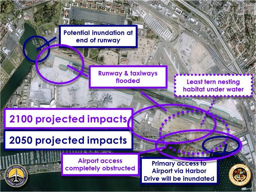
TABLE OF CONTENTS

ACKNOWLEDGEMENTS ........................................................................................................... ii

INTRODUCTION ........................................................................................................................1

KEY FINDINGS ..........................................................................................................................2

POLICY RECOMMENDATIONS ................................................................................................3

SUMMARY OF SELECT COMMITTEE HEARINGS
         Overview and Impact of Sea Level Rise in California ......................................................4
         Impact of Sea Level Rise on California’s Coastal Agriculture, Fishing and Aquaculture
         Industry, and Tourism .................................................................................................... 17
         Impact of Sea Level Rise on California’s Infrastructure ................................................. 31
         How State Agencies are Addressing Sea Level Rise in California ................................ 66

CONCLUSION .......................................................................................................................... 79

ACTIONS TAKEN FROM POLICY RECOMMENDATIONS ..................................................... 80

APPENDIX 1: SELECT COMMITTEE WORKPLAN ................................................................ 81

APPENDIX 2: SELECT COMMITTEE HEARING AGENDAS ................................................. 83

                                                                   i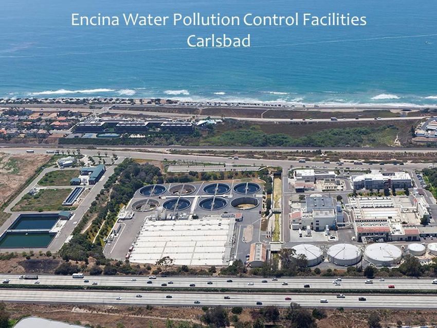
ACKNOWLEDGEMENTS

I want to thank Speaker Emeritus John A. Pérez who authorized the formation of the
Assembly’s Select Committee on Sea Level Rise and the California Economy. His foresight
and leadership has helped to bring attention to a looming crisis in California.

I also want to thank my Assembly colleagues who joined me in a series of Select Committee
hearings. They brought their commitment to protecting and improving California to our
consideration of the issues we discussed.

Thank you’s should also be given to the many experts and professionals who provided
engaging testimony at our hearings.

Finally, I want to offer a special thank you to Ellen Hou. Ms. Hou serves as a Legislative
Assistant in my Capitol Office. She took on the assignment of staffing the Select Committee
and is to be commended for doing an outstanding job. Ms. Hou organized all of our hearings,
managed logistics, and compiled this report. Thank you, Ellen.

Richard S. Gordon
Assemblymember, 24th Assembly District
Chair, Select Committee on Sea Level Rise and the California Economy

August 2014

                                             ii
INTRODUCTION

The sea is rising. The nation’s longest continuously operating gauge of sea level, at Fort Point
in San Francisco Bay, recorded a seven-inch rise in the sea level over the 20th century. As a
result of climate change and global warming, sea-level rise is projected to accelerate during
the next century. Even if greenhouse gas emissions are reduced, residual ocean warming will
cause seas to continue to rise. A 2012 report from the National Research Council found that
the average sea-level rise projections for California are an additional 6 inches by 2030, 12
inches by 2050, and 36 inches (3 feet) by 2100. As a result of these projections, sea-level rise
has been called a slow-moving emergency. The fact is that California is indeed facing an
emergency.

California has 840 miles of coastline ranking third among the 50 states behind Alaska and
Florida for the most miles of coast. San Francisco Bay is highly developed along the shoreline
and faces impacts from sea-level rise. Three quarters of California’s 38 million people live
near the coastline and the San Francisco Bay shoreline.

In addition to homes, existing critical infrastructure – such as roads, hospitals, schools,
emergency facilities, wastewater treatment plants, and power plants – is vulnerable to sea-
level rise. Several California airports are located in coastal zones and rising seas will also
impact goods movement through California’s ports. Sea-level rise also threatens public
access to the coast and its recreational areas. Coastal waters, wetlands, estuaries, riparian
areas, and beaches – which are important environmental and economic resources of California
– are also at risk.

The Assembly Select Committee on Sea Level Rise and the California Economy was
established in 2013 to thoroughly review the challenges ahead in addressing the expected
impacts of sea-level rise on California and its economy. The Select Committee held four
hearings throughout the state to examine sea-level rise’s effect on various sectors and
industries. Topics at the four hearings included projected impacts on: coastal agriculture, the
fishing and aquaculture industry, tourism, ports, roads and bridges, and water and power
infrastructure. The Committee also examined the existing authority granted to state agencies
in regards to preparedness and response to anticipated sea-level rise.

This report summarizes the testimony at the hearings providing highlights as well as insightful
images that put into perspective the risks California faces. The report also includes key
findings and a set of recommendations that was written by committee staff and approved by
the Chair. The findings and recommendations were not voted on by members of the Select
Committee and may not reflect the view of each Select Committee member. This report is
meant to inform and alarm so that California can be proactive in responding to the slow-moving
emergency of sea-level rise.

                                               1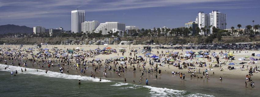
KEY FINDINGS
The following are key findings that highlight the important takeaways from the Select
Committee’s four hearings.
Key segments of California’s economy are at risk. California’s coastal agriculture,
fishing, and tourist industries will be impacted. Airports, ports, and goods movement will be
affected.
Infrastructure is at risk. Critical infrastructure including 3,500 miles of roadways; about
280 miles of railroads; numerous schools, police and fire stations; and hospitals are located
in the coastal zone. Key elements of California’s wastewater treatment capacity and power
generating capacity are located at current sea level.
True vulnerability is sea-level rise plus extreme storms and king tides. King tides are
especially high tides that occur several times each year. The combined effects of current
sea-level rise combined with extreme storm events and king tides are already providing us
with a preview of the new normal that can be expected as the seas continue to rise.
Sea-level rise will exacerbate the problem of saltwater intrusion. Saltwater intrusion
into coastal aquifers poses a high level of risk to agricultural communities along the
California coast. Sea-level rise threatens water supply and water quality by aggravating
saltwater intrusion in our freshwater sources like coastal aquifers, estuaries, and even the
Delta.
Sea-level rise will accelerate coastal and beach erosion. Erosion breaks down natural
barriers such as cliffs, beaches, wetlands, and dunes – all of which act as buffers and
protection for our coastal communities. Beach erosion in particular will negatively impact
California’s tourism industry. Erosion will also have significant impact on private property
including homes and businesses.
Coordinated planning is required in order to adequately prepare. Sea-level rise is an
issue that crosses many sectors and jurisdictions; therefore, collaboration and coordination
are needed to ensure effective planning. Key decisions will need to be reached relative to:
where it would be appropriate to armor the coast, where adaptation is needed, and where
retreat from the coastal zone should be encouraged.
Lack of funding is a barrier for taking action on sea-level rise. Responding to sea-
level rise will be costly. Currently, there is even insufficient funding to support local
governments and others in assessing vulnerabilities, planning, and reducing risk. In fact,
applicants to the Coastal Commission’s Local Coastal Program Assistance Grant Program
requested over five times the amount of available funding.
2
POLICY RECOMMENDATIONS

Educate the public about sea-level rise and its impacts. Education and raising awareness
are key in order to have buy-in from communities to prioritize the issue now. Unfortunately,
sea-level rise is often seen as a future problem; however, we need to reframe the discussion
and inform the public that we are in the middle of an emergency – not at the beginning. The
crisis is already here and action needs to be taken now.

Ensure there is a continued repository for science in the state in order to make
educated policy decisions. Science plays a vital role in informing us about future conditions
and helps frame decision-making and policy responses. The California Ocean Protection
Council should be encouraged and incentivized to bring the best and most current science to
the state.

Establish policy, guidelines, and guidance at the state level to inform planning
decisions. The state should collaborate with local and regional government agencies to
provide clear, consistent, and transparent standards and guidance, including uniform data that
informs and supports local decision making processes. Current projections suggest that the
planning horizon anticipate three feet of sea-level rise by 2100.

Be proactive in planning for sea-level rise. The severity of the impacts of sea-level rise will
be linked to how quickly we take action. Preparing for sea-level rise will be expensive, but the
price will be far lower than the alternative of waiting and reacting to these impacts as they
occur. Planning should include consideration of both sea-level rise and extreme events.

Incentivize sea-level rise planning and adaptation through additional funding. Lack of
funding is a barrier to taking action on sea-level rise. Therefore, additional funding to support
current grant programs as well as the creation of new sources of funding will lead to increased
actions to address the need. It is encouraging that the 2014-15 adopted budget includes
funding for planning in the new California Climate Resilience Account. Future consideration
should be given to a state revolving loan fund to assist communities with adaptation.

Encourage collaborative planning efforts. Coordination and collaboration especially
regional planning is essential, as sea-level rise does not stay within jurisdictional boundaries.
In fact, sea-level rise affects many sectors and agencies, which are often intertwined and
dependent on each other.

Take action now to address sea-level rise, it is not too late. Sea-level rise has been called
a slow-moving emergency. As a result, the future is not all doom and gloom since we have
time on our side to prepare and plan for sea-level rise. Sea-level rise is not a surprise. We
know it is happening and will only worsen. We must take advantage of the time we have to
address this impending emergency now.
                                               3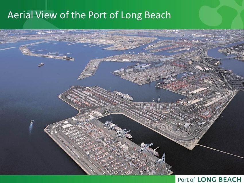
SUMMARY OF SELECT COMMITTEE HEARINGS

                    Overview and Impact of Sea Level Rise in California
                                Wednesday, May 15, 2013
                           9:30 a.m. – 12:30 p.m., Sacramento

The first Select Committee hearing brought in the Natural Resources Agency Secretary as well
as scientists and academics who described the science behind why are seas rising and
provided a broad overview of the threats and challenges facing California, setting the stage for
the remaining hearings and discussion.

Overview of Sea Level Rise in California

John Laird, Secretary, Natural Resources Agency

Secretary Laird began by revealing that the public is aware of greenhouse gas (GHG)
emissions and things that are related to it, but they have yet to develop a real comfort level
with how the state is going to have to adapt to changes in the climate. Broad based education
for the public is lacking.

The Natural Resources Agency is the state’s lead on adaptation and is in the process of
updating California’s 2009 adaptation strategy, which includes oceans and coastal resources.
It is clear that climate adaptation activities to date have been conducted without sufficient
funding, mandate, staffing, or implementing authorities. Secretary Laird stated that the
backdrop for today is that the state has much more science than in 2009 and science in many
ways has started to settle the question of what might be used as a baseline for future sea-level
rise. In fact, the National Research Council has projected sea level to rise in the range of 5 to
24 inches by 2050 and 17 to 66 inches by 2100. The median is somewhere around 14 inches
by 2050 and somewhere around 41 or 42 inches by 2100. Secretary Laird pointed out that it is
very important to look at the median because depending on the success of reducing GHG
emissions, actual sea-level rise could be at the low end or high end of these projections.

Secretary Laird also pointed out that the impacts California faces are not sea-level rise alone,
but extreme storms as well. He provided the metaphor that the situation is not a bathtub
where there is only gradual rise. Instead he asserted that it is the 2-year old child jumping into
the bathtub, which is the extreme event. And it is the extreme event that will especially drive
home what the sea-level rise is and what its effects are on the coast.

The severity of impacts will be linked to how quickly action is taken. Secretary Laird shared
that this is an important point to dwell on because as with Hurricane Sandy, if $15 billion of
infrastructure improvements had been done prior to the storm, it would have mitigated most of
the $60 billion costs that accrued to taxpayers after the storm. He asserted that preparing for
sea-level rise will be expensive, but the price will be far lower than the alternative of waiting
and reacting to these impacts as they occur. These are major issues that have to be dealt with
                                                4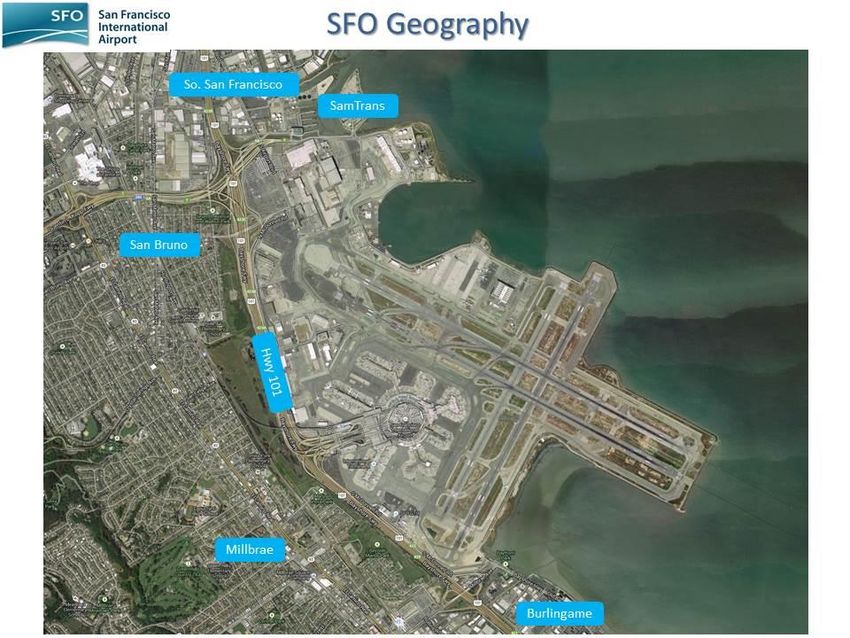
and part of the work is educating the public. Secretary Laird concluded by stating that he looks
forward to partnering with the Legislature in these efforts.

Cat Kuhlman, Executive Director, Ocean Protection Council

Ms. Kuhlman asserted that the sea is rising and is already causing impacts to the California
coast and San Francisco Bay. As a result, sea-level rise poses a severe threat for the future.
She shared that recently volunteers have been taking photographs (below are two examples)
during king tides, which are extreme high tides that occur at predictable intervals during the
year. These king tides document how California’s significant coastal resources are currently
endangered and give an incredible preview of what will happen to communities as the sea
rises. She stated that these images paint a visual picture of something that is otherwise hard
to imagine about how California is going to be changing.

    Photo: Jon Sullivan for the San Diego King Tide Initiative

Ms. Kuhlman pointed out that climate change and sea-level rise have been strategic priorities
for the Ocean Protection Council which was created by the Legislature to bring together the
best science and policy for California’s decision makers both at the state and local level to
protect coast and ocean resources. She asserted that science plays a vital role in informing
the public about future conditions and helps to frame policy responses.

Ms. Kuhlman also shared that California is a leader in taking action to address sea-level rise.
In fact, the Coastal and Ocean Working Group of the California Climate Action Team (CO-
CAT) developed the State of California Sea-Level Rise Guidance Document which is intended
to help state agencies incorporate future sea-level rise impacts into planning decisions. She
stated that the policy recommendations laid out in this document were drafted by consensus
with 16 state agencies1 that have jurisdiction over coastal and ocean matters for California in

1
 The 16 state agencies included the Business, Transportation and Housing Agency, Coastal Commission,
Department of Fish and Game, Department of Parks and Recreation, Department of Public Health, Department of
Toxic Substances Control, Department of Transportation, Department of Water Resources, Environmental
                                                                 5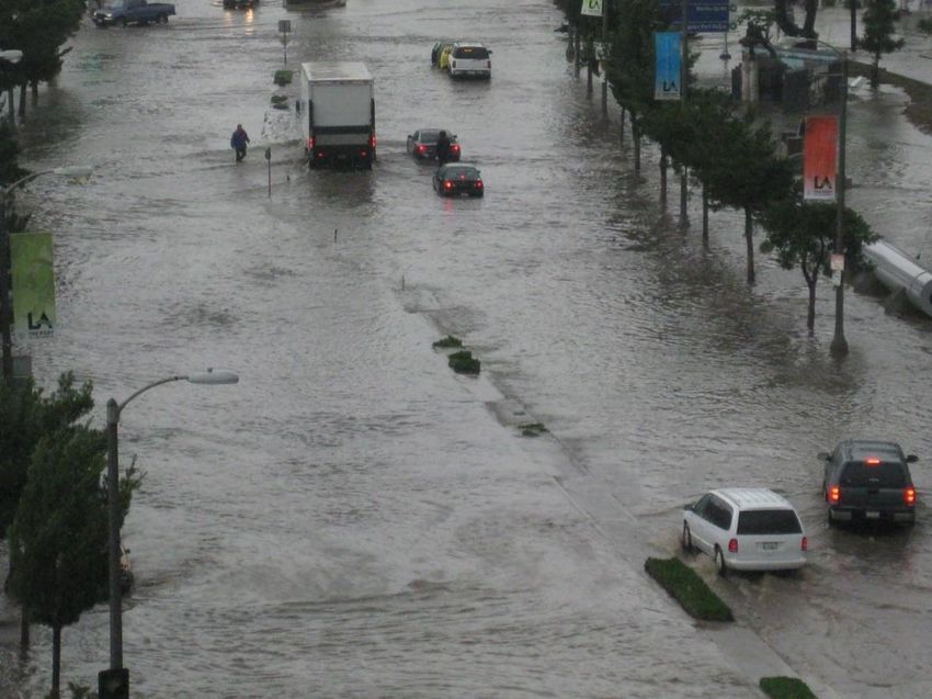
addition to the Ocean Protection Council. She expressed that having guidance on the best
available projections helps prevent confusion about which projections to use for decision-
making.
Ms. Kuhlman advised that it is important to have accurate maps in addition to having good
projections. She shared that the Ocean Protection Council’s Coastal Mapping Program has
produced detailed maps that can be used for evaluating future scenarios. In 2011, the Ocean
Protection Council adopted a Sea-Level Rise Resolution stating that all state agencies and
non-state entities implementing projects using state funds or on state lands should incorporate
consideration of the risks posed by sea-level rise into all decisions. In terms of funding, she
stated that the Ocean Protection Council provided $2.5 million to fund projects in partnership
with the Coastal Conservancy and the Coastal Commission. This funding will support sea-
level rise analyses and projects that will result in updated Local Coastal Programs, which are
key planning tools for addressing sea-level rise.
Furthermore, Ms. Kuhlman pointed out that many individual agencies are taking action to
address sea-level rise, with projects such as:
Caltrans – Transportation Hot Spot Map – recently completed;
State Lands Commission – coordinating with leases and grantees about taking action
on sea-level rise;
San Francisco Bay Conservation and Development Commission (BCDC) – working with
other regional governance entities on developing a Regional Adaptation Strategy for the
Bay Area;
Coastal Commission – developing guidance for addressing sea-level rise for permitees;
Department of Public Health – awarded four-year funding to evaluate health impacts
from climate change, including from sea-level rise; and
Coastal Conservancy – developing strategies to address sea-level rise in wetland and
other shoreline habitats in San Francisco Bay.
Ms. Kuhlman emphasized the need to use the state’s coastal natural resources as part of the
equation for solutions. In making these decisions, the importance of the natural world must be
factored in. There is a growing body of research that shows the importance both from a
resource perspective and an economic perspective that protecting and restoring ecosystems is
both effective and cost effective. She asserted that this is another area where additional work
and additional research is going to be pivotal for the state.
Protection Agency, Governor’s Office of Planning and Research, Natural Resources Agency, Ocean Science
Trust, San Francisco Bay Conservation and Development Commission, State Coastal Conservancy, State Lands
Commission, and State Water Resources Control Board.
6While the Ocean Protection Council has made preliminary investments in science, policy, and
tools for decision makers, Ms. Kuhlman conveyed that California has a solid government
infrastructure that has been and can be responsive. She asserted that California is in the lead
compared to other states, but the sea is rising rapidly and there is a need to redouble efforts
with both energy and courage. She also recommended that achieving a resilient coastline will
require partnerships, not only the ones already created, but new and innovative partnerships,
sound science that is responsive to decision makers at all levels of government. Most
importantly, she stated that there is a need for creative incentives and requirements to
evaluate all projects in light of climate change and sea-level rise. Ms. Kuhlman concluded that
the Ocean Protection Council is committed to providing leadership and funding to prepare for
sea-level rise. The Ocean Protection Council’s goal is to work collaboratively with the
Legislature, other state agencies, local agencies and interested partners to develop long range
strategies that promote the resiliency of coastal communities, and restore and protect
California’s natural resources.
The Impact of Sea Level Rise: Threats and Issues Facing California and its Economy
Dr. Gary Griggs, Distinguished Professor of Earth Sciences and Director of the Institute of
Marine Sciences, University of California Santa Cruz
Dr. Griggs observed that climate change and sea-level rise is nothing new, and has been
known about for a long time. He shared that sea-level rise became known mid-way through
the last century, where scientists learned that climate differed across the world, but also that
climate has changed over time. As it gets warmer, ice melts and oceans expand. Scientists
believe that ice melting accounts for about two-thirds of the rise in sea level. In addition, the
density of the water as it gets warmer expands, which also raises sea level. Further, large-
scale tectonics essentially what the land is doing, for example sinking, can also lead to sea-
level rise.
Dr. Griggs stated that in the short-term, tsunamis can raise sea levels fifty feet or more over
minutes in areas affected. Tides which go in and out every day also can change sea level in
the short-term. Storm surges will do this as well and an El Niño can raise sea level for several
months at a time. What the Select Committee is focused on is the long-term sea-level rise
over millimeters per year. He conveyed that this seems minuscule, but the impact is much
greater over the long-term. It is important to note that it is the short-term events which are
going to be more problematic in the near future. As demonstrated by the three images on the
following page, flooding from seawater is already a problem and this is without the expected
projections of additional sea-level rise. Therefore, sea-level rise will only worsen and add to
the problem.
7Courtesy of Dr. Gary Griggs, Presentation to Select Committee
Dr. Griggs asserted that sea-level rise over the last several hundred years prior to about 1850
did not change a whole lot. When scientists started measuring with tide gauges, sea level rose
at a rate of about 1.7 millimeters per year. He stated that in the last twenty or so years,
scientists can now measure sea-level rise through satellites and it appears that the rate has
nearly doubled. Sea-level rise will cause waves and run-up to reach higher elevations and
extend farther inland. Shoreline flooding and coastal erosion will increase in magnitude and
duration over the 21st century, increasing exposure of shoreline development to impacts of
waves and high water. Dr. Griggs recommended looking at recent El Niños to know what to
expect for the immediate future. He also shared sobering real world realities. Oakland
International Airport begins to go underwater with 16 inches of sea-level rise. San Francisco
International Airport begins to go underwater at 16 inches of sea-level rise at high tide. In
closing, Dr. Griggs encouraged the Select Committee and the public to think about
infrastructure of that sort to spur action on the issue as well as not forgetting the short-term
events when looking at the total impact of sea-level rise to communities.
Dr. Patrick Barnard, Coastal Geologist, U.S. Geological Survey Pacific Coastal and Marine
Center, Santa Cruz
Dr. Barnard continued the conversation by also discussing the complexity of the situation for
California’s coast in particular looking at the combined effects of sea-level rise and coastal
storms.
Below are the kinds of effects that can be expected in coastal settings from projected climate
trends such as increased sea-level rise:
Accelerated beach erosion rates;
Greater incidence of cliff failures;
Landward translation of coastal flooding and inundation;
More dangerous navigation conditions, particularly acute for our major harbors and
ports in California;
Beach/shore safety more often compromised; and
Saltwater intrusion into coastal aquifers.
8Below are photos of vulnerable coastal communities that are located right on the beach.
In addition, critical infrastructure along the coast that is “in the line of fire” include power plants
and numerous wastewater treatment plants such as the Hyperion Wastewater Treatment
Plant, Los Angeles’ oldest and largest wastewater treatment facility, shown below.
9Furthermore sediment supply is another issue. Dr. Barnard expressed the importance and
need for sand for beaches, since beaches act as a buffer as they are the first line of protection
for coastal communities.
As mentioned previously, the problem is not just sea-level rise, but the combined effect of sea-
level rise and extreme storm events. So instead of just a three meter bathtub based on sea-
level rise and tide difference, an additional 5 meters or more resulting from an extreme storm
would be added on top of a three meter rise. Dr. Barnard emphasized that this is what
scientists have to model and understand because this will give a true sense of the vulnerability
of the coast. Below are two images of Stinson Beach, one showing what the beach will look
like with sea-level rise only and the other showing the combined effect. When the annual
storm is added to the model, the flooding situation is much more severe and even shuts down
the Highway 1 corridor.
Studies have shown that the frequency and intensity of events have increased off California’s
coast over the last half century or so and that the extreme waves are getting bigger and faster.
Dr. Barnard urged that this is what especially needs to be worried about in terms of coastal
impacts. He stated that today’s 100-year coastal water level event in California is projected to
10occur every one to five years by 2050, much more frequently, and will have the greatest impact
on low-lying coastal areas such as Imperial Beach, Coronado, Mission Beach, Venice, Oxnard,
and San Francisco Bay to name a few. Flooding events that are seen with king tides will also
occur more frequently. Unfortunately, none of these projections incorporate shoreline change.
As sea levels rise they tend to drive beaches further inland, which will increase communities’
exposure.
In concluding, Dr. Barnard stated that sea-level rise compounds the problem. Process-based
models need to take into account all aspects of future coastal water levels, especially due to
extreme storms. He suggested that models should also include regional and local sea-level
rise factors to reflect coastal vulnerability. Therefore, a statewide, systematic approach to
assess the impact of climate change must include sea-level rise and storms.
Becky Smyth, West Coast Director / Regional Division Chief, National Oceanic and
Atmospheric Administration Coastal Services Center
Ms. Smyth’s presentation took the next step and talked about how a decision maker in the
state or local government gets information on sea-level rise in a useable format. She also
spoke to what tools are available, what tools are still needed, and how the National Oceanic
and Atmospheric Administration (NOAA) is starting to move forward on this.
Ms. Smyth stated that there are a lot of tools from the local, state, and national level that take
all this information related to sea-level rise and start putting it into places that can help make
decisions. She pointed out that these tools do not make decisions for policymakers or
planners, instead they provide information in a way that decision makers can start assessing
the tradeoffs and risks. Ms. Smyth explained that the different types of tools vary on what she
called “The Simpsons” scale, from a tool that Homer Simpson would use which would be easy
and simply visualizes the sea-level rise to more complex tools that Lisa Simpson would likely
use.
One tool in Ventura that the Nature Conservancy is utilizing with many local, state, and federal
partners is the Coastal Resilience tool, which looks at how natural systems can be used to
help with adaptation as opposed to only relying on seawalls. Our Coast Our Future is a local
Bay Area tool that is more sophisticated and looks at the full range of impacts and what will
that mean, in line with what Dr. Barnard was suggesting. In addition, the California Energy
Commission funded research that is presented through Cal-Adapt which provides a sea-level
rise threatened areas map in order to view areas along the coast that may be most at risk,
providing a baseline look statewide.
11Ms. Smyth also discussed NOAA’s Sea Level Rise and Coastal Flooding Impacts Viewer
(shown above). This is a screening tool that shows where the vulnerable areas are, with up to
six feet of sea-level rise. Communities can utilize this tool to start looking at planning for three
feet of sea-level rise for example and find out where their vulnerable areas are at this level of
rise and then where more studies are needed. Included in this viewer is a visualization tool
that can show the public how their region will be impacted by a specified amount of sea-level
rise. There is also a social vulnerability screening tool.
She stated that California is fortunate in that people are already using this information to
change the way that they are making decisions. For example, planning and permitting staff at
San Francisco Bay Conservation and Development Commission (BCDC) used the Sea Level
Rise Coastal Flooding Impacts Viewer and associated data for screening proposed projects.
In addition, the Sea Level Rise and Coastal Flooding Impacts Viewer is included in grant
criteria for project applications to the state’s Local Coastal Program Sea-level Rise Grant
Program.
Ms. Smyth concluded that NOAA has worked with an enormous number of state agencies and
that California is a leader on this issue.
12Dr. Peter Gleick, President, Pacific Institute
According to Dr. Gleick, climate change will inevitably change the character of the California
coast at very high economic cost through increased flooding and erosion. As a result, large
populations and infrastructure are at risk simply because of the way the state has developed.
Dr. Gleick shared that the Pacific Institute, with support from the state, completed a detailed
analysis of the current population, infrastructure, and property at risk from projected sea‐level
rise if no actions are taken to protect the coast. The Pacific Institute’s report entitled The
Impacts of Sea-Level Rise on the California Coast uses projections developed by the state
from current best estimates, but does not reflect the worst‐case sea‐level rise that could occur.
The report also evaluates the cost of building structural measures to protect high-valued
locations, but Dr. Gleick pointed out that if development continues in threatened areas, all of
these estimates will rise substantially.
Below are a few of the key findings from the report:
sea level increases will put 480,000 people at risk of a 100‐year flood event, given
today’s population (populations in San Mateo, Alameda, and Orange Counties are
especially vulnerable);
sections of the coast not vulnerable to flooding are often highly susceptible to erosion
and the Pacific Institute estimated that a 1.4 meter sea‐level rise will accelerate erosion,
resulting in a loss of 41 square miles of California’s coast by 2100;
among those affected are large numbers of low‐income people and communities of
color;
a wide range of critical infrastructure, such as roads, hospitals, schools, emergency
facilities, wastewater treatment plants, power plants, and more will also be at increased
risk of inundation in a 100‐year flood event; and
as a partial estimate of what is at risk, the study calculated that nearly $100 billion (in
year 2000 dollars) of property (measured as the current replacement value of buildings
and contents) is at risk in the expanded flood zones as shown by the image on the next
page.
13So, what can be done? Dr. Gleick provided the following recommendation to the Select
Committee. He suggested that the state integrate climate change and sea-level rise into all
coastal design and that new development needs to be limited in high risk areas. In addition,
the remaining wetlands and nearby undeveloped areas need to be protected. Furthermore,
there is a need to measure the social and environmental costs of adaptation strategies
including environmental justice implications of the risks that are faced. Dr. Gleick also
mentioned modernizing flood insurance maps and programs that need to be done at the
federal level and the state level. Disaster planning is also key and has to take into account
those who are the most vulnerable. Communities most vulnerable to harm have to be involved
in decisions about future development such as preparation and adaptation strategies. Finally,
Dr. Gleick asserted that adaptation planning needs to begin now in order to substantially
reduce the risks that California faces. He concluded that if nothing is done, the infrastructure,
buildings, and resources that are going to be at risk are going to have a larger impact and will
be more expensive.
14Preparing for the Effects of Global Warming: The American Public’s Perspective on Sea
Level Rise
Meg Caldwell, Executive Director, Center for Ocean Solutions, Stanford Woods Institute for the
Environment
Climate change is a major priority for the state of California, and preparation for the
unavoidable consequences of climate change is a priority for Governor Brown’s administration.
California state agencies, departments, commissions and councils have conducted numerous
studies on the impacts of climate change and are poised to implement adaptation strategies
and policies. Yet coastal managers throughout the state express concern about political will
and public support for action, and note these to be barriers to successful implementation plans.
However, a recent Stanford University poll suggests that the public strongly supports
adaptation action and that these perceived barriers to progress may reflect a misunderstanding
of the public’s concerns. Ms. Caldwell presented the results of this survey which are the
product of Stanford University’s Center for Ocean Solutions and the Stanford Woods Institute
for the Environment.
The following are the overarching findings of the poll:
The California public believes that global warming will cause sea levels to rise (76%)
and that global warming-induced sea-level rise will be a serious problem for the U.S.
(79%).
The California public overwhelmingly supports preparing now for the impacts of global
warming (85%) rather than waiting (13%).
The California public, more so than the general U.S. public, believes state government
should take significant steps to lessen the consequences (59% of Californians vs. 53%
of the national public) of sea-level rise.
Californians are most supportive of adaptation strategies that include:
o improving building standards for coastal development (62%),
o limiting rebuilding of damaged structures (55%),
o limiting new development in flood and inundation zones (53%), and
o building sand dunes as a means of coastal protection (48%).
The California public, more so than the U.S. public, believes that adaptation action will
have a positive impact on the state’s economy (52% vs. 38% for the U.S.) and jobs
(60% vs. 42% for the U.S.).
Ms. Caldwell concluded that while previous work on climate adaptation has shown that there
are many barriers that coastal practitioners face in successfully adapting to climate change
(including lack of time, lack of capacity and money), one barrier frequently mentioned by
coastal practitioners is lack of political will and public support. However, she pointed out that
these results suggest that the American and Californian public firmly believes that climate
15change is happening and it is causing sea levels to rise and storms to be worse and that these
are bad. She further expressed that the public strongly supports preparing for these changes
before damage is done and Californians believe preparation will help the California economy
and jobs; they also support a leadership role for government in proactively addressing
development in coastal hazard areas.
16Impact of Sea Level Rise on California’s Coastal Agriculture, Fishing and Aquaculture
Industry, and Tourism
Wednesday, July 24, 2013
2:00 p.m. – 5:00 p.m., Half Moon Bay
The second Select Committee hearing looked in-depth at three industries vital to California’s
economy that are affected by sea-level rise: coastal agriculture, fishing and aquaculture
industry, and tourism. Representatives from each of these three industries discussed how
they were being directly impacted.
Impact of Sea Level Rise on Coastal Agriculture
Mary Scruggs, Supervising Engineering Geologist, California Department of Water Resources
Ms. Scruggs provided an overview of groundwater and the issue of saltwater/seawater
intrusion that sea-level rise exacerbates. Groundwater varies throughout the state and is
managed at the local level in California. There are 515 alluvial basins and sub-basins in
California. Groundwater provides 32 to 48 percent of the state’s overall water supply based on
numbers from 2005-2010. This is an enormous amount of the water use in the state.
Ms. Scruggs pointed out that seawater intrusion in California is not a new issue. Back in 1975,
the Department of Water Resources published a bulletin, which identified areas that were
impacted by seawater intrusion. She stated that seawater intrusion is the movement of ocean
water into fresh groundwater, causing contamination of the groundwater by salt. It is a natural
process that can be made worse by human activities and sea-level rise. Virtually all coastal
aquifers around the world experience seawater intrusion to some degree due to the density
differences between saltwater and freshwater. Saltwater is heavier and more dense so it is
going to sink and freshwater is lighter so it is going to float more. The image below is of a
confined aquifer and shows the mixing zone between the freshwater and seawater.
17When a well is added and pumping occurs, seawater is pulled in towards the well. Therefore,
seawater intrusion is induced by groundwater pumping. With sea-level rise in addition, there
will be additional pressure which will exacerbate seawater intrusion due to the differences in
density. Ms. Scruggs emphasized that whether there is groundwater pumping, sea-level rise,
or both, seawater intrusion should be paid attention to because once the groundwater is
contaminated with saltwater the aquifer is often lost. In coastal areas where groundwater is
used for potable or agricultural purposes such as the Central and West Coast Basins in Los
Angeles County, intrusion can be a serious problem resulting in the shutdown of wells or
necessitating expensive desalination treatment.
So, what can be done to prevent saltwater from contaminating groundwater? There are
several potential protective measures. Ms. Scruggs commented that it depends on the type of
basin, the political dynamics of the area, the authority to take action, and the funding available.
One option is reducing groundwater use through conservation and by limiting the groundwater
pumping. Another option is developing new water supplies such as tertiary treated water for
agricultural crops, expanding or rehabilitating of surface water reservoirs, and importing new
surface water supplies. Also, on-site control can be implemented, such as refraining from
pumping the well, moving the well further into the basin, or adding an injection well (shown
below) to inject freshwater back into the ground to act as a barrier and block the intrusion.
18In order to prevent and utilize the protective measures, Ms. Scruggs stated that monitoring is
critical. A program initiated by the Legislature in 2009, is the California Statewide Groundwater
Elevation Monitoring (CASGEM). It is a program that Department of Water Resources is
responsible for and provides groundwater elevations and monitoring throughout the state.
Groundwater has ongoing challenges, especially funding, since programs are often not funded
at the state or local level. Fortunately, CASGEM’s funding was reauthorized in the 2014-2015
budget in order to continue the implementation of the program. This is definitely a start, but
additional funding is still needed. Ms. Scruggs conveyed that authority is also a huge issue.
Who has the authority to do it? There are overlapping jurisdictions. As a result, groundwater
management varies from very well managed to not managed at all. The importance of the
groundwater varies throughout the state too, so this is why lack of publicly available data
continues to be a challenge. Fundamental data is needed such as assessments and
monitoring because by the time a problem occurs such as saltwater having entered the
groundwater, the aquifer is lost and it is too late. Proactive steps need to be taken. In
addition, the increasing demand on groundwater is another challenge. Ms. Scruggs pointed
out that as dry years continue, reliance on groundwater increases. Saltwater intrusion and
how sea-level rise will exacerbate the problem and impact the water quality is a critical issue
that the state is facing. In her closing, Ms. Scruggs emphasized that cooperation and
integration is needed to meet these challenges moving forward.
Norm Groot, Executive Director, Monterey County Farm Bureau
Mr. Groot began his presentation by referencing a 2011 survey that stated that the economic
value of all agricultural production in Monterey County is $8.2 billion. He also shared that the
agricultural industry, which supports one of every three jobs in Monterey County, is over three
times greater than the tourism industry in the County. Over 45,000 people in the county are
employed in direct agricultural production and the agricultural sector in the county is the 4th
largest in state and larger than 20 other states.
Monterey County has an estimated 22,000 acres of irrigated agriculture where much of the
land is at current sea level elevations and are protected by sand dunes. Salt levels are already
building in soils due to ocean proximity. As a result, Mr. Groot asserted that saltwater intrusion
is one of the biggest issues right now. In Monterey County, saltwater intrusion was first
determined in the 1940s due to over pumping of the Salinas River Groundwater Basin.
Because of the intrusion, the grower community built and paid for numerous projects that are
designed to halt and eventually reverse saltwater intrusion. About $330 million was invested to
date in net present value to actively try to solve the issue.
The image on the left side of the next page shows a saltwater intrusion map from a 2011
survey by the Monterey County Water Resource Agency. The image illustrates the extent of
saltwater intrusion at its farthest point, almost 10 miles inland, encroaching on city of Salinas.
19Colors reflect periods of time of saltwater intrusion and in recent years the colors have gotten a
lot smaller. Saltwater intrusion is slowing due to the projects that have been built to stop the
intrusion and the growers hope to continue to see positive results.
Mr. Groot also pointed out that sea-level rise also affects increased losses of tidal marshes
and sloughs. The image above on the right side of the page shows a slough adjacent to
farmland which is vulnerable to flooding as sea levels rise.
Mr. Groot stressed that reductions in viable land within the coastal zone will curtail agricultural
production of products such as artichokes, leafy greens and strawberries in Monterey County.
In addition, the development of the Monterey County wine corridor will be impacted due to
increased salinity in the soils and wells, as the land could become barren. Forced conversion
to other uses will impact coastal zone areas with valuable farmland which will be lost when
sand dune barriers collapse. In addition, costs to protect levees and coastal estuaries may be
more than locals can afford. Further, water quality will change in the Delta region as sea levels
change and fresh water can become more brackish and scarce. Mr. Groot is concerned that
this will affect California’s economy and environment. Locally in Monterey County, municipal
water supplies that depend on local groundwater basins are also starting to see impacts and
will incur additional costs for treating higher salinity levels.
In conclusion, Mr. Groot stated that saltwater intrusion into aquifers is slowing, but the
pressures are going to mount as sea levels rise and lead to more groundwater contamination
and soil salinity. The future of agriculture is at stake and deeply impacted by this issue.
20Dr. Rosemary Knight, Professor of Geophysics, Stanford University
Saltwater intrusion poses a high level of risk to agricultural communities along the California
coast, where there is a dependence on coastal aquifers for irrigation. Saltwater intrusion is
driven by withdrawal of groundwater from aquifers, and by rising sea level. Dr. Knight revealed
that while saltwater intrusion can occur gradually over decades, there is a critical point beyond
which the dramatic change in salinity can be irreversible, resulting in the loss of a supply of
freshwater. Thus, she asserted that there is a compelling need to map and monitor the
freshwater/saltwater interface in coastal areas so that appropriate water management
strategies can be put in place.
This is why the Center for Groundwater Evaluation and Management at Stanford University is
using geophysics to image saltwater intrusion along the California coast. New and emerging
technologies in this instance are being used as tools for groundwater management practices
such as monitoring. The project that Dr. Knight undertook proposed the use of “sentinel
geophysics” as a new approach to mapping and monitoring the freshwater/saltwater interface.
Geophysical methods, which employ sensors on the ground surface (as shown below), can
image the freshwater/saltwater interface hundreds of meters below the ground and so could be
used as a long-term measurement system to understand and monitor saltwater intrusion.
Courtesy of Dr. Rosemary Knight, Presentation to Select Committee
Over the past two years Dr. Knight acquired a high-resolution large-scale geophysical image of
saltwater intrusion along a seven kilometer segment of beach between Seaside, CA and
Marina, CA. The data provided a 2D image (seen on the following page) of the electrical
resistivity to a depth of approximately 150 meters. What is clearly seen in the image are
regions of saltwater (warm colors, reds) and freshwater (cool colors, blue).
21The next steps for Dr. Knight are acquiring data for 40 kilometers along the coast of Monterey
Bay in order to see to a depth of 300 meters. She would like to do similar measurements, but
this time, fly a helicopter along the California coast using airborne electromagnetic survey to
get similar images.
Dr. Knight asserted that the threat of saltwater intrusion requires a proactive, data-driven
approach. At the small scale and large scale, data is needed to provide an improved
understanding of the extent of, and controls on saltwater intrusion. A large-scale, big picture
perspective is critically important as groundwater and seawater do not stop at jurisdictional
boundaries. Long-term monitoring allows for adaptive groundwater management. Dr. Knight
concluded that geophysical methods offer fantastic tools that can provide a cost effective
means of undertaking this form of data-driven, science-based groundwater management.
22Impact of Sea Level Rise on Fishing and Aquaculture Industry and the Effects of Ocean
Acidification
Dr. Gretchen Hofmann, Professor of Marine Biology, University of California Santa Barbara
Dr. Hofmann stated that ocean acidification related to climate change is an economic and
emerging issue for California. Ocean acidification is a carbon dioxide problem. 30 to 50
percent of atmospheric CO2 is absorbed by the world’s oceans. When greenhouse gases
dissolve, it changes the pH of the ocean and makes the ocean more acidic. In fact since pre-
industrial revolution global ocean pH has declined (become more acidic) by 0.1 pH, which can
mean life or death for some of the ocean’s organisms. As Dr. Hofmann reminded, big things
can happen with just a small change in the number. Organisms that make calcium carbonate
hard parts (shells and skeletons) are affected by the change in the ocean’s chemistry, which
decreases carbonate ions which are the building blocks for organisms’ shells. With fewer
building blocks, the harder it is to make a shell. Calcifying organisms such as the ones shown
below are threatened by ocean acidification. Oysters and sea urchins have a large economic
importance. Calcifying algae, an important part of the ecosystem, and coccolithophores, which
make oxygen, are both affected.
Dr. Hofmann asserted that the state stands to lose coastal ecosystems, cultural identity as
Californians, food sources (aquaculture), and recreation in the form of fishing and clamming.
In order to avoid emergency room science and address this issue, decision-making and
science need to be combined. Three strategies that Dr. Hofmann suggested that can be done
now are: (1) learn about the natural variability of pH in important coastal marine ecosystems
through sensors in the water measuring pH along the California coast; (2) assess adaptive
capacity of key organisms such oysters, sea urchin, or rock fish and look for genetic variation
and their physiological resilience and tolerance; and (3) most importantly work collaboratively
as a scientific community to address these challenges.
23Zeke Grader, Executive Director, Pacific Coast Federation of Fishermen’s Associations
The Pacific Coast Federation of Fisherman Association represents commercial fisherman
along the coast, mostly owner operators, family fisherman, and small boat fisherman. Mr.
Grader stated that commercial fishing is expected to be one of the industries to be affected first
by climate change as well as being one of those to suffer the most severe impacts. Those
anticipated impacts include: (1) ocean acidification and its effect on both shellfish and finfish
populations, (2) a rise in sea temperature and changing currents affecting fishing patterns and
fish migration, (3) more severe weather conditions affecting safety and days-at-sea fishing
(expected to reduce annual productivity of fishing men and women), and (4) sea-level rise
affecting the infrastructure that supports the commercial fishing fleet. Mr. Grader conveyed
that fishermen are already witnessing far more extreme weather conditions in the Bering Sea
and ocean acidification threatens the shellfish fishery of the Pacific Northwest.
Sea-level rise is expected to cause many facilities serving commercial fisheries – from ports,
harbors, jetties and breakwaters, marinas, and a panoply of service facilities from fish
processing plants, to boatyards, to ice and fuel docks (as well as the roads and assess ways to
them) to be more vulnerable to wave and surge conditions, if not completely inundated.
Although California has taken some steps to begin to curb carbon emissions aimed at the
causes of climate change, the state still must prepare to adapt for the inevitable change as a
result of past and current carbon emissions into the atmosphere. For commercial fisheries this
means identifying structures and facilities within the coastal zone most at risk from sea-level
rise and begin preparations for their renovation or replacement to meet the anticipated rise in
sea level.
For the physical impacts of sea-level rise, Mr. Grader recommended a three-pronged
approach. First, complete a comprehensive assessment and inventory of current ports and
what is likely going to be changed by sea-level rise projections and whether changes will be
made for 50 years out and 100 years out. The second approach involves requiring planning to
build, rebuild, strengthen, or replace structures and facilities within these ports so that planners
are mindful and must consider what the sea level is going to be in the future in the next 25, 50
or 100 years. Finally, funding becomes a key question. Mr. Grader acknowledged that this is
going to be expensive, so sources of funding will need to be identified to assist local
governments and private businesses to adapt. He asserted that this is where the Legislature
could play a big role. One possibility that Mr. Grader suggested is establishing something
similar to what the Department of Boating and Waterways has which is a low-interest revolving
loan program that could provide the funding that is needed to try and make it less of an
economic hardship for those (local governments and private businesses) that are going to be
affected. In his closing, Mr. Grader articulated that California needs to look at investing in how
we adapt to climate change emphasizing the need for the continuation of scientific research
and the development of technology.
24Greg Dale, Southwest Operations Manager, Coast Seafoods Company
As a shellfish farmer in Humboldt Bay, Mr. Dale has been following sea-level rise and ocean
acidification for some time. He admitted that it is frightening to think about. Mr. Dale sees the
issue of sea-level rise as a planning exercise since sea-level rise is happening and will only
worsen. In Humboldt Bay, Mr. Dale shared that they have 10 inches of geologic activity that
adds to and would exacerbate sea-level rise. In addition, issues like subsidence and storm
events such as king tides need to be considered when thinking about sea-level rise and what
the impacts will be.
Failing infrastructure will also result from sea-level rise. In fact, Mr. Dale pointed to an instance
during king tides where the sewer lines floated. If they are not a high pressure sewer line or
they are not full of water, then they end up floating out of the ground. When this happened,
Humboldt Bay was closed which also closed the area where shellfish are harvested. In
addition, most wastewater treatment plants are at the bottom of the hill and not elevated so
they are going to see these impacts of sea-level rise. Jetties and harbors and other structures
are extremely expensive to engineer and develop. Mr. Dale shared that the jetty in Humboldt
Bay is frequently overtopped by large storms, waves, and king tides. In addition, the local
transportation infrastructure such as road systems and rail is affected by king tides more
frequently as well. Mr. Dale stated that this presents many questions such as: should cities be
protected by levees and pumping; should the area be built up; should infrastructure and cities
be moved; and how much is this going to cost? This is why communities need to plan for
future impacts.
25Mr. Dale conveyed that oyster farmers have similar concerns about water quality,
infrastructure, near shore ecology and see the need for planning ahead. Humboldt County and
the Harbor District are trying to address the levee system around Humboldt Bay. Many private
levees being maintained by private landowners are getting very expensive to maintain. If there
is one person that does not maintain the levee or barrier or protection, then any action taken to
provide protection is a moot point. Another problem is that since the infrastructure is not in
enough disrepair, it is difficult getting funds to fix these problems. The issues that the shellfish
industry faces are not just infrastructure. A lot of their coastal dependent industrial sites have
legacy contaminants on them. Those legacy contaminants today are not necessarily an issue
because many of them have been identified and they are not mobilized or moving. However,
as the water rises, a lot of those legacy contaminants are going to be mobilized and move into
estuaries and near shore environments, which will affect the ecological processes and impact
species living in these environments.
Bruce Steele, Commercial Fisherman
Sea-level rise is tied to ocean heating. Mr. Steele stated that most of sea-level rise so far is
due to the expansion of seawater as it heats up plus some supply from glacier melting.
However Mr. Steele also pointed out that moving into the future, sea-level rise is going to be
dependent on the melting of the ice caps in Antarctica and Greenland.
Mr. Steele revealed that a projection of a five degree increase in average temperature by 2090
would make oceans in southern California similar to Hawaii today, approximately 80 degrees
Fahrenheit. Heat spikes in ocean temperature, like during the 1997-1998 El Niño, would raise
temperatures to greater than 80 degrees which would lead to mortality for some species such
as purple sea urchins, which would greatly impact commercial fisherman.
As has been previously mentioned, it is the confluence of events – major storms, king tides,
and sea-level rise – that will do most damage to California’s coastal harbors and communities
including infrastructure that supports the fishing industry.
So, what can be done? Mr. Steele urged that the state needs to protect our estuary systems
which are essential to fisheries. Bolsa Chica Ecological Reserve is a good example of a
wetland that has been restored. He also recommended that planning for the future needs to
begin now in addition to investing in science. Mr. Steele concluded that collaboration is
essential. In fact, industry is working with scientists. A great example is the oyster industry
working with scientists to deal with the issue of ocean acidification. More of this is needed in
moving forward with issues related to climate change.
26You can also read