Section 4 Cruise ship anchorages - General - Maritime Safety Queensland
←
→
Page content transcription
If your browser does not render page correctly, please read the page content below
Section 4                  Cruise ship anchorages

              General
              In order to meet the growing demand for anchorage sites for visiting cruise vessels eight
              ‘cruise ship anchorages’ have been designated within the ‘Whitsunday Planning Area’
              that are controlled by a joint permitting arrangement involving the Great Barrier Reef
              Marine Park Authority and Queensland Parks and Wildlife Service. Link to Whitsundays
              Cruise ship anchorages.
              Cruise ships are required to carry a licensed pilot in the Whitsunday compulsory pilotage
              area. Anchorages are booked on a ‘first come, first served’ basis.

              Pilotage
              Great Barrier Reef Marine Park regulations introduced in October 2000 require all vessels
              over 70 metres LOA to engage a licensed pilot when transiting the ‘Whitsunday Plan of
              Management’ (WPOM) compulsory pilotage area.
              Furthermore, cruise ships seeking a permit to enter any of the gazetted anchorages and
              conduct tourist activities are obliged under the WPOM to engage a licensed pilot. The
              region is within the jurisdictional limits of Queensland Barrier Reef pilots’ licenses issued
              by the Australian Maritime Safety Authority.
              Pilotage services for cruise ships in the Whitsundays are provided Australian Reef Pilots.
              Preferably four to five days’ notice is required.

              Fitzalan anchorage
              The information on Fitzalan Anchorage is reproduced from a document written by Captain
              J Ellyett — Regional Harbour Master (Mackay) and Captain John Foley (Australian Reef
              Pilots Pty Ltd) in 2009. The material contained in this document contributes to the safe
              and efficient management of shipping within Queensland waters. This does not absolve
              the master of responsibility for all aspects of the safe navigation and operation of the
              ship. This material is current at time of promulgation. Any detail shown in diagrammatic
              form is not to be used for navigational purposes.)
              Fitzalan Anchorage lies close north of Hamilton Island in Queensland’s Whitsunday
              Islands region. It is bounded by Whitsunday Island to the north and east, Hamilton Island
              to the south, and Henning Island to the west. First declared available for cruise ship traffic
              in early 2003, it is one of eight gazetted Whitsunday cruise ship anchorages. In the
              absence of any official name the area is referred to as Fitzalan Anchorage, the name
              Fitzalan taken from a nearby channel between Fitzalan Island and Hamilton Island;
              locally, the region is known as Hamilton Cove. Being almost landlocked, Fitzalan
              Anchorage is in consequence protected from strong winds, ocean seas and swells.
              The recommended anchorage position is approximately 1·8 miles from the landing
              pontoon in Hamilton Island harbour. The harbour contains a marina with 135 berths, plus
              public landing pontoons. Cruise ships anchored in Fitzalan Anchorage are entitled to use
              their tenders to shuttle passengers to Hamilton Harbour.
              Hamilton Island is described as a residential resort, with a range of accommodation
              styles, private residences, specialty shops, restaurants, banks, and a variety of tourist
              attractions on the island itself.

Hard copies of this document are considered uncontrolled. Please refer to the Maritime Safety Queensland website for the
latest version. Port Procedures and Information for Shipping – Whitsundays – May 2018                                    19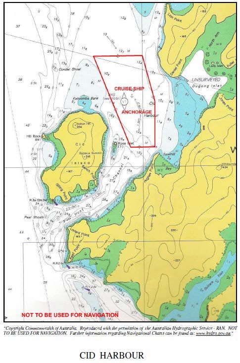
Patronage of Fitzalan Passage by local traffic mostly comprises tourist vessels in transit
              between Hamilton Island and other Whitsunday destinations. Hamilton Harbour is the
              base for many other Whitsunday region tourist attractions. The island has an airport with
              daily direct jet connections to major Australian cities.
              Prior to the opening of Fitzalan Anchorage the most-used cruise ship anchorage in the
              area and traditional focus of Whitsunday cruise ship activities has been Cid Harbour,
              between Cid Island and Whitsunday Island. Cid Harbour is protected from the
              predominant southerly winds and has afforded a safe, calm environment in which to
              transfer passengers into local tourist craft engaged in Whitsunday activities. Northerly
              winds springing up in the late afternoons have, however, sometimes rendered the
              anchorage uncomfortable for passenger transfers and on rare occasions ships have been
              obliged to relocate to Turtle Bay, south of Whitsunday Island.
              In 1998 other cruise ship anchorages — to the west of Hardy Reef (outer Barrier Reef), in
              Funnel Bay (near Airlie Beach), Hayman Island anchorage, Port Molle (west of Long
              Island), and two weather-alternate anchorages south of Whitsunday Island — were
              gazetted under the ‘Whitsunday Plan of Management’ (WPOM).
              Note: It is also, with permission from the Mackay Regional Harbour Master, possible to
              anchor in the main Whitsunday Passage, west of Henning Island, and to run ship’s
              tenders from the anchorage to Hamilton Harbour. The ship must anchor no closer than
              1500m (approximate 0·8 miles) from the nearest island or reef. This anchorage can be a
              useful stop-gap anchorage for ships bound for Hamilton Cove. If the tidal conditions at
              the entrance to Fitzalan Passage are unsuitable at the planned arrival time the ship can
              anchor temporarily off Henning Island and, weather permitting, conduct passenger
              transfer operations to Hamilton Harbour until able to move around into Hamilton Cove.
              Again, in reverse, it can be used if the tidal conditions at the planned departure time are
              unsuitable and the ship has to depart earlier than intended.

4.3.1         Environmental issues:
              Fitzalan Passage anchorage lies within the commonwealth Great Barrier Reef Marine
              Park and the Queensland Townsville/Whitsunday Marine Park; this is a world heritage
              listed area. The anchorage area is zoned ‘Conservation Park Zone’, within which cruise
              ships may neither transit nor anchor without a marine park permit issued jointly by the
              Great Barrier Reef Marine Park Authority and Queensland Parks and Wildlife Service.
              Bookings are made on a first-come-first-served basis and can be made up to three years
              in advance.
              The area that encompasses Fitzalan Anchorage is classified in the ‘Whitsunday Plan of
              Management’ as ‘moderate recreational use’, which is defined as:
              ‘A natural setting that may have moderate levels of visitation, with appropriate moorings,
              and management facilities to manage impacts.’
              The area around the northern tips of Hamilton and Dent Islands is classified ‘developed’,
              which is defined as:
              ‘Immediately adjacent to urban areas and resorts; these areas are the access points to
              the area and a focus for intensive tourism and recreation.’

4.3.2         Application and voyage plan for Fitzalan Anchorage
              ‘Great Barrier Reef Marine Park Authority recommends that a cruise ship operator’s initial
              application for a Great Barrier Reef Marine Park Authority permit and booking for Fitzalan
              Anchorage should include a technical application for assessment and approval by the
              Mackay Regional Harbour Master. Great Barrier Reef Marine Park Authority further
              recommends that a detailed voyage plan, showing the vessel’s entry, anchoring and

Hard copies of this document are considered uncontrolled. Please refer to the Maritime Safety Queensland website for the
latest version. Port Procedures and Information for Shipping – Whitsundays – May 2018                                    20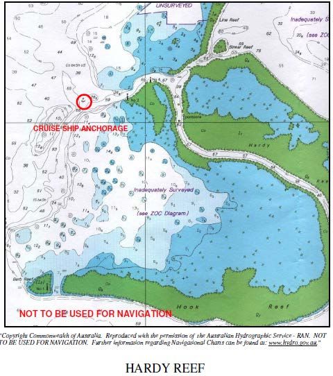
departure intentions, be lodged with the Regional Harbour Master at least three days
              prior to the scheduled arrival, for assessment and approval.’
              Whitsunday Cruise Ship Anchorage Risk Analysis Group discussed the need for the
              Regional Harbour Master to be given advance advice of an applicant cruise ship’s
              relevant technical details, to ensure they meet the specific limitations and requirements.
              This includes the technical details of the vessel, that is LOA, tonnage, draft, manoeuvring
              and navigational equipment, intended date of visit and planned times of arrival and
              departure.
              These documents can be lodged by the ship’s master, owner/operator, or the ship’s
              Australian port agent on their behalf. The details are assessed by the Regional Harbour
              Master, who will then approve or reject, make recommendations, or set conditions for the
              visit. (Form 1 - Fitzalan Anchorage - Application for technical assessment; Form 2 -
              Fitzalan Anchorage - Application to visit, and Form 3 - Fitzalan Anchorage - Voyage plan,
              at the end of this manual).

4.3.3         Maximum length of ship
              ‘Great Barrier Reef Marine Park Authority recommends that the maximum length of ships
              entering Fitzalan Anchorage be provisionally set at around 200 metres WLL.’
              Amendment: On 4 January 2007 the Executive of the Great Barrier Reef Marine Park
              Authority approved the removal of length restrictions at Fitzalan Anchorage. Length
              restrictions henceforth are at the jurisdiction of the Regional Harbour Master Mackay. The
              holders of Great Barrier Reef Marine Park Authority permits which still contain a 200
              metres WLL length restriction can apply to Great Barrier Reef Marine Park Authority to
              have the condition removed.

4.3.4         Minimum manoeuvring equipment
              ‘Great Barrier Reef Marine Park Authority recommends that cruise ships entering Fitzalan
              Anchorage be equipped with at least twin screws and a bow thruster.’
              This was assessed as the minimum manoeuvring kit needed to enable the vessel to turn
              short round, if necessary, on arrival at or departure from the anchorage compound.

4.3.5         Navigation Information for Fitzalan Anchorage
              The current hydrographic chart for the area is metric chart AUS254, ‘Plans in
              Whitsundays’, published by the Australian Hydrographic Service. The relevant plan is
              titled ‘Fitzalan Passage Anchorage’, and has a scale of 1:25,000, with depths shown in
              metres. The area is also shown on chart AUS253, ‘Whitsunday Passage’.
              Parts of the area bounded by Hamilton Island, Henning Island and Whitsunday Island
              (including the northern and southern banks) have been surveyed in detail by Queensland
              Transport’s hydrographic surveys branch. Details can be obtained from the Regional
              Harbour Master.
              The Whitsunday region is now covered by a ‘Differential Global Positioning System’
              (DGPS) network. DGPS offers navigators an accuracy of +/- 10m.
              The Australian Hydrographic Service has established its ‘Electronic Navigation Chart’
              (ENC) vector database along the Queensland coast and including the Whitsunday region.
              This enables the operation of ECDIS (Electronic Chart Display and Information System).

Hard copies of this document are considered uncontrolled. Please refer to the Maritime Safety Queensland website for the
latest version. Port Procedures and Information for Shipping – Whitsundays – May 2018                                    21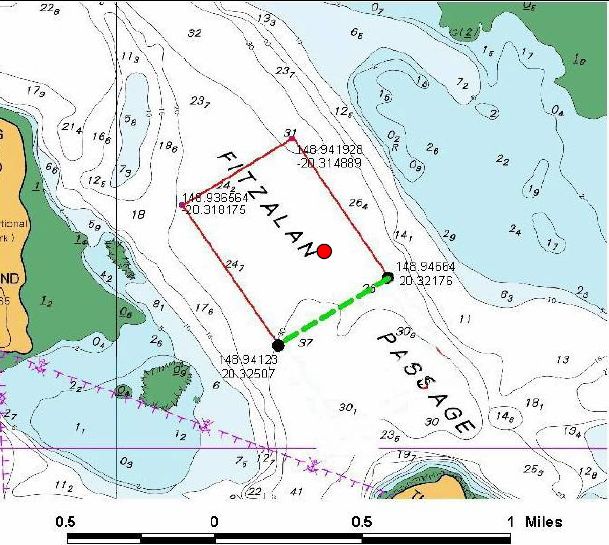
4.3.6         Anchorage details
                                          Not to be used for navigation

             Figure 1 – Anchorage details

4.3.7         Navigation aids
              The navaid network comprises:

                                                                          Charact
    Mark                     Position:           Structure:                            Comments:
                                                                          eristic
                             20o 17·49’S                                  Fl.R.        Provides clearance from
    Reef Point beacon                            Port hand beacon
                             148o 54·76’E                                 2·5sec       the rocks off Reef Point

                             20° 17·815' S                                Fl.Y.        Marks the shallow areas
    Northern Bank buoy                           Special mark buoy
                             148° 54·985' E                               2·5sec       on the Northern Bank.

                             20o 18·792’S                                 Fl.Y.        Marks the shoal area east
    Henning Bank buoy                            Special mark buoy
                             148o 56·057’E                                2·5sec       of Henning Island.

    Henning Entrance         20o 18·422’S                                              Marks the southern limit of
                                                 Special mark buoy        Q.Y
    buoy                     148o 55·380’E                                             Entrance Bank

              Table 3 – Navigation aids

Hard copies of this document are considered uncontrolled. Please refer to the Maritime Safety Queensland website for the
latest version. Port Procedures and Information for Shipping – Whitsundays – May 2018                                    22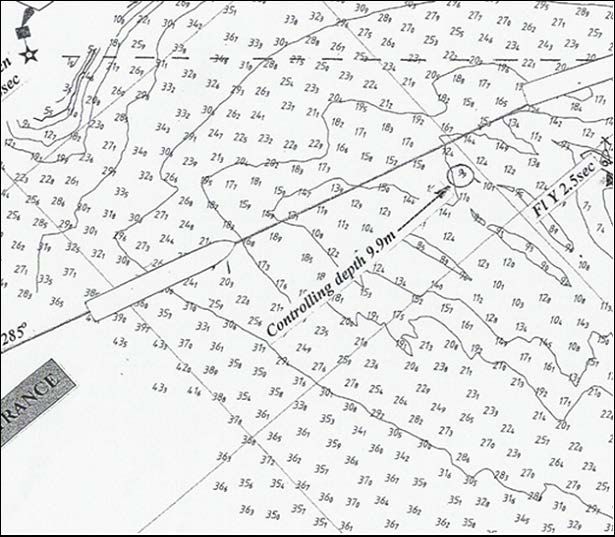
4.3.8         Geographic location
              The anchorage compound (shown above) is bounded by the following coordinates:
              •    latitude 20° 18·893’S, longitude 148° 56·516’E
              •    latitude 20° 19·091’S, longitude 148° 56·194’E
              •    latitude 20° 19·504’S, longitude 148° 56·474’E
              •    latitude 20° 19·306’S, longitude 148° 56·798’E.
              The geographical centre of the compound is latitude 20°19’·2’S, longitude 148°56’·5’E.
              (See recommended anchorage position, 4.3.10)
              In the anchorage compound the depth varies from 21 to 37 metres. The depth in the
              nominal anchorage position is 27 metres. The seabed at the nominal anchor position
              comprises coral, coarse sand, broken shell, and rock.

4.3.9         Anchoring practices
              Cruise ships may drop anchor anywhere within the confines of the compound provided
              the ship remains within these limits at all times. The compound is 0·5 miles across the
              NW/SE axis, and 0·36 miles across the NE/SW axis.
              In calm conditions, cruise ships are tide-rode rather than wind-rode for most of the time.
              They settle heading roughly NNW on the flood tide and SSE on the ebb; the peak of the
              ebb tide is almost twice the strength of the peak of the flood. During the flood tide in
              prevailing E to SE winds the ship usually cants to the east. The tide rarely predominates;
              instead the ship lies on headings between about ENE and SE. This effect gives the ship a
              ‘natural port side lee’, which assists the safe transfer of passengers to tourist craft.

4.3.10        Recommended anchorage position
              In practice, especially during SE winds, an anchorage position slightly SE of the centre of
              the anchorage compound is recommended. This recommended position is 20° 19·26’S,
              148° 56·66’E (indicated by the red dot on the map above).
              Although close to the eastern and southern edges of the anchoring compound,
              experience shows that the ship is extremely unlikely to swing more than one cable in
              those directions. During NW winds, which are rare, it might be more prudent to anchor in
              the geographical centre of the anchorage compound.

4.3.11        Swinging room
              From the central anchorage position to the nearest peripheral danger the ship has a safe
              swinging radius of 667 metres (0·35’). This provides for a minimum clearance of 360
              metres for a ship of 200 metres waterline length anchored to a minimum four shackles of
              cable as recommended by Maritime Safety Queensland and the Australian Maritime
              Safety Authority for the known depth at the anchorage.
              During spring tides, especially during fresh winds, a minimum of six shackles of cable in
              the water is recommended. (‘The World’, on her inaugural visit anchored to five shackles
              in ESE winds of 15-20 knots and began to drag when the ebb tide stream peaked, about
              two hours after HW on a 3·5m tide. Paying out extra cable was sufficient to grip and the
              ship held firmly from then on.)
              During very strong winds, prudence will suggest increasing the scope even more. In all
              cases, the peak of the ebb tide (about two hours after HW) should be monitored for signs
              of anchor drag.

Hard copies of this document are considered uncontrolled. Please refer to the Maritime Safety Queensland website for the
latest version. Port Procedures and Information for Shipping – Whitsundays – May 2018                                    23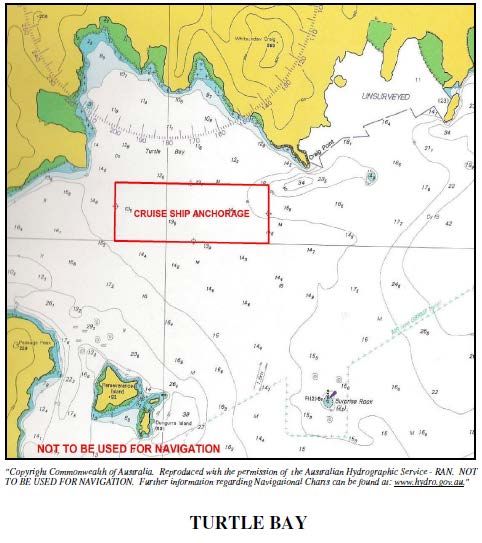
The following table shows the safety margin for ships of various lengths, based on the
              ship anchoring to six shackles in the geographical centre of the anchorage compound.
              Comparison of clear swinging circles — Fitzalan Anchorage — anchoring to 6
              shackles:

               Ship’s WLL (in metres)                     100          150           200          250              300

               LW depth at anchorage                      27           27            27           27               27

               Scope of cable (6 shackles)                164          164           164          164              164

               Max radius of swing*                       262          312           362          412              462

               Safety clearance                           667          667           667          667              667

               Margin                                     405          355           305          255              205

              * Basis: Radius of swing = square root of (length of chain squared - depth of water squared) + WLL

              Table 4 – Fitzalan Anchorage swinging circles

              Note 1:      Waterline length (WLL) is a more appropriate measure for this purpose than
                           length overall (LOA). However, for assessment purposes, LOA is the accepted
                           ship-length method.
              Note 2:      During ‘The World’ visit in March 2003, an analysis of the geographical
                           movement of the ship’s GPS antenna (approx. 10 metres abaft the anchor
                           hawse pipe) showed an overall variation of not more than 0.1 mile.
              Note 3:      Passenger transfers: The decision to conduct passenger transfers is always
                           the captain’s, having regard for company safety procedures and policies,
                           contemporary and expected weather conditions, and technical factors
                           (tenders, platforms, and so on). To improve the lee for passenger transfer
                           operations during slack water in strong winds, when the vessel is classically
                           ‘wind rode’, it may be necessary to skew the ship off the wind with the engines
                           (preferably the stern thruster).

4.3.12        Swinging limits
              ‘Great Barrier Reef Marine Park Authority recommends that anchored cruise ships be
              required to remain within the geographical limits of the anchorage compound at all times,
              even during swinging to the change of tide.” Any extension of that limit is to be
              determined by the Mackay Regional Harbour Master in the light of experience over a
              period of time, also taking into consideration the particular manoeuvring characteristics of
              the applicant vessel and the anticipated conditions during the planned visit.’
              It was recognised that the master and pilot of the vessel should have the professional
              discretion to select an appropriate anchorage position within the compound, depending
              on the weather and tidal conditions at the time.
              Given the environmental sensitivity of the region and the tidal regime, it was agreed to
              impose over-restrictive limits at least provisionally, until — or indeed if — statistical
              evidence in the light of experience suggests some relaxation. Any changes to the criteria
              would be at the discretion of the Regional Harbour Master.

4.3.13        Marshalling craft
              A marshalling craft is required when using Henning Entrance, both for marshalling nearby
              traffic but also to alert people recreating on either Pelican Island or the northern beach of

Hard copies of this document are considered uncontrolled. Please refer to the Maritime Safety Queensland website for the
latest version. Port Procedures and Information for Shipping – Whitsundays – May 2018                                    24
Henning Island that a cruise ship will be passing and may cause a wash up onto the
              beach. Experience indicates that for vessels entering Fitzalan via Reef Point Entrance the
              assistance of marshalling craft is unnecessary. If either the master or pilot considers a
              marshalling craft is necessary, one can be obtained by contacting Hamilton Island
              Marina. (9.5 Hamilton Island request form).

4.3.14        Tidal information and controlling depth
              Tidal heights: There are no published daily tidal predictions for Hamilton Harbour or the
              Fitzalan Anchorage area as such; the ‘standard port’ in the area for calculating
              semidiurnal tidal planes is Shute Harbour. Hamilton Island has a listed ratio of 1·13 on
              Shute Harbour tides. The highest annual forecasted tide at Shute is 4·1 metres, giving a
              prediction of 4·6 metres at Hamilton.
              Controlling depth: The least depth near the track for entering Fitzalan Passage is
              9·9 metres, SE of Reef Point. It is not shown on the hydrographic chart, but can be seen
              on the field plan. Yellow buoys mark the northern and southern extremities of Northern
              Bank, which has shallower depths.
              In practice, the entrance between Reef Point and the Northern Bank buoy is sufficiently
              broad to allow an entrance/exit without having to cross the 9·9 metre patch. The
              controlling depth provision merely adds an extra element of safety, should the ship drift
              over this patch.
              Tidal streams: In early 2000 two tidal stream current meters were laid by the Australian
              Hydrographic Service in the area for a three-month analysis period. A summary of the
              findings show:
              •    direction of stream:      flood — 145° to 165°; ebb — 300° to 340°
              •    strength of stream:       flood — maximum 1·2 knots; ebb — maximum 2·46 knots
              •    time of max rate:         flood — average 1hr 50m after LW (see note 1)
              •    ebb —                     average 1hr-55m after HW
              Note 1: While the time of the maximum rate of the ebb stream after HW varies little, the
              morning flood tide streams peak at about 2 hours 5 minutes after LW and the evening
              flood tide streams peak at about 1 hour 30 minutes after LW.
              Note 2: Data supplied by the Australian Hydrographic Service indicates that the ebb
              stream begins about 30 minutes before the time of HW and runs for 20 minutes after the
              time of LW.

Hard copies of this document are considered uncontrolled. Please refer to the Maritime Safety Queensland website for the
latest version. Port Procedures and Information for Shipping – Whitsundays – May 2018                                    25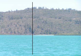
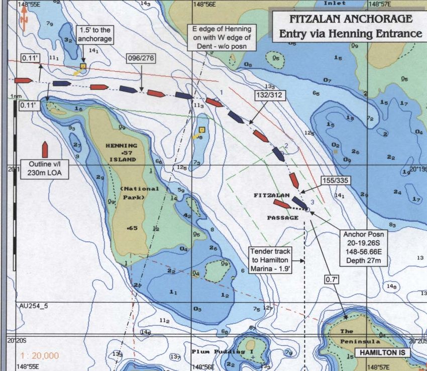
4.3.15        Entry and departure track information

                                       Figure 2 – Entry/departure track into Fitzalan
                                       Anchorage

              There are two entry/departure tracks into Fitzalan Anchorage: Reef Point Entrance and
              Henning Entrance.
              Reef Point Entrance: Directions from sea to the recommended anchorage position (see
              4.3.10).
              From an entry point (20° 17·522’S, 148° 54·032’E) west of Reef Point, set course 105°(T)
              with Whitsunday Island right ahead; a prominent headland will be seen fine on each bow.
              This course just clips the edge of the 10 metre contour on Northern Bank. The least depth
              in the vicinity is the 9·9 metre patch just inside this contour. A special marker buoy (20°
              17·815'S 148° 54·985'E Datum WGS 84) marks the shallower patches.
              The next waypoint is 20°-17·799’S, 148° 55·159’E and next course 132°(T) with the west
              edge of Fitzalan Island right ahead and Reef Point beacon right astern. Pass the
              headland on Whitsunday Island at 0·2 miles.
              The next alter course waypoint is 20° 18·933’S, 148° 56·512’E, and next course 155° (T);
              the radio tower on Hamilton Island is right ahead. Continue on to the anchorage position
              at 20° 19·26’S, 148° 56·66’E, with the northern tip of Hamilton Island distant 0·7 miles.
              Both entry and departure tracks have several very clear visible marks (peaks and islands
              in transit) to guide a vessel safely along the indicated courses. The outward tracks follow
              the reciprocal courses to the inward tracks.
              The depth of water in the entrance channel from Reef Point to the anchorage area varies
              from a minimum 9·9 metres near the approach track SE of Reef Point, to a maximum 27
              metres. Ships of extremely light draft can run directly across the northern bank, if tidal
              height allows.
              The most difficult phase of the operation is likely to be on departure, if the ship is lying
              SSE to the ebb tide; the ship has to turn ‘short round’ before proceeding outwards. It may
              be necessary to close up towards Hamilton Island before turning, to make most use of
              the one-mile-long NNW/SSE clearance between Hamilton Island and Henning Bank.

Hard copies of this document are considered uncontrolled. Please refer to the Maritime Safety Queensland website for the
latest version. Port Procedures and Information for Shipping – Whitsundays – May 2018                                    26
Note: ‘Closing up’ towards Hamilton Island to improve the swing area for departure is not
a breach of the Marine Park regulations.
Henning Entrance: Henning Entrance passes between the northern coast of Henning
Island and the southern extremity of Entrance Bank. It offers a straight track, at least 20
metres deep and 400 metres wide at its narrowest point.
Not to be used for navigation
Figure 3 – Fitzalan Anchorage – Henning Entrance
Hard copies of this document are considered uncontrolled. Please refer to the Maritime Safety Queensland website for the
latest version. Port Procedures and Information for Shipping – Whitsundays – May 2018 27Figure 4 – Henning Entrance
Directions from sea to the recommended anchorage: From an entry point northwest
of Henning Island (20°18·40’S, 148°54·011’E), set course 096°(T) with the 211 metre
peak on Whitsunday Island right ahead. Beneath this peak is a sandy beach, the northern
extremity of which, in line with a gap in the trees on the 211 metre peak, offers a natural
set of leads.
Figure 5 – Henning Entrance – Head mark
The next waypoint is 20°18·624’S, 148°56·143’E and course 132o (T) with the west edge
of Fitzalan Island right ahead and Reef Point beacon right astern.
The next alter course waypoint is 20°18·915’S, 148°56·494’E, and course 155° (T); the
radio tower on Hamilton Island is right ahead. Continue on to the anchorage position at
20°19·26’S, 148°56·66’E, with the northern tip of Hamilton Island distant 0·7 miles.
Note 1: In practice, once through the gap the ship can begin a slow, one-mile radius turn
around the Henning Bank buoy and into the anchorage. A good mark to begin this turn is
when the southern end of Henning Island comes on with the northern end of Dent Island,
both in line with a prominent peak in the distance.
Note 2: Local Queensland Parks and Wildlife officers advise there are no Queensland
Parks and Wildlife Service issues other than the need to pass the island at a moderate
speed.
Hard copies of this document are considered uncontrolled. Please refer to the Maritime Safety Queensland website for the
latest version. Port Procedures and Information for Shipping – Whitsundays – May 2018 28Note 3: While there has been no official study of the tidal influences in Henning Entrance,
local operators anecdotally confirm they are more benign than around Reef Point and this
has been corroborated by experience to date.
Note 4: A small beach on the northern end of Henning is occasionally used for private
recreational purposes. To alert private users of that beach that a cruise ship is passing
and may cause a surge on the beach, Hamilton Island Marina personnel will provide a
marshalling craft for this purpose when ships arrive and depart. This craft operates under
the direction of the cruise ship’s master/pilot (9.5 Hamilton Island request form).
4.3.16 Standby requirements
‘Great Barrier Reef Marine Park Authority recommends that while a cruise ship is
anchored in Fitzalan Anchorage: an active bridge watch with a qualified deck officer be
maintained throughout; the main engines and bow thruster remain on standby; a senior
deck officer, that is, either captain or staff-captain/chief officer, is in attendance on the
bridge at the turn of the tide to monitor the swing of the vessel and ensure it remains
within the confines of the anchorage area at all times.’
Whitsunday Cruise Ship Anchorage Risk Analysis Group considered that the position of
the vessel should be continually monitored from the bridge while it is anchored in Fitzalan
Anchorage. This is to ensure that it remains always within the confines of the marked
anchorage area and to be alert to possible anchor drag.
During most stages of the tide, cruise ships will lay in line with the direction of tide, —
either NNW or SSE. In this position they have the maximum clear room should they drag
their anchors. The closest dangers are to the northeast and southwest of the anchorage
position, and a cruise ship affected by wind can, at slack water, swing its stern in those
directions. If the wind is strong enough it is potentially feasible that a cruise ship could
drag towards those dangers; it is to eliminate all possibility of that happening that
continuous position monitoring be in place on the bridge.
It was likewise considered prudent that a ship should have access to its engines and bow
thruster at reasonably short notice, should the need arise. Even though standard cruise
ship practice is to have the bridge constantly manned by a qualified ship’s officer while at
anchor, Whitsunday Cruise Ship Anchorage Risk Analysis Group considered that at slack
water, when the ship turns to the changing tidal stream, the presence on the bridge of a
senior officer — either captain or staff— captain/chief officer — is warranted.
Note: As an added measure of safety, from experience gained during ‘The World’ visit, it
is recommended that the period of peak ebb tide (approximately two hours after HW) be
also monitored by a senior officer, with an engineer standing by in the engine room ready
for immediate action if necessary.
4.3.17 Chart and position-fixing requirements
‘Great Barrier Reef Marine Park Authority recommends that cruise ships entering Fitzalan
anchorage be equipped with Differential Global Position equipment and also an approved
electronic chart system (preferably Electronic Chart Display and Information System —
ECDIS).”
The Whitsunday region is now covered by a ‘Differential Global Positioning System’
(DGPS) network. DGPS offers an accuracy of +/- 10 metres.
The Australian Hydrographic Service (AHS) has extended its ‘Electronic Navigation
Chart’ (ENC) vector database along the Queensland coast, including the Whitsunday
region. In consequence the local DGPS network and ENC database enables the
operation of ECDIS.
Hard copies of this document are considered uncontrolled. Please refer to the Maritime Safety Queensland website for the
latest version. Port Procedures and Information for Shipping – Whitsundays – May 2018 29Whitsunday Cruise Ship Anchorage Risk Analysis Group considered it wise to take
maximum advantage of the available technology to assist cruise ships entering and
departing from Fitzalan Anchorage and while anchoring.
4.3.18 Limited period access
‘Great Barrier Reef Marine Park Authority recommends that visits to Fitzalan Anchorage
be provisionally restricted to daylight hours, including entry and departure procedures; the
actual entry and departure time limits to be at the discretion of the Regional Harbour
Master Mackay.’
Note: Experience has shown that the available navigation aid network is adequate to
support night-time operations, at the discretion of the Regional Harbour Master.
‘Great Barrier Reef Marine Park Authority further recommends that, provisionally, cruise
ships should enter and exit Fitzalan Anchorage only at slack water or when ‘stemming the
tide’, the actual entry and departure tidal limits to be at the discretion of the Regional
Harbour Master Mackay.
Experience in the first two seasons of cruise ship operations in Fitzalan indicates that in
certain circumstances — at the discretion of the Regional Harbour Master — it is safe for
ships to enter or depart at tidal stages other than at slack water or when stemming the
tide.
Hardy Reef anchorage
Reference Information Remarks
The point within the Great Barrier Reef Marine
Park at or about 19° 44.45´ S, 149° 08.40´ E,
Anchorage
being approximately 1·10 nautical miles due See chartlet below
position
west of the beacon depicted as No. 2 on
hydrographic chart AUS254
Approach From NW staying outside the 30 metre contour
Bottom broken coral, shells
Depth 30-50 metres
and sand
Strong eddies can be
Maximum rise and fall about 4·2 metres. Tidal
Tides experienced in the
streams ebb north and flood south
anchorage area.
Fantasea moored pontoons Explorer 1 and
Facilities
Adventure 1
Protection Exposure for larger vessels from all directions
Vessels to advise Hay Point VTS on VHF
Communications channel 10 when arriving or departing the Hay Point VTS
anchorage
Zone/setting Marine National Park Zone Moderate use
Table 5 – Hardy Reef anchorage information
Hard copies of this document are considered uncontrolled. Please refer to the Maritime Safety Queensland website for the
latest version. Port Procedures and Information for Shipping – Whitsundays – May 2018 30CID Harbour anchorage
Reference Information Remarks
The area of the Great Barrier Reef Marine
Park bounded by a notional line beginning at
20° 14.30´ S, 148° 56.00´ E and running
progressively:
south-easterly along the geodesic to 20°
15.00´ S, 148° 56.20´ E
Anchorage south along the meridian to 20° 15.70´ S,
148° 56.20´ E See chartlet below
boundaries
west along the parallel to 20° 15.70´ S, 148°
55.80´ E
north-easterly along the geodesic to 20°
14.30´ S, 148° 55.20´ E
east along the parallel to the point of
commencement
From a position in Whitsunday Passage Recommended
three nautical miles NW of Hill Rock align approach is from the
Daniel Point with the summit of Mt Robinson north as the tidal
Approach on a bearing of 105oT. Once clear of Condor streams in the Hunt
Shoal (9 metres) turn south and steer for Channel (southern
position 20o 14.9’S 149o 55.8’E and anchor entrance) are strong
as convenient and uncertain
Hard copies of this document are considered uncontrolled. Please refer to the Maritime Safety Queensland website for the
latest version. Port Procedures and Information for Shipping – Whitsundays – May 2018 31Reference Information Remarks
Depth 10–15 metres Bottom — mud
Maximum rise and fall about 4·2 metres.
Tides Tidal streams ebb north and flood south
maximum 1·5 knots
Vessel unable to use
None — passengers transferred to Hamilton own tenders as
Facilities
Island distance to Hamilton
Harbour >3 miles.
Protection Protected from all directions except N to NW
Vessels to advise Hay Point VTS on VHF
Communications channel 10 when arriving or departing the Hay Point VTS
anchorage
Zone/setting Conservation Park Zone N/A
Table 6 – Cid Harbour anchorage - information
Hard copies of this document are considered uncontrolled. Please refer to the Maritime Safety Queensland website for the
latest version. Port Procedures and Information for Shipping – Whitsundays – May 2018 32Hard copies of this document are considered uncontrolled. Please refer to the Maritime Safety Queensland website for the latest version. Port Procedures and Information for Shipping – Whitsundays – May 2018 33
Turtle Bay anchorage
      Reference           Information                                              Remarks
                          The area of the Great Barrier Reef Marine Park
                          bounded by a notional line beginning at 20° 19.50´ S,
                          149° 01.00´ E and running progressively:
                          south along the meridian to 20° 20.00´ S, 149° 01.00´
      Anchorage           E                                                        See chartlet below
      boundaries
                          west along the parallel to 20° 20.00´ S, 148° 59.50´ E
                          north along the meridian to 20° 19.50´ S, 148° 59.50´
                          E east along the parallel to the point of
                          commencement.
                                                                                   On approach from south beware
      Approach            Approach from S or SE in depths of 15–20 metres          Surprise Rock which is marked by an
                                                                                   isolated danger mark (lit)
      Depth               About 15 metres                                          Bottom — sand and mud
                          Maximum rise and fall about 4·2 metres. Tidal
                                                                                   Strong eddies in the vicinity of
      Tides               streams ebb north and flood south maximum 1.5
                                                                                   Surprise Rock
                          knots.
                                                                                   Vessel unable to use own tenders as
      Facilities          None — passengers transferred to Hamilton Island         distance to Hamilton Harbour >3
                                                                                   miles
                          Protected from all directions except east through
      Protection
                          south
                          Vessels to advise Hay Point VTS on VHF channel 10
      Communications                                                               Hay Point VTS
                          when arriving or departing the anchorage
      Zone/setting        Conservation Park Zone                                   N/A

              Table 7 - Turtle Bay anchorage - information

Hard copies of this document are considered uncontrolled. Please refer to the Maritime Safety Queensland website for the
latest version. Port Procedures and Information for Shipping – Whitsundays – May 2018                                    34
Hard copies of this document are considered uncontrolled. Please refer to the Maritime Safety Queensland website for the latest version. Port Procedures and Information for Shipping – Whitsundays – May 2018 35
South East Hamilton anchorage
      Reference             Information                         Remarks
                            The point within the Great
      Anchorage             Barrier Reef Marine Park at or
                                                                See chartlet below
      position              about 20° 22.10´ S, 148° 59.25´
                            E
                                                                On approach from east beware Surprise Rock
                                                                which is marked by an isolated danger mark (lit)
                                                                When approaching from south beware of:
                            Approach from S or E in depths
      Approach                                                  Cole Island and an un-named islet to WSW of
                            of 15–20m
                                                                Pentecost Island – dries 5 metres
                                                                An 8.6 metre patch due west of Pentecost Island
                                                                about 2.4 miles
      Depth                 About 12 metres.                    Bottom — sand and mud
                            Maximum rise and fall about
                            4·2m. Tidal streams ebb north
      Tides                                                     Strong eddies in the vicinity of Surprise Rock
                            and flood south maximum 1.5
                            knots
                            None — passengers transferred       Vessel unable to use own tenders as distance to
      Facilities
                            to Hamilton Island                  Hamilton Harbour >3NM
                            Protected from all directions
      Protection
                            except east through WSW
                            Vessels to advise Hay Point
                            VTS on VHF channel 10 when
      Communications                                            Hay Point VTS
                            arriving or departing the
                            anchorage
      Zone/setting          Conservation Park Zone              N/A

              Table 8 – South East Hamilton anchorage - information

Hard copies of this document are considered uncontrolled. Please refer to the Maritime Safety Queensland website for the
latest version. Port Procedures and Information for Shipping – Whitsundays – May 2018                                    36
Recreational vessels — restricted areas and activities
If you are planning a boating trip to the Great Barrier Reef Marine Park, you will need to
know where you can go and what you can do, as penalties apply if you do not follow
zoning rules.
Zoning maps and an introductory guide explaining zoning and best environmental
practice guidelines are available free of charge from bait and tackle shops, community
access points, the Environmental Protection Agency and by contacting the Great Barrier
Reef Marine Park Authority.
A recommended publication titled ‘100 Magic miles of the Great Barrier Reef — The
Whitsunday Islands’(9th Edition 2012) by David Colfelt. It contains comprehensive
information on resorts, diving, camping, boating, fishing, managing the marine park,
anchorages, zones and the management plan.
Hard copies of this document are considered uncontrolled. Please refer to the Maritime Safety Queensland website for the
latest version. Port Procedures and Information for Shipping – Whitsundays – May 2018 37Sewage pump-out facilities
Sewage pump out facilities have been established Abel Point Marina (Phone: +61 7 4946
2400), Mackay Marina and are in the process of being established at Port of Airlie
Marina. Complete information on ship-sourced sewage management is available on
the MSQ website.
Resorts
4.10.1 Hamilton Island
Hamilton Island is the largest and most developed resort in the Whitsundays hosting
hotels, condominiums, residential development, retail outlets, a marina and an airport.
Reference Information Remarks
Marked by port and starboard beacons, lit See section 5.6.3.7 re danger from
Access at night (Lighthouse on port breakwater is aircraft and restricted area to the north
decorative). Leads in line 081oT and south of runway.
Approach >10 metres. Inner Harbour 2 to
Depth
4·5 metres
Care is required for approaches from the
Tides Maximum rise and fall about 4·2 metres north. See section 5.6.3.3 re Plum
Pudding Island.
Fuel, water, most repair facilities, shops,
Facilities
buses and taxis.
Protection From all directions for 25+ knots of wind
180 berths, maximum length of vessel 47
Berths
metres
H/M VHF channel 16/68
Contact Telephone: +61 7 4946 8353
Email: vacation@hamiltonisland.com.au
Zone/setting Conservation Park Zone Setting — developed.
Hamilton Island is served by three cruise ship anchorages Cid Harbour, Fitzalan Passage and Turtle Bay.
Table 9 – Hamilton Island information
Hard copies of this document are considered uncontrolled. Please refer to the Maritime Safety Queensland website for the
latest version. Port Procedures and Information for Shipping – Whitsundays – May 2018 384.10.2 Hayman Island
The resort on Hayman Island lies on the south side of the island and is served by a man-
made harbour a short distance from the resort to the SW.
Reference Information Remarks
Marked by six port and starboard beacons,
Access
lit at night. Triangular/lit leads in line 340oT
Care is required for approaches from
Depth Approach >10 metres the south as there is extensive shoal
water to the south of Hayman Island
Tides Maximum rise and fall about 4·2m
Facilities Resort, some fresh water available Restrictions on visitors
Protection For all directions except south 25+ knots
Small passenger jetty and berths for
Berths
visiting boats and service craft
VHF channel 16/06
Telephone: +61 7 4940 1882
Communications
Web: www.hayman.com.au
e-mail: drobinson@hayman.com.au
Conservation Park Marine National
Zone/setting
Zone Park Zone
Hayman Island has a cruise ship anchorage.
Table 10 – Hayman Island information
4.10.3 Daydream Island
Daydream Island resort is situated on the NE corner of the island. The resort is served by
a small man made harbour.
Reference Information Remarks
Marked by port and starboard
Access
beacons, lit at night
Approach harbour from seaward as reefs
Depth ApproachReference Information Remarks
Access By boat to the Wharf. There is no harbour
Approach wharf from seaward as
Depth Approach to wharf >10 metres
reefs extend both sides of the wharf
The narrow neck of Hook Passage
Tides Maximum rise and fall about 4·2 metres creates very strong currents and is
not a good place to anchor
Small resort with limited facilities and
Facilities
National Park
Protection Up to 15 knot winds from all directions
Wharf For service vessels only
VHF Ch 16/74
Tel: +61 7 4946 5255
Communications PO Box 1182, Airlie Beach Qld 4802
email: info@hookislandresort.com.au
Web: www.hookislandresort.com
Zone/setting Habitat protection zone Setting — developed
Table 12 – Hook Island information
Hard copies of this document are considered uncontrolled. Please refer to the Maritime Safety Queensland website for the
latest version. Port Procedures and Information for Shipping – Whitsundays – May 2018 404.10.5 Lindeman Island
Lindeman Island Resort is on the south side of Lindeman Island which lies to the east of
the Whitsunday Passage. Strong tidal streams flow between Lindeman Island and
Seaforth Island so care must be taken when approaching the dredged channel to access
the public wharf. The resort is currently closed as at December 2013.
Reference Information Remarks
By public jetty via a dredged channel marked
Access to the dredged channel is
Access by port and starboard hand beacons the
restricted
seaward pair of which are lit at night
Approach channel from seaward as
Depth Approach to jetty six to10 metres reefs extend both sides of the
channel
Lindeman Island is surrounded by
Tides Maximum rise and fall about 4·9 metres reefs and outlying islands — tidal
flow can be very strong
Facilities Resort and mainly national park Day visitors permitted
Up to 15 knot winds from north to south
Protection
through east
Jetty For use by service vessels only
Communications Nil comms
Zone/setting Conservation park zone Setting — developed
Table 13 – Lindeman Island information
4.10.6 South Molle Island
South Molle Island Resort lies on Bauer Bay on the northern side of South Molle Island
one of a number of islands in the Molle Group. The island is surrounded by reefs and has
strong tidal rips and overfalls down its eastern side. With Unsafe Passage to the north
(section 5.6.3.2) and Roma Point to the south (section 5.6.3.4) care is necessary when
navigating around this group of islands.
Reference Information Remarks
Access By public jetty that extends out over the reef
Approach jetty from seaward as reefs
Depth Bauer Bay five-10m
extend both sides of the channel
Strong overfalls and rips — see note
Tides Maximum rise and fall about 4·2m
above
Facilities Resort and National Park Day visitors permitted
Up to 15-25 knot winds from east through
Protection
south west via south
Jetty For use by service vessels only
VHF Channel 16/74
Tel: +61 7 4946 9433
Communications Email: info@southmolleresort.com.au
Web: www.south-molle-island.com.au/south-
molle-island-resort.html
Zone/setting Conservation park zone Setting — developed
Table 14 –South Molle Island information
Hard copies of this document are considered uncontrolled. Please refer to the Maritime Safety Queensland website for the
latest version. Port Procedures and Information for Shipping – Whitsundays – May 2018 414.10.7 Laguna Whitsundays
Laguna Whitsundays is a golfing resort served by a man made harbour known as Laguna
Marina. The resort is approximately two kilometres from the marina. The approach
channel and marina has not recently been dredged. The depths and clearances in the
channel and marina maybe less than charted. Local advice should be obtained.
Reference Information Remarks
Approach the marina on leads bearing 249.5oT Sharp 90o turn required
Access through a dredged channel marked by port and when abeam of harbour
starboard lit beacons wall to port
Inside marina four metres. Dredged channel 3.2 Channel subject to silting
Depth
metres (1999) — caution required
Tides variable — contact
Tides Maximum rise and fall about 4·2 metres
marina for specific advice
Protection Up to 25 knot winds from all directions
Email: info@lagunawhitsundays.info
Communications
Web: www.lagunawhitsundays.info
Zone/setting N/A Setting — N/A
Table 15 – Laguna Whitsundays information
Reefs and reef pontoons
There are a number of outlying reefs in the Whitsunday region which, although outside
the compulsory pilotage area, are included in the ‘Whitsunday Planning Area’ therefore
Plan of Management provisions apply. Navigation in the vicinity of the reefs can be
hazardous and the following points must be considered:
Reference Information Remarks
Enter the lagoon when the
The entrance is marked by a W Cardinal (# 2 outflow of tide has ceased or
Beacon) and a starboard hand mark (# 4 Beacon) at high water. Beware ‘The
Access
which should be left to starboard. Proceed to the Waterfall’ at other times due
Waterfall gap to very strong water
movement through the gap
Coral clearly visible —
Depth Inside lagoon five to nine metres beware amphibious aircraft
landing in lagoon
Tides Maximum rise and fall about 4·2 metres
‘Reef pontoons and a helicopter landing pontoon
Facilities are moored at Hardy Reef and provide a range of
tourist activities
Protection Up to 15 knot winds from all directions
Zone/setting Marine National Park Zone Setting — high use
Hardy Reef has a
cruise ship anchorage
— see section 4.4
Table 16 – Reef and reef pontoons
• extremely strong tidal flows from two to eight knots can be experienced in amongst the
reefs and care should be taken when passing through narrow passages as ‘waterfall’
effects can be experienced causing short steep waves up to four metres in height
Hard copies of this document are considered uncontrolled. Please refer to the Maritime Safety Queensland website for the
latest version. Port Procedures and Information for Shipping – Whitsundays – May 2018 42• wind against tide conditions can be particularly hazardous when winds exceed 15 to
20 knots
• the reef areas should be avoided except in calm weather, in daylight with good
visibility; although some beacons exist they are not lit
• approach the reefs at low water so they are visible and avoid arriving when the sun is
low on the horizon as it can inhibit visibility.
4.11.1 Hardy Reef
Hardy Reef lies approximately 39 nautical miles from the mainland in position 19o 45’ S
149o 14’E. Hardy Reef surrounds a lagoon and the whole area is designated a marine
national park subject to the established zoning controls.
4.11.2 Bait Reef
Bait Reef lies to westward of Hardy Reef in position 19o 48’S 149o 04’E. It is
characterised by a series of ‘bommies’ known as the Stepping Stones on the western
side of the reef.
Reference Information Remarks
‘The entrance’ is marked by a
Through ‘The Entrance’ or between the bommies of
Access starboard hand beacon which is not
the Stepping Stones in clear visibility
always present
Depth Inside Stepping Stones six to 11 metres .
Tides Maximum rise and fall about 4·2m
Facilities None
Protection Up to 15 knot winds from NE through E to SE
Zone/setting Marine National Park Zone Setting — moderate use
Table 17 – Bait Reef information
4.11.3 Knuckle Reef
Knuckle Reef lies outside the Whitsunday pilotage area and the ‘Whitsunday Planning
Area’ in position 19° 30’S 149° 18’E.
4.11.4 Disclaimer
Reference Information Remarks
The entrance is marked by a
Through ‘The Entrance’ or between the bommies
Access starboard hand beacon which
of the Stepping Stones in clear visibility
is not always present
Depth Inside Stepping Stones six to 11 metres
Tides Maximum rise and fall about 4·2 metres
Pontoons at the reef include Knuckle Reef
Facilities
Pontoon and a helipad
Protection Up to 15 knot winds from NE through E to SE
Zone/setting Marine National Park Zone Setting — moderate use
Table 18 – Disclaimer
The information contained in items 4.11.1 to 4.11.3 inclusive are for general information
only and must not be relied upon for navigation. Mariners are advised to seek latest
Hard copies of this document are considered uncontrolled. Please refer to the Maritime Safety Queensland website for the
latest version. Port Procedures and Information for Shipping – Whitsundays – May 2018 43information from respective resorts for infrastructure and waterways including latest
navigational charts for navigation.
Hard copies of this document are considered uncontrolled. Please refer to the Maritime Safety Queensland website for the
latest version. Port Procedures and Information for Shipping – Whitsundays – May 2018 44You can also read