Slope failures, scour and infrastructure damage: Tairāwhiti road network response to multiple severe weather events - Tairāwhiti ...
←
→
Page content transcription
If your browser does not render page correctly, please read the page content below
Slope failures, scour and infrastructure
damage: - Tairāwhiti road network response to
multiple severe weather events
D. L. Fellows & N. Barker
GHD Ltd, New Zealand Auckland, & Palmerston North.

ABSTRACT
Within an 18 month period the Tairāwhiti region was hit with 3 heavy rainfall events and 2 cyclones. This resulted in over 5,200
recorded road faults across its 2,238 km network. The extent of the damage at any site ranged from minor culvert blockages to severe
forestry scrag deposition, to minor and sizeable under or over slips taking out culverts, road shoulders and active carriageway.
The immediate response and cost effective final repair of the roading network presented significant challenges for such an extensive
road network with limited funding. To ensure the best use of available funding for the road repairs the client, Network Operations
Contract (NOC) contractor and designer worked collaboratively to assess, design and construct slip remedial measures. The
contractor repaired the majority of the sites during the primary and secondary response phases. Around 380 sites (typically under
slips) required specific site assessment to determine the most cost effective design solution and collect sufficient ground and
topographic data for design. Remedial solutions for these more complex sites included: - upslope retreats; bench and fills; culvert
clearance and repairs; MSE walls; and timber or steel pole walls with anchors. We present the significance, approaches, challenges
faced and what we have learnt from them.

1    INTRODUCTION
Imagine your local river rising over 9 metres for several hours, beaches made of forestry logs and wide spread road closures. This
was the reality for residents of the Tairāwhiti Region. Between April 2017 & September 2018 the Tairāwhiti (Gisborne) region was
exposed to 3 cyclones and 2 heavy rainfall events. This resulted in over 5,000 reported faults across the 2,563 km of road network.
The quantum and magnitude of the problem required several sources of funding and several years work to remediate the reported
roading faults.
The road faults were initially managed by the NOC contractor (Downer) and, at the time of the most recent event, the Region’s road
network was governed by a collaboration between New Zealand Transport Agency (NZTA) and Gisborne District Council (GDC)
known as Tairāwhiti Roads. This partnership was dissolved as of 1 August 2019 and the local road network is now solely managed
by GDC and the state highways by the NZTA.
The Tairāwhiti (or Tai Rawhiti) region is located on the East Coast of the North Island and is considered one of the most isolated
regions in New Zealand (Figure 1). The topography is mountainous with the Raukumara ranges defining the western boundary.
The southern portion of the region is comprised of Tertiary aged interbedded mudstones and sandstones (weak rocks). To the north
the geology also includes Allochthonous Cretaceous aged calcareous mudstone, sandstone, limestone and green sand. All the units
have been uplifted and deformed by the East Coast Deformation Belt (Figure 2). The region is capped by a veneer of up to 10 m of
rhyolitic volcanic ashes. The upper weathered weak rocks and overlying ashes form the soils of the region. Local shallow slope
                                                                  1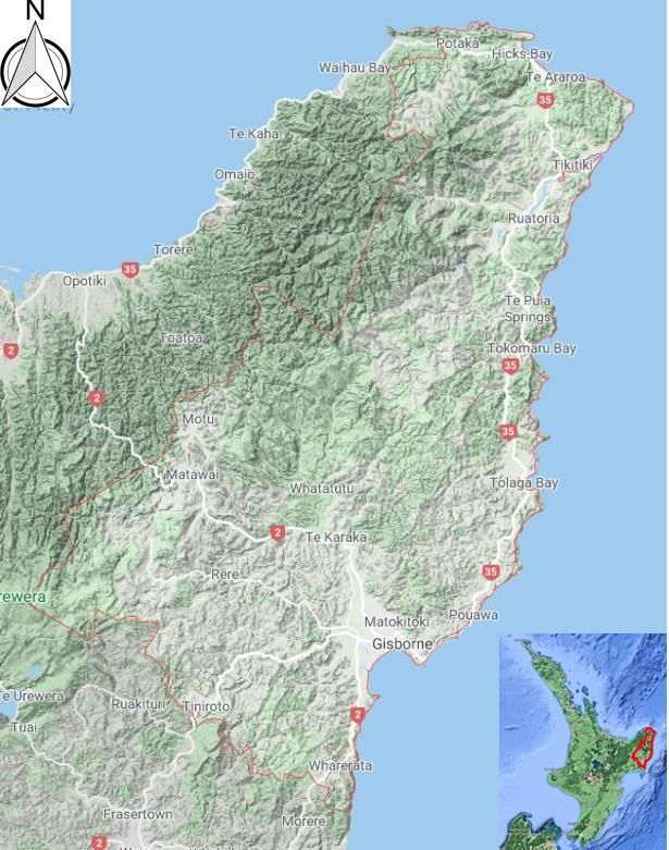
instability has also created areas of colluvium on the steep hillslopes which remain vulnerable to continued shallow instability. In
addition to the ground conditions, historic road formation practices (i.e. sidling cut and fill with minimal compaction) have also
created areas vulnerable to shallow slope instability. The interface of the fill with natural ground often becomes the shear surface for
shallow failures.

Figure 1 The Tairāwhiti Region (outlined in                Figure 2 Regional geology (source Mazengarb and
Red)(source google maps)                                   Speden 2000)

2     RAINFALL EVENTS COMPARED TO  CYCLONE BOLA
                               2000)
Figure 4 below presents a comparison of the significant peak rainfall events between April 2017 and September 2018 that resulted in
so much land damage to Tairāwhiti region. Cyclone Debbie (5 April 2017) produced 85 mm of rain over 16 hours and resulted in the
initial saturation of the regions soils. On 12 April 2017, Cyclone Cook hit the region with a peak intensity of 80 mm in 3 hours.
Whilst this was a relatively small storm its effects were exacerbated by the preceding Cyclone Debbie. In July 2017 (13-16 and 20-24
July 17) two storm events also impacted the region with peak rainfall of 50 and 80 mm respectively (Cave et al 2017).
The 3-4 June 2018 (Queens Birthday storm) produced a total 266 mm in 24 hours. This was a localised event impacting the Uawa
and Pakarae catchments. A second event over 11-12 June 2018 produced 224 mm in 24 hours. This was a region wide event and
resulted in flooding and land damage exacerbated by the earlier June event. Flood levels stayed above 9 m for 7 hours (GDC 2018).
Finally a rain event over 4-9 September 2018 resulted in a peak rainfall of 100 mm.

                                          PEAK RAINFALL BY EVENT
            RAINFALL PER 24 HOURS

                                          Mar-88    Apr-17           Jul-17         Jun-18           Sep-18

                                    500                      Cyclone
                                                             1st Peak, June                           2nd Peak, July
                                    400
                    (MM)

                                                              Cyclone                                 2nd Peak, June
                                    300                      September                                      Cyclone
                                    200                      1st Peak, July
                                    100
                                      0
                                          PEAK 1                                     PEAK 2

          Figure 3 Peak rainfall in 24 hours in 2017 and 2018 compared to Cyclone Bola

                                                                   2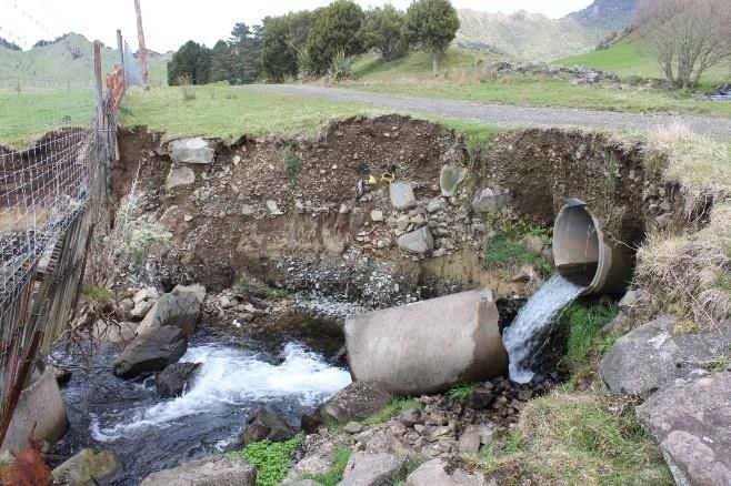
In March 1988 Cyclone Bola struck the East Coast causing widespread damage from land erosion, downstream flooding and
landslips. Damage estimates exceeded $220 million (Cave et al 2017). Bola had a devastating effect on the steep areas at river
headwaters that were in pasture or young forestry plantations. Land damage in areas with more mature forestry planting was 16 times
less than that of pasture and young forestry (Marden and Rowan 1994). McKelvey and Murton (1991) published on 40 landslide
damage sites on State Highway 35 in the Tairāwhiti region following Cyclone Bola. Over $15 million was spent to remediate these
40 sites. There is no other data available to understand the quantum of road damage to SH 2 or the local road network.
As a result of Bola the East Coast Forestry Project was initiated in 1992 with the intent of accelerating the rate of land use change to
plantation forestry. By 2016 it was estimated that 141,581 ha of land comprised exotic forest (Cave et al 2017). Harvesting of the
East Coast Forestry Project has already commenced with an expected peak in harvesting in the next 13 years (Cave et al 2017). We
have not had the data for a direct correlation between damage to the road and forestry activity land. However there is anecdotal
evidence that areas that have been harvested in the last 5 years have more localised slope failures and road damage. An example is
Tauwhareparae Road near Tologa Bay. In recent years, this area has been heavily deforested and it was the hardest hit road in the
region as a result of the 2017 and 2018 storm events. The road recorded over 360 faults from the June 2018 rain event alone.
Whilst the 2017 and 2018 rain events were not as significant in terms of rainfall intensity or flooding duration as the 1988 Cyclone
Bola event, the impact on the land, the roading network and the economy has been cumulatively just as significant.
3 DEVASTATION OF THE ROAD NETWORK
The combination of the rainfall events, steep slopes, saturated soils, recent logging of areas and logging debris created a “perfect
storm of circumstances” that resulted in over 5,000 recorded faults on the road network.
Figure 4 below indicates the quantum of sites repaired, evaluated and consented.
April 2017, July 2017, 5286
June 2018 & September Recorded
2018 Events Sites
Primary and Secondary 381
4905
Required
Response Completed
Investigation
182 79 Do 120 Require
Investigation Required Nothing Additional
Design More Funding
107
75 Resource
Planning Consents
Permitted
Activities
Figure 4 Summary of remedial actions
Primary and secondary response to these emergencies by the NOC contractor resulted in the majority of the sites being repaired with
minimal engineering design input. At the end of secondary response the remaining 381 sites required engineering assessment and
action decisions.
The repair of all the sites could not be made with the available funding and some sites were either classified as “do nothing” or
“requiring more funding”. All sites were assessed and 182 sites required investigation, design and consenting.
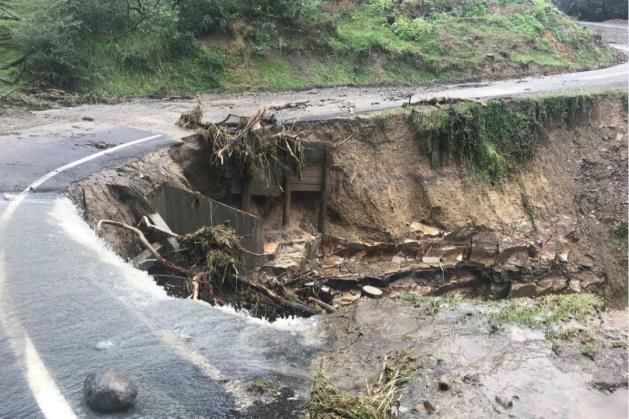
The types of failures on the roading network are summarised below and illustrated in Figure 5 below.
• Over slips – shallow failures of saturated soils on the uphill side of the road
• Under slips - small failures due to scour at culvert outlets
- scour of the downhill side of the road due to blocked culverts and table drain overtopping
- shallow failure due to saturation of sidling fills
• River bank scour generating loss of road carriageway, undermining bridge abutments
• Forestry scrag damage
• Hillside failures due to saturated conditions
3
Over slip at Waimata Valley Road, Gisborne Under slip at Armstrong Road, Whatatutu
Culvert outlet scour at Moutohora Road, Motu Under slip at Tarndale Road, Whatatutu
Scour due to culvert blockage and storm water runoff
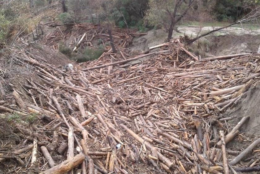
Forestry scrag damage at Paroa Road, Tolaga
at Arakihi Road, Tolaga
River bank scour at Tapuaeroa Road, Ruatoria Hillside failure at Waitahaia Road, Te Puia Springs
Figure 5 Examples of failure types on the Tairāwhiti roading network.
4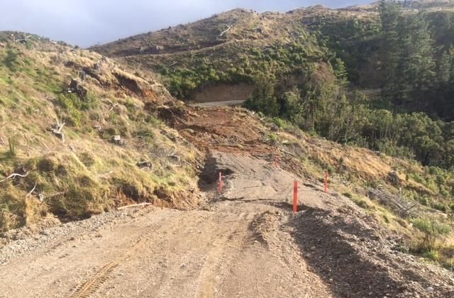
4     CONSULTANTS RESPONSE APPROACH
From a consultant’s perspective, we were asked to investigate, design and consent 381 sites in 16 months. From commencement of
the programme it was important to understand the level of serviceability the client wanted returned to the local roads, the clients risk
appetite and budget constraints. In collaboration, we determined that if a site had 1 m of shoulder, functioning drainage, no risk of
undercut or continued failure then a “make safe” or “do minimum” option was applied. Otherwise remedial solutions were identified
to create stable solutions to replace lost carriageway, establish 1 m of shoulder, add or fix drainage and provide safety features as
needed.
The client had a strong desire to make the available funding go as far as possible, thus no or minimal intrusive ground investigation
was completed. Except for larger road retreats, topographic survey was restricted to zip line, and laser level surveys to develop cross
sections to support ground model development and design. GDC accepted the resultant risk of unforeseen ground conditions, the
potential for design outcomes with lower life expectancy and the potential for standing time and design changes during construction,
To come to this decision the risks were weighed up against the need to have a functional network. An outcome of this approach is
that chosen geotechnical design parameters were deliberately conservative.
Borehole drilling or CPT’s were only undertaken for larger and more expensive remedial solutions such as high retaining walls or
where rock could not be located in hand augers. Mobilisation of investigation plant into the remote Tairāwhiti regions is expensive.
Drone survey was undertaken for larger road retreats. This was especially important to provide better quality geometrics to assist in
understanding if private land was affected and to calculate the areas of land disturbance to support consenting.
As we have shown earlier in this paper, the landscape and the roading network of the Tairāwhiti Region is both challenging and
relatively fragile. Historically, it has been impacted by a number of flood and rainfall events and may well be subject to seismic
activity in the future. Given the size of the roading network and the limited available funding, the road operators have a realistic
expectation around the level of resilience that they expect to achieve. For the flood damage repairs, we collaboratively developed a
design philosophy which met the clients higher risk appetite and their desire to agree to variations to the design guidance in the
NZTA Bridge Manual (2018) requirements. This preference included a 15 year design life, no or minimal seismic design, and larger
accepted deformations. Developing this fundamental understanding of the client requirements and basis for design provided a clear
pathway of expectations and next steps for the assessment and design teams.
Assessment teams were sent across the region based on an agreed road priority basis. Roads considered to be key access routes, or to
have significant importance to the economy such as logging routes were given higher priority. The dedicated assessment teams
comprised a geotechnical engineer or an engineering geologist paired with a civil/roading engineer. They were located in the region
for 1 week in every 4. These pairings allowed for a pragmatic and holistic approach to the remedial outcomes such that the failure
cause was identified, usually storm water related, and allowed for sufficient geotechnical and topographic sections to be collected to
support design. Depending on the complexities of the sites and their location, an assessment team could visit and collect data for up
to 35 sites in a week and present a summary of remedial solutions to the client on the last day. These client presentations worked well
for the less complex sites. We presented the cause of the failure, a range of likely solutions with likely costs and advantages and
disadvantages. In collaboration with the client we agreed a design option for each site before the assessment team demobilised from
Gisborne. All parties agreed that this was innovative and cost effective.
For all the sites that required assessment and design, a bespoke design was generated. Some were as simple as drainage works,
pavement repairs and minor retreats marked up onto site photos. However, the complex over slips, under slips, river and culvert
scours required detailed design solutions.
Typical design solutions for these sites included:-

     •    Timber or steel pole retaining walls with/without                   •    Reinforced soil slopes
          anchors
                                                                              •    Mechanically stabilised earth structures
     •    Retreats
Other design solutions such as rock buttressing, gabion baskets, mass block walls were consider at the early stages of the works.
However, local and regional constraints such as excessive cost of quality rock, limited availability of material suitable for gabions,
long lead times for concrete block production, long cartage distances and limited number of capable contractors ruled out a number
of these options.
For the complex sites, the one size fits all design approach does not work as there are just too many influencing variables. So specific
design was completed for each site. To deliver the volume of work and sites, a dedicated team of 21 completed the design and
consenting packages. The deliverables for every site included detailed design drawings, supporting design memo, schedule of
quantities suitable for contractor pricing, safety in design register, consent assessment, and in some cases consent application.
Examples of the types of construction outcomes are presented below in Figure 6.

                                                                   5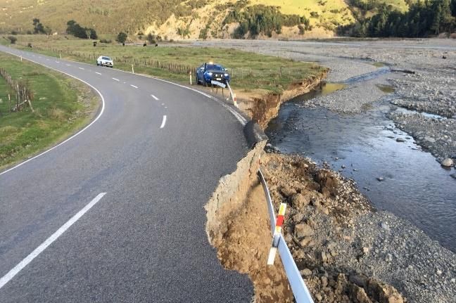
Accelerating the design consenting programme, wherever possible, was required to ensure that there was a steady flow of sites
available for construction and that the funding cash flow could be properly managed.

Timber retaining wall at                     Reinforced slope at Waikura                   MSE wall at Arakihi Road RP
Armstrong Road RP 2.557                      Road RP 15.979                                0.125
Figure 6 Examples of completed remedial works.
In tandem with the design process, a planning assessment of the proposed works was made to determine if the proposed works are
either a permitted activity or required a specific consent. The Tairāwhiti District plan is complex and was developed after Cyclone
Bola to support minimal land disturbance in areas with steep slopes. Whilst it gives due consideration to slope angles, soil types and
erosion susceptibility it is very restrictive on the quantum of land disturbance that can be undertaken. All remedial works including
dumping of excavated waste and landslip spoil must meet the Plan requirements. Early planning assessment based on the indicative
remedial solution and land disturbance areas enabled consent to be prepared in parallel with the design and lodged upon design
completion.
To expedite consenting and minimise work for both the applicant’s planners and the council consenting team, clustered consents
were used wherever possible. The choice of multiple sites in one application were based on land overlay, location or similar type of
works.

5     OVERCOMING KEY CHALLENGES
There were a number of key challenges that had to be overcome to ensure successful delivery of this programme of works. These
included changing client priorities, changing client organisations, managing the high risk low cost outcomes, delivering design and
consenting so as to not hold up construction, understanding the limited product options and construction resources in Tairāwhiti, cost
efficient use of out of region geologists and engineers and limited understanding of the District Plan rules.
In the early stages of the programme, there were multiple changes in priorities for construction and funding that meant that the
construction programme did not always match the design/consenting programme. The number of sites being released into the
programme for design and consenting was not sufficient to maintain a dedicated engineering/planning team and keep several
construction crews running. This created frustration for all parties involved and did not result in a collaborative team or environment.
With surety of funding a clear set of roading priorities and a clear delivery time line was developed which allowed a more consistent
work flow. A programme was developed which allowed for “geos” to be on site for a week in every four, provided clear deadlines
for design and consenting and allowed the Contractors to have a clear work flow for pricing and construction.
High risk low cost design with minimal site investigation is not something most geotechnical engineers prefer to do. We are all
trained to follow the published guidance and standards. For this project it was important to develop a clear design philosophy and risk
profile as early as possible and communicate the associated risk to the client. It is also important to bring the Designers on this
journey so that overly conservative and expensive designs do not result due to the lack of site specific ground condition data. On site
validation of the ground conditions during construction can manage the associated risks. To mitigate some of this risk and enable
prompt decisions around design changes for unforeseen ground conditions, a toolbox has been developed. This toolbox addresses
unexpected soft soil up to 4m deep in the foundations of bench and fill, reinforced fill slopes or MSE walls. It takes the engineer
through a set of steps to collect on soft soil depth, down slope angles and combined with known design height and design slope angle
it either identifies the most suitable foundation remediation option or refers the site engineer back to the designer. This innovative
toolbox has saved thousands of dollars in contractor standing time and expensive redesign.
Developing a successful collaborative environment where an accelerated programme and cost effective design is required takes
effort. Having two dedicated flood damage staff embedded in the Gisborne NOC Contractors offices and working with all parties
resulted was a big contributor to the success of this collaborative approach to delivery. Constructors shared their understanding of
product restrictions and limitations, and constructability challenges which resulted in fit for purpose designs. With the development

                                                                   6
of the clear work flow and work programmes, cost efficiencies were gained especially with the site assessment teams and the
development of a dedicated design and consenting team.
The GDC District plan is very complex and there is a lack of understanding of the planning rules by the people on the ground doing
the work. This can result in construction being done without consents, lack of environmental compliance, dumping of spoil, and lack
of trust by the Council consenting and compliance teams. The flood damage planning team worked hard to clearly define “permitted”
activities and identify sites that could go for immediate construction. The team also developed the “clustered” consent approach to
limit the quantum of consent applications and the time required by the Council consent processing team. The biggest success,
however, was the improvement of environmental compliance by the Contractors. This was achieved with the development of
permitted activity sheets which clearly indicated what was allowed and provided guidance on erosion and sediment control measures
and related activities. These sheets coupled with specific contractor education sessions markedly increased the level of understanding
and compliance.

6     LESSONS LEARNT
Delivering a design and consenting programme of hundreds of small sites in a tight time frame comes with many challenges.
Retrospect allows us to take stock and look at what we have learnt, what works what doesn’t work and share this with the technical
community. The list below is a brief summary of the lessons learnt, most of these have been discussed above.

     •    Document the clients risk appetite and the resultant design philosophy very early in the project. Ensure this is
          communicated to the whole team in order to prevent misunderstandings and the need for rework;

     •    Building knowledge and consistency in approach. The best delivery outcomes for both site assessment, design and
          consenting was when we had a consistent team of people on the job;

     •    Having dedicated senior staff in Gisborne for a significant duration made the team readily available to client and contractor
          alike, developed the trusted relationship and provided agility to manage programme and approach changes;

     •    Working collaboratively with contractor, client, planners and designers and consenting authority resulted in a very positive
          delivery outcome and award winning client service;

     •    Pairing civil and geotechnical engineers together for the assessments resulted in better design solutions: - outcomes that
          dealt with storm water as well as the geotechnical concerns;

     •    Gaining the client’s confidence and developing a limited gateway approval process to keep work packages flowing;

     •    Looking for time efficiencies in design and consenting. e.g. Design directly on to photos for simple sites and use clustered
          consenting

     •    Add value where ever possible to support the collaborative environment. Examples included education of contractors on
          permitted activity standards; development of a costing tool for the site assessment team to price remedial options quickly;
          identifying alternate product that could be used for earthworks; and developing a tool box to deal with unforeseen
          foundation conditions for bench and fill and MSE slope options.

7     CONCLUSION
The impact of five storm events resulted in widespread damage to the Tairāwhiti roading network. Whilst these storms did not have
the same rainfall intensity as the infamous 1988 Cyclone Bola, cumulative damage has been equally significant. Post Bola, forestry
plantations were used to stabilise the region. Harvesting of these forests has been underway for the last five years. There is anecdotal
evidence that recent deforestation has increased road failure rates and damage to the roading network.
To deliver a remediation programme in a tight time frame, a strong understanding of the client’s risk appetite, budget and required
level of service was developed early. It meant we were able to collaboratively develop a design philosophy to meet their expectations
and, in this case, higher risk appetite and cost effective outcomes. Pairing geotechnical and storm water/civil professionals provided
an innovative approach to site assessments which allowed for pragmatic and holistic remedial outcomes, cost effective site data
collection and fast track design solutions.
Collaboration brings about innovation. In this case, costing tools and soft soil foundation toolboxes were developed and the
consenting team developed a “clustered” approach to resource consent applications to reduce the time required for Council
processing. Contractors were given guidance and training to improve environmental compliance. The outcome to date has been full
environmental compliance.
These storm events will not be the last to hit the region and by developing tools and systems and working collaboratively the NOC
contractor and GDC will be able to respond to future events with promptly and prepare better funding applications.

                                                                   7
8    REFERENCES
Cave, M.; Davies, N; Langford, J. 2017. Cyclone Cook Slash Investigation, Gisborne District Council
Gisborne District Council. 2018. Key Findings – Analyses of Hydrological and Rainfall Data June Storms (Queens Birthday 3-4 June
   and 11-12 June 2018 storms). GDC internal memo.
Marden, M.; Rowan, D. 1993. Protective Value of Vegetation on Tertiary Terrain Before and During Cyclone Bola, East Coast, North
   Island , New Zealand, New Zealand Journal of Forestry Science, Vol 23(3) 255-263
Mazengarb, C.; Speden, I.G. (compilers) 2000. Geology of the Raukumara area: scale 1:250,000. Lower Hutt: Institute of Geological
   & Nuclear Sciences Limited. Institute of Geological & Nuclear Sciences 1:250,000 geological map 6. 60 p. + 1 folded map
McKelvey, R.J; Murton, K. 1991. Landslide Damage on the East Coast Region Arising from Tropical Cyclone Bola, March 1988.
  Landslides, Bell (ed) Balkema Vol 1 1445-1450
NZ Transport Agency. 2018. Bridge Manual SP/M/022. Third edition Amendment 3

9    ACKNOWLEDGEMENTS
The information presented in this paper was obtained from the collaborative work of GHD, Downer, and Gisborne District Council.
The authors which to thank Gisborne District Council and Downer for constructive review and permission to publish this paper. We
also thank the GHD team, too many to name individually, who assessed, designed and consented so many sites in a year and to the
GHD Gisborne office for hosting the Flood team and putting up with vehicle swapping, geotech equipment and PPE bags under all
the desks when there was no other storage.
Finally we acknowledge GHD management for recognising this project as a great example of client service and awarding the GHD
2020 APAC Client Service Award to this team.

                                                                8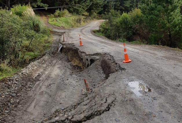
You can also read