Overall Observing Strategy in AMMA 1 A brief reminder of the AMMA Scientific objectives
←
→
Page content transcription
If your browser does not render page correctly, please read the page content below
Introduction, Version 2.2, 23 March 2006

                                            Chapter 1
                    Overall Observing Strategy in AMMA

1 A brief reminder of the AMMA Scientific objectives
       The three overarching goals of AMMA, as given in the AMMA International Science Plan (ISP)
are:
      (1) To improve our understanding of the WAM and its influence on the physical, chemical and
biological environment regionally and globally;
      (2) To provide the underpinning science that relates climate variability to issues of health, water
resources, food security and demography for West African nations and defining relevant monitoring
and prediction strategies;
      (3) To ensure that the multidisciplinary research is effectively integrated with prediction and
decision making activity.
      A detailed description of all the interlaced scientific questions deriving from the above overall
objectives is given in the ISP. The ambition of the programme is both to improve our understanding of
the numerous processes that are the skeleton of the WAM and to gain a new knowledge on how these
processes interact to form a climatic system, characterised by a great interannual and decadal
variability. The consequences of this variability for the population are huge. Unreliable rainfall, poor
predicting capacity, rapid modification of the environment combine to produce harsh agricultural
conditions and to threaten the success of development policies.
       The AMMA observing program reflects the complexity of its scientific agenda. While
individual processes are often spanning a limited range of scales, documenting them all, as well as
their interactions, requires a specific observing program covering a broad range of relevant scales,
from regional to local. Factors originating outside of the study area have been demonstrated to interfer
with the WAM, which draws attention towards the global scale. Impact of the WAM variability on
population is felt at the scale of the field plot, which means studying how the regional scale variability
is transferred to the local scale.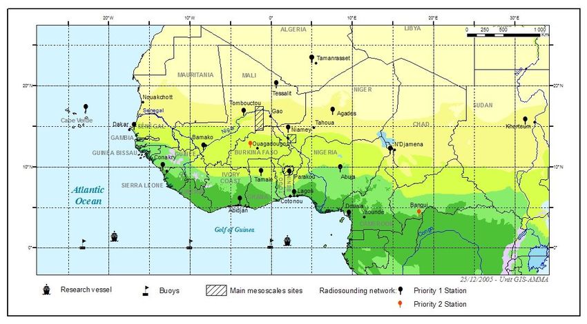
Overall AMMA Strategy                              -1.2-

2 Space and time scales of the AMMA observing program
      In order to elaborate a coherent observing strategy and to take into account the multi-scale
nature of the various components of the West African monsoon, the observing strategy of AMMA is
built around a combination of different study areas and observing periods. These are designed to
sample the main space and time scales of interest to AMMA.

   2.1 Space scales and study areas
     Four main interacting spatial scales are identified, as illustrated in Figure 1.1 above :
     (i)    Global scale. This is the scale at which the WAM interacts with the rest of the globe;
            emphasis is given to improving our understanding of the role of global SST patterns on
            WAM variability; seasonal-to-decadal variability are the main time scales of interest. On
            this scale we are also concerned with the impacts of chemical and aerosol emissions from
            the monsoon system on the entire global climate.
     (ii)   Regional scale. This is the scale at which emphasis is given to improving our
            understanding of the interactions between the atmosphere, land and tropical Atlantic
            ocean (especially the Gulf of Guinea). It is important to study the role of surface
            feedbacks on variability of the WAM at this scale, including the key roles of vegetation
            and soil moisture over the continent and SSTs in the Gulf of Guinea. African Easterly
            Waves (AEWs) and other synoptic systems are also studied at this scale. This scale
            corresponds to a window larger than the one shown in Figure 1.1; it includes a larger
            portion of the Ocean to the West and to the South, extends North to the Heat Low
            (sounding stations in Tessalit and Tamanrasset) and East to Soudan (sounding station in
            Khartoum).
     (iii) Mesoscale. This is the scale of the typical rain-producing weather systems in the WAM. It
           is central for studying the variability of rainfields at the seasonal scale and the coupling
           between hydrology and the atmosphere at the catchment scale. It is important to study the
           interactions of the mesoscale weather systems with synoptic scales (e.g. AEWs). In Figure
           1.1, this scale is illustrated by the Ouémé catchment (14600 km²).
     (iv)   Local scale or sub-meso scale. From an atmospheric point of view, this is the convective
            rain scale, of a few kilometres; it is central to the hydrology of the Sahel and of small
            watersheds to the south; it is the main scale of interest for agriculture. In Figure 1.1, this
            scale is illustrated by the Donga catchment (576 km²)
      AMMA emphasizes the importance of improved understanding of how these scales interact and
combine to characterize the WAM and its variability, including how these interactions impact sources
and transport of water vapour, aerosol and key chemical species (e.g. key greenhouse gases, ozone and
aerosol precursors) in the West African region and globally.

                               AMMA International Implementation Plan – Version 2.2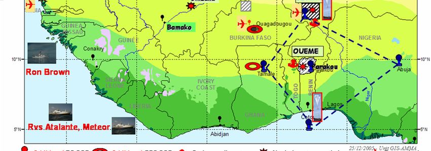
-1.3-                                                    Overall AMMA Strategy

Fig 1.1. The regional scale AMMA study area. The radiosounding stations on the continent and the PIRATA buoys are the primary source of in situ information at that scale, in
addition to the observations of the meteorological and hydrological operational networks.

AMMA International Implementation Plan – Version 2.2                                                                                                           -1.3-
Overall AMMA Strategy                               -1.4-

Fig 1.2. The long term AMMA observations on the continent. On the continent, the regional scale is monitored
both through operational networks and specific networks (PHOTON, IDAF for aerosols and wet/dry deposits). The
three mesoscale areas (Gourma, Niamey, Ouémé) include so-called super-sites and intensive local sites (as shown
by the zoom on the Ouémé catchment). Another mesoscale site is the Nakambé catchment in Burkina-Faso.

   2.2 Time scales and periods of study
       Three periods of study are considered in order to sample the interannual variability and the
intraseasonal variability as well as to be able to properly document the mean seasonal cycle, and possible

                                AMMA International Implementation Plan – Version 2.2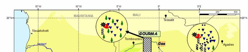
-1.5-                     Overall AMMA Strategy
decadal scale trends. These three periods are the Long term Observing Period (LOP: 2001-2010), the
Enhanced Observing Period (EOP: 2005-2007) and the Special Observing Period (SOP: 2006).

       2.2.1 LOP
      Given the great variability of climatic conditions from year to year, observations are needed over
several annual cycles in order to gain a proper vision of the diversity of the seasonal cycles, around a
mean state which is only a statistical concept, but is never observed as such. The operational networks are
precisely intended at this type of monitoring. However, operational networks are not dense enough to
sample properly the spatial scales of interest when studying the links between the climate, the water cycle
and the vegetation dynamics at the intrasesonal scales. Rainfall for instance has been shown to be
extremely variable in space over the Sahel with characteristics scales in the order of 20-30 km, event
when considering accumulation over the whole rainy season. It stems from this that the operational
networks cannot sample the great variability of the seasonal rainfields and that the global rainfall indices
supposed to characterise the rainy season are giving an oversimplified image of what the rainy season is.
Since many other climatic and environmental variables are dependent on rainfall, this mere fact
underlines how important it is to densify, at least locally, the operational networks. Moreover the
operational networks of West-Africa are not in an homogeneous state of maintenance and reliability all
over the region. For this decadal scale documentation of the climate and the environment AMMA is thus
relying on specific observing systems that do not cover the whole region but provide a sampling of the
main eco-climatic conditions encountered in West Africa (Fig 1.2). These systems are part of the
Observatoires de Recherche en Environnement (ORE) program setup by the French ministry of Research.
Five such OREs (2 over the ocean, 3 over the continent) were specifically setup in 2001, building on
previous observations, some of which started as far back as the 1980's.

                                                                                     Special Observing
                                                                                     Period

                                                                                          Specific
                                                                                          measurements for
                                                                                          the EOP
   ORE + Operational
   networks                                                                              Post-EOP

                                                       LOP
Fig 1.2. The AMMA observing periods.

Table 1.1. Parameters measured by the 5 OREs covering the AMMA region since the early 2000's.

            ORE Name                            Parameters                                Instruments
              PIRATA                      Ocean-atmosphere Fluxes                        10 Atlas Buoys
  http://www.brest.ird.fr/pirata/
                 SSS                        Sea Surface Salinity       XBTs and Thermo-Salinographs, since 2003, along
  http://www.brest.ird.fr/sss/salinit1.                                             commercial routes.
  html
              CATCH                        Hydrology, Vegetation         3 mesoscale sites (Gourma, Niamey, Ouémé):
  http://www.lthe.hmg.inpg.fr/catch/

                                           AMMA International Implementation Plan – Version 2.2
Overall AMMA Strategy                              -1.6-
                                                               observations from the mid-1980's and the 1990's.
                                                                Increased density of measurements from 2001.
       IDAF (DEBITS)           Atmospheric Deposits        5 stations in the AMMA region. First installed in 1993.
   PHOTONS (AERONET)                Aerosols                     8 stations from 2001, 2 additional from 2005

      Oceanic OREs (see also maps in Chapter 8, TT6).
     PIRATA (http://www.brest.ird.fr/pirata/piratafr.html), 10 atlas buoys in the Atlantic Ocean; 5 are
managed by IRD, located at 23°W-0°N, 10°W-0°N, 0°E-0°N, 10°W-6°S and 10°W -10°S; 5 are managed
by Brazil, located at 35°W-0°N, 38°W-4°N, 38°W-8°N, 38°W - 12°N and 38°W-15°N.
       SSS (Sea Surface Salinity). Based on data provided by commercial ships, this ORE monitors sea
profile temperatures (XBT) and sea surface salinity (http://www.brest.ird.fr/sss/salinit1.html and
http://www.brest.ird.fr/xbt/xbtorst.html).
       Other oceanic international programs of interest to AMMA include the surface drift buoys (SVP)
recording SSTs in the framework of the GOOS Global Drift Programme (http://www.aoml.noaa.
gov/phod/dac/gcd.html) and the deep drift buoys (PROVOR) providing every 10 days profiles of
temperature and salinity in the framework of the ARGO program and its French component CORIOLIS
(http://www.ifremer.fr/coriolis/).
      Continental OREs.
      CATCH: An ensemble of three sites (see Fig. 1.1) devoted to studying the hydrological cycle from
the local to the mesoscale and to its coupling with the vegetation dynamics. The three sites are: Gourma a
25000 km² area in Mali (2°W-1°W; 14°30'N-17°30'N), CATCH-Niamey a 16000 km² area in Niger
(1°40'E-3°E; 13°N-14°N), Ouémé a 14600 km² catchment in Bénin (1°30'E-2°45'E; 9°N-10°10'N). On
Gourma the emphasis is on the vegetation studies with the aim of regional modelling of its dynamics. The
two other sites are densely instrumented in hydrological measurements (detailed maps in chapters 5, 6, 7).
    IDAF: A network of 5 stations documenting the atmospheric deposits; 3 are installed on each of the
CATCH super-site, and 2 are sampling the forest areas (Zoétélé in Cameroon and Lamto in Ivory Coast).
       PHOTONS (http://www-loa.univ-lille1.fr/photons/). A transect of 4 Sahelian stations Sal, M'Bour,
Ouagadougou, Illorin, plus a station in Morocco (Dakhla), plus one station on each of the CATCH super-
site, that is a total of 8 stations. Note that in 2005, a photometer was installed in Cinzana (Mali) and one
in Maine Soroa (East Niger), thus enlarging and densifying the Sahelian transect for the 2005-2010
period. Further details may be found in Chapter 4 (TT2b)
      Other long term programs of interest to AMMA over the continent include the German GLOWA
projects (GLOWA-Impetus on the Ouémé catchment and GLOWA-Volta on the Volta catchment in
Burkina-Faso and Ghana), and the Burkina EIER/INRAB Nakambe catchment.
      The LOP also involves atmospheric monitoring on the routine synoptic and upper air networks of
the region (sounding stations shown in Figure 1.1). Some stations in the region have long and successful
climate records, and must be sustained throughout the period, both for direct climatic analysis and to
provide consistency in the atmospheric analyses (e.g. ECMWF reanalyses) in which they are assimilated.

      2.2.2 EOP
      The Enhanced Observing Period (EOP) is designed for a detailed documentation of the annual
cycle of the surface and atmospheric parameters for convective to synoptic scales. As such it builds upon
the LOP setup and its mesoscale sites strategy associated with a regional monitoring. The enhancement of
observations over the mesoscale sites is done at two levels: i) a spatial densification of existing
measurements and ii) the installation of instruments allowing for the measurement of variables not
observed during the LOP, because these instruments are too costly to operate over such a long period. The
regional coverage is obtained through various actions: i) a restoration and upgrade of the radiosounding

                               AMMA International Implementation Plan – Version 2.2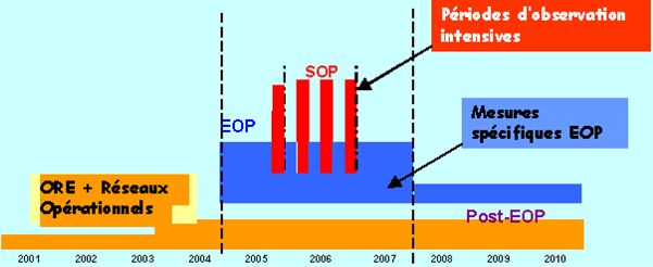
-1.7- Overall AMMA Strategy
network operated by ASECNA and national meteorological services; ii) installation of specific new
instruments deployed in networks. Added to this continental deployment are oceanic measurements
carried out by a research vessel during two annual cruises: one in June and one in September of each EOP
year.
As shown in Figure 1.2, some specific EOP instruments will remain in operation after the end of
the EOP, which means that there will be more instruments in operation during the post-EOP LOP than
during the preliminary 2001-2004 period.
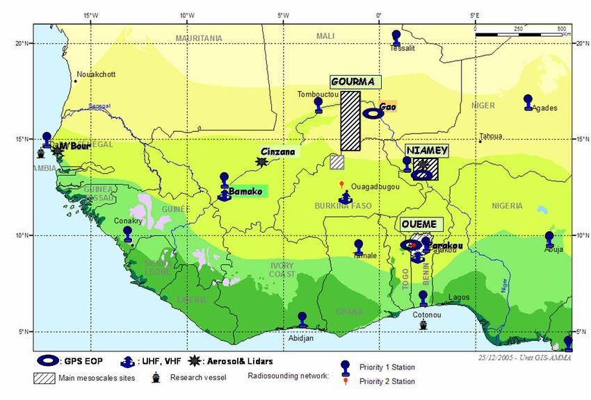
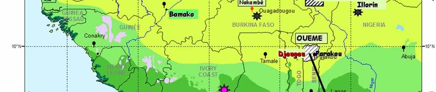
Fig 1.3. The EOP regional observing system on the continent.
2.2.3 SOP
The Special Observing Period, in 2006, focus on the study of processes specific of the main phases
of one monsoon cycle, that is: i) the dry phase (phase 0) lasting from November to February; ii) the onset
phase (phase 1) leading to the monsoon jump (end of June); iii) the well developed monsoon (phase 2:
peak of the rainy season over the Sahel, and little dry season on the coast) from the end of June to mid-
September; iv) the period most favourable for the tropical cyclogenesis over the Atlantic, lasting from
mid-August to mid-October. This latter period is not a monsoon phase per se and it overlaps phase 2. It
was identified as a separate period (3) because of a specific interest for the Atlantic tropical cyclones that
hit the Caribbean and the South-Eastern coast of the USA; phase 3 is also of interest in certain aspects of
the aerosol export westwards over the Atlantic. While phases 0, 1 and 2 correspond to well defined
regional climatic patterns their exact time frame obviously varies from year to year. Now, the heavy SOP
deployment (aircraft and balloons) cannot cover continuously the entire year; thus only a limited part of
each phase will be documented by the full SOP setup. These sub-periods are called SOP0, SOP1, SOP2
AMMA International Implementation Plan – Version 2.2Overall AMMA Strategy -1.8-
and SOP3 as shown in Figure 1.4. A number of different platforms and instruments will be deployed in
these sub-periods, in different characteristic modes according to their needs and scientific outputs.
Some EOP ground-based networks will be enhanced regionally for a large part of the SOP year –
for instance the GPS network and lidar networks will be enhanced in this period. At the same time new
ground-based systems will be installed for the SOP year: as an example, the ARM Mobile Facility (AMF)
is now installed at Niamey and will operate until 31 December 2006. Other ground-based systems will be
installed for sub-periods, according to their scientific priorities (e.g. radars to target precipitation systems
in the rainy months of SOP1 and SOP2).
Ships, balloons and aircraft, whose deployments are by necessity relatively short, will be
coordinated with the ground-based deployments for specific parts of the SOPs, as illustrated in Fig. 1.5.
Within a given SOP, specific aircraft campaigns are defined with a suffix ‘_a1’, ‘_a2’ or ‘_a3’, so that,
for example, the second phase of aircraft activity in SOP2, at which we aim to deploy 5 research aircraft
in cooperation, is denoted SOP2_a2. The detailed coordination of these instruments is elaborated later in
this Implementation Plan.
AMMA SOP Year: 2006
Atlantic cyclogenesis
Monsoon Phases 0 : Dry Season Transition 1: Pre ONSET Transit. 2: Post ONSET Retreat of the ITCZ 0
January February March April May June July August September October November December
SOP0_a3?
SOP2_a2
SOP0_a1
SOP0_a2
SOP2_a1
SOP2_a3
SOP1_a
AMMA SOPs
SOP0 SOP1 SOP2
SOP3
SOP3_a1
SOP3_a2
SO
SO
Fig 1.4. The SOP sub-periods
AMMA International Implementation Plan – Version 2.2-1.9- Overall AMMA Strategy
Fig 1.5. The SOP regional observing system. Instruments displayed in red are specifically deployed for the SOP.
Note however that not all SOP instruments will be in operation for the whole 2006 year, the deployment of some
instruments being limited to a single SOP (see SOP chapters 9 to 11 for details).
3 Presentation of the main AMMA entities
The implementation of the AMMA field programme is coordinated by the International
Coordination and Implementation Group (ICIG). This group reports to the ISSC, and is responsible for
coordinating the diverse needs of the science teams and instrument teams within AMMA. Given the
broad timescales, spatial scales and multidisciplinarity of AMMA, the ICIG has chosen to structure the
implementation according to temporal scale, LOP, EOP and SOP as defined above. Following this
approach, the implementation is being coordinated by teams whose shared objectives lie in these scales.
These teams are termed ‘Task Teams,’ and their remit has been to define coordinated deployment
strategies for sets of instruments with shared objectives. There are certain principles which underlie this
choice of management structure for the implementation:
• AMMA is a multidimensional and multidisciplinary programme, and it is imperative that
communication between Task Teams, and an effective overall vision of the implementation is not
lost. It is the role of the ICIG, reporting to the ISSC, to hold this integrative vision of the
programme.
• Every instrument is managed by at least one Task Team.
• Some instruments with different modes of activity (e.g. radiosondes) may be managed by more
than one Task Team.
• The work of the task teams is a continuous process of refinement of strategy, which will evolve
during the months leading to the actual deployment, and which includes ‘responsive’ strategy
AMMA International Implementation Plan – Version 2.2Overall AMMA Strategy -1.10-
during the deployment (for instance, the SOP Task Teams are responsible for flight-planning).
However, the work of the Task Teams is time-limited: following the respective periods of
deployment, the Task Teams will not be required and the responsibility for coordination of data
use will lie with the AMMA Working Groups (WGs), which report to the ISSC.
Table 1.2. The AMMA task teams
TT# TT Name Time and Space Scales Type of sampling
TT1 EOP Sounding of the EOP; Regional Homogeneous over the whole
Atmosphere sub-continent, plus transects
TT2a EOP Surface Flux Measurements EOP; Regional to local scale Concentration on meso-scale
sites, plus station to the South
TT2b EOP/LOP Aerosols Monitoring LOP/EOP; Regional Sahelian transect & Super-sites
and radiation
TT3 EOP/LOP integrative studies on LOP/EOP; Mesoscale to local 1x1 km² "plots" distributed all
the Gourma meso-scale site scale over the study area
TT4 EOP/LOP integrative studies on LOP/EOP; Mesoscale to local Homogeneous sampling at the
the Niamey meso-scale site scale mesoscale with denser
networks on a super-site
TT5 EOP/LOP integrative studies on LOP/EOP; Mesoscale to local As in TT4, except for one
the Ouémé meso-scale site scale additional minor super site
TT6 EOP/SOP Oceanic campaigns & EOP/SOP; Regional (Ocean) Cruises following "rails".
measurements in open ocean
TT7 Dry season SOP SOP; Regional to mesoscale Intensive observations using
aircraft & ground instruments
TT8 Wet season SOP SOP; Regional to mesoscale Intensive observations using
aircraft, balloons & ground.
TT9 Downstream SOP SOP; Regional/ Downstream Intensive observations using
aircraft, & ground instruments
In addition to the AMMA Task Teams, certain ‘Support Teams’ (STs) have been defined, in areas
where an aspect of the implementation crosses the temporal and disciplinary boundaries of the Task
Teams (e.g. ST3, the database team).
It should be made clear that support teams do not provide resources for AMMA scientists, but exist
as a coordination tool for different groups with similar needs. For example, ST2 (SOP Logistics) exists as
a forum between the numerous groups who are coordinating the logistical needs of instruments in Africa,
so that resources can be shared and good practice can be disseminated.
Table 1.3. The AMMA support teams
ST# ST Name Function
ST1 EOP logistics Inventories and synthesises the EOP TTs needs and interacts with the
AMMA Operation Centre to determine how these needs can be satisfied.
Evaluate the associated cost and human resources.
ST2 SOP logistics Inventories and synthesises the SOP TTs needs and interacts with the
AMMA Operation Centre to determine how these needs can be satisfied.
Evaluate the associated cost and human resources.
ST3 Data base Meta data base, data base, data policy.
ST4 Fund raising, capacity In charge of raising funds for AMMA-Africa, making AMMA known to
building and training international funding agencies and program with the aim of attracting
funding to the African institutions and scientists involved in AMMA.
Organises summer schools, training sessions, field schools, workshops.
Centralises opportunities for training in University programs in Europe
or USA.
AMMA International Implementation Plan – Version 2.2-1.11- Overall AMMA Strategy
4 Sites and Instruments.
The AMMA field program relies on operational networks and on instruments specifically deployed
on various sites for periods of varying duration, as described above. In this section we first provide an
overview of the sites (see also maps 1.1, 1.3 and 1.5) and platforms on which instruments are deployed;
then two tables summarise the instruments in operation during the three main AMMA periods. More
details can be found in the TT chapters and in appendix.
4.1 Sites and Platforms
4.1.1 Ground Sites
Table 1.4. The regional scale windows and transects
Name Position Description Periods of
activity
Continental 4°N -21°N; 18°W-10°E The whole continental area of interest. The monitoring is 2001-2004
Regional based on the operational networks (Radio-sounding stations, 2005-2007
Window Synoptic stations, Raingauge national networks). IDAF and 2008-2010
PHOTONS networks*. Remote sensing plays a major role.
Sub- Regional 5°N -18°N; 0-4°E + Includes the three main mesoscale sites, plus the ancillary 2001-2008
Window 11°N -18°N; 2°W-0° sites of the Nakambe and Dano in Burkina Faso.
780,000 km²
Sahelian M'Bour, Cinzana, Aerosol (3 stations) studies during EOP and post EOP; 2005-2007
Transect Banizoumbou Convective systems studies (radars during SOP), including 2008- ?
their role in dust transport 2006
Water Budget Cotonou, Tamale, Water budget closure studies during the SOP year 2006
Quadrilateral Niamey, Abuja
South
* Note that the IDAF network extends to Zoetele 3°N,11°E (Cameroun) and PHOTONS include one station in Morocco.
Table 1.5. The mesoscale sites
Name Position Description Period of
activity
Ouémé Bénin; 9°-10°N; 1.5°-3°E Densely instrumented catchment with denser instrumentation on sub- 1997-2007
catchments (Donga, Aguima, Ara).
Catchment 14200 km² Soudanian climate (different types of rain systems) and Savannah
+ post EOP
vegetation. monitoring
Global models; impact of climate variability on water resources.
Niamey Niger; 13°-14°N; 1.6°-3°E The survey of the “Niamey square degree” started in 1990. Heavy 1990-2008
observations in 1992, monitoring from 1994 to 2002, densification
meso-site / 16000 km² / starting again in 2003.
+ post EOP
Kori de Catchment in the North-East of Sahelian climate with semi-arid vegetation (Millet crops, Tiger bush,…). monitoring
Dantiandou Niamey meso-site 5800 km² Long series of high resolution rain data and groundwater levels.
Gourma Mali; 14.5°-17.5°N; 2°-1°W Sahelian to saharo-sahelian climate (between isohyets 400 and 100 mm). 1984-2008
Semi-arid natural vegetation composed of annual grasses and a sparse
30000 km² tree layer. Crops only present in the southern part of the area. 16
+ post EOP
vegetation sites monitored since 1984. Also satellite products validation monitoring
sites (vegetation, soil moisture).
Nakambé Burkina; 14.1°-10.9°N; Sahelian climate (between isohyets 400 and 100 mm). Semi-arid natural 2004-2009
vegetation. Hydrological monitoring, erosion studies.
2.5°-0.1°W; 40836 km²
Table 1.6. Super sites
Name Position Description Period of
activity
Donga Bénin; 9.6°-9.9°N; 1.6°-2°E Sub-catchment of the Ouémé catchment with a dense recording 2002-2008
raingauge network (14 stations) and 5 streamflow stations. Land surface
Catchment 590 km² process studies, hydrological modelling, coupling with the sub-surface
+ post EOP
and the atmosphere. monitoring
Aguima Bénin; 9.10°-9.14°N; 1.9°- Sub-catchment of the Ouémé catchment, with a dense recording 2001-2008
raingauge network (9 stations, some are in neighbouring catchments) and
Catchment 2°E, 30 km² 5 water level recorders, 3 weather stations. Evaporation and soil
+ post EOP
monitoring
AMMA International Implementation Plan – Version 2.2Overall AMMA Strategy -1.12-
moisture measurements. Land-surface process and agricultural studies;
hydrological modelling.
Niamey Niger; 2°35’-2°48’; Kori de Dantiandou and adjacent areas. Dry vegetation cover. Land 1991-2008
surface process studies, hydrological modelling, coupling with the sub-
Super- Site 13°25’-13°45’, 600 km² surface and the atmosphere. Rainfall vs vegetation spatial relationship,
+ post EOP
at the local scale monitoring
Titao Burkina Faso; Sub-catchment located in the north of the Nakambé basin. Hydrological, 2004-2009
erosion, bio climatic, environmental, soil physics and vegetation
Catchment 13°40'-14°N, 2°-2°2' W dynamics studies. Water, matters (solid and dissolved) and energy flux.
< 50 km² Three different soil surface types (bare soils, cultivated lands and natural
vegetation covered surfaces).
Dano Burkina Faso, 11.15°N, Sudan Savannah, dam at outlet of subcatchment/testsite, 2005-2007
micrometeorological system and various devices for C/N/H2O turnover
3.07°W, 20km²
Table 1.7. AMMA local intensive sites
Name Position Description Period of
activity
Ara Bénin; 9.9°N; 1.6°E Sub-catchment of the Donga and Ouémé catchments. Geophysical and 2003-2008
geochemical studies. Flux measurements. X-Band radar and disdrometer.
Catchment 14 km² Emphasis on process studies
Banizoumbou Niger Ground based measurement of aerosols properties (physico-chemical, 1991-2008
optical) and dust fluxes measurements. Weather station. Local water
(13°31’30’’N, 2°38’21’’E) budget.
Wankama Niger; 1,8 km² Flux measurements ; Soil moisture; local recharge 1991-2008
Hombori- Mali; 15.2°N, 1.3°W Sand dune site with a sparse tree cover. Annual rainfall : 370 mm (1920- 2002-2008
2003). Vegetation and soil moisture measurements. Automatic Weather
Agoufou 1 km² Station. Flux measurements. Sun photometer. Validation of satellite
products. Vegetation modelling.
Tougou Burkina Faso; Sub-catchment located in the north of the Nakambé basin. Hydrological, 2004-2009
erosion, bio climatic, environmental, soil physics and vegetation
Catchment 13°40'39'' N, 2°13'41'' W dynamics studies. Particle transport (solid and dissolved) and energy
36 km² flux. Three different soil surface types (bare soils, cultivated lands and
natural vegetation covered surfaces).
AMMA International Implementation Plan – Version 2.2-1.13- Overall AMMA Strategy
Table 1.8. Other Local sites of interest to AMMA
Name Position Description Period of
activity
Dahra Sénégal Sahelian climate (300-450 mm rain) with semi-arid savannah vegetation. 2005-2008
Annual grasses with a maximum height of 60 cm. Tree and shrub canopy
(Ferlo 15° 49' 09.012" N cover generally < 5 %. Pastoralism is the dominant activity, but rain-
Region) 15° 03' 39.118" W dependent cultivation is an important secondary land use. Livestock are
present year-round
Lamto Côte d’Ivoire Wet and dry atmospheric deposition. Vegetation studies 1991-2008
4.1.2 Aircraft and Balloons
Table 1.9. Aircraft characteristics
BAe-146 ATR-42 Falcon Falcon Geophysica DC8
G-LUXE F-HMTO F-GBTM D-CMET 55204 NASA
Weight 44.2 t 16.9 t 14.5 t 13.8 t 24.6 t
Wingspan 26.34 m 24.57 m 16.32 m 16.32 m 37.46
Length 31 m 22.67 m 17.15 m 18.75 m 22,87
w. Noseboom
Height 8.61 m 7.59 m 5.32 m 5.37 m 4.83
Take off field length 1600 m 1200 m 1400 m 1830 m >2000 m
Max. Payload 4t 4.6 t 1.2 t 1.65 t 2.25
Scientific Payload, normal config. 4t 2.5 t 1.0 t 1.20 t 1.5 t
Maximum Endurance 6 hours 5 hours 5 hours 4,6 hours 5.5 hours
Endurance in AMMA config. 5 hours 3.5 hours 4 hours 4,0 hours 4.5 hours
Max cruising speed 796 km/h 490 km/h 871 km/h 917 km/h 720 Km/h
Scientific cruising speed 220-780 250-470 740 km/h 250 – 720
Max. Range scientif. Config. 3200 km 1200 km 3220 km 2780 km 2800 Km
Max. Range opt. conditions 3700 km 2000 km 4100 km 3200 km 3300 Km
Logistics
Flying Crew/ Equipage en vol 21 11 6 5-6 1
Ground Crew/ Equipe au sol 6 3 3 3 15
Fuel Weight (Jet A-1) 2800 l/h 3500 l 4130 kg 4006 kg 7600 kg
GPU / Unité auxiliaire au sol 60 kva 28 kva 28 kva 28 kva 35 KVA
max 285 A max 600A
Air Control
Low level flight 250’ AGL 150’ AGL N 500´ AGL N
Dropsondes Y: clearance N Y: clearance N N
Table 1.10. Aircraft deployement in SOP 1 (1st June- 15th June) and SOP2 (1st July- 15th September).
Dates (weeks) / Aircraft 29/5 5/6 12/6 19/6 26/6 3/7 10/7 17/7 24/7 31/7 7/8 14/8 21/8 28/8 4/9 11/9 18/9
Bae 146 (UK) 17Juil. - 21 Aout 22-28/8
ATR 42 (FR) 1er - 15 Juin 1er-15 Juil. 25 Juil. -25 Aout
F20 (FR) 1er - 15 Juin 1er-15 Juil. 25 Juil. -25 Aout 1er-15 Sept
F20 (D) 1er-15 Juil. 31/07 -18/08
M55(EU) 31/07 -18/08
from Niamey (Niger)
from Dakar (Senegal)
from Ouagadougou (Burkina Faso)
AMMA International Implementation Plan – Version 2.2Overall AMMA Strategy -1.14-
In addition to the aircraft listed in the table above, there is the possibility of including in the
AMMA deployment the Skyvan from Helsinki University of Technology (HUT) equipped with the
EMIRAD radiometer, operating from Niamey and/or Gao airport. The Skyvan has short take off and
landing capabilities (typically take off distance of 700m at sea level in standard conditions). The funding
of this aircraft is not yet secured at that time.
Table 1.11. Balloons requiring flight clearances
BPCL Drif-Sondes Stratospheric
(SBDS) balloons
Poids - Weight
Envergure – Wingspan 2.5 m 12 m 30 m
Hauteur - Height 2.5 ..m 27 m 70 m
Aire de lancement/ Launching Pad 30 x 30 m 100 x 100 m 100 m x 100 m
Endurance 15 days 15/20 days 6 hours
Max. Range envisioned for AMMA 400 km
Measured Parameters/ Paramètres Coordinates + Coordinates + P, Coordinates + P, T,
P, T, RH T, U, RH U, RH, chemistry
Logistics
Ground Crew/ Equipe au sol: Science 2 4 27
Ground Crew/ Equipe au sol: Technic. 4 11 15
Air Control
Identification flashlight Radar transponder, Radar transponder,
flash-lamp, Radar flash-lamp, Radar
reflector reflector
Flight –Altitude- de Vol 850-900 hpa 50/60 hpa 15000-30000 m
Dropsondes N Y: clearances N
Deployment / Déploiement
SOP1 (1 – 15 Juin) Cotonou
SOP2_a1 (1-15 Juillet) Cotonou
SOP2_a2 (20 Juillet-20 Août) N'Djamena, about Niamey, about
5 launchings 15 launchings
SOP3 N'Djamena, about
5 launchings
4.1.3 Research Vessels
Table 1.12. RVs characteristics
Measurements \ cruises Suroît Atalante Ron Brown RV Météor ITAF DEME
(EOP) (SOP) (SOP) SOP*** SOP
Hydrology (CTDO2) YES YES YES YES YES*
Currents (S-ADCP and/or L- YES YES YES YES NO
ADCP)
Continuous SST and SSS (TSG) YES YES YES YES NO
Temperature profiles (XBT) YES YES YES NO YES*
Salinity profiles YES YES NO NO NO
(XCTD)
Surface drifters deployment (SST) YES** YES** YES ?? ??
Surface drifters deployment (wind YES** YES** YES ?? ??
& sea level pressure)
AMMA International Implementation Plan – Version 2.2-1.15- Overall AMMA Strategy
Table 1.12 (followed). RVs characteristics
ARGO profilers deployment YES YES YES YES YES*
(T&S profiles)
Sea water samples for analysis (S, YES YES YES YES YES
O2, and nutrients)
Ocean microstructures YES *** YES *** ?? YES NO
(turbulence)
Helium (air and ocean) for partly YES **** NO YES**** NO
upwelling rate estimate ****
Meteorological measurements YES YES YES YES YES
(classical station -eg BATOS-)
Atmospheric microstructures & NO YES NO NO NO
air sea fluxes (turbulence)
Radiosoundings (from vessel) NO YES NO YES NO
Sea water samples for analysis YES YES NO YES NO
(O18, 13C & CO2 parameters)
Aerosol (photometer) YES YES NO NO NO
Drifting vertical temperature NO YES NO NO NO
profiles (MARISONDE)
*: provided and/or funded by (or in the framework of) AMMA-France (API)
**: provided and/or (maybe partly) funded by (or in the framework of) AMMA-US (NOAA)
***: provided and funded in the framework of German CLIVAR-TACE contributions (IFM-GEOMAR)
****: provided and funded in the framework of German SOLAS contribution (University of Bremen)
4.2 Instruments
An AMMA instrument is defined as a sensor or set of sensors allowing for a coherent spatio-
temporal sampling of a geophysical variable or of a set of inter-related variables with respect to the study
of a given process. Following are a few broad types of instruments:
• Isolated station making point measurements (ex : a meteorological station).
• Network of stations allowing for a coherent spatio-temporal sampling on a super-site or a meso-
scale site (typically a raingauge network, soil moisture measurement sites, a set of vegetation
plots, an ensemble of similar flux stations), or possibly at the regional scale (Photometres
Network, GPS Network, buoys Network).
• Isolated instrument making spatially integrated measurements and/or with a large spatial
coverage (typically a radar).
• A set of co-located instruments (aerosol, local water fluxes, aircraft instrumentation).
• Mapping Campaigns (vegetation, geophysics).
A complete list of all the instruments deployed in AMMA is given in appendix. The table below
provides a synthetic overview of this deployment. Note that the details of the deployment in the
framework of SOP3 are still not fully known, some funding issues being still not decided.
AMMA International Implementation Plan – Version 2.2Overall AMMA Strategy -1.16-
Table 1.13. Summary of EOP and LOP instruments. Many instruments agglomerate several sensors, so the total
number of sensors corresponding to the 41 EOP instruments is in the order of a few hundreds.
Type of instruments Number of inst. Scale (or sites) TT
Deployed
(EOP – LOP)
RS networks, GPS network, 5–0 Regional 1, 5
Ozone sounding
Met. Radars, UHF, VHF 3–0 Djougou (Rad. X, VHF) 1, 5
Bamako, Ouaga (UHF)
Flux and Met. Station (isolated or 7–7 3 Mesoscale sites, most often on 2a, 3, 4, 5
in networks); disdrometers super-sites
Other Flux measurements 2–0 Hombori, Djougou 2a, 3, 5
(Balloon, Scintillometer)
Aerosols 2–1 Sahel Transect + Lamto 2b, 5
Nox 2–0 Hombori, Djougou 3, 5
Hydrological and vegetation 4–2 Gourma Mesoscale site 3
monitoring networks
Hydrological and vegetation 7–4 Niamey Mesoscale site 4
monitoring networks
Hydrological and vegetation 6–6 Ouémé Mesoscale site 5
monitoring networks
Buoys (XBT, CTD, ..) 3–6 Regional (Ocean) 6
EOP: 41
TOTAL
LOP: 26
Table 1.14. Summary of SOP ground instruments.
Type of instruments Number of inst. Scale (or sites) TT
Deployed
RS & GPS networks, RS on the 7 Regional 1,5, 6, 8
ocean, Ozone sounding
Balloons: BVC and Drift 2 Cotonou & N'djamena 8
Radars, Profilers, Sodars 9 Dakar, Niamey, Djougou 8, 9
Other Flux measurements 2 Niamey, Dano 8
(Balloon, Station)
Aerosols: Lidars 4 SS + M'Bour + Tamanrasset 2b, 7, 8
Aerosols & Chem.: Nephelo., 4 Super-sites 2b, 7, 8
Aethelometers, TMS, Impactors
Collection of Met., Flux, Profile 12 Niamey and Banizoumbou ARM Mobile
and Radiometric measurements Facility
Chemistry 1 Djougou 8
Met. And Fluxes on the Ocean, 5 Regional (Ocean) 6
Buoys (XBT, CTD, ..)
Miscellaneous (Lightning, ( 1 Djougou 8
TOTAL 47
AMMA International Implementation Plan – Version 2.2You can also read