SNOW PLAN Bromma Stockholm Airport - Sekretess: Publik - Sekretess: Publik - swedavia.net
←
→
Page content transcription
If your browser does not render page correctly, please read the page content below
Sekretess: Publik

Bromma Stockholm Airport
      SNOW PLAN

         Sekretess: Publik
Sekretess: Publik

Contact - Field Operations

Operative Supervisor:
010 109 42 20

Specialist
Charlie Ledin
Charlie.ledin@swedavia.se

Manager
Jamal Bougmza
Jamal.bougmza@swedavia.se

                             Sekretess: Publik
Sekretess: Publik

Snow Plan: Table of contents

  1       Bromma Stockholm Airport
      1.1          General information                               4
      1.2          Local winter conditions Glossary                  4
  2       Glossary                                                   5
  3      Organization
      3.1        Organizational structure                            6
      3.2        Snow committee                                      6
      3.3        Schedueled meetings                                 6
      3.4        Chain of command                                    6
      3.5        Methods of communications                           7
  4         Resources
      4.1         Vehicles                                           8
      4.2         Tools & chemicals                                  9
      4.3         Manpower & resources in use                        11
      4.4         Planning of resources and machinery                13
  5         Operations
      5.1         Priority of surfaces to be cleared                 14
      5.2         Clearance limit for aircraft using the aerodrome   14
      5.3         Collection and dissemination of RCR                15
      5.4         Clearing method – Standard                         16
      5.5         Clearing method – Fallback                         17
      5.6         Clearing method – Other airside surfaces           18
      5.7         Clearing method – Closing the RWY                  19

  6         Temporary snow locations
      6.1        During weather category 1                           20
      6.2        During weather category 2                           20
      6.3        During weather category 3                           21
      6.4        During weather category 4 and 5                     21

  7       Permanent snow locations
      7.2      After snowfall and clearing                           22

  8       Deicing
      8.1        Landside operations                                 23

  8         Appendix
      A          Landside operations                                 23

                                                                          3
                                               Sekretess: Publik
Sekretess: Publik

1. Bromma Stockholm Airport
    1.1 General information
        Stockholm Bromma Airport (IATA: BMA, ICAO: ESSB) is a Swedish domestic and minor
        international airport in Stockholm. It is located 4 NM (7.4 km; 4.6 mi) west-northwest of
        downtown Stockholm and is the closest airport to the city compared to the other commercial
        passenger airports in the area around Stockholm (Arlanda, Skavsta and Västerås).

        Opened:                 23 May, 1936
        Operated by:            Swedavia AB
        Elevation AMSL:         14 m / 47 ft
        Coordinates:            59°21′16″N 017°56′23″E
        Website:                www.swedavia.com/bromma

        Runways direction:      12/30
        Runways length:         1668 m / 5472 ft
        Runways surface:        Asphalt

        Swedavia International Airports:  ARN, BMA, GOT, MMX
        Swedavia Regional Airports: KRN, VBY, RBY, OSD, UME, LLA

    1.2 Local winter conditions
       Following statistics are based upon data gathered
       between 2018-2023 and shows the average percentage
       on site weather category.

       Category 1 – 48,15%                                                  Cat 4
                                                                                    Cat 5
       -Dry, wet, +°C ambient & ground                                      1,73%
                                                                                    0,06%
                                                                    Cat 3
       Category 2 – 38,31%                                         11,75%
       -Risk for freezing, frost etc. no precipitation, -°C

       Category 3 – 11,75%
       -Light snow, precipitation up to 1 cm/hour                                              Cat 1
       Category 4 – 1,73%                                                                     48,15%
       - Intense snow, precipitation 1-4 cm/hour

       Category 5 – 0,06%                                  Cat 2
                                                          38,31%
       -Extreme snow, precipitation >4cm/hour

4
                                              Sekretess: Publik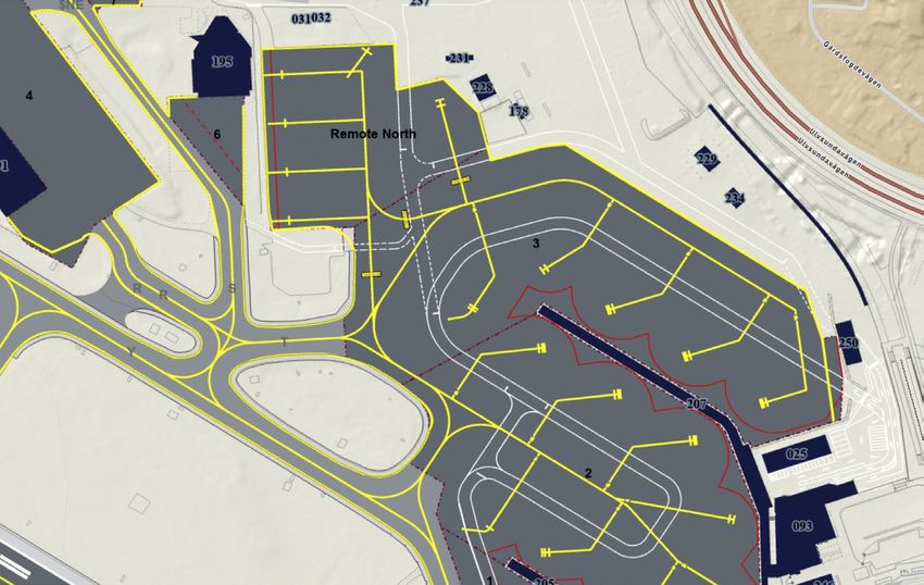
Sekretess: Publik

2. Glossary

     AIP           Aeronautical Information Publication

     A/L           Airside/Landside

     APOC          Airport Planning Operations Centre

     AR            Airport Regulations

     ASDO          Airport Safety Duty Officer

     ATC           Air Traffic Control

     ATS           Air Traffic Service

     BMA           Bromma Stockholm Airport

     EASA          European Aviation Safety Agency

     EUROCONTROL   Pan-European, civil-military organisation

     FPC           Flight Planning Centre

     GP            Glide Path Indicator

     ICAO          International Civil Aviation Organisation

     ILS           Instrument Landing System

     LFV           Air Navigation Service Provider

     NOTAM         A notice to air men (NOTAM) is a notice filed with an aviation authority to alert
                   aircraft pilots of potential hazards and conditions

     PAPI          Precision Approach Path Indicator

     RCR           Runway Condition Report

     RGL           Runway Guard Light

     RWIS          Runway Weather Information System

     RWY           Runway

     SNAP 2.0      A digital SNOWTAM/RCR reporting tool

     SNOWTAM/RCR   A report describing live weather conditions of runways, taxiways and aprons at
                   an aerodrome

     TWR           Tower

     UHF           Ultra High Frequency

     VHF           Very High Frequency

                                                                                                       5
                                 Sekretess: Publik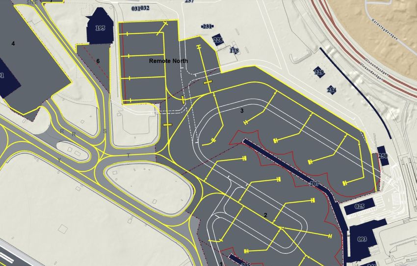
Sekretess: Publik

3. Organization
    3.1 Organizational structure
       Bromma Stockholm Airport belongs to the STO organization within Swedavia International
       Airports. STO (Stockholm) equals the airports ARN(ESSA) and BMA (ESSB)

       Swedavia International Airports:  ARN, BMA, GOT, MMX
       Swedavia Regional Airports: KRN, VBY, RBY, OSD, UME, LLA

    3.2 Snow committee
       Unexpected changes in weather, resources, or limitations
       are discussed, planned and mitigated by the Snow
       removal manager (SRM), APOC and ATS. Together they
       make up the snow committee. Daily follow up is done by
       APOC.

    3.3 Scheduled meetings
       Traffic Tactical Forum       “TTF”           when necessary
       Local Runway Safety Team     “LRST”          every quarter
       Airside Safety Group         “ASSG”          every two months

     3.4 Chain of command

                Snow Removal
                                                              Supervisor
                  Manager

                    Foreman                                   Winter Staff

6
                                         Sekretess: Publik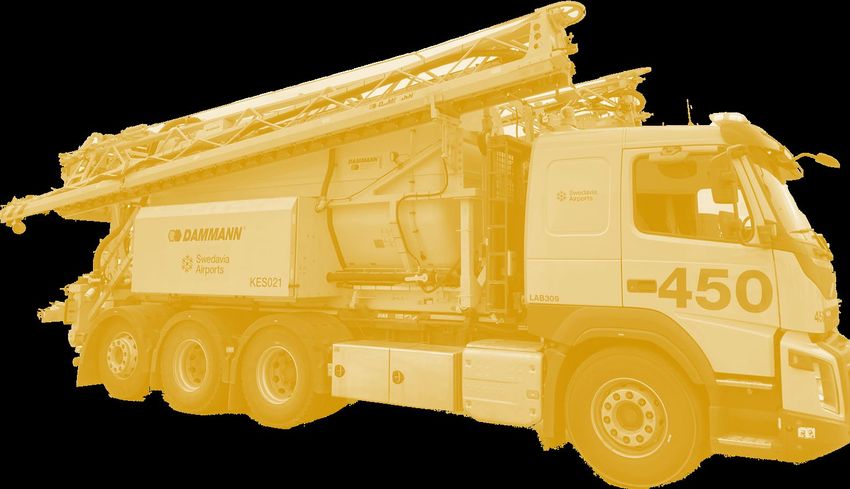
Sekretess: Publik

3.5 Methods of communication
The Snow Removal Manager gathers relevant information from and reports the runway, taxiways
and apron status with a digital tool (SNAP) and sends the report directly from the mobile office.
The Snowtam report goes from reporting tool to Eurocontrol and further on out to the airlines.
The Airport is obligated to send a new Snowtam or RCR report with every significant change in
weather based on assessment of conditions according to RCAM (Runway Condition Assessment
Matrix)

Other means of communication:
- VHF radio - UHF radio – Telephone - E-mail - AI (Airport Information)- SNOWTAM – NOTAM -
Text messages - Intranet (web) - Extranet (web) - IAIP

     ASDO
                                                           FPC

  FOREMAN

METEOROLOGIST

     RWIS

  TWR/ATC

                                                                                     AIRLINES
   INPUT                                 SNAP 2.0
                          SNOW REMOVAL MANAGER
                            RWY CONDITION REPORT
            OUTPUT

    APOC

   AIRPORT

                                                                                                    7
                                       Sekretess: Publik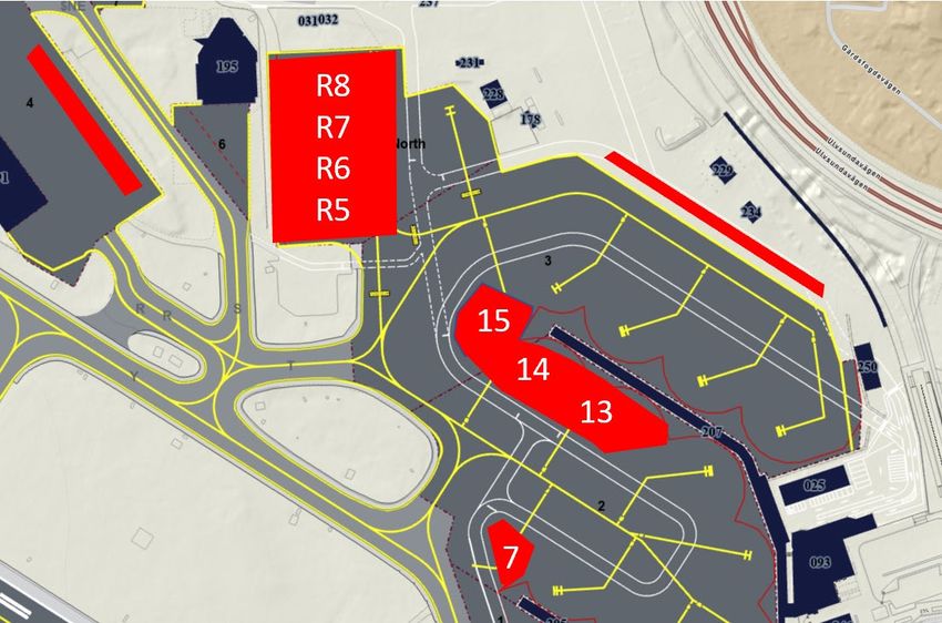
Sekretess: Publik

4. Resources
      4.1 Vehicles

          TOWED JET SWEEPER
                               BIG SNOW BLOWER
                 10 x                  1x
                                                        DE-ICING SPRAYER
                                                             (45 meter)
                                                                 1x        FRICTION TESTER
                                                                                 2x

     SAND & DE-ICING
    SPRAYER (36 meter)                          WHEEL LOADER
                         CARRIED SNOW              4x
       1x                                                          TRACTOR
                           BLOWER
                                                                    1x
                          2x                                                     SMALL
                                                                                CARRIER
                                                                                2x

                                                                 SNOW TRANSPORT
                                                                      (40 m3)
                                                    EXTERNAL TRUCKS
                                                   (FOR SNOW REMOVAL)    1x
                                  PICK-UP TRUCKS &       7x
                                        CARS
                 DE-ICING SWEEPER
                                      4x
                    2x

8
                                        Sekretess: Publik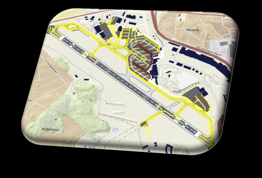
Sekretess: Publik

     4.2 Tools & Chemicals

WEATHER & FLIGHTPLANNING
SYSTEMS                                                                      RUNWAY WEATHER
                                                                           INFORMATION SYSTEM
                     DIGITAL REPORTING TOOLS                                     (RWIS)

                                              GEOFENCED DE-ICING
                                                 TECHNOLOGY

RWY DE-ICING FORMATE
 AVIFORM L50 LIQUID: 200 m³
  AVIFORM S-SOLID: 15 tons                                               AIRSIDE GRIT                      LANDSIDE SALT
                                       DIESEL                           600 tons (< 4,75 mm)                       20 tons
                                    HVO100: 50 m³
                                                     AD-BLUE
                                                         2 m³
                                                                                               LANDSIDE GRIT
                                                                                                50 tons (6-8 mm)

                                  AIRCRAFT DE-ICING FLUID
                              TYPE I: 24 m³           TYPE I I: 24 m³

                                                                   WE ONLY USE 100% FOSSIL FREE FUEL
                                                                                                                             9
                                                    Sekretess: Publik
Sekretess: Publik

10
     Sekretess: Publik
Sekretess: Publik
4. Organisation 4.3 Manpower & resources in use
Standard manpower = 3 shifts x 16 resources.
On site workshop = 3 resources 7pm-16pm. (available on call after standard working
hours)
Image below shows the minimum number of resources/shift needed to comply all
operative surfaces during a specific weather category number.
Category 1 – Plus degrees, no snow (no restrictions)
2x 4x 1x 1x 1x 1x
Category 2 – Frost/Ice, no snow (no restrictions)
2x 4x 2x 1x 2x 2x
Category 3 – Light/medium (8 min clearing – 22 min take off & landing)
3x 8x 2x 1x 2x 1x 2x 1x 1x 1-3x
Category 4 – Intense (8 min clearing – 16 min take off & landing)
3x 8x 2x 1x 2x 1x 1x 4x 1x 2x 1x 5-7x
Category 5 – Extreme (8 min clearing – 8 min take off & landing)
3x 8x 2x 1x 2x 1x 1x 4x 1x 2x 1x 7x
11
Sekretess: PublikSekretess: Publik
12
Sekretess: PublikSekretess: Publik
4.4 Planning of resources and machinery
BMA Airport plans the number of working resources based
on weather categories.
The specific categories are based on weather data
gathered over 10+ years and determines the manpower in
use during that specific category. Category and manpower
equals the necessary amount of resources to ensure snow
clearing of prioritized areas and safe take-off and landing.
The categories are provided by the weather service along
with the weather forecast.
The Snow Removal Manager is responsible to ensure that
the categorized number of resources are at the scene. The
list (see 4.4) is an example of machines in use (type of
machines in use varies during operating hours).
During category 4-5 closed TWY:s may occur due to
clearing of visual aids and snow profiles.
BMA Airport field staff and BMA Vehicle workshop maintains
and ensures that the vehicle fleet is operational.
The snow removal manager is responsible to ensure
adeqate number of resources per category. APOC tracks
status daily.
13
Sekretess: PublikSekretess: Publik
5. Snow Plan: Table of contents
Operations
5.1 Priority of surfaces to be cleared
ESSB winter operations priorities clearing of the
aerodrome areas in the following order:
During snowfall and clearing
1. Areas and aids necessary for take off and landing (landside, threshold, PAPI, ILS, signs)
2. Runway & emergency routes
3. Taxiways serving the runway
4. Aprons* & remote aprons (clear all markings visible, eventual emergency call-offs)
After snowfall and clearing
5. Measures designed to increase airport usability
6. Completion of runway and taxiways (*snow profiles)
7. Aircraft hangar and stand locations
8. Completion of aprons
9. Other relevant emergency routes (approach 12/30)
10. GP and Localizer areas
11. External requests (asap or within 2 hours)
12. Snow transportation from temporary spots to
permanent locations
* Stands 7,13,14,15 and remote
R5-R8 will not be prioritized during 5.2 Clearance limit for aircrafts using the aerodrome
weather category 3-5 Image shows the general distance and height limits (metric
scale) for adjacent snowbanks
(snow profile) used on Bromma Stockholm Airport.
Profiles around visual aids and ILS-equipment may vary
due to equipment specifications.
For example: Glide Path indicator, PAPI, threshold lights
etc.
RWY EDGE LIGHT
PAVED RWY
CODE 3
ICAO-Airport Service Manual part 2 – Doc 9137 AN/898
14
Sekretess: PublikSekretess: Publik
Snow Plan: Table of contents
5.3 Collection and dissemination of RCR
Snow removal manager
Assesses and determines contamination type and depth on RWY acc. to RCAM.
Adds assessed data in digital reporting tool from mobile office.
Imports RWIS-information to digital tool for comparison with assessed data
Sends oral report to ATS
Sends digital report to EUROCONTROL and FPC
Updates RCR/SNOWTAM report with every significant change on any of the obligated surfaces
Runway information system
Provides the snow removal manager with live-, and forecast information:
Contamination: Type, depth, precipitation frequency
Temperature: Freezing point, dew point, ground temp, ambient temp
Forecast: Freezing point, temperatures, precipitation
System setup: 57 sensors across the RWY + weather station south side of RWY
Surface friction tester
The snow removal manager measures friction with a surface friction tester vehicle (SFT) to see the rate
of change in surface status and to plan clearing actions and frequencies with ATS and to follow up
clearing results.
Note: NO friction readings/values will be reported on RCR/SNOWTAM
(but can be reason for up- or downgrading RCR code acc. RCAM)
Experience and training
Surface status is determined by the snow removal manager.
All reported depths of snow are measured with ruler or tool (metric) and compared and supported with
RWIS sensor results.
The snow removal manager have received adequate training within all related fields.
It takes between 1-3 years of experience and training to become a fully trained Snow removal
manager.
15
Sekretess: PublikSekretess: Publik
5. Snow Plan: Table of contents
Operations
5.4 Clearing method of movement area - Standard
Standard method
The one sweep cycle is the standard snow clearing
method on ESSB. This method allows us to clear the
whole runway and taxiways in use during snowfall
and ongoing traffic. Depending on the intensity of the
actual weather and category we clear the runway inSekretess: Publik
5.5 Clearing method of movement area– Fallback
Two Sweep Cycle
The two sweep cycle is a fallback snow clearing
method on ESSB. This method is mainly used in
snow fall if there is a loss of machines or resources.
But can occasionally be used for light actions on the
manoeuvring area whilst using resources on other
prioritized areas during light weather. This method
allows us to clear the runway in two sweeps.
If using this method during snowfall (category 3-5)
limitations will occur in take off and landings due to
blocking of runway and taxiways.
After completed cycle, clearing of other prioritized
areas are initiated and executed.
Areas covered
Runway: 12-30
Taxiways: Y1, Y2
Optional: Y5, YU, YW, T
Total cycle time: 16 minutes
Time on RWY: 15 minutes
Prio 1
Prio 2
Prio 3
Formation on runway
4x Towed Jet Sweepers
1x Big snowblower
1x 45 m wide Sprayer (folded to 24m)
1x Surface friction tester
17
Sekretess: PublikSekretess: Publik
5. Operations
5.6 Clearing method of other airside surfaces
The other airside areas, surfaces and roads are being cleared simultaneously to the movement area. In short
the airfield maintenance unit is divided into two groups, “runway unit” and the “apron unit”. The apron unit clear
and handles all the other airside objects where the runway unit can’t reach or handle.
The main focus during snowfall is to make passable and de-iced tracks for vehicles and pedestrians and to
support these tracks during the snowfall. After snowfall the focus switches to completely remove all areas from
snow.
The apron unit supports the following areas and follows a specific clearing pattern during snowfall:
Note: Snow clearing and de-icing between gate and aircraft is performed by Swedavia Ground Handling
Blue = Vehicles
Yellow = Pedestrians
18
Sekretess: PublikSekretess: Publik
Snow Plan: Table of contents
5.7 Closing the runway
Reasons to close RWY and closing procedure
If obstacle limitations, visual aids and/or ILS is affected by accumulated snow due to heavily sustained
snow fall and any of the red marked areas are inaccessible we have a reason to close the RWY. The
RWY in itself I usually not the issue for snow clearing, it is the visual aids and snow profiles that can’t be
maintained during a heavily sustained snow fall.
The Snow removal manager has the mandate to close the RWY. The snow removal manager means
to forecast the time for closing 2 hours before due.
An eventual closing decision is always consulted with ATC/FPC for a proper moment to close.
During snowfall and clearing
1. Areas and aids necessary for take-off and landing (landside, threshold, PAPI, ILS, signs)
2. Runway & emergency routes
3. Taxiways serving the runway
4. Aprons* & remote aprons (clear all markings visible, eventual emergency call-offs)
After snowfall and clearing
5. Measures designed to increase airport usability
6. Completion of runway and taxiways (*snow profiles, (see 5.3))
7. Aircraft hangar and stand locations
8. Completion of aprons
9. Other relevant emergency routes (approach 12/30)
10. GP and Localizer areas
11. External requests (asap or within 2 hours)
12. Snow transportation from temporary spots to permanent locations
Opening procedure (when closed)
To clear all necessary snow profiles and visual aids to open up the RWY the time for clearing is:
• 3 hours (1,5 hours for each runway direction, we initiate both directions when closed)
• 3 hours (snow profiles)
• Clearing take place in parallel
Total time: 3 hours
Note: GP and Localizer areas are always cleared pro-actively and active objects cannot be assessed for
clearing during opening hours due to blocking of signal.
19
Sekretess: PublikSekretess: Publik
6. Snow Plan: snow
Temporary Table locations
of contents
The Aircraft Stand Parking Unit allocates aircraft according to the snow locations described below. The
marked snow locations are temporary and are expected to be closed during current weather category.
6.1 During weather category 1
No temporary locations expected.
6.2 During weather category 2
Stand 15,
Remote 7, Remote 8
R8
R7
15
20
Sekretess: PublikSekretess: Publik
Snow Plan: Table of contents
6.3 During weather category 3
Stand 13, 14, 15
Remote 7, 8
Apron 3 (adjacent snow wall on outer road)
Apron 4 (snow wall towards apron 6 and 7)
R8
R7
15
14
13
6.4 During weather category 4 and 5
Stand 7, 13, 14, 15
Remote 5, 6, 7, 8
Apron 3 (adjacent snow wall on outer road)
Apron 4 (snow wall towards apron 6 and 7)
21
Sekretess: PublikSekretess: Publik
7. Snow Plan: Table
Permanent snow of contents
locations
Snow is transported from temporary snow locations after snowfall and clearing
7.1 After snowfall and clearing
Permanent snow location on grass area
22
Sekretess: PublikSekretess: Publik
8. Snow Plan: Table of contents
Deicing
8.1 Deicing
Deicing is performed at actual stand. Deicing liquids are recycled through deicing chutes on Aprons 1-3
and by vacuum trucks and is pumped into recycling towers.
Red snow area
Recycled
(contaminated
Deicing liquid
snow) Dumping chute
towers
for vacuum truck
Deicing chutes (pure liquid) Deicing liquid
filling station
23
Sekretess: PublikSekretess: Publik
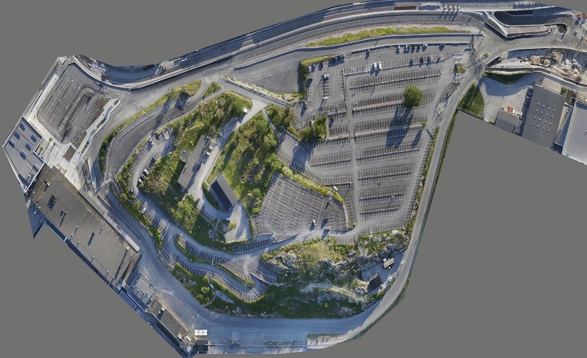
Appendix A: Landside operations
Airfield maintenance prioritize Landside Terminal area according to the following order
DURING Snowfall:
Small carrier (Belos TransPro) Wheel loader (Volvo L60)
Orange Blue and White
1. Walkways from train to arrivals 1. Main road
2. Narrow strip taxi zone 2. Taxi pick-up zone
3. Arrivals Square (by hand) 3. Drop-off/pick-up zone
4. Bus connection 4. Bus zone
5. HCP slot terminal 5. Taxi-bus strip on hill
6. Stairs up to parking lot (by hand) 6. TWR/B20
7. Walkways along terminal 7. Parking lot terminal
8. Unloading zone terminal 8. Parking lot upper
9. Stairs up to upper parking lot Repeat…
10. Goods reception
11. Walkways towards Bromma Blocks The main focus during snowfall is to make passable and de-
12. Walkway and stairs B20 (by hand) iced tracks for vehicles and pedestrians and to support these
13. Walkway from P1 to Car rental tracks during the snowfall. After snowfall the focus switches
Repeat… to completely remove all areas from snow.
- Tracks are de-iced with landside grit and salt (sodium formate 100 m before airside passage/gate)
- No salt, sodium formate or grit on walkways in front of departure terminal unless absolutely necessary.
24
Sekretess: PublikSekretess: Publik
Bromma Stockholm Airport
2023-2024
25
Sekretess: PublikSekretess: Publik Sekretess: Publik
You can also read