BASELINE MONITORING SURVEY FOR WEEDS & FERAL ANIMALS AT THE SOUTHERN HIGHLANDS REGIONAL SHOOTING COMPLEX (SHRSC) WATTLE RIDGE ROAD, HILLTOP NSW
←
→
Page content transcription
If your browser does not render page correctly, please read the page content below
ACS E
          ACS Environmental Pty Ltd

BASELINE MONITORING SURVEY FOR WEEDS
                          & FERAL ANIMALS
 AT THE SOUTHERN HIGHLANDS REGIONAL
                SHOOTING COMPLEX (SHRSC)
                      WATTLE RIDGE ROAD,
                              HILLTOP NSW

Prepared for:

ErSed Environmental Pty Ltd

PO Box 1124, Leichhardt NSW 2040

APRIL 2013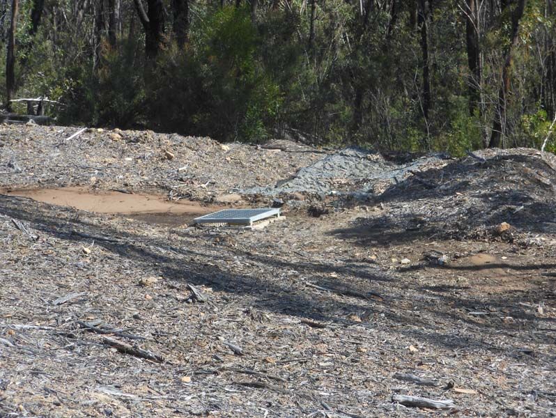
ACS Environmental Pty Ltd
            Flora and Fauna Surveys & Ecological and Biodiversity Impact Assessment Services
                           Australian Business Number (ABN) 24 154 491 120
                             7 Townsend Avenue, Frenchs Forest NSW. 2086
                                 3/28 Tullimbar Rd, Cronulla NSW. 2230
                                                 .
                       Tel: 9527 5262, 9453 9397; Mob: 0403 081902, 0412 217896. Fax: 9527 7454

                                          Email: acs@actinotus.com
                                          Web: www@actinotus.com

Directors and Senior Ecologists

                                                                                α
        Anthony Smith‐White BSc. (Syd), CertHEd., MSc., PhD. (UNSW)

                                            α
        Peter Stricker BSc. (Hons) (Syd)

        α
                  Member Ecological Consultants Association NSW Inc

   The principals of ‘ACS Environmental P/L’ have collectively worked in the area of biodiversity
   impact and bushfire hazard assessment services for a period of greater than 20 years. They
   also have over 30 years of experience in scientific research (ecological, genetic) and teaching in
   biological science.

   The principals of 'ACS Environmental P/L' have completed the NSW Consulting Planners
   Bushfire Training Course organised by the Planning Institute of Australia NSW Division for
   planning consultants and allied professionals relating to the implementation of 'Planning for
   Bushfire Protection', in June 2003.

                                                                                                        i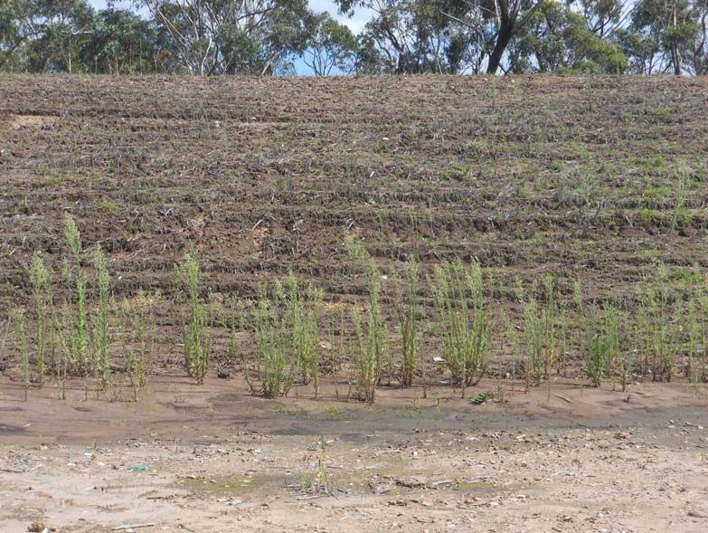
CONTENTS                                                                             Page

1       OVERVIEW                                                                         1

2       PEST SPECIES INCLUDING WEEDS AND FERAL ANIMALS                                   2

3       ECOLOGICAL MANAGEMENT – OPERATIONAL AND
        ENVIRONMENTAL MANAGEMENT PLAN (OEMP)                                             2

4       CURRENT BASELINE SURVEY                                                          4

5       REFERENCES                                                                       6

FIGURES
Figure 1 – Aerial view of the subject lands administered by S & R (SHRSC) including SP1 1
Figure 2 – Recordings of feral pest fauna species                                       26

TABLES
Table 1 – Locations of discrete patches or areas of weed species in relation to the 800m
          Shooting Range                                                                  7
Table 2 – Locations of discrete patches or areas of weed species in relation to the 500m
          and 50m Shooting Ranges                                                        14
Table 3 – Locations of feral fauna pest species in relation to the 800m Shooting Range 24

Table 4 – Locations of feral fauna pest species in relation to the 500m and 50m Shooting
          Ranges                                                                        25

PHOTOGRAPHS – 800m RANGE
Photo 001 – Small patch at 500m from target. Variable species.                          10
Photo 002 – Small patch at 410 ‐ 420m from target. Kikuyu.                              10
Photo 003 – Lineal patch of Kikuyu at 250m from target.                                 11
Photo 004 – Wash‐out zone at 210m from target. Variable species.                        11
Photo 008 – Mulched corridor along western boundary of range.                           12
Photo 009 – Typical exotic grassed area occurring at 300M from target
            on the 800m Shooting Range.                                                 12
Photo 010 – Typical grassed vegetation along Range.                                     13
Photo 015 – Weeds occurring together with native seedlings within drainage
            gutters along access road.                                                  13

PHOTOGRAPHS – 50m PISTOL RANGE
Photo 16 – Lineal row of Tall Fleabane at base of berm.                                 17
Photo 19 – End berm wall showing Fleabane at base and weed
           occurrence on berm wall.                                                     17
Photo 18 – Southern berm wall and base, less weeds.                                     18
Photo 20 – Spray‐grassed flat area along northern boundary of range                     18
Photo 23 – Drainage ditch to sediment pond below Pistol Range                           19

                                                                                              ii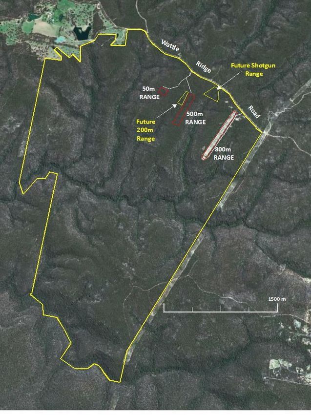
CONTENTS                                                                      Page

Photo 25 – Weeds in drainage ditch alongside sediment mound from 500m Range     19

PHOTOGRAPHS – 500m RANGE
Photo 28 – Drainage ditch along western edge of Range, weed‐free.               20
Photo 31 – Sediment drain at north‐west corner of 500m Range, weed free.        20
Photo 33 – Weeds at base of target berm on 500m Range                           21
Photo 35 – Drainage ditch eastern side of 500m Range, weed free.                21
Photo 37 – Weeds at base of intermediary berm on 500m Range.                    22
Photo 38 – Weeds at base of firing berm on 500m Range.                          22
Photo 42 – View of weeds from firing berm to target berm.                       23
Photo 46 – View of weeds occurring over car park site.                          23

                                                                                     iii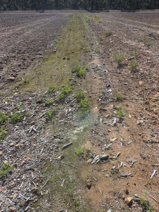
BASELINE MONITORING SURVEY FOR WEEDS & FERAL ANIMALS
AT THE SOUTHERN HIGHLANDS REGIONAL SHOOTING COMPLEX
(SHRSC,) WATTLE RIDGE ROAD, HILLTOP NSW

 1       OVERVIEW

 An existing rifle range site at Hilltop, operational since 1987 and modified in 2008,
 has been approved by the NSW Government (2004) to be developed as a regional
 shooting complex, becoming operational in 2010. Currently vegetation for the
 existing 800m range, the 500m range and the pistol range has been cleared and the
 ranges are established or being developed for operation (Figure 1). The shooting
 range facility is qualified as the Southern Highlands Regional Shooting Complex
 (SHRSC).

 The complex occurs on land vested in and managed by the State Sporting Venues
 Authority (SSVA or S & R), which incorporates an Environmental Conservation Zone
 (E2) of about 900ha and a Special Activity Zone (SP1) of about 136ha, the latter
 containing the shooting facilities that comprise an area of about 25ha (Figure 1).

 Figure 1 – Aerial view of the subject lands administered by S & R (SHRSC) including SP1

                                                                                         1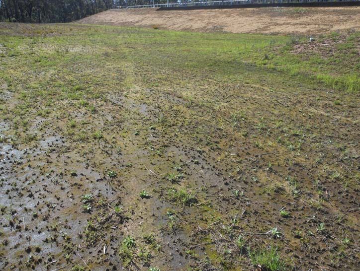
2       PEST SPECIES INCLUDING WEEDS AND FERAL ANIMALS

The agency Sport and Recreation (S & R) has committed to the implementation of:

           ‐ Weed management activities by periodic monitoring events and
             removal and control by qualified bush regenerator personnel using
             established, best‐practice bush regeneration techniques, and
           ‐ Mitigation Measures of the Supplementary Ecological Assessment
             including:
           - Monitoring of European Rabbit and European Red Fox activity within
             cleared firing ranges and implementation of control management
             plans.

3       ECOLOGICAL MANAGEMENT – OPERATIONAL AND
        ENVIRONMENTAL MANAGEMENT PLAN (OEMP)

The OEMP (GHD 2011 Draft Report) provides the framework for day‐to‐day
operation of the SHRSC facility and the management of range and off‐range
ecological impacts. It reflects the commitments made by S&R in the Environmental
Assessment Report (GHD 2007) and Preferred Project Report (July 2008) relating to
operation of the project and relevant development conditions.

The OEMP reflects the values detailed in the Conservation Agreement under the
National Parks and Wildlife Act 1974 between the Minister for the Environment and
the Minister for S&R signed on 12 October 2010 in respect to Lot 100, DP 1088254. It
is also consistent with the management regime incorporated in the various
conditions of approval.

The OEMP details specific mitigation measures to minimise potential for off‐site
impacts on native vegetation (Appendix E of the Environmental Management
Plan).

Operation of the venue as a regional shooting complex has the potential to
introduce and facilitate the spread and establishment of weeds within the site and
into adjacent vegetation.

Weed Management Strategy

The following measures will be implemented to mitigate potential impacts of weeds
on native vegetation and habitats and are consistent with item 1(a) of the
Conservation Agreement:
– Implementation of a weed management strategy:
– removal and control of noxious weeds using appropriate methods and timing;
– reduction of edge effects and invasion of exotic species into adjacent vegetation;
– weed species to be monitored on an annual basis by professional bush
    regenerator;

                                                                                    2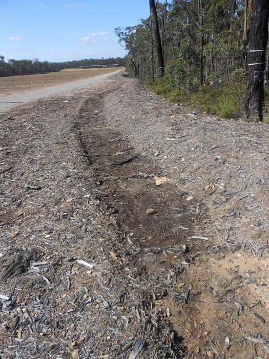
–   all weed management activities to be undertaken by qualified bush regenerators
    using established bush regeneration techniques;
–   every reasonable precaution will be taken to avoid introducing or encouraging
    the proliferation of noxious weeds or other undesirable and non‐indigenous
    plants; and
–   any new infestations of weeds will be eradicated or controlled as soon as
    practical consistent with NSW Government weed eradication procedures and
    Noxious Weeds Act as applicable and as outlined in the weed management
    strategy.

Threats and management measures associated with weed invasion during the
operational phase

Threats include weed establishment on disturbed soils within the construction area
and adjoining vegetation. Associated management measures include:
– Completion of annual weed surveys by bush regenerator personnel, to compare
  the pre (zero or negligible weeds) and post construction environments, and
– Weed control as required according to the weed management strategy to be
undertaken by professional bush regenerator personnel.

The spread of weeds throughout OEMP area can be monitored by:

– Completion of annual weed surveys by bush regenerator, to compare the pre (zero
or negligible weeds) and post construction environment.
– Photos will be taken at the established photo points to compare with pre‐
construction conditions as per the Conservation Agreement.

Weed monitoring and control

Specifically the following measures will be undertaken to survey and monitor the
occurrence of weed incursions:

_ existing weeds to be surveyed and mapped by the contractor’s ecologists within
   the vicinity of construction sites and adjoining areas of native vegetation during
   pre‐clearing surveys to identify current baseline weed levels, inform future
   management and to enable comparison of pre‐ and post‐construction
   environment;
_ vegetation photo‐points to be established in vegetation adjoining the development
   areas as per the Conservation Agreement. Photos will be taken at the established
   photo‐points to compare with pre‐construction conditions;
_ annual weed surveys to be completed by a professional bush regenerator to
   compare the pre (zero or negligible weeds) and post construction environments;
   and
_ any weed outbreaks identified in yearly surveys of the SP1 Zone to be treated by a
   professional bush regenerator using appropriate control techniques.

                                                                                     3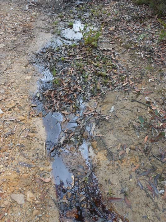
Weed Presence

The SP1 zone of the site has been declared as essentially ‘weed free’ (though refer to
current weed status report of areas within SP1, as at March 2013). Any further
future development of the site will require regular monitoring to ensure that any
small, newly‐established weed populations can be easily removed by hand, or similar
small‐scale methods. Weekly site inspections of the construction area will be
included as a contract requirement for construction personnel to report any weed
occurrence on the construction area or in adjoining vegetation for early removal and
management.

The presence of weeds in the SP1 area is to be monitored annually by a qualified
bush regenerator personnel n accordance with the Conservation Agreement.
Baseline weed mapping undertaken in the development area and immediate
surrounds during the pre‐construction phase and photos at established photo points
following construction activities will be used to determine changes in weed levels
and to identify required management activities.

Photos are to be taken annually at established photo‐points in the plan area to
monitor changes in weed levels and to form the basis for decisions on ongoing
management activities.

Weed management in the plan area are consistent with programs to be applied to
the surrounding Parks and Wildlife Group (PWG) estate and may form a component
of the agreed annual works program undertaken by an environmental management
contractor engaged by S&R. A report on the annual works and the targets met by the
program will be submitted to S&R at the end of each financial year.

4         CURRENT BASELINE SURVEY

Methodology

An initial baseline survey of weeds and evidence of feral animals at the 800m, 500m
and 50m Pistol Range sites, as well as access roads, tracks and constructed drainage
ditches, was undertaken on 6th March 2013.

Each area was surveyed on foot (DEC 2004), discrete weed occurrence locations
were identified and recorded in quadrats or along linear transects and weed species
ranked frequency of occurrence and evidence of feral animal distributions recorded.

Photo points were established at significant occurrences of weed incursions.

Results

Results are tabulated and presented in Tables 1 ‐ 4.

                                                                                       4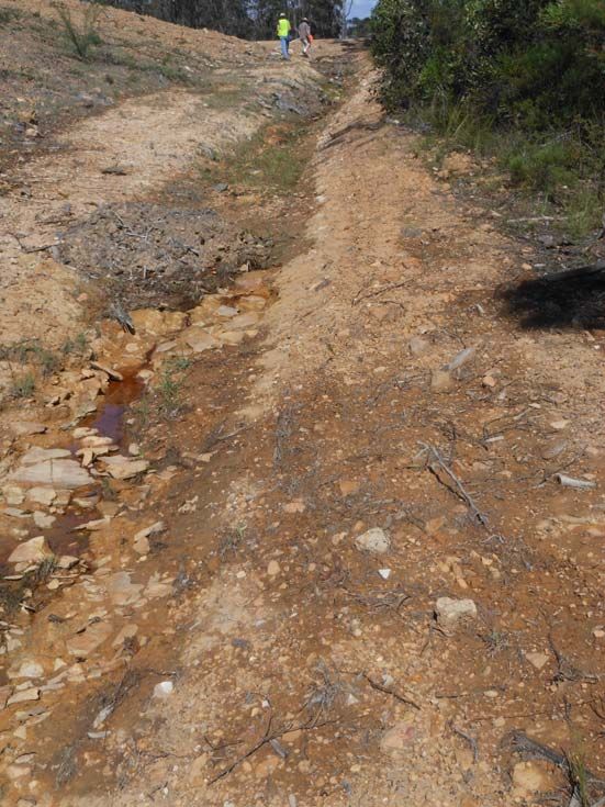
Conclusions:
1 800m Shooting Range
Weed species:
The 800M Shooting Range became operational in 1988.
Weeds occur in small patches particularly along the eastern, mulched border
of the shooting range and often in association with downslope wash out
zones onto the adjacent access road (Table 1).
The mulch material bounding the eastern and western boundaries of the
800m Shooting Range originates from mulching of natural bushland on the
recently cleared areas for the 500m Shooting Range and the 50m shooting
range (Pistol Range) (Figure 1). These areas were cleared about 2 years
previously and contained no weed source material.
All weed species currently occurring on the mulched borders derive from the
exotic grassland assemblage that constitutes the vegetation of the shooting
range (Table 1). The most common weed species include Flaxleaf Fleabane,
Cats Ear, Kikuyu, Common Couch and Slender Pigeon Grass.
All scattered occurrences of weed incursion along the eastern mulched
border of the range and along the access road along its eastern boundary can
be removed by hand‐pulling or spraying as the occurrences are not extensive
and readily controlled. Regular monitoring and weed control is
recommended to ensure weed occurrence is contained.
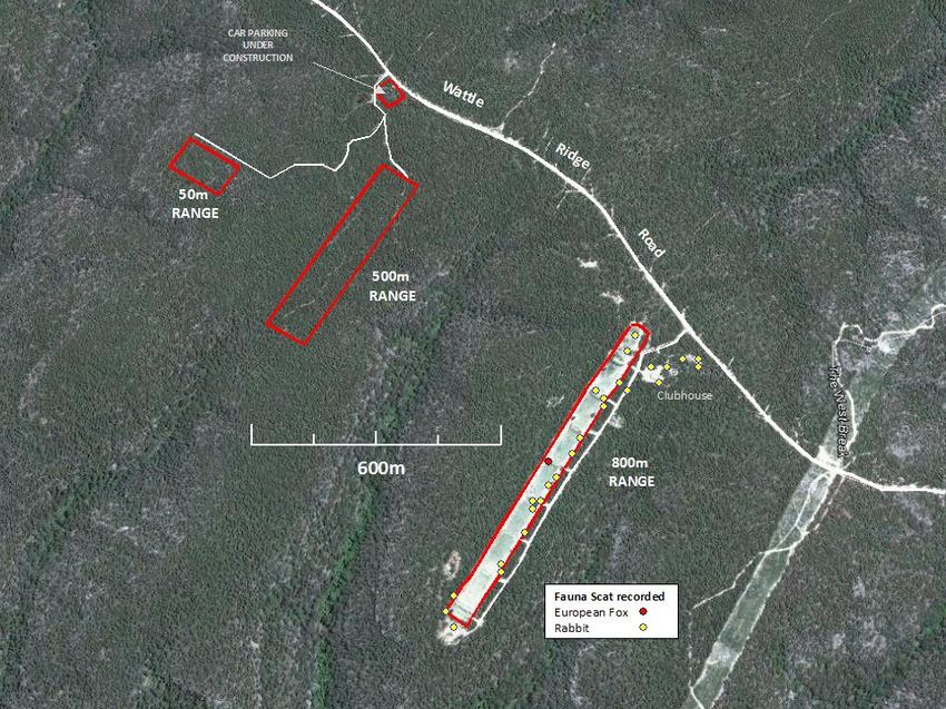
Feral Fauna Pest Species:
Rabbit scat was recorded in several locations within the mulch along the
south‐eastern side of the 800m shooting range and in one location on the
north‐western corner. Scat was also recorded on top of the 700m and 500m
berms and within the grassy areas between the 800m and 700m berms and
between the 200m and 300m berms. A map marking distribution of scats is
shown in Figure 2 (page 27).
No rabbit warrens were recorded within the study area.
Fox scat was recorded close to the 400m berm on the north‐western side of
the range (Figure 2, Table 3).
No fox lairs were recorded within the study area.
5
2      500m Shooting Range & Pistol Range (50m Range)

Weed species:

       Weeds occur on ‘spray‐grass’ treated berms (target and side walls and
       intermediary hill rises along the range), in moist depression sinks along the
       frontal base of berms and in drainage ditches draining to sediment ponds
       and in drainage gutters along access roads (Table 2).

       Natural bushland was recently cleared in areas for the 500m Shooting Range
       and the 50m shooting range (Pistol Range) (Figure 1). These areas were
       cleared about 2 years previously and contained no weed source material.

       All weed species occurring on the 500m shooting range and Pistol Range
       derive from spray‐grass treatment of cleared areas and from weed sources
       inadvertently brought in externally. The most common weed species include
       Tall Fleabane, Red Clover, White Clover, Purple Cudweed, Purple Top and
       Barnyard Grass (Table 2).

       All occurrences of weed incursion at the 500m Shooting Range and Pistol
       Range could eventually be removed by hand‐pulling or spraying and can be
       readily controlled. Regular monitoring and weed control is recommended to
       ensure weed occurrence is contained.

Feral Fauna Pest Species:

       No feral pest species were recorded in this section of the study area (Table 4).

5       REFERENCES

DEC (2004) threatened Biodiversity and Assessment: Guidelines for Developments
            and Activities

GHD (2007) Southern Highlands Regional Shooting Complex – Ecological Assessment

GHD (2011) Southern Highlands Regional Shooting Complex ‐ Operational and
           Environmental Management Plan

                                                                                       6
Table 1 – Locations of discrete patches or areas of weed species in relation to the 800m Shooting Range
SITE DESCRIPTION 1 2 3 4 5 6 7 WEST SHOOTING ACCESS
EASTERN EASTERN EASTERN EASTERN EASTERN EASTERN EASTERN EDGES RANGE ROAD TO
EDGE EDGE EDGE EDGE EDGE EDGE END BERM EAST
TARGETS
COMMENTS Small Small Small Lineal Wash‐out On grassy Along On grassy In
patch patches patch patch zone berm mulched range drainage
edge channels
DISTANCE FROM 500 410 ‐ 420 390 250 210 100 0 180, 210, 300
TARGET (M) 260
COORDINATES 34.31773 34.31836 34.31989
(DECIMAL DEGREES) 150.45615 150.45565 150.45443
AREA (M) 1 X 1M 1 X 1M 1 x 1M 7 X 1M 2 X 2M 800 X 40M
PHOTO TAKEN 001 002 003 004 005, 006, 008 009, 010, 012, 013,
007 011 014, 015
SPECIES COMMON NAME
SCIENTIFIC NAME
MAGNOLIOPSIDA:
MAGNOLIDAE
Asteraceae
Cirsium vulgare Common Thistle u u
Conyza bonariensis Flaxleaf Fleabane o o o o
Hypochaeris radicata Cats Ears o c u o o o u c o
Senecio Fireweed u u
madagascariensis
7SPECIES COMMON NAME 1 2 3 4 5 6 7 WEST SHOOTING ACCESS
SCIENTIFIC NAME EASTERN EASTERN EASTERN EASTERN EASTERN EASTERN EASTERN EDGES RANGE ROAD TO
EDGE EDGE EDGE EDGE EDGE EDGE END BERM EAST
TARGETS
Fabaceae: Faboideae
Trifolium repens White Clover o
Gentianaceae
Centaurium o o u
tenuiflorum
Oxalidaceae
Oxalis corniculata Oxalis o o
Verbenaceae
Verbena litoralis Purple Top o
MAGNOLOPSIDA:
LILIDAE
Cyperaceae
Cyperus eragrostis Umbrella Sedge u
8SPECIES COMMON NAME 1 2 3 4 5 6 7 WEST SHOOTING ACCESS
SCIENTIFIC NAME EASTERN EASTERN EASTERN EASTERN EASTERN EASTERN EASTERN EDGES RANGE ROAD TO
EDGE EDGE EDGE EDGE EDGE EDGE END BERM EAST
TARGETS
Poaceae
Axonopus affinis Narrow‐leaved o o
Carpet Grass
Cynodon dactylon Common Couch o o o c c
Eragrostis mexicana Mexican Lovegrass o
Paspalum dilatatum Paspalum o
Pennisetum Kikuyu o c o c c c
clandestinum
Setaria gracilis Slender Pigeon o o o c
Grass
9PHOTOGRAPHS ‐ 800M RANGE
Photo 001 – Small patch at 500m from target. Variable species. Photo 002 – Small patch at 410 ‐ 420m from target. Kikuyu.
10Photo 003 – Lineal patch of Kikuyu at 250m from target. Photo 004 – Wash‐out zone at 210m from target. Variable species.
11Photo 008 – Mulched corridor along western boundary of range. Photo 009 – Typical exotic grassed area occurring at 300m from
target on 800m Shooting Range.
12Photo 010 – Typical grassed vegetation along Range. Photo 015 – Weeds occurring together with native seedlings within
drainage gutters along access road.
13Table 2 – Locations of discrete patches or areas of weed species in relation to the 500m Shooting Range
SITE DESCRIPTION PISTOL RANGE ROADWAY 500M RANGE CARPARK
WITHIN SITE 1 2 3 4 5 6 7 8 9 10
DESCRIPTION STH END STH END EAST SIDE EAST SIDE SPRAY DRAINAGE DRAINAGE END BERM BELOW CARPARK
BERM BASE BERM BERM BERM GRASSED DITCH DITCHES BASE & MAIN AREA
WALL BASE WALL FLAT AREA (RANGE) (ROAD) OTHER FIRING
BERMS BERM
COMMENTS Tall weeds Less weeds Less weeds Low freq 50% bare Drains to Mostly Moist area Moist
weeds ground west weed free areas
APPROX. AREA (M) 625 M2 840 M2 200 M2 500 M2 1250 M2 600 M2 1800 M2 8000 M2
PHOTO TAKEN 16, 19 17, 19 18 20 21, 22 23, 24 25 33, 34, 35, 38, 39, 40, 44, 45, 46
(around 37 41, 42, 43
range: 26,
27, 28, 29,
31, 32,
36 (E)
SPECIES COMMON NAME
SCIENTIFIC NAME
MAGNOLIOPSIDA:
MAGNOLIDAE
Asteraceae
Cirsium vulgare Common Thistle u
Conyza sumatrensis Tall Fleabane c c c c o c c
Gamochaeta Purple Cudweed o o c c
purpurea
Hypochaeris radicata Cats Ears o
14SITE DESCRIPTION PISTOL RANGE ROADWAY 500M RANGE CARPARK
WITHIN SITE 1 2 3 4 5 6 7 8 9 10
DESCRIPTION STH END STH END EAST SIDE EAST SIDE SPRAY DRAINAGE DRAINAGE END BERM BELOW CARPARK
BERM BERM BERM BERM GRASSED DITCH DITCHES BASE & MAIN AREA
BASE WALL BASE WALL FLAT AREA (RANGE) (ROAD) OTHER FIRING
BERMS BERM
SPECIES COMMON NAME
SCIENTIFIC NAME
Asteraceae (cont)
Senecio Fireweed o o o u o o
madagascariensis
Tagetes minuta Stinking Roger u
Fabaceae: Faboideae
Trifolium pratense Red Clover o u o
Trifolium repens White Clover o o o o u c c
Malvaceae
Modiola caroliniana Red‐flowering u o
Mallow
Oxalidaceae
Oxalis corniculata Oxalis o
Polygonaceae
Polygonum Wireweed o o o
arenastrum
15SITE DESCRIPTION PISTOL RANGE ROADWAY 500M RANGE CARPARK
WITHIN SITE 1 2 3 4 5 6 7 8 9 10
DESCRIPTION STH END STH END EAST SIDE EAST SIDE SPRAY DRAINAGE DRAINAGE END BERM BELOW CARPARK
BERM BERM BERM BERM GRASSED DITCH DITCHES BASE & MAIN AREA
BASE WALL BASE WALL FLAT AREA (RANGE) (ROAD) OTHER FIRING
BERMS BERM
SPECIES COMMON NAME
SCIENTIFIC NAME
Verbenaceae
Verbena bonariensis Purple Top o o o o o
Verbena litoralis Purple Top u
MAGNOLOPSIDA:
LILIDAE
Cyperaceae
Cyperus eragrostis Umbrella Sedge u u
Poaceae
Axonopus fissifolius Narrow‐leaved o o o
Carpet Grass
Cynodon dactylon Couch o o
Echinochloa crus‐galli Barnyard Grass o o c c c c o
Eleusine indica Crowsfoot Grass u
Setaria gracilis Slender Pigeon o o
Grass
16PHOTOGRAPHS – 50m PISTOL RANGE
Photo 16 – Lineal row of Tall Fleabane at base of berm Photo 19 – End berm wall showing Fleabane at base and weed occurrence on berm wall
17Photo 18 – Southern berm wall and base, less weeds Photo 20 – Spray‐grassed flat area along northern boundary of range
18Photo 23 – Drainage ditch to sediment pond below Pistol Range Photo 25 – Weeds in drainage ditch alongside sediment mound from
500m Range
19PHOTOGRAPHS – 500m RANGE
Photo 28 – Drainage ditch along western edge of Photo 31 – Sediment drain at north‐west corner of 500m Range, weed free
Range, weed‐free.
20Photo 33 – Weeds at base of target berm on 500m Range. Photo 35 – Drainage ditch eastern side of 500m Range, weed free.
21Photo 37 – Weeds at base of intermediary berm on 500m Range. Photo 38 – Weeds at base of firing berm on 500m Range.
22Photo 42 – View of weeds from firing berm to target berm. Photo 46 – View of weeds occurring over car park site.
23Table 3 – Locations of feral fauna pest species in relation to the 800m Shooting Range
WITHIN SITE COMMENTS 1 2 3 4 5 6 7 SHOOTING ACCESS
DESCRIPTION EASTERN EASTERN EASTERN EASTERN EASTERN EASTERN EASTERN RANGE ROAD TO
EDGE EDGE EDGE EDGE EDGE EDGE END BERM EAST
TARGETS
Rabbit scat Recorded close to the Recorded at
clubhouse and 700m and
surrounds 500m berms
European Fox scat
No recordings
WITHIN SITE 1 2 3 4 5 6
DESCRIPTION WESTERN WESTERN WESTERN WESTERN WESTERN WESTERN
EDGE EDGE EDGE EDGE EDGE EDGE
Rabbit scat Recorded in grassy
areas between 200m
and 100m
European Fox scat One scat found on
mulched area
24Table 4 – Locations of feral fauna pest species in relation to the 500m and 50m Pistol Range
SITE DESCRIPTION COMMENTS PISTOL RANGE ROADWAY 500m RANGE CARPARK
WITHIN SITE 1 2 3 4 5 6 7 8 9 10
DESCRIPTION STH END STH END EAST SIDE EAST SIDE SPRAY DRAINAGE DRAINAGE END BERM BELOW CARPARK
BERM BASE BERM BERM BERM GRASSED DITCH DITCHES BASE & MAIN AREA
WALL BASE WALL FLAT AREA (RANGE) (ROAD) OTHER FIRING
BERMS BERM
Rabbit scat No recordings
European Fox scat No recordings
25Figure 2 – Recordings of feral pest fauna species.
265 REFERENCED DOCUMENTS
Conservation Agreement dated 12 October 2010 pursuant to Section 69B Part 4 Division 12
of the National Parks and Wildlife Act 1974 between the Minister for the
Environment and Minister for S&R in respect to Lot 100, DP 1088254.
Ecological Management Plan 7 October 2010
GHD (2008) Southern Highlands Regional Shooting Complex: Supplementary Ecological
Assessment. Report prepared for NSW Sport and Recreation. Sydney, NSW.
GHD (2011 Draft) Southern Highlands Regional Shooting Complex Operational and
Environmental Management Plan.
Preferred Project Report July 2008
27You can also read