Jennifer Gilbert, CFM State Floodplain Management Program Coordinator Samara Ebinger, CFM Assistant Coordinator - NH.gov
←
→
Page content transcription
If your browser does not render page correctly, please read the page content below
Jennifer Gilbert, CFM
State Floodplain Management
Program Coordinator
Samara Ebinger, CFM
Assistant Coordinator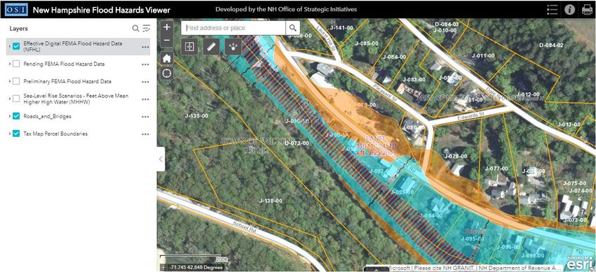
Agenda

• National Flood Insurance Program (NFIP) -
  Overview
• Flood Insurance
• Floodplain Mapping
• Community Floodplain Regulations –
  Minimum NFIP Requirements
• Wrap Up/Resources
                                        2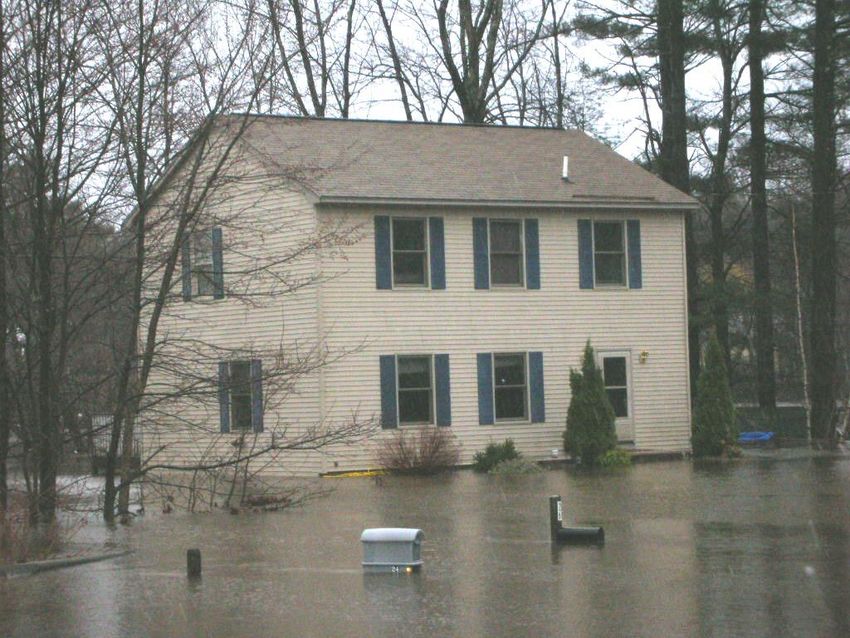
What is the National Flood
           Insurance Program?

• Created by Congress
  in 1968
                               Know Your Risk
                                 Floodplain
• Voluntary                       Mapping
  partnership between
  FEMA and
  participating         Reduce Your      Insure Your
  communities               Risk             Risk
                         Floodplain         Flood
                        Regulations       Insurance

                                                4
NFIP Participation

• Community agrees to adopt local floodplain
  regulations and enforce them through a local
  permitting process.
• NFIP flood insurance is available for purchase,
  for all property owners and renters in the
  community.

                                           5
NFIP Participation in
  New Hampshire

 • 219 communities
   (93%) participate

 • 17 communities (7%)
   do not participate

                         6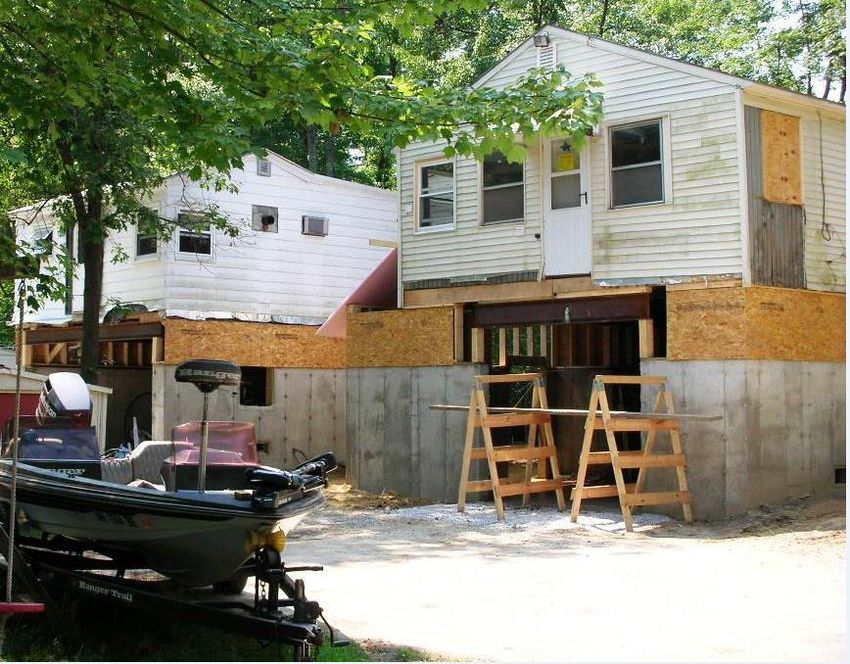
Federal, State, and Local Roles in the
                 NFIP
FEMA
 – Makes available flood insurance
   for purchase in participating
   communities
 – Risk identification (mapping)
 – National program oversight
 – Establish development/building
   standards and guidance
 – Monitor compliance

                                     7
Federal, State, and Local Roles in the
                 NFIP

State Role
  – Technical assistance to all
    stakeholders
  – Education and outreach
  – Model floodplain
    regulations
  – Assist communities in
    evaluating compliance of
    floodplain activities and
    post-disaster activities

                                  8
Local (Community)
            Role and Responsibilities

• Understand your community’s regulations and FEMA maps
• Ensure that local permits are applied for, for all development in
  Special Flood Hazard Areas within the community
• Review and process permit applications for floodplain
  development
• Ensure floodplain development (including community’s) is built
  according to approved permits and floodplain regulations
• Take enforcement actions; correct violations

                                                         9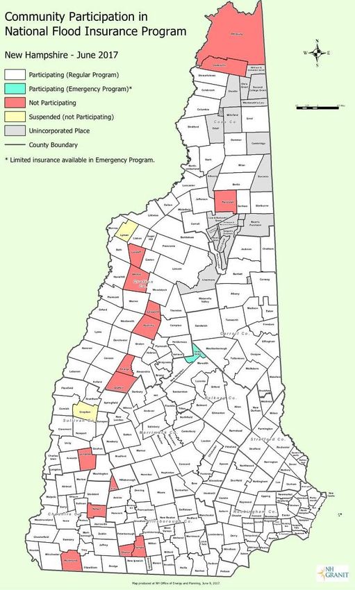
Lender Floodplain Requirements

• Flood Disaster Protection Act of 1973
• Lending institutions cannot make, increase,
  extend, or renew a loan for a building located in
  the floodplain (Special Flood Hazard Area)
  without flood insurance
• It is the responsibility of the lender to:
   – determine if the property is in the Special Flood Hazard
     Area,
   – document the determination, and
   – ensure the insurance is maintained through the life of
     the loan.
                                                      11
Floodplain Regulations and
Insurance
• Community floodplain regulations apply for
development in the Special Flood Hazard Area
(SFHA) regardless of whether or not a
property has flood insurance.
• If a structure built in the SFHA is not built in
compliance with community floodplain
regulations, the cost of flood insurance will be
more expensive for that property.
12Flood Insurance:
Always a Good Idea to Have!
• Anywhere it can rain, it can flood.
• Any resident or business owner is
eligible to purchase NFIP flood
insurance in a participating
community.
• Homeowners and renters insurance
does not typically cover flood damage.
• Flood insurance can pay regardless of
whether or not there is a Presidential
Disaster Declaration for Individual
Assistance.
13Flood Insurance Rate Maps (FIRM) and the
Flood Insurance Study (FIS) Report
15What are FIRMs and FIS Reports
Used For?
Produced by FEMA and used by:
• Municipal officials to determine a) which areas of their
community are subject to its floodplain development
regulations and b) the building requirements that apply
for development activity in floodplain areas.
• Lenders to determine which properties require flood
insurance as a condition of a mortgage or other loan.
• Insurance agents to determine flood insurance rates for
properties.
• The general public to understand flood risk in their
area. 16The 1% Annual Chance Flood
• National standard used by the NFIP for regulating
new development and flood insurance requirements
• Sometimes called the base flood or the “100-year”
flood
• The area of the 1% annual chance flood on the FIRM
is called the Special Flood Hazard Area (SFHA)
17Flood Zones on the Maps
Special Flood Hazard Areas (SFHAs) contain all zones that start with
the letter A or V.
Areas outside of the SFHA are designated as ‘Zone X’.
18Base Flood Elevations (BFEs)
The height above
sea level to
which flood
water would be
expected to rise
in a 1% annual
chance flood
event.
19The Regulatory Floodway
20Specific Special Flood Hazard Area
(SFHA) Zones
• Zone AE: Include Base Flood Elevations (BFEs), may
include a floodway along rivers and streams.
• Zone A: Does not include BFEs.
• Zone AO: Areas of shallow flooding with a depth
between 1 and 3 feet.
• Zone VE: Coastal High Hazard Area – areas affected
by waves higher than 3 feet; include BFEs.
21Limit of Moderate Wave Action
(LiMWA)
• Boundary of the “Coastal A
Zone”
• The inland limit of the area
expected to receive 1.5 foot or
higher breaking waves during
a 1% annual chance flood.
• Special building requirements
apply per current State
Building Code (2015 IRC and
IBC).
22Rockingham County Communities with a
LiMWA Shown on New Flood Maps
• Hampton
• Hampton Falls Learn more about
• Little Boar’s Head Village District the LiMWA at our
12/15 webinar
• New Castle about Coastal A
• North Hampton Zones and V Zones!
• Seabrook
• Seabrook Beach Village District
• Rye
23What is the Flood Insurance Study
(FIS) Report?
A technical report that accompanies the
maps that includes:
– Details about the flood analyses
used to prepare the maps
– Important tables and charts that
include Base Flood Elevation (BFE)
information
24Why do community officials need to know
how to use the flood maps?
• Community floodplain regulations apply to all
lands designated as Special Flood Hazard Areas
(SFHAs) on the maps.
• The flood zone, floodway, and Base Flood
Elevation (BFE) affect which building
requirements in the floodplain regulations will
apply for proposed development in the SFHA.
• The community is responsible for the final
determination per the flood maps and the Flood
Insurance Study report. 25Using the FIS Report to Determine the
Base Flood Elevation (BFE)
• For most AE zones, the FIS report includes more precise
BFE data than what’s on the map
– For example: 140 feet vs. 140.4 feet
• Use these parts of the FIS report to get the most precise
BFE:
– Summary of Stillwater Elevations Table (lakes, ponds, some
coastal areas)
– Flood Profiles (rivers and streams)
– Floodway Data Table (rivers and streams with floodways – only
usable in certain situations)
26Finding the BFE Using the FIS Report:
Flood Profiles (For Rivers and Streams – Zone AE)
27Finding the BFE Using the FIS Report:
Floodway Data Tables (FDTs)
(for Rivers and Streams – Zone AE)
28Finding the BFE Using the FIS Report:
Summary of Stillwater Elevations Table
• For Lakes, Ponds, Some Coastal Areas –
Zone AE
29Determining BFEs in Coastal Areas
• Some coastal AE zones include wave effects
not reflected in Summary of Stillwater
Elevations Table – Map panel BFE should be
used if higher than the Table value
• VE Zones: Get the BFE directly from the FIRM
panel
• For more details about coastal mapping and
BFEs, attend our 12/15 webinar!
30Where Can You View the Maps and FIS
Reports?
• Paper copies
• Copies of map panels and FIS reports are available for
viewing/download on FEMA Map Service Center
(msc.fema.gov) website for all NFIP communities
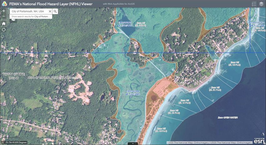
• FEMA National Flood Hazard Layer Viewer *
• NH Flood Hazards Viewer *
• GIS data available for download from FEMA Map
Service Center*
• Your community may have its own map viewer with
the FEMA floodplains shown
*For communities with digitally produced FIRMs (all NH communities except for
Town of Lincoln and communities in Belknap County). 31FEMA’s Map Service Center
https://msc.fema.gov
32FEMA National Flood Hazard
Layer Viewer
https://goo.gl/PkCRde
33NH Flood Hazards Viewer
http://bit.ly/368IBfJ
34Current FEMA
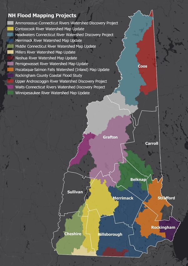
Mapping Projects
Visit NHOSI’s Current Mapping
Projects webpage for more
information:
www.nh.gov/osi/planning/programs/
fmp/current-map-projects.htm
35Rockingham County Coastal Mapping
Project
• New flood maps become
Exeter
Greenland
effective 1/29/2021 Hampton
Hampton Falls
• Affected communities Little Boar’s Head
New Castle
must adopt the maps Newfields
before the new effective Newmarket
Newington
date North Hampton
• FEMA Virtual Open
Portsmouth
Rye
House for the public on
Seabrook
Seabrook Beach
11/18 Stratham
36Headwaters Connecticut and Upper
Androscoggin Watersheds – FEMA Discovery
Project
• Virtual meeting with BERLIN
CARROLL
community officials CLARKSVILLE
COLEBROOK
on Tuesday, COLUMBIA
November 17th, DALTON
DUMMER
11am ERROL
GORHAM
• Online questionnaire
JEFFERSON
LANCASTER
MILAN
about local flood risk NORTHUMBERLAND
PITTSBURG
• Let your community’s RANDOLPH
SHELBURNE
voice be heard and STARK
STEWARTSTOWN
participate! STRATFORD
WHITEFIELD
UNINCORPORATED AREAS, COOS COUNTY
37Community Floodplain Regulations
• Adoption and enforcement of floodplain
regulations that meet minimum NFIP
requirements is required for a
community to remain in good standing
in the program.
• It is up to the community to take
ownership of their floodplain
regulations by fully understanding and
enforcing the requirements it contains.
39NFIP Minimum Regulations are a
Good Start but…
• Buildings can still suffer damage
• Do not address changes to
floodplain areas since issuance of
the FEMA map
• Do not address events greater
than 1% annual chance flood
• Do not address future conditions,
including climate change
• Communities can choose to
adopt higher standards beyond
minimum NFIP requirements
40Flood Provisions in the
State Building Code
NH State Building Code
(effective 9/15/19) includes:
– International Building Code (IBC)
2015
– International Residential Code (IRC)
2015
– American Society of Civil Engineers,
Flood Resistant Design and
Construction (ASCE 24-14)
The Codes includes flood provisions
which meet or exceed many of the
NFIP minimum standards
41Flood Provisions in the
State Building Code – Some Key
Changes
• Freeboard requirement for
residential development in Special
Flood Hazard Area (Includes all A
and V zones)
• Development in “Coastal A Zones”
must meet same building
standards as those in VE Zones.
– Learn more at OSI’s 12/15 webinar
• See our Building Code fact sheet
for more details about flood
provisions of the building code.
42Permitting for Development
All proposed development
in a Special Flood Hazard
Area shall require a local
permit.
43What is considered Floodplain
“Development”?
Any man-made change in a SFHA, including but not
limited to:
Buildings and other structures
Mining, excavation
Dredging and filling
Grading and paving
Drilling operations
Storage of equipment or materials
44Community Permitting of Floodplain
Development
• Community must have:
– A process to determine whether a
proposed development is located
in a Special Flood Hazard Area.
– A permit process for all
development not just buildings.
– A process to ensure finished
development complies with the
community’s regulations.
– An enforcement process to address
non-compliance/violations.
45Administrative Procedures for
Floodplain Development
• Effective implementation of regulations
helps minimize future flood damage
and helps keep insurance rates
affordable for property owners.
• Established administrative and
permitting processes are key tools to
ensure:
– Adherence
– Consistency among staff/staff turnover
– Good standing in NFIPOther Permits
• Applicant: Must secure other required permits and
approvals BEFORE a permit for floodplain
development is granted.
• Local Floodplain Manager should know applicable
Federal and State regulatory programs.
47General Construction
Requirements
All new construction/substantial
improvements:
• Designed (or modified) and
adequately anchored to prevent
flotation, collapse, and lateral
movement.
• Constructed with flood-
resistant materials.
• Use methods and practices to
minimize flood damage.
48Utility, Water & Sewer Requirements
• Utilities should be
designed and/or located so
as to prevent water from
entering or accumulating
within the components
49Lowest Floor
In Zones A, AE, and AO
• The top of the lowest floor
must be elevated to the Base
Flood Elevation or higher (if
community enforces higher
standard). State Building Code requires
Lowest Floor be elevated at
least 1 ft above BFE
50Lowest Floor
In Coastal High Hazard Areas (Zone VE):
• Buildings must be elevated on pilings/columns with
the bottom of lowest horizontal structural member of
the lowest floor elevated to the Base Flood Elevation
or higher(if community enforces higher standard).
Lowest
Floor State Building Code requires
Lowest Horizontal Structural Beam Lowest Floor be elevated at
least 1 ft above BFE
BFEDevelopment in Zone A with No BFE
If no BFE is available:
• Recommend requiring lowest
floor to be elevated at least
2 feet above highest adjacent
grade – See state model
ordinance language
• This is directly related to how
the structure will be rated for
insurance purposes.
52Enclosures Below Lowest Floor
• Enclosures under the lowest
floor are allowed, but must:
1. Be used solely for storage,
building access, or parking;
2. Not be below grade on all sides
(a basement); and
3. Meet NFIP requirements
related to flood openings
• When all 3 enclosure criteria
are met, what is considered
the lowest floor changes
53Enclosures Below the Lowest Floor
In Coastal High Hazard Areas
(Zone VE):
• The space below the lowest
floor must:
– be free of obstructions; or
– constructed with non-
supporting breakaway walls,
open lattice-work, or insect
screening, and be used only for
parking, building access, or
storage.What is Considered a Basement?
BFE
Grade
Basement or Crawlspace
Lowest
Floor
Any area of a building having its floor below grade on all sides.
55Basements for new construction or substantial
improvements in a Special Flood Hazard Area are
prohibited.
BFE
Grade
Basement or Crawlspace
Lowest
Floor
56Flood Openings in Enclosures
• Great resource: FEMA
Technical Bulletin #1
Updated in March
57
2020Non-Residential Structures
• Have the option to:
– Elevate the Lowest
Floor to or above the
Base Flood Elevation
OR
BFE
– Floodproof (make
watertight) the walls
of the structure up to Top of Floodproofing
or above the Base
Flood Elevation
State Building Code requires Lowest Floor be elevated 1 to 2 ft above BFE
depending on use of building 58As-Built Elevation Data
Requirements
As-built elevation data for all new
construction and substantial
improvements must be provided by
applicants following construction.
• FEMA Elevation Certificate
– Recommended for meeting this
requirement
– Also used to rate a Flood Insurance
Policy
• FEMA Floodproofing Certificate
– For floodproofed non-residential
structures only
59What is a Substantial
Improvement?
The total costs of any improvements (whether
within existing footprint or not, including
additions) to a structure are greater than or
equal to:
50% of the market value of the structure before
the start of construction of the improvement.
60What is Substantial Damage?
The total costs of restoring the structure to its
before-damaged condition (damage not limited just to flood) are
greater than or equal to:
50% of the market value of the structure before the damage occurred.
61Substantial Improvement &
Damage Determinations
• Determination must be made by
community
– Must review proposed costs for all
improvements and repairs submitted
by applicant
– Determine market value of structure
only
• If substantially improved or damaged,
structure must be brought into compliance
with community’s floodplain regulations as
if it is new construction. 62Manufactured Home Requirements
• Must be elevated on
permanent foundation
with lowest floor at or
above Base Flood
Elevation
• Be securely anchored
63Recreational Vehicle Requirements
• Allowed if on-site for
fewer than 180
consecutive days, or
• Fully licensed and ready
for highway use
o No structures
attached to RVs
• If not, must comply with
manufactured home
requirements
64Floodway Requirements
Mapped Floodways:
• No development allowed within the
floodway unless:
– Engineering analyses provided by applicant
show the proposed development would not
cause ANY increase in BFE.
Unmapped Floodways within Zone AE (A1-30):
• No development allowed unless:
– The applicant provides analyses that show the
cumulative effect of the proposed
development, when combined with all existing
and anticipated development, will not increase
the BFE more than 1 foot at any point within
the community.
65Variances
• Grant of relief by a community from the
terms of floodplain management
regulations.
• Granting variances is a local decision
that must be based on 3 NFIP variance
criteria and 5 state variance criteria.
• Variances put people and property at
risk and are not advised.
• If you do issue a variance,
documentation is your community’s only
protection after a flood that causes
damages.
66Key Takeaways
• Become familiar with your community’s flood
maps and Flood Insurance Study report.
• Know how to make a Base Flood Elevation (BFE)
determination or know the resources to use to do
so.
• Check out NH’s Flood Hazards Viewer.
• Participate in and stay informed of any FEMA
mapping projects happening in your community.
68Key Takeaways
• Have an effective permit and enforcement
process for all development in a Special Flood
Hazard Area (SFHA).
• Develop administrative procedures to ensure
adherence, consistency, and maintain NFIP good
standing.
• Understand the floodplain regulations and get
familiar with the guidance resources available.
• Contact NHOSI’s Floodplain Management
Program for assistance.
69For More Information
• Resources Guide
• NHOSI Floodplain
Management Program
website:
www.nh.gov/osi/planning/
programs/fmp
• Flood Lines Quarterly
Newsletter
• Participate in future
trainings
• Contact us - We’re here to
help!
70Reminder: Flood Maps Are
Changing Webinar Series
Flood Maps Are Changing Webinar #4
December 15th, 10:00 -11:30 am:
Webinar #4 – What to Know About Building in Coastal A and VE
Zones
Communities that have VE and/or Coastal A Zones on the new
maps: Hampton, Hampton Falls, Little Boar’s Head, New Castle,
North Hampton, Rye, Seabrook, Seabrook Beach.
71Contact Information
Jennifer Gilbert
State NFIP Coordinator
NHOSI
603-271-1762
Jennifer.R.Gilbert@osi.nh.gov
Samara Ebinger
Assistant Coordinator
NHOSI
603-271-1755
Samara.M.Ebinger@osi.nh.gov
72You can also read