EAGER-Japan - Portal deutsche Forschungsschiffe
←
→
Page content transcription
If your browser does not render page correctly, please read the page content below
BERICHTE AUS DEM MARUM UND DEM FACHBEREICH GEOWISSENSCHAFTEN
                   DER UNIVERSITÄT BREMEN

                       EAGER-Japan

 Extreme events Archived in the Geological Record of Japan’s
                     Subduction margins

             Yokohama (Japan) – Yokohama (Japan)
                   04.10.2016 – 02.11.2016,

 Strasser, M. (Co-Chief Scientist), Kopf, A. (Co-Chief Scientist),

     and Shipboard Science Parties Leg SO251-1 & SO251-2

                                          RV Sonne
                                          cruise

                                          SO251

                               2016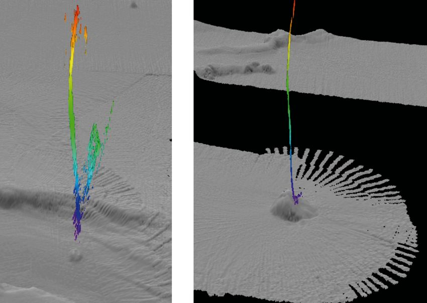
Table of Contents

1    Summary / Zusammenfassung ............................................................................ 3

2    Participants ............................................................................................................ 9

3    Narrative of the cruise......................................................................................... 13

4    Aims of the cruise ............................................................................................... 17

5    Agenda of the cruise ........................................................................................... 18

6    Setting of the working areas .............................................................................. 19

7    Work details and first results ............................................................................. 26

8    Acknowledgements ............................................................................................. 33

9    References ........................................................................................................... 34

10   Abbreviations....................................................................................................... 37

11   Appendices .......................................................................................................... 38
     I.         Participating institutions ....................... Fehler! Textmarke nicht definiert.
     II.        Station lists ............................................ Fehler! Textmarke nicht definiert.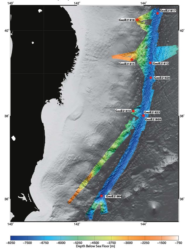
1 Summary
At the southeastern edge of the Eurasian Plate, Japan hosts two of the most interesting
subduction systems, both prone to devastating megathrust earthquakes: The Japan Trench
(JT) east of Honshu with subduction erosion/subsidence in the north, and the Nankai Trough
(NT) with a huge accretionary prism in the southwest. In 2011 the JT area was struck by a
Magnitude 9 earthquake that caused unusually large slip all the way to the trench, and a
series of landslides, which are believed to be partly responsible for amplification of the
catastrophic tsunami following the event. At Nankai, frequent M8+ earthquakes are also
documented, and landslides and other sediment remobilization processes related to
seismicity are attested. Despite the fact that either area has recently been the target of both
IODP drilling (Exp343 vs 332/333/338/348) and MARUM cruises (SO219A vs. SO222),
remaining gaps in knowledge remain and are addressed in EAGER-Japan by (i)
characterization and precise dating of extreme event layers, (ii) recovery of long-term
instruments monitoring physical triggers to such events, and (iii) study geochemistry and fluid
flow and link them to mass wasting in order to determine recurrence time and assess risk in
two key scenarios: The mega-earthquake super-cycle in the subsiding, highly segmented
Japan Trench, and records of megasplay slip in the Nankai region.
By 01 October 2016, co-chief scientist Michael Strasser and all 29 scientists from 10
different universities or research institutions safely arrived in Yokohama, Japan, and
embarked research vessel Sonne on Oct 1st. Unfortunately, our scientific equipment, which
was shipped from Bremen by a carrier that declared insolvency while the containers were
on their way to Yokohama, did not arrive. Nevertheless, and thanks to the great
support by our Japanese colleagues from JAMSTEC (Japan Agency for Marine Earth
Science and Technology), the Geological Surveys of Japan, and the University of
Tokyo, as well as the PfJ (Projektträger Jülich) that kindly provided coring and laboratory
equipment for our research cruise on very short notice, given that individual scientists also
brought equipment to Yokohama in their luggage, we could start our voyage with nearly
complete infrastructure. With a delay of 2 ½ days RV Sonne left the harbor on Tuesday Oct.
4 at 15:00. The additional time in port was used for science meetings and discussions to
optimize work flows on deck and in the laboratory using the various „new“ equipment and to
prepare for our „EAGER-Japan“ expedition.
The first research area northeast of Honshu was reached after 17hrs of transit. After some
initial Multibeam and Parasound mapping the first piston core was taken in the deepest
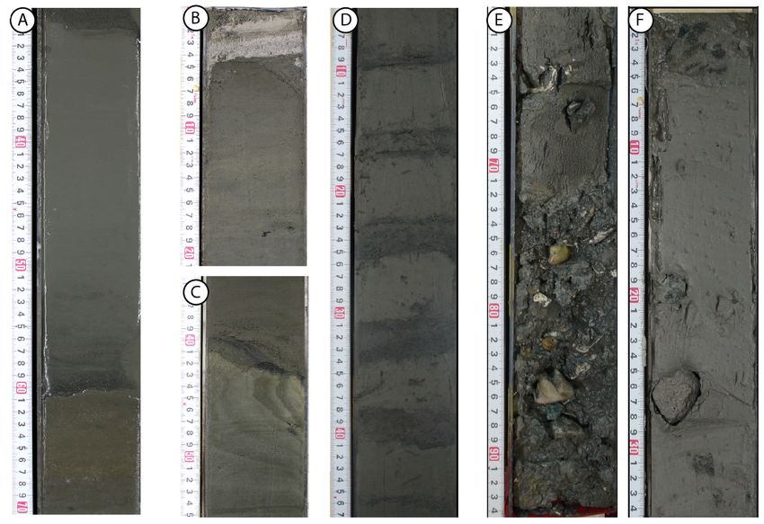
portion of the Japan Trench in 8000m water depth, so that the workflow for core description
and analysis (fluid geochemistry, core description and photography, sediment physical
properties, and smear slide microscopy) could be implemented. Over the following days,
RV SONNE sailed northward and we took an additional three 10m long piston cores in the
trench plus two 5m long cores at the slope, which slipped coseismically seaward during the
2011 earthquake.
At 40.3°N latitude, in the northernmost Trench Basin within the Japan Trench, a 10m
piston core provided insights into large mass wasting events along the northern portion oft he
subduction zone (the so called Sanriku segment). We further took a 5m double core on the
continental slope, one of which was analysed in the shipboard laboratory while the other is
sent to MARUM Bremen for geotechnical tests that simulate deformation behaviour when
3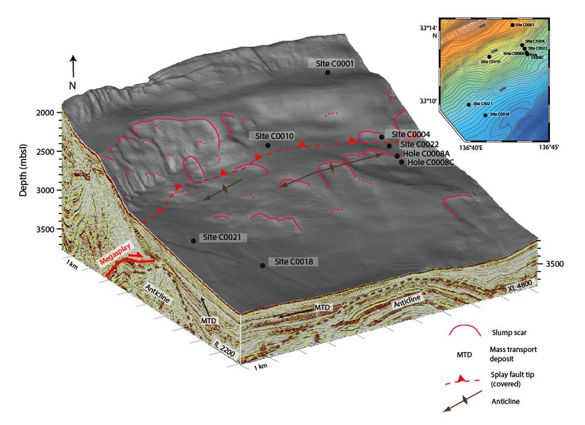
Report and preliminary results of SO251

dynamic loads are applied to the sediment, as is the case during large EQs. These data help
to understand at which stresses (or EQ magnitudes) mass wasting into the trench occurs, a
piece of information which will allow us to unravel the geological archive of previous seismic
events in the Japan Trench. Leg SO251-1 ended on 15 Oct 2016 in Yokohama, and the
initial results of the various groups on board clearly attest that the fingerprint of the 2011
Tohoku event is still visible in some places.

   After the arrival of additional air cargo, we further used the port call for the setup of the
heat flow probe and ROV PHOCA, both sent by our colleagues at GEOMAR. In Yokohama
we also hosted various delegations of scientists from JAMSTEC and CDEX on RV SONNE,
and a team of GOOGLE Culture made videos so that a virtual ship’s tour will be possible on
the internet in the near future. On 18 Oct 2016 RV SONNE departed for mission SO251-2
towards the Nankai Trough area. The science team was partly exchanged to meet the new
requirements (e.g. ROV surveys) and Achim Kopf served as co-chief of the team of 34
persons from 10 nations.

    The scientific programme began with HF measurements across active mud volcano as
well as along a transect in the Kumano basin, which complemented results from the earlier
cruise SO222 and, in the case of MV13, gave elevated temperature values – a hint towards
fluid mobilisation from depth. The first dive with ROV PHOCA was on MV2, where we
identified recent mud flows, with the maximum activity being well characterised using the T-
stick (ROV-held miniature T probe) in the SW summit region. Here, living clams, bacterial
mats and clasts of several dm diameter were observed. Indicators for gas seepage, as
suggested from the mousse-like texture of some sediment cores, will further be constrained
by shore based methane analysis. In some cores we found mud breccia while others had
primarily hemipelagic background sediment, rarely intercalated with materal which could be
interpreted as mud flow deposit. Pore waters from some oft he cores appeared to be slightly
freshened (i.e. 80-90% SW salinity) and point towards a possible deep-seated fluid source.

   The next dives of ROV PHOCA were dedicated to the localisation and recovery of the
MeBo-borehole observatories. In the summit region of MV3 we found only one of the two
observatories, while on MV4 both instruments were located quickly. Given that the
connection to the drillstring (hotstab) was too tight for ROV PHOCA to loosen it, we tried to
unscrew both the observatory and underying MeBo drill rod. Despite the rather unstable
weather we managed to do four more ROV dives during the final week of the expedition. The
very demanding work on the seafloor finally resulted in the successful recovery of all P-T
instruments deployed in 2012. The post-cruise analysis of the time series data of P and T in
the boreholes will hopefully allow us to test if there is a link between these physical
parameters and the regional seismic activity offshore Japan. The geophysical mapping and
profiling between the dives enabled us to discover new mud volcanoes, but also > 40 flares,
a number quite unexpedcted given the rather slow seepage activity during the 2012 survey.
Fluid seepage is not restricted to the mud volcanoes, but also along the seafloor outcrop oft
he so called Megasplay fault of the Nankai accretionary complex near the seaward border of
the Kumano Basin.

  During the station work we further acquired a number of seismic profiles and also cores to
enhance the understanding of stratigraphy, geodynamic and sedimentary activity of the
   4
Report and preliminary results of SO251

Kumano Basin, and what role the event layers in these data may play. Given that the
Japanese piston coring technician was no longer on board, some of that work is based on
cores taken with an improvised corer we mounted to the HF probe – a device that gained us
6 additional cores. One of those was taken outside of MV2 on the surrounding Kumano
Basin floor. Both heat flow data as well as sediment characteristics point towards recent
mudflow deposits. In addition, differential bathymetry provides constraints that the mud flows
occurred between summer 2012 (SO222 cruise) and SO251 4½ years later. Postcruise
geochemical analysis will try to date the exact time of mud extrusive activity.

   Sediment physical properties data from the Nankai slope seaward oft he Kumano Basin
served to assess the strength and stability of the deposits and compare them to those
recovered from the slopes of the Japan Trench region (Leg SO251-1). Such slope deposits
undergo so called seismic strengthening, where particles move closer together as a result oft
the dynamic displacement of pore water, thereby incraesing the bonding forces. Our
preliminary data imply that the strength of the JT samples is higher than that of material from
Nankai.

   On 01 Nov 2016 RV SONNE had to depart from the Nankai area in the afternoon and
docked in Yokohama in the early morning of 02.11.2016, where Expedition SO251 ended.
Despite the container problems and improvised operationsall key objectives of the cruise
were achieved. We want to underline that such a success would not have been possible
without the support of the Japanese institutions, GEOMAR, and financial help by BMBF/PtJ.

  Zusammenfassung
Am Südostrand der Eurasischen Platte beherbergt Japan zwei kontrastierende, seismisch
hochaktive Subduktionszonen: Den Japangraben nahe Honshu mit Subduktionserosion im
Norden und den Nankaitrog-Akkretionskomplex im Südwesten. Im März 2011 erschütterte
ein Erdbeben der Magnitude (M) 9 den Japangraben, das über 50 m Horizontalversatz am
Tiefseegraben verursachte und zahlreiche Nachbeben, Rutschungen und verheerende
Tsunamis auslöste. Im Nankaitrog treten M>8-Erdbeben regelmässig auf, welche ebenfalls
mit Massenbewegungen und Tsunamis verknüpft sein können. Ungeachtet der jüngsten
Kampagnen von IODP (Exp343 vs. 332/333/338/348/365) bestehen massive Lücken im
Verständnis der Steuerfaktoren dieser Extremereignisse. Wissenschaftlicher Fortschritt
konnte auf zwei kürzlich durchgeführten MARUM-Expeditionen (SO219A vs. SO222) erzielt
werden, die 2012 stattfanden und auf deren Erkenntnissen die Expedition SO251 aufbaute.
Die Fahrtziele waren folglich: (i) Charakterisierung und Datierung der Lagen solcher
Extremeregnisse, (ii) Bergen der bei SO222 ausgebrachten Langzeit-Observatorien, die
physikalische Kontrollparameter solcher Extremeregnisse zeigen, und (iii) geochemisches
und    hydrogeologisches     Studium    der    Event-Lagen    zur    Bestimmung     von
Wiederkehrintervallen und Risiken in zwei Szenarien: Dem Starkbeben-Superzyklus im
segmentierten Japangraben, und der Megasplay-Bewegungen in Nankai.

  Am 01. Oktober waren Fahrtleiter Prof. Dr. Michael Strasser der Univ. Innsbruck und
weitere 28 Wissenschaftler/innen     aus   10    verschiedenen    Universitäten  oder
Forschungseinrichtungen, wohlbehalten in Yokohama, Japan, eingetroffen und an Bord
von FS SONNE gegangen. Leider traf dies nicht auf die Ausrüstung zu, die in sechs
                                                                                              5
Report and preliminary results of SO251

Containern auf zwei unterschiedlichen Schiffen einer großen Reederei unterwegs waren, die
soeben Insolvenz angemeldet hatte. Zwei Wochen vor Expeditionsbeginn wurde klar, daß
weder die Ausrüstung zu Abschnitt SO251-1 (Japangraben) noch 251-2 (Nankaitrog)
fristgerecht in Japan zu erwarten sei. Somit war es nur dank der großartigen
Unterstützung unserer Japanischen Kollegen von JAMSTEC (Japan Agency for Marine
Earth Science and Technology), des Geologischen Dienstes von Japan, der Universität
Tokyo, sowie des PtJ möglich, kurzfristig ein Kolbenlot zur Kernentnahmegeräte und
Laborgeräte für Abschnitt SO251-1 bzw. eine Wärmestromlanze und ein ROV für Abschnitt
SO251-2      zu   Verfügung    stellen. Alle übrigen Utensilien brachten die jeweiligen
Wissenschaftler statt persönlichen Gepäcks mit, so daß FS SONNE lediglich mit einer
kleinen Verzögerung und letztlich einer kompletten, wenn auch improvisierten
wissenschaftlichen Ausrüstung am 04.10.2016 auslaufen konnte.

   Das Arbeitsgebiet des ersten Fahrtabschnitts im Japangraben, nordöstlich von
Honshu, wurde nach knapp 17h Transit erreicht. Nach ersten Vermessungsarbeiten mit
Multibeam und Parasound haben wir noch am ersten Tag im Arbeitsgebiet an der tiefsten
Stelle des Japangrabens in über 8000m Wassertiefe einen Kern mit dem JAMSTEC-
Kolbenlot gezogen, und danach den Workflow der Kernanalysen in den Laboren
(Porenwassergeochemie,     Kernbeschreibung und -fotografie, geotechnische           und
physikalische Sedimenteigenschaften und „Smear Slide“ Mikroskopie) in Gang gesetzt.
Im Verlauf der ersten Woche arbeite sich FS SONNE bis ins nördliche Studiengebiet vor und
gewann weitere drei 10m-Kerne im Tiefseegraben sowie 2 Kerne am untersten Hang, der
sich währende des Erdbebens 2011 koseismisch ruckartig um mehere 10-er Meter seewärts
bewegte.

   Auf 40.3° nördlicher Breite, im nördlichsten Trench‐Becken des Japangrabens,
zogen wir einen       Langkern,     der    uns   spannende     Einblicke   in    grosse
Sedimentumlagerungsereignisse      entlang   der  nördlichen   Subduktionszone (dem
sogenannten Sanriku Segment) liefert. Zudem gewannen wir dort weitere Doppel‐Kerne am
Kontinentalabhang, die in den Schifflaboren und später in den Gesteinsphysik-Laboren
der Forschungsgruppe für Marine Geotechnik am MARUM Bremen auf Sedimentfestigkeit
und Deformationsverhalten unter Einwirkung dynamischer Spannungen, wie sie bei
Grosserdbeben wirken, untersucht werden. Daraus läßt sich nach der Expedition generisch
ableiten, bei welchen Erdbebenerschütterungen Sediment vom Abhang in den
Tiefseegraben transportiert wird. Mit diesen Erkenntnissen werden wir das geologische
Archiv vergangener Erdbeben im Japangraben quantitativ auf die Stärke vergangener
Erdbeben analysieren können.

   Der erste Abschnitt von SO251 endete am 15.10.2016 in Yokohama, und von den ersten
Resultaten der verschiedenen Gruppen zeichnet sich klar ab, dass der geologischen
Fingerabdruck des Tohoku‐Erdbebens von 2011 in den verschiedenen Datensätzen
identifizierbar ist und die Daten spannende Aussichten auf Erkenntnisgewinne über die mit
Erdbeben in Verbindung stehenden Prozessen am und im Meeresboden versprechen.

   6
Report and preliminary results of SO251

   Nach Eintreffen weiterer Ausrüstung per Luftfracht wurde der Hafenstopp genutzt, um die
Inbetriebnahme der Wärmestromlanze sowie des Tauchroboters PHOCA unserer Kollegen
des GEOMAR durchzuführen. In Yokohama besuchten zudem mehrere Delegationen von
JAMSTEC und CDEX das Schiff, und ein Team von GOOGLE Culture machte Aufnahmen,
so daß demnächst ein virtueller Schiffsrundgang auf SONNE im Internet möglich sein wird.
Am 18.10.2016 lief SONNE frühmorgens zu SO251-2 in den Nankaitrog aus. Die
wissenschaftliche Mannschaft wurde den Bedürfnissen im zweiten Arbeitsgebiet angepasst
und die Fahrtleitung wechselte zu Achim Kopf, Professor für Marine Geotechnik am MARUM
Bremen. Das internationale wissenschaftliche Team besteht fortan aus 34 Personen aus 10
Ländern.

   Die wissenschaftliche Arbeit startete mit Wärmestrommesssungen über einen
Schlammvulkan und entlang eines Langprofils im Kumanobecken, was Ergebnisse von
SO222 komplementierte und im Fall des Schlammvulkans MV13 erhöhte Werte lieferte – ein
Indiz für Fluidmobiliserung aus der Tiefe. Auch der erste Tauchgang des ROV PHOCA war
auf einem Schlammvulkan, wo wir verschieden jüngere Schlammaustritte fanden und per
Messungen mit T-stick (einer kleinen Temperaturlanze) die aktivste Region am Kraterbereich
im Südwesten belegten. Der Gipfelbereich zeigte lebende Muscheln, Bakterienmatten und
auch Klasten bis einige Dezimeter im Durchmesser. Indizien für Gasaustritte fanden sich auf
verschiedenen Schlammvulkanen die mit erhöhten Methangehalten in den Kernen (zunächst
makroskopisch abgeleitet anhand der Blasigkeit der Sedimente; Analysen werden erst in
Bremen vorgenommen). In einigen der Kerne fanden sich Schlammbrekzien, in anderen
primär hemipelagische Hintergrundsedimente oder aber Einschaltungen, die als
Schlammstromablagerung gedeutet werden könnten. Genauere Interpretationen bedürfen
des Studiums in den Heimatlaboren. Die Porenwässer sind leicht ausgesüsst (d.h. 80-90%
Meerwasser-Salinität) und deuten auf Mobilisierung tief im Akkretionskeil.

   Die beiden nächsten Tauchgänge von ROV PHOCA dienten der Lokalisierung und
Bergung der MeBo-Bohrlochobservatorien. In der Gipfelregion von MV3 wurde nur eines der
beiden Observatorien gefunden, während auf Schlammvulkan MV4 dagegen eines der
beiden Observatorien schnell gefunden wurde. Da die Steckverbindung (hotstab) zu
schwergängig war, gelang es den Piloten mit viel Geschick, das Observatorium samt
oberster MeBo-Bohrstange abzuschrauben. Trotz des extrem wechselhaften Wetters in der
letzten Expeditionswoche konnten wir kurze Gutwetterfenster nutzen, um weitere 4 ROV
Tauchgänge zu machen. Die ausnahmslos anspruchsvollen Arbeiten am Meeresboden
dienten dazu, alle verbliebenen MeBo-Observatorien erfolgreich abzubergen, was auch
gelang. Die Analyse der Zeitseriendaten, bei denen uns Druck und Temperatur im Bohrloch
Aufschlüsse zur Schlammvulkanaktivität im Zusammenhang mit Erdbebentätigkeit vor Japan
geben, kann im Detail erst nach der Expedition stattfinden.
Die Phasen nicht so guten Wetters nutzten wir unter anderem zur hydroakustischen
Profilaufnahme und Fächerecholot-Kartierung. Hierbei entdeckten wir zwei neue
Schlammvulkane. Analysen der Wassersäulensignale zeigten uns zudem, daß im
Arbeitsgebiet derzeit über 40 Flares zu sehen sind. Die Fluidaustritte sind keineswegs auf
die Schlammvulkane beschränkt, sondern finden sich beispielsweise auch am
Meeresbodenausbiss prominenter Störungen wie der sog. Megasplay Fault des Nankai
Akkretionskomplexes.
Im Verlauf der Stationsarbeiten nahmen wir auch entscheidende reflectionsseismische
(Parasound) Profile und Kerne zur Stratigraphie, die geodynamische und sedimentologische
Aktivität des Kumano Beckens entschlüsseln helfen und Eventlagen von großen Erdbeben
                                                                                            7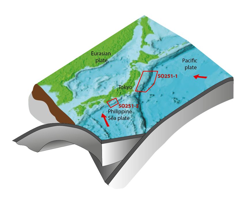
Report and preliminary results of SO251

und Massenumlagerungen beinhalten. Da der japanische Kolbenlottechnker nicht mehr an
Bord war, bauten wir zum Kernen ein improvisiertes Gerät, das die Wärmestromlanze als
Träger nutzte und uns weitere fünf Sedimentkerne lieferte. Bei den Arbeiten auf
verschiedenen Schlammvulkanen attestieren uns sowohl Wärmestrom als auch
Wärmeleitfähigkeit und andere Sedimentparameter grosse Schlammausströme am MV2.
Diese Schlammaustritte müssen in den vergangenen 4 Jahren platzgenommen haben, da
sie bei der vorherigen Expedition SO222 nicht vorlagen. Eine differentielle bathymetrische
Karte unterstützt dieses Ergebnis, weil um den gesamten Schlammvulkan Materialzufuhr zu
finden ist. Wir versuchen über chemische Analysen zu ermitteln, wann genau diese
voluminösen Ausflüsse stattfanden und mit welchen Prozessen sie im Zusammenhang
stehen.
   Parallel zum Studium des Kumanobeckens nutzen wir sedimentphysikalische Messungen
am Hang des Nankai-Akkretionskeils, um die Scherfestigkeit und andere
stabilitätsbeschreibende Parameter mit Ergebnissen des Japangrabens (erster Abschnitt
SO251-1) zu vergleichen. Hangsedimente beider Ränder unterliegen offenbar sog. Seismic
strengthening, einer erhöhten Festigkeit wegen der wiederholten dynamischen Belastung
und effektiven Verdrängung des Porenwassers. Unsere vorläufigen Daten suggerieren, daß
die Verfestigung im Japangraben stärker ist als in Nankai.

   Am 01.11.2016 verließ SONNE nachmittags den Nankaitrog und erreichte am 02.11.2016
Yokohama, wo die Expedition SO251 endete. Letztlich wurden trotz der Containermisere und
viel Improvisation alle Arbeiten mit guten Erfolg durchgeführt und die Kernziele des Projekts
erreicht. Herauszuheben ist an dieser Stelle nochmals die hervorragende Unterstützung von
vielen Seiten, die das Fehlen der Ausrüstungscontainer überwinden halfen, namentlich durch
PtJ/BMBF für die zusätzlichen kurzfristigen Transporte sowie die japanischen Institute und
Kollegen.

   8
Report and preliminary results of SO251

2             Participants
2.1 Participants (scientific party)

Leg SONNE251-1, Yokohama - Yokohama, 04.10.2016 – 15.10.2016

NAME                                  Discipline                    Institution

STRASSER, Michael                     Chief Scientist               UIBK / MARUM
BACHMANN, Anna Katharina              Hydroacoustics                MARUM
DOS SANTOS FERREIRA, Christian        Hydroacoustics                MARUM
FLEISCHMANN, Timo                     Coring / Lab                  MARUM
FUJIWARA, Toshiya                     Hydroacoustics                JAMSTEC
HILLMAN, Jess Irene Tsahai            PhysProps                     GEOMAR
HOEHNE, Mareike                       PhysProps                     MARUM
IKARI, Matt                           PhysProps                     MARUM
IKEHARA, Ken                          Sedimentology                 GSJ / AIST
JAEGER, Fabian Dominik                Coring / Lab                  UIBK
KANAMATSU, Toshiya                    Sedimentology/Coring          JAMSTEC
KIOKA, Arata                          Hydroacoustics                AORI / UIBK
KOELLING, Martin                      Geochemistry                  MARUM
LANGE, Karl                           Hydroacoustics                MARUM
LUEBBEN, Neeske                       Geochemistry                  MARUM
MCHUGH, Cecilia Maria                 Sedimentology                 Queens Coll. / Lamont
MOERNAUT, Jasper                      Hydroacoustics                UIBK
MOLENAAR, Ariana                      Sedimentology                 UIBK
NAKANO, Yukihiko                      Coring                        MWJ / JAMSTEC
REX, Marie                            Lab                           MARUM
ROESNER, Alexander                    PhysProps / Coring            MARUM
SCHWESTERMANN, Tobias                 Hydroacoustics                UIBK
SUN, Tianhaozhe                       Hydroacoustics                PGS
SZCZUCINSKI, Witold                   Sedimentology                 University of Poznan
TOECHTERLE, Paul                      Geochemistry                  UIBK
TRUETNER, Sebastian                   PhysProps                     MARUM
USAMI, Kazuko                         Sedimentology                 GSJ / AIST
WIEMER, Gauvain                       PhysProps                     MARUM
YAMAGUCHI, Asuka                      Sedimentology                 AORI

                                                                                          9
Report and preliminary results of SO251

Leg SONNE251-2, Yokohama - Yokohama, 18.10.2016 – 02.11.2016

   NAME                                   Discipline                  Institution

   KOPF, Achim                            Chief Scientist             MARUM
   ABEGG, Friedrich Werner                ROV                         GEOMAR
   BACHMANN, Anna Katharina               Hydroacoustics              MARUM
   CUNO, Patrick                          ROV                         GEOMAR
   DOS SANTOS FERREIRA, Christian         Hydroacoustics              MARUM
   FLEISCHMANN, Timo                      Coring/HF/Observatories     MARUM
   HATAKEYAMA, Ei                         Coring                      MWJ / JAMSTEC
   HEESEMANN, Bernd Reinhardt             Heat Flow                   MARUM
   HOEHNE, Mareike                        PhysProps                   MARUM
   HUUSMANN, Hannes                       ROV                         GEOMAR
   JAEGER, Fabian Dominik                 Coring/Sedimentology        UIBK
   KANG, Min-Hua                          ROV trainee                 Taiwan (ROC)
   KAUL, Norbert Emanuel                  Heat Flow                   MARUM
   KIOKA, Arata                           Hydroacoustics              AORI / UIBK
   LANGE, Karl                            Hydroacoustics              MARUM
   LUEBBEN, Neeske                        Geochemistry                MARUM
   MATTHIESSEN, Torge                     ROV                         GEOMAR
   MEIER, Arne                            ROV                         GEOMAR
   MENAPACE, Walter                       Sedimentol./Observatories   MARUM
   MOCHIZUKI, Kenta                       Coring/Sedimentology        Yamaguchi Univ.
   MOERNAUT, Jasper                       Hydroacoustics              UIBK
   MOLENAAR, Ariana Willemina             Sedimentology               UIBK
   MOORE, Gregory Frank                   Hydroacoustics              Hawaii Univ.
   MU, Ling-Ji                            ROV trainee                 Taiwan (ROC)
   PIEPER, Martin                         ROV                         GEOMAR
   REX, Marie Luise Pia Alina             Heat Flow                   MARUM
   ROESNER, Alexander                     Observatories / PhysProp    MARUM
   SCHWESTERMANN, Tobias                  Hydroacoustics / Sedi.      UIBK
   STRASSER, Michael                      Sedimentology               UIBK

   10
Report and preliminary results of SO251

2.2 Participants (crew)

  Leg SONNE251-1, Yokohama - Yokohama, 04.10.2016 – 15.10.2016

  NAME                                          Rank

  MEYER, Oliver                                 Master
  SOSSNA, Yves Michael                          Chief Officer
  HOFFSOMMER, Lars                              2. Officer
  BURZLAFF, Stefan                              2. Officer
  WALTHER, Anke                                 Ship's Doctor
  LEPPIN, Joerg                                 Chief Electronic Engineer
  PREGLER, Hermann Josef                        System Manager
  PLOEGER, Miriam                               System Manager
  HERMESMEYER, Dieter Karl-Heinz                Chief Engineer
  STEGMANN, Tim Wolfram                         2. Engineer
  GENSCHOW, Steffen                             2. Engineer
  HORSEL, Roman                                 2. Engineer
  ADAM, Patrick                                 Electrican
  DE BUHR, Henning                              Electrican
  BLOHM, Volker                                 Fitter
  TALPAI, Matyas                                MPC / Motorman
  MUENCH, Lothar                                MPC / Motorman
  LUEBKE, Rene                                  MPC / Motorman
  GARNITZ, André                                1. Cook
  VOGT, Alexander                               1. Steward
  CAROLINO, Bernardo Orlanda                    2. Steward
  KROEGER, Sven                                 2. Steward
  ROYO, Luis                                    2. Steward
  SCHRAPEL, Max Karl Andreas                    Boatswain
  PAPKE, Rene                                   MPC /A.B.
  KRUSZONA, Torsten Frank                       MPC / A.B.
  BIERSTEDT, Torsten                            MPC / A.B.
  VOGEL, Dennis                                 MPC / A. B.
  KOCH, Stefan                                  MPC / A.B.
  RIEGER, Willi                                 MPC / A.B.
  SPRENKEL, Sebastian                           MPC / A.B.

                                                                                    11
Report and preliminary results of SO251 Leg SONNE251-2, Yokohama - Yokohama, 18.10.2016 – 02.11.2016 NAME Rank MEYER, Oliver Master GÖBEL, Jens Christian Chief Officer HOFFSOMMER, Lars 2. Officer BURZLAFF, Stefan 2. Officer WALTHER, Anke Ship's Doctor LEPPIN, Jörg Chief Electronic Engineer PREGLER, Hermann Josef System Manager PLÖGER, Miriam System Manager HERMESMEYER, Dieter Karl-Heinz Chief Engineer STEGMANN, Tim Wolfram 2. Engineer GENSCHOW, Steffen 2. Engineer ADAM, Patrick Electrican DE BUHR, Henning Electrican BLOHM, Volker Fitter HOFFMANN, Georg MPC / Motorman MÜNCH, Lothar MPC / Motorman BOLIK, Torsten MPC / Motorman GARNITZ, André 1. Cook KOSANKE, Patrick 2. Cook VOGT, Alexander 1. Steward CAROLINO, Bernardo Orlanda 2. Steward KROEGER, Sven 2. Steward STEEP, Maik Ingo 2. Steward SCHRAPEL, Max Karl Andreas Boatswain PAPKE, Rene MPC /A.B. KRUSZONA, Torsten Frank MPC / A.B. BIERSTEDT, Torsten MPC / A.B. VOGEL, Dennis MPC / A. B. KOCH, Stefan MPC / A.B. RIEGER, Willi MPC / A.B. SPRENKEL, Sebastian MPC / A.B. 12
Report and preliminary results of SO251
3 Narrative of the cruise
Leg SO251-1, Yokohama - Yokohama, 04.10.2016 – 15.10.2016
By September 30, all 29 scientists of the SO251-A science party safely arrived in Yokohama,
Japan, and embarked research vessel Sonne on Oct 1st. Unfortunately, our scientific
equipment, which was shipped from Bremen by a carrier that declared insolvency while the
containers were on their way to Yokohama, did not arrive. Nevertheless, and thanks to the
great support by our Japanese colleagues from JAMSTEC, the Geological Surveys of Japan,
and the University of Tokyo, that kindly provided coring and laboratory equipment for our
research cruise on very short notice, we could start our voyage with nearly complete
infrastructure and a delay of 2 ½ days to leave the harbor on Tuesday Oct. 4 at 15:00.
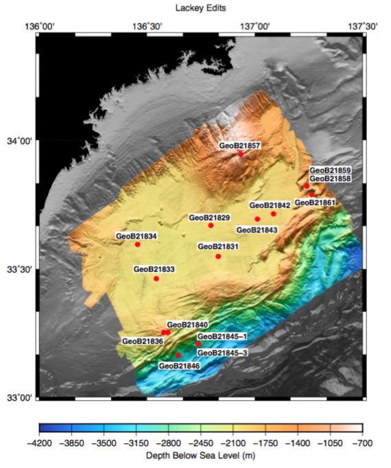
The working area of the first part of the SO251 expedition, the Japan Trench, was reached
after a transit of 17h. After a first CTD Station and two short multibeam bathymetry and
Parasound mapping surveys, we successfully retrieved a piston core (GeoB21804) from the
deepest part of the Japan Trench in more than 8000m water depth. From Wednesday Oct 5
we conducted detailed mapping and coring along the trench axis from S-N to have arrived in
the norther part of the study area by Sunday, Oct 9. Piston coring operation included
successful recovery of two nearly 10m long cores from the very deep trench basins in the
>7000km deep Japan Trench (GeoB21809 and GeoB21812). Furthermore, at stations
GeoB21810 and GeoB21815, we have sampled two sections from the slope.
Starting late evening on Sunday Oct 9 and continuing into Monday Oct 10, we acquired a
175km long East-West bathymetric profile perpendicular to the margin at 39.3°N. Followed
by detailed Multibeam and Parasound mapping along the trench axis to the North, we arrived
at the northernmost station (GeoB21817) of our expedition on Tuesday, Oct 11 to take a 10m
long core from the trench basin infill. At the same day, we also managed to obtain a double
coring of the slope sediment in the northern part (GeoB21818). On Wednesday, Oct 12, R/V
Sonne navigated back southwards, there while filling small gaps in mapping to eventually
succeed in acquiring a complete high-resolution bathymetric map of the trench axis and
nearly 2000 km of subbottom Parasound profiles, covering the entire along-strike extent of
the Japan Trench from 36° to 40.3° N. On our voyage back south there remained enough
time to take two additional cores in the deep trench (GeoB21821 and GeoB21823). On early
morning Oct 14, we finished operation of Leg SO251-A, and after the transit back to
Yokohama, the first leg ended on Saturday October 15 at 8 o’clock in the morning.
A map of the tracks covered is seen in Figure 3.1.
13Report and preliminary results of SO251 Fig. 3.1 Track chart of R/V SONNE Leg SO251-1 in the Japan Trench, including coring locations. Leg SO251-2, Yokohama - Yokohama, 18.10.2016 – 02.11.2016 RV Sonne was in Yokohama port from 15-18 October in order to load and mobilise the Heat flow probe as well as the remotely operated vehicle PHOCA of our colleagues from GEMAR Kiel. Despite the delivery of ROV PHOCA on very short notice because oft he stranded expedition equipment on HANJIN vessels, the harbour test was successful. In Yokohama we also had visits from several groups from JAMSTEC and CDEX to see RV Sonne and discuss scientific strategies. We also had a visit from GOOGLE Culture videographers, footage of which will shortly be available as a virtual ship’s tour on RV Sonne via the internet. 14
Report and preliminary results of SO251

   The SO251 science party was partly exchanged to meet the requirements in the second
study area, the Nankai Trough subduction zone. On 18.10. at 8 o’clock, RV Sonne departed
and reached the Kumano forearc basin later the same day. The scientific work started with
heat flow measurements across a mud volcano and along a N-S profile across the Kumano
Basin, which complements data from cruise SO222 in 2012. During the 3rd week of the
expedition, we had three dives with ROV PHOCA on mud volcanoes where we had placed
instruments in 2012. In the periods between diving, we carried out hydroacoustic surveys
during which we found indications for fluid seepage on mud volcanoes and other topographic
features. Cores were taken on a new MV#14, of the Kumano Basin fill, and other MVs. On
Oct 23 we hit bad weather conditions and decided to head for Yokohama again where a
Japanese coring technician had to depart.

  Fig. 3.2    Track chart of R/V SONNE Leg SO251-2 in the Nankai Trough area, including coring
                                           locations.

                                                                                                 15
Report and preliminary results of SO251
When back in the study area again on Oct 24, the weather had improved and heat flow,
geophysical surveys and ROV operations continued. The final week of SO251 started with
the successful recovery of a MeBoPLUG observatory and T-stick (GeoB21853) as well as
the recovery of the SmartPlug-piezometer. Since the geophysical acquisition allowed us to
identify new, previously unknown sites of flare activity, we also converted the heat flow probe
as coring device and from Oct 29 onwards then sampled the seafloor again on suspected
MV sites, an isolated pond, and the Nankai slope outboard of the splay fault.
On subsequent dives, we also recovered a second set of MeBoPLUG observatory and T-
stick (GeoB21856) as well as the most precious observatory, a MeBoCORK-A by using a
second wire. This final dive on Oct 31 terminated the observatory recoveries and shifted the
focus towards coring and mapping again. All station work was very successful and the main
goals of the cruise were reached. For tracks covered during leg SO251-2, refer to Figure 3.2.
On Nov 01 at appx. 14.30h we finally departed from the study area and steamed towards
Yokohama a third and final time. RV Sonne met the pilot at 5 a.m. on Nov 02 and docked
about 2.5 hrs later.
16Report and preliminary results of SO251
4 Aims of the Cruise
The overarching goal of RV Sonne cruise SO251 and subsequent post-cruise research
is to investigate fluid- and sediment mobilisation processes by mud volcanism, earthquake-
triggered seafloor displacement, submarine landslide and related “paleoseismologic event
deposits” and to compare inferred earthquake processes and rates along accretionary vs.
erosive subduction margins of Japan (Nankai Trough and Japan Trench, respectively).
The goals lie within four research categories, namely:
1. Deep Water coring in the Japan Trench and Nankai Trough to unravel
paleoseismological records,
2. ROV dives to recover seafloor and sub-seafloor instruments in the Kumano Basin
mud volcanoes,
3. Detailed high resolution seafloor surveys by ROV and accompanied coring on
the continental slope and on mud volcanoes, and
4. Sedimentological and Geotechnical post-cruise analysis and integration of all
data, including those from cores, waters, and long-term instruments.
17Report and preliminary results of SO251
5 Agenda of the cruise
The work program was divided into two parts: Leg 1 conducted mapping and coring along
the deep Japan Trench and along the upper slope and forearc escarpment from 36°N to
40°N; and Leg 2 to the Kumano Basin in the NT area to pick up instruments in the mud
volcano field by ROV followed by further mapping, coring and detailed video surveying of
seafloor in the Kumano Basin, the forearc high and the shallow splay fault area. Post-cruise
science will be coordinated among the international science party (see section 2.1 above).
With SO251 we will establish a bathymetric and sedimentary inventory of mass-
movements, chronology of extreme-event deposits and their paleoseismologic interpretation.
It further will investigate geotechnical aspects of earthquake-triggered mass wasting
processes to allow for quantitative interpretation and comparison of the established event
catalogue. We also will illuminate the relationship between mud volcanic activity (mudflows,
seepage, etc.) and local seismicity by using long-term data, time series samples and
additional core/data from the cruise. Anticipated conceptual advance in our understanding of
sediment dynamic processes related to subduction zone earthquakes are expected to be
transformative and may well apply for other active convergent margins worldwide, not just
Japan and the circum-Pacific region.
18Report and preliminary results of SO251
6 Setting of the working areas
6.1 Overall geological and tectonic setting of the two study areas
At the southeastern edge of the Eurasian Plate, Japan hosts two of the most interesting
subduction systems, both prone to devastating megathrust earthquakes: The Japan Trench
(JT) east of Honshu with subduction erosion/subsidence in the north, and the Nankai Trough
(NT) with a huge accretionary prism in the southwest (Fig. 6.1). In 2011 the JT area was
struck by a M9 earthquake that caused unusually large slip all the way to the trench, and a
series of landslides, which are believed to be partly responsible for amplification of the
catastrophic tsunami following the event. At Nankai, frequent M8+ earthquakes are also
documented, and landslides and other sediment remobilisation processes related to
seismicity are attested. Despite the fact that either area has recently been the target of both
IODP drilling (Exp343 vs 332/333/338/348/365), and MARUM cruises (SO219A vs. SO222)
gaps in knowledge about causes and consequences of submarine earthquake, landslides
and tsunamis remain. Advancing science with respect to this research themes is addressed
in EAGER-Japan by (i) characterization and precise dating of extreme event layers, (ii)
recovery of long-term instruments monitoring physical triggers to such events, and (iii) study
geochemistry and fluid flow and link them to mass wasting in order to determine recurrence
time and assess risk in two key scenarios: The mega-earthquake super-cycle in the
subsiding, highly segmented Japan Trench, and records of megasplay slip in the Nankai
region.
Fig. 6.1: Plate tectonic situation
below Japan and outlines of
working areas of SO251-1, and -2.
Red arrows show plate movement
direction of Pacific and Philippine
Sea plate (Figure after Miller, 2008).
Japan Trench
Along the Japan Trench lower Cretaceous (~130 Ma) Pacific oceanic crust subducts
below Japan in a west-northwest direction at an average rate of about 8 to 8.5 cm/year
(Figure 6.1; DeMets et al., 2010). The bulk of the forearc is composed of Cretaceous
accreted strata (Tsuru et al., 2000) discordantly overlain by thick forearc basin fills and
thinner slope apron sediments. The sedimentary strata in the upper part of the forearc basin
19Report and preliminary results of SO251 and slope apron Neogene-to-Quaternary stratigraphic succession is mainly composed of diatomaceous-hemipelagic mud and volcanic ash (Scientific Party, 1980; Sacks et al., 2000), reflecting the influence of high oceanic productivity, the interplay between the cool Oyashio and warm Tsugaru and Kuroshio currents, and arc volcanism as main sediment source. Tectonic history in the convergent margin near the Japan Trench is characterized by tectonic subsidence and erosion: The absence of young accreted strata in the forearc, as well as multichannel seismic records (e.g. Scientific Party, 1980; Tsuru et al., 2000; Kodaira et al., 2012; Nakamura et al., 2013) attest that most of the sediment entering the trench is subsequently subducted. The Scientific Party (1980) demonstrated progressive subsidence of the seafloor by vertically transient benthic biofacies and lithofacies observed in the forearc basin sediments. The subsidence is associated with subduction erosion of the continental slope and forearc wedge related to the subduction of the Pacific Plate, which also caused the trench to retreat an estimated 50-75 km (e.g. von Huene and Lallemand, 1990). Furthermore the Neogene-to-Quaternary sediment sequence is cut by several landward-dipping normal faults spaced ~10 to 15 km apart (Tsujii et al., 2013). As typical for erosive subduction margins characterized by outer-forearc subsidence, extensional features dominate the structural grain, with mass wasting as a consequence. Detailed textural and structural analysis of multibeam bathymetry data by Sasaki (2004), Kawamura et al., (2012), Strasser et al., (2013) and Tappin et al., (2014) shows evidence for both smaller and larger scale submarine landslides and gravitational slope collapse structures. Gravitational mass wasting along the forearc slope, overall, is likely related to the tectonic evolution characterised by tectonic subsidence and erosion (Sasaki 2004; Ogawa 2011) as documented for other erosive subduction margins (von Huene et al., 2004). Individual mass wasting events are often hypothesised to have ultimately been triggered by earthquakes and have also been proposed as a new scenario for amplification of tsunami (e.g. Kawamura et al., 2012; Tappin et al., 2014) Nankai Trough In the Nankai Trough, the geology of the central and southwestern Japan consists of a series of Mesozoic and early Cenozoic accretionary complexes (Maruyama et al., 1997). The most recent phase of subduction-accretion began approximately 6 Myrs ago (Kamata and Kodama, 1999; Clift et al 2013). Since then, the Nankai Trough is formed by subduction of the Philippine Sea plate to the northwest beneath the Eurasian plate at a rate of ~4.1–6.5 cm/y (Miyazaki and Heki, 2001). The convergence direction is slightly oblique to the trench, and Shikoku Basin sediment is actively accreting at the deformation front. The SW-NE striking accretionary wedge thus mainly consists of scraped-off strata from the incoming trench fill and Shikoku Basin. The upper slope of the Nankai Trough contains several prominent forearc basins (Muroto, Tosa and Kumano), which intercept sediments emanating from small canyons and slope gullies. The Nankai margin has been the target for several DSDP, ODP, IODP and MeBo drillings. The most recent IODP-NanTroSEIZE and previous MARUM-SO222 expeditions focus on the Kumano-nada area. In this area, along a margin-perpendiular transcet (i.e. Kumano transect) from SE to NW, the trench zone consists of a thick wedge of Quaternary trench deposits overlies Miocene-Pliocene Shikoku Basin sediments and subducting igneous basement. Landward of the deformation 20
Report and preliminary results of SO251

front a series of thrust packages reflecting past in-sequence thrusting and accretion,
emplaced within the last ~1.5 Myrs (Strasser et al., 2009) are overlain by Quaternary slope
sediments deposited in slope basins within the ridge-basin topography typical of
accretionary prisms. Beneath the upper slope and Kumano forearc Basin, a regional splay
fault system (Megasplay fault zone; MSFZ), discontinuously cuts across the older part of
the accretionary prism (Moore et al., 2007, 2009). The shallow part of the MSFZ is a
complex thrust system with backwards breaking branches that truncate the imbricate thrust
faults within the accretionary prism and override younger slope basin sediments (Moore et
al., 2007). Interpretation of 3D reflection seismic data and geological information from
nearby IODP drill document a complex temporal and spatial evolution of the MSFZ and
anticline-structures in the underlying accretionary prism since about 2 million years,
characterized by alternating periods of high and low structural activity on individual
structural segments (Strasser et al., 2009; Kimura et al., 2011).
    Landward of the MSFZ and the forearc high, the Kumano forearc basin infill comprises
more than 1 km of Quaternary sediment. The seaward portion of the basin section is
progressively tilted toward land because of repeated motion on the megasplay fault (Park et
al., 2002; Moore et al., 2016). In the landward part of the Kumano-transect about a dozen
mud volcanoes have been mapped and sampled during SO222 (Kopf et al., 2013).
Interestingly, the active features are characterized by gas-rich mud with variable amounts of
gas hydrate chips and clasts of various lithologies. As can be seen from deep seismic
reflection data, the origin of these MVs goes back to older accreted series equivalent to the
Shimanto Complex onshore.

6.2    Pilot work related to the EAGER-Japan project in the two study areas

  Japan Trench
   Much of the focus in the JT area is (and has been during cruise SO219A; Wefere et al.,
2014) on the consequences of the 2011 Tohoku-oki earthquake and its subsequent
tsunami, which hit the pacific coast of Honshu peninsula with waves up to 38.9m in height,
caused 15’883 deaths, 6’145 injured people and 2’671 people that are still listed as missing
(National Police Agency of Japan). It is the first destructive event of its kind whose entire
activity was recorded by a modern dense geophysical network located close to the rupture
zone. A striking feature common in all data sets is the evidence for co-seismic rupture
propagation to the trench (Yokota et al., 2011; Tajima et al., 2013). This shallow slip along
the plate boundary fault resulted in co-seismic horizontal displacement of the seafloor, >50
m toward the East and up to 10m vertical (Fujiwara et al., 2011; Ito et al., 2011), and
significantly contributed to the generation of the destructive tsunami (Yokota et al., 2011).
Prior to the 2011 Tohoku-oki earthquake, such large co-seismic slip at the toe had never
been expected from available data sets and from commonly accepted models. Seismicity
has been recognized to be highly variable along-strike in the Japan Trench withoccasional
large-magnitude events with Mw 7 to 8 (Yamanaka and Kikuchi, 2004). The Jogan
earthquake of 13 July 869 may be the only documented event to have occurred with a
possible magnitude and location similar to that of the 2011 earthquake (Minoura et al.,
2001). Similar, but comparably lower-magnitude events, have occurred to the north and
south of Tohoku-oki rupture zone, such as the 1896 Sanriku earthquake and ensuing giant
tsunami (Tanioka et al., 1996), and the 1454 Kyotoku, 1611 Keicho and 1677 Enpo Boso

                                                                                             21
Report and preliminary results of SO251 event to the south (Sawai et al., 2015; 2012; Hatori, 2003). Exact rupture areas and modes of these past events, however, are not well determined. From the IODP rapid response J-Fast Expedition 343 and other rapid response marine geology research cruises, including S0219A, we learned fundamental characteristics about large slip to the trench: (i) the co-seismic displacement reached all the way to the trench axis with a nearly completed stress-drop (Lin et al., 2013) (ii) the co-seismic megathrust slip was confined to a narrow (
Report and preliminary results of SO251

High sedimentation rates (5-10 m/kyrs) and most distal sedimentary setting of the Japan
Trench indicates high preservation potential of the earthquake-related event deposits in
trench-floor basins, which typically have isolated depocentres related to the subducted
seafloor morphology (horst-graben structures on the Pacific Plate; Figure 3.1; 6.2). More
strikingly, the cores further document at least two older turbidite units, which correlate
throughout cores taken from separated trench-floor basins 50km apart in central part of the
Japan Trench axis (Figure 6.2). Interbedded volcanic ashes provide tephra-chronological age
control suggesting that the prominent event deposits correlate to the Jogan tsunami of 869
A.D., and to the 1454 A.D. Kyotoku event (Ikehara et al., 2016); thus, large-scale
resedimentation events recorded as widespread turbidites occur less frequent despite the
generally high seismicity with M7-8 earthquakes occurring regularly every few tens-to-
hundreds of years. This finding supports the hypothesis that the seismo-turbidite record in
the trench floor basin is representative for exceptionally large events of a super-earthquake
cycle with longer recurrence intervals. However, conclusive interpretation of earthquake
recurrence and rupture segmentation remains elusive. Druing SO251-1 we added important
new data and cores that significantly increase the spatial resolution of data coverage along
the entire Japan Trench and that provide samples to investigating the source areas and its
slope stability conditions during seismic shaking, in order deconvolve the geological record
for the source and intensities of earthquake shaking.

  Nankai Trough
    The NT region has a 1300 year historical record of recurring great earthquakes that are
typically tsunamigenic, including the 1944 Tonankai Mw 8.2 and 1946 Nankai Mw 8.3
earthquakes (Ando, 1975). The reconstructed record shows that great earthquakes
repeated every 100–150 yrs in each segment, and occasionally much greater multisegment
earthquakes occurred. The rupture area and zone of tsunami generation for the 1944 event
(within which the area of the herein proposed study is located) are now reasonably well
understood: Seismic waveform and tsunami inversion data suggested that earthquake slip
propagated along the megasplay near to the surface (Baba et al., 2005). Co-seismic slip in
the shallow megasplay fault zone has also been proposed from vitrinite reflectance and
elemental distribution data from IODP cores evidencing past frictional heating by seismic
slip (Sakaguchi et al., 2011a; Yamaguchi et al., 2011). Strikingly, similar data sets from the
décollement zone near the toe of the prism also suggest that co-seismic slip can propagate
to the trench (Sakaguchi et al., 2011a), suggesting that earthquake rupture may have
variable modes. Understanding the variable modes of slip propagation near the seabed is
essential for assessing the tsunami potential of individual megathrust ruptures, as the
resulting tsunami wave hitting the coastline will have different wave parameters if mainly
triggered by movement of the megasplay hanging-wall or seaward-shift of the whole outer
accretionary prism.
    The history and mode of slip (e.g. megasplay rupture vs slip propagation to the toe) of
older historic earthquakes and certainly prehistoric earthquakes is very poorly constraint. A
promising approach towards filling this gap comes from thin mud-breccia layers that formed
during strong ground-shaking in the surficial sediment near the water-sediment interface in
the hanging-wall block of the mega-splay fault and which are dated to have occurred
frequently but with recurrence intervals significantly longer than the classical 100-150 yrs
(Sakaguchi et al., 2011b). However, mud breccia layer in the MSFZ have so far only been
investigated in single IODP core (Site C0004; location see Figure 6.3) and sediment

                                                                                             23
Report and preliminary results of SO251
surface samples with higher quality and more spatial coverage are needed for robust
paleoseismologic interpretation.
Information on recurrence patterns of earthquakes may also come from seismo-turbidite
stratigraphy in the Kumano Basin. However, deposition from sediment-gravity flows in the
Kumano Basin is also largely influenced by sediment supply by rivers via submarine
canyons (Omura and Ikehara 2010). Previous studies have shown that climate and sea
level changes take over the first order control on Holocene and Pleistocene turbidite
deposition in the main depocentres of the Kumano Basin. Preliminary results from cores of
SO222, which recovered the deposits of frequent turbidite events sufficiently energetic to
affect the elevated seafloor on top of some inactive mud volcanoes, suggest that the
stratigraphy there presents a reliably paleo-seismic archive unaffected by mud extrusion but
capturing the most significant events (Kopf et al., 2013). Up to 33 of these turbidites can be
found in one core. These turbidites are very regularly spaced and are hypothesised to
represent the seismic cycle. The exact recurrence intervals are currently being dated, and
expedition SO251 gained more such cores in strategic places in the Kumano Basin area.
Fig. 6.3. 3D-perspective view of the shallow megasplay fault zone area evidencing multiple
landslides scars near the tip of the mega-splay fault zone. Black dots indicate IODP Sites (Figure after
Strasser et al., 2011).
In addition to paleoseismology, products of submarine mass movements have been
identified in geophysical or core data for slope stability research (see references in Strasser
et al. 2011; and more recently Ikari et al 2011; Kawamura et al. 2012; Strasser et al., 2012, ,
Kitamura et al., 2014; Amsler et al., 2014; Alves et al., 2014). In IODP expeditions 333 and
338 two sites were drilled and logged within the slope basin seaward of the megasplay fault
to sample stacked mass-transport deposits (MTDs) clearly imaged in the 3D seismic data set
(e.g. Strasser et al., 2011, 2012; 2014; Fig. 6.3). The recovered section records ~1 Million
years of submarine landsliding history in this active tectonic setting. However, the spacing
between individual MTDs suggests submarine slope destabilisation does not occur
systematically during subduction earthquakes. In contrast, the landslide recurrence pattern
24Report and preliminary results of SO251
suggests that geological preconditioning factors may exert the first-order control on
destabilization processes and MTD formation in the mega-splay fault zone area (Strasser et
al., 2012). Another possibility is that the sediments could be consolidated and strengthened
during low magnitude events, which do not generate enough seismic shaking induce failure
(Lee et al., 2007; Strozyk et al., 2010; Sawyer and DeVore; 2015).
The project Sonne SO222 MEMO, MeBo drilling & in situ long-term Monitoring offshore
Japan (Nankai Trough Accretionary Prism), set out in 2012 to use active mud volcanoes in
the northern Kumano Basin as indicators of seismic activity (Tsunogai et al., 2012). These
features carry deep-seated fluids, most likely tapping into the seismogenic zone at a depth of
several km below seafloor, and are also overlying an area of high strains and a locked plate
boundary-thrust. Cruise SO222 sampled both mud volcanoes and background sediments
and installed long-term monitoring devices in selected mud domes to use the P and T
records as a proxy for strain and fluid flow. Operations at the time included the successful
installation of 4 MeBo borehole observatories in a total of six holes drilled in appx. 2 km
water depth (Kopf et al., 2013, 2015), and of an additional 6 CAT flowmeters.
25Report and preliminary results of SO251
7 Work details and first results
7.1 Methodological approach
During Leg SO251-1, all our research was based on the shipboard Multibeam (Kongsberg
EM122) and ATLAS Parasound hydroacoustic profiling systems. This work was continued
during Leg SO251-2 and led to the discovery of flares in the Kumano Basin and Nankai
prism area. Parasound data were further used for seismostratigraphic correlations and core-
log integration while the multibeam data further served to identify mass wasting deposits,
mud flows, etc. In total, we collected profiles worth 4818 km in length.
The other main piece of equipment during Leg SO251-1 was the piston corer lend from
JAMSTEC (Japan Agency for Marine Earth Science and Technology). It was run in two
configurations: 5m and 10m, each with a 1m pilot core which also serves as the trigger for
the long core. We collected a total of 23 piston cores, 16 in the Japan Trench and 7 in the
Nankai Trough area.
The centerpiece of the Leg SO251-2 research on RV Sonne was the ROV PHOCA
operated by GEOMAR Kiel. It was used for video surveys, in situ T measurements, and most
importantly for recovery of borehole instruments. Specifications can be found here:
http://www.geomar.de/en/centre/central-facilities/tlz/rovphoca/ A total of 7 dives were done
during Leg SO251-2.
For in situ heat flow measurement, we used the Lister-type violin bow probe of GEOMAR
Kiel. The thermistor string is oriented parallel to the 6m-long shaft oft he instrument, which
during cruise SO251 was operated in autonomous mode. Given that the JAMSTEC
technician in charge of the piston corer was unable to attend the entire cruise, we eventually
mounted a 5m-long aluminum rod from the piston corer with clamps onto the shaft of the HF
probe in order to take additional gravity cores. We took an additional 6 gravity cores with
associated HF measurement during Leg SO251-2.
The laboratory approach consisted of a number of different tasks over a variety of
disciplines. In sedimentology, we set up core description tables with the option to produce
smear slides and describe them using a petrographic microscope. The following sediment
physical properties were measured on the working half of each core: Fall cone sediment
strength and vane shear strength. During the first leg, we also measured the mangetic
susceptibility and electrical resitance of the sediment. Samples for MAD (Moisture and
density) were taken on board, sealed in plastic bags, and were taken to the shore-based
laboratory immediately. In geochemistry we had the following sampling and measurement
routines established along the core flow: (i) take sample at the cut section end for later shore
based headspace gas analysis; (ii) drill holes into the liners of unsplit cores to push rhizons
with syringes in for interstitial water extraction, or push the latter directly into the split core
face to increase sampling frequence of potentially interesting stratigraphic intervals; (iii) use a
refractometer for first order estimate of salinity of the interstitial water; (iv) analyse porewater
splits for alkalinity by titration with HCl. All other interstiatial water and gas analyses were
deferred until arrival of the samples in Bremen after the expedition.
26Report and preliminary results of SO251
7.2 Initial results
Japan Trench
SO251-1 aquired a complete high-resolution bathymetric map of the trench axis and nearly
2000 km of subbottom Parasound profiles, covering the entire along-strike extent of the
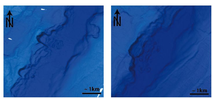
Japan Trench from 36° to 40.3° N. Several smaller submarine landslide (up to several 100’s
m of lateral extent) can be identified along the trench axis in the new bathymetric data set
(Figure 7-1). This features were either not yet present, or not resolved in the lower-resolution
bathymetric dataset acquired before 2011. Sub-bottom acoustic reflection data reveals
striking, up to several meter thick, acoustically transparent bodies interbedded in the
otherwise parallel reflection pattern of the trench fill basins (Figure 7-2). In the southern and
central part of the Japan Trench, such a thick acoustically-homogenous body occurs in the
uppermost portion of the stratigraphic succession and has a lateral extent of several 10’s of
km in along strike direction, suggesting that it may represent huge masses redeposited by
the most recent 2011 earthquake. Older event deposits are imaged in the deeper
stratigraphic succession along the entire studied trench axis. Postcruise mapping and
stratigraphic correlation of identified mass-transport deposits in the parasound data will
reveal the temporal and spatial inventory of major sediment remobilization events along the
Japan Trench and will provide quantitative constraints on volumes and mass fluxes of
material mobilized during each event.
Fig. 7-1: Bathymetric maps acquired with the Kongsberg EM122 mulitbeam system during SO251
in the Japan Trench, showing submarine landslides features on the landward slope into the deep
(> 7km deep) trench axis. This features were either not yet present, or not resolved in the lower-
resolution bathymetric dataset acquired before 2011
27You can also read