Soil Survey and Soil Mapping in the Maltese Islands: the 2003 Position
←
→
Page content transcription
If your browser does not render page correctly, please read the page content below
EUROPEAN SOIL BUREAU ⎯ RESEARCH REPORT NO. 9

Soil Survey and Soil Mapping in the
Maltese Islands: the 2003 Position
J. Sonya Vella
National Soil Unit, Agricultural Services and Rural Development Division, Ministry for
Rural Affairs and the Environment, Marsa, Malta.

Soil Survey                                              characterised by a single ‘soil series’ and 4 of
Unlike other European countries, Malta does not          which are ‘complexes’ or ‘sequences’ in which a
have a tradition of soil survey and monitoring.          number of soil series occur in a complex and often
Until now, Maltese agriculturalists, environmental       unpredictable pattern. The soil series concept used
managers and rural planners have had to rely on          by Lang was largely based on geological criteria,
sporadic and fragmented sources of information in        as was the case in many soil studies at that time.
order to make decisions about the use of the             The individual soil series were defined to
country’s soil resources. It was only recently, in       incorporate the wide range of soil depths and
response to the ever-increasing requirements for         textural classes that could be found on individual
soil information to address environmental,               geological parent materials. The map was based on
agricultural and land planning issues, and as a          detailed field observations within two areas
result of the metamorphosis caused by the process        comprising about 25.9km2 in total. The remaining
of EU accession and alignment to the Acquis              290km2 of the Islands were mapped from aerial
Communitaire, that the first-ever systematic soil        photographs and occasional ‘ground-truth’
survey of the Maltese Islands was initiated by the       observations along traverses. The accompanying
newly established National Soil Unit.                    report describes the soil map units and their broad
                                                         characteristics, gives a classification of the soil
                                                         series, and a set of qualitative descriptions of soil
History                                                  profiles. This soil map has remained in use until
In his report on Agriculture in Malta to the             recently.
Government of Malta, Dawson Shepherd, (1920)
remarks that no exact soil survey had been made of       Although the concept of sustainable use and
the Island, and that he could not find any attempt at    management of the terrestrial environment in
systematic soil analysis. It was in fact D.M. Lang       Malta has only recently started to emerge as a
who in 1960 was responsible for the first detailed       specific goal, Malta is nowadays in a position
study of the soils of Malta and Gozo (Lang, 1960).       whereby it has registered significant progress in
This soil survey was carried out in 1956-57 for the      environment       protection     and     sustainable
then Colonial Office, and finalised in 1960 with         management of land resources. The need was felt
the publication of the soil map of the Maltese           for spatial information in the form of soil physical
Islands at a scale of 1:31,680 (2 inches to 1 mile).     and chemical properties that could be used in
The objective of Lang’s soil survey was to provide       existing European - wide interpretative
basic descriptions of the soils and to map their         environmental models. It was also necessary that
distribution as an aid to agricultural planning. In      any soil information would be compatible with
view of this he mapped differences in chemistry,         current European classification systems.
physics, and biology of the soil, as reflected in soil
colour, texture, and structure, in conjunction with      In the light of these developments, Lang’s soil map
the landscape type.                                      and report were unsatisfactory not only because
                                                         they were based on methodology that has been
In the soil survey carried out by Lang, the soils        superseded, but also because the rapid expansion
were described using Kubiena’s classification            of urban areas since the 1960’s has markedly
system (Table 1).                                        changed the Maltese landscape in and around these
                                                         new urban areas, particularly where topsoil
The resulting soil map shows the distribution of 13      material from the development sites has been used
mapping units, 9 of which are designated as being        to create new terraces or to augment and deepen
                                                         existing ones. In several of the impact assessment

                   Soil Survey and Soil Mapping in the Maltese Islands: the 2003 Position.
                                              Vella, Sonya J.                                          235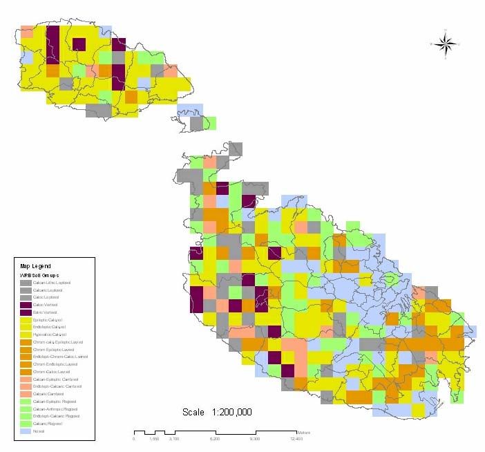
EUROPEAN SOIL BUREAU ⎯ RESEARCH REPORT NO. 9

studies carried out during the process of screening
Maltese legislation in relation to the Acquis, the
                                                         Soil Surveys
importance of assessing the soils of Malta was           The MALSIS project comprises three stages of soil
highlighted repeatedly. The first State of the           survey and soil resources assessment. The first
Environment Report for Malta (Axiaq et al., 1999)        stage consists of a national grid-based inventory of
identified the need to survey the soil resources, and    the soil resources at 1km interval, totaling
to develop a tool for the management of soil             approximately 280 sites in Malta, Gozo and
information as one of the most urgent priorities         Comino (Figure 1). The precise grid survey at
that the government should not only encourage but        these pre-selected geo-referenced target sites was
also fund.                                               initiated in June 2002 and was completed during
                                                         the 14-month period that followed. The soil survey
Soil Information System                                  methodology adopted follows the FAO Guidelines
                                                         for Soil Description (FAO & ISRIC, 1990) with
for Malta                                                minor adaptations to reflect local conditions. A set
                                                         of site and soil characteristics were described from
The Development of a Soil Information System for         shallow pits dug in the field up to a depth of 80cm.
the Maltese Islands: MALSIS LIFE 00                      These characteristics provide information on the
TCY/M/036, has proved to be a major turning              site in terms of agricultural land use, height of
point in establishing a wealth of soil information       terrace, cropping pattern, irrigation, slope, etc., and
and equipping Malta’s public sector with the             soil properties: colour, texture, depth, horizons,
technical expertise to describe, assess, monitor and     structure, penetration, mottles, stones and roots.
manage soils in a sustainable way. This major            This information is recorded on field/soil survey
project is co-funded jointly by the LIFE Third           cards and is used to describe the soils in terms of
Countries programme and the Maltese Ministry for         texture, mineralogy, lithology and landscape. The
Rural Affairs and the Environment. MALSIS is             soil profile descriptions were used to classify the
planned to fulfil both the national requirements for     soils of Malta and Gozo using the World
soils information in Malta, and the broader need to      Reference Base for Soil Resources (WRB),
integrate this data within the information structures    (Figure2).
of the European Soil Bureau (ESB) and wider
international initiatives. The project was launched      According to a first approximation, six soil
in 2002 and is being implemented with the external       reference groups were identified, and Calcisols
technical assistance of soil survey, laboratory and      were recognised to be the dominant soil group in
information system specialists from the National         the Maltese Islands (Table 2). As more results
Soil Resources Institute (NSRI) of Cranfield             become available, it is expected that the qualifiers
University in the UK. The project was completed          of the soil units will be refined on the basis of
in February 2004, however, it will map the               laboratory criteria.
direction for the future work programme of the
Maltese soils office.

     Table 1: Classification of Maltese soils according to the system by Kubiena
 Division          Class          Type          Sub-type            Variety              Locality/Series
                                               (qualified)
A. Sub-
aqueous
              BA. Semi-         VI Rambla 12.Chalk Rambla                            Ghadira Alcol
B. Semi-      terrestrial raw
terrestrial   soils
              BD. Salt soils
              CA. Terrestrial   XXIII      50.Carbonate raw                          Fiddien, San Lawrenz,
              raw soils         Syrosem    soil                                      Nadur, Ramla, part S.B.
              CC. Rendzina-     XXV        60.Humid         (36)Protorendzina        Malta E.
              like soils        Rendzina   Rendzina         Mull rendzina            Malta P.
C.                                         61.Xerorendzina Xerorendzina              San Biagio, Alcol, Tal-
Terrestrial                                                                          Barrani
              CE. Terrae        XXXIII     74. Terra fusca    (47) Earthy terra      Xaghra, Tas-Sigra
              Calxis            Terra                         fusca
                                           75. Terra rossa    (48) Siallitic terra
                                                              rossa

                  Soil Survey and Soil Mapping in the Maltese Islands: the 2003 Position.
236                                          Vella, Sonya J.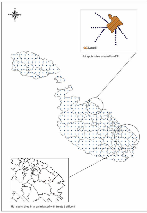
EUROPEAN SOIL BUREAU ⎯ RESEARCH REPORT NO. 9

               Figure 1: Geo-referenced locations of national grid survey

      Table 2: Soil units identified in the national grid survey of Malta and Gozo
Soil Reference Group   Soil Unit                           Number of sites     % of total (272 sites)
Leptosols              Calcari-Lithic Leptosols                           5                         2
                       Calcaric Leptosols                                35                        13
                       Calcic Leptosols                                   1                         0
Vertisols              Calcic Vertisols                                  16                         6
                       Eutric Vertisols                                   4                         1
Calcisols              Epileptic Calcisols                               32                        12
                       Endoleptic Calcisols                              50                        18
                       Hypocalcic Calcisols                              18                         7
Luvisols               Chromi-Calci-Epileptic Luvisols                   13                         5
                       Chromi-Epileptic Luvisols                          2                         1
                       Endolepti-Chromi-Calcic Luvisols                  13                         5
                       Chromi-Endoleptic Luvisols                         9                         3
                       Chromi-Calcic Luvisols                             3                         1
Cambisols              Calcari-Epileptic Cambisols                       13                         5
                       Endolepti-Calcaric Cambisols                       3                         1
                       Calcaric Cambisols                                 3                         1
Regosols               Calcari-Epileptic Regosols                        24                         9
                       Calcaric-Anthropic Regosols                       19                         7
                       Endolepti-Calcaric Regosols                        6                         2
                       Calcaric Regosols                                  3                         1

                Soil Survey and Soil Mapping in the Maltese Islands: the 2003 Position.
                                           Vella, Sonya J.
                                                                                                   237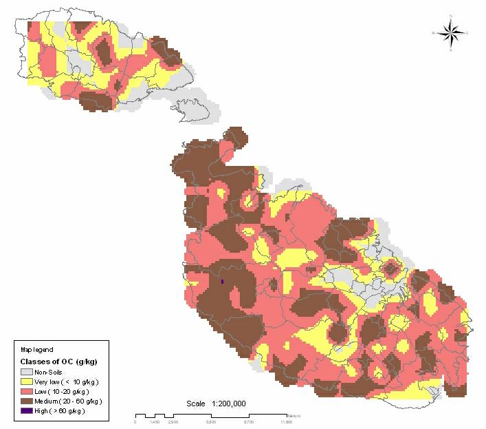
EUROPEAN SOIL BUREAU ⎯ RESEARCH REPORT NO. 9
Figure 2: Classification of Maltese soils according to the WRB system
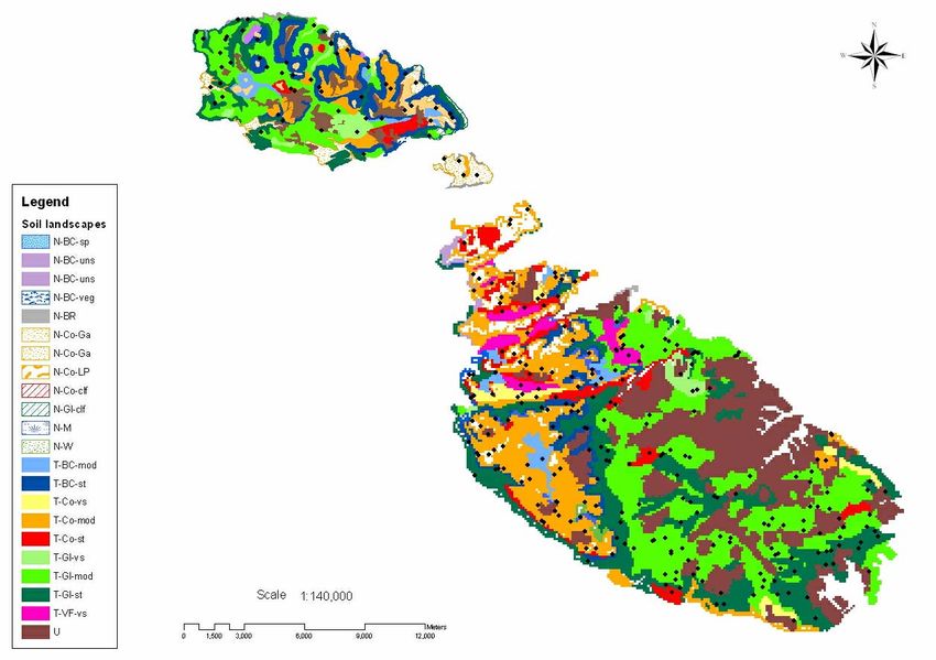
The national grid survey at 1km interval was areas of land, which, whilst containing a range of
preceded by a reconnaissance survey along four soil types, are likely to have a similar and distinct
west east transects across the island. These set of management characteristics.
transects crossed the limestone/calcareous shale
sequence from oldest to youngest rocks and also These so-called soil landscapes contain a range of
incorporated the deep colluvial soils found in some soil types with a defined relationship within the
of the broad ancient valleys on the Island. The landscape (Figure 3). Within these parameters, the
objectives of the reconnaissance survey were to second stage of the MALSIS soil survey
identify the major soil landscapes and to make programme was designed to characterise the small-
reliable judgements on the range and variability of scale variability of important soil properties and
soils within each of these landscapes. This has limitations within these landscapes and to provide
enabled the Maltese Islands to be positioned into a basis for estimating the uncertainty associated
the current version of the Soil Map for Europe with measurements of soil properties at any
derived from the 1:1,000,000 scale (JRC, 2001). specific point. This ‘free soil survey’ has been
ongoing since May 2003, and it is anticipated that
In Malta the spatial pattern of soil types is very it will involve the survey of approximately 320
intricate, both in semi-natural and agricultural sites, 240 in Malta and a further 60 in Gozo
areas, and different soil types often occur within a (Figure 3). It will study the relationships between
single field or within a distance of few metres. In parameters such as soil depth and texture both
order to be able to use the soil inventory for within and between man-made terraces and with
supporting land management and policy inferred landscape position (foot-, mid-, upper-
development, it was necessary to identify broader slopes).
Soil Survey and Soil Mapping in the Maltese Islands: the 2003 Position.
238 Vella, Sonya J.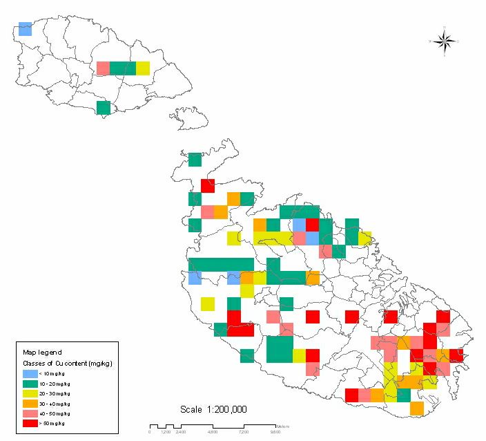
EUROPEAN SOIL BUREAU ⎯ RESEARCH REPORT NO. 9

    Figure 3: Soil landscapes and location of soil variability sites for free survey
                                                                soil samples laboratory values using unique site
                                                                reference and laboratory numbers.
Soil Databases
The soil information system presently in use has                The Maltese soil information system contains soil
been partly developed within the scope of the                   properties datasets derived from site investigations,
MALSIS project. The system was designed to                      limited soil profile descriptions, and laboratory
store, manipulate and output soil attribute data                analysis. Available data consists of site and soil
derived from point observations of fully described              profile characteristics of approximately 350 sites,
and analysed profiles. The information system                   and soil physical and chemical properties of about
incorporates two MS Access databases: Agrilab, a                800 samples (Table 3). The system enables data to
laboratory information management system, and                   be queried, filtered, and mapped using desktop GIS
Malsis, which stores and retrieves soil profile data            (ArcView). Each variable can be expressed in the
(Figure 4).                                                     form of a map or statistical tables, illustrating
                                                                distribution patterns that have never been studied
Another module, MalsisAdmin, facilitates export                 at national scale before. The results (Figure 5)
routines from the two databases and links data                  show that 51% of the agricultural and semi-natural
pertaining to the geo-referenced profiles and the               land in the Maltese Islands has a soil plough layer
                                                                horizon (0-15cm) that contains less than 2% OC
                                                                (3.4% OM).
             Table 3: Soil properties datasets for different soil survey samples
 Soil properties                                    National grid        Local sites               Soil variability
                                                    survey               investigations            survey
                                                                         Maghtab      South east   No analysis have
                                                                                      area         been carried out
                                                    B     H1        H2   B            H2     B     so far
 Bulk density                                             9         9
 Characteristic parameters group 1: pH,             9               9
 inorganic carbon, organic carbon, cation
 exchange capacity, particle size analysis)
 Characteristic parameters group 2: organic         9     9         9
 carbon, cation particle size analysis)
 Salinity/soluble salts (electrical conductivity)   9               9    9            9      9
 Trace and heavy metals (Cu, Zn, Pb, Cr, Ni,        9               9    9            9      9
 Cd, Hg)

                     Soil Survey and Soil Mapping in the Maltese Islands: the 2003 Position.
                                                Vella, Sonya J.
                                                                                                              239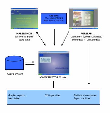
EUROPEAN SOIL BUREAU ⎯ RESEARCH REPORT NO. 9

         Figure 4: Structure of the Maltese soil information system

      Figure 5: Distribution of organic carbon levels in Malta and Gozo
                         (data interpolated by kriging)

          Soil Survey and Soil Mapping in the Maltese Islands: the 2003 Position.
240                                  Vella, Sonya J.
EUROPEAN SOIL BUREAU ⎯ RESEARCH REPORT NO. 9
Although data on the content of trace and heavy
metals in topsoils and subsoils is still incomplete,
Applications of soil data
preliminary findings (Figure 6) show that the The MALSIS soil information system will serve as
highest levels of copper have been found in the a baseline for developing national environmental
south east region of Malta where treated sewage protection strategies and guidelines for better land
effluent is used for irrigation. Most of these levels, and soil management. The primary and derived
however, are below the upper limit value for soils soil properties will be used to assess the soils’
with a pH >7 as stipulated in the Sewage Sludge susceptibility to erosion, the groundwater
Directive, 86/278/EEC (EEC, 1986). The outputs vulnerability to diffuse contamination from
of the national grid survey at 1km interval have not agricultural sources, to assess the land in terms of
shown any extensive contamination by heavy its capability for defined uses, and to facilitate the
metals, but at this stage it is premature to draw any process of land use planning. MALSIS will also
conclusions since results are still being obtained. provide the foundations for a system of nationwide
monitoring of soil quality and soil threats, such as
Soil monitoring required by the EIONET network and the proposed
Directive on Soil Monitoring.
To date, there exists no comprehensive soil-
monitoring programme for the Maltese Islands. Already at this early stage in its generation, the
One of the primary objectives of the MALSIS information derived from the soils properties
project, however, was to achieve the required databases is being used to underpin rural land use
institutional, technical and administrative capacity planning, conservation and development
for soil monitoring through the establishment of programmes such as:
the National Soil Unit. The National Soil Unit is a
newly set up structure within the Ministry for • The elaboration of a Code of Good
Rural Affairs and the Environment with moderate Agricultural Practice and a Nitrate Action
expertise and facilities for soil survey and soil Programme for the Maltese Islands to prevent
laboratory analysis. and combat nitrate pollution of freshwaters
from agricultural sources;
The national grid inventory will serve as a basis for • The production of groundwater vulnerability
selecting reference monitoring sites for future soil maps;
quality monitoring programmes that are specified • The development and implementation of agri-
in accordance to European and national soil environment measures within the Rural
monitoring legislative requirements. It is Development Plan for the Maltese Islands;
anticipated that ongoing monitoring programmes • The development of a strategy for the
will entail detailed survey investigations at 5km promotion of organic farming in the Maltese
intervals and local investigations in Islands;
environmentally sensitive areas. Two such • The development of a national waste
environmentally vulnerable sites have already been management strategy, with emphasis on the
selected and sampled at high density in the local land application of bio-wastes;
sites investigations (stage three of the MALSIS • The assessment of agricultural land suitability
field programme of activities). These sites will be for viticulture.
monitored at a frequency of three years.
The areas that were selected are the south east area Future prospects
of Malta receiving treated sewage effluent from the
In many ways, Malta’s status as a candidate
San Antnin Sewage Treatment Plant and the
country for EU accession has facilitated and
agricultural land surrounding the land-based
accelerated the process of alignment to European
landfill at Maghtab in the north east part of the
standards of environmental protection, particularly
Island (Figure 7). The sampling strategy at
in the protection of water and air. Soils, however,
Maghtab was based on systematic sampling along
are still misplaced within the all-encompassing
five line transects, yielding a total of 50 topsoil
terrestrial concept, and have not yet received their
samples; a judgemental sampling approach was
deserved importance as a distinct resource with
adopted in the south east area, where sampling
unique specific functions.
sites were differentiated according to the types and
rates of agricultural inputs (effluent, bio-wastes,
manures) that can be correlated with the level of
contamination. Another 50 topsoil and subsoil
samples were collected from this area.
Soil Survey and Soil Mapping in the Maltese Islands: the 2003 Position.
Vella, Sonya J.
241EUROPEAN SOIL BUREAU ⎯ RESEARCH REPORT NO. 9
Figure 6: Copper levels in Maltese soils
This is evident, for example, from a review of As a public entity, the National Soil Unit will
existing strategies and policies of the major continue to receive the necessary budget
resource protection entities in Malta that target allocation to progress with its programme of soil
water, air, mineral resources and energy but not survey, laboratory analysis and soil mapping. It
soil. The fact that the only primary legislation is envisaged that the soil properties data derived
that protects soils is not only outdated, but also from the field and laboratory components of the
grossly generic and ineffective, is another MALSIS project will be leased to potential
indicator that soil has not achieved the users. This, together with participation in
importance it merits in a small island with high funding programmes, will generate sufficient
erosion vulnerability and limited potential for revenue for the set-up of on-going monitoring
renewal of the soil resource base. Large-scale programmes aimed at assessing the soils’ quality
public initiatives, such as the MALSIS project, via suitable indicators. In the context of recent
however, are a prognosis that the materialisation endeavours, the future of soil survey, mapping
of the European soil policy into legislation will and monitoring in the Maltese Islands appears to
provide the necessary impetus for soil be more prospective than it has ever been in past
assessment - management - protection driven years.
actions to solidify faster in the coming years.
Soil Survey and Soil Mapping in the Maltese Islands: the 2003 Position.
242 Vella, Sonya J.EUROPEAN SOIL BUREAU ⎯ RESEARCH REPORT NO. 9
Figure 7: Location of survey sites in environmentally sensitive areas
Soil Survey and Soil Mapping in the Maltese Islands: the 2003 Position.
Vella, Sonya J.
243EUROPEAN SOIL BUREAU ⎯ RESEARCH REPORT NO. 9
References Further Reading
Axiaq V. et al. (1999). State of the Environment FAO and ISRIC. (2001). Lecture Notes on the
Report for Malta 1998, Ministry for the Major Soils of the World, World Soil
Environment, Malta. Resources Report 94, FAO, Rome.
Dawson Shepherd J. (1920). Report on Agriculture FAO, ISRIC and IUSS. (1998). WRB: World
in Malta, Government Printing Office, Malta. reference base for soil resources. World Soil
FAO and ISRIC. (1990). Guidelines for soil profile Resources Report 84, FAO, Rome.
description, Third edition (revised), FAO, Ministry for Rural Affairs and the Environment.
Rome. (2003). Code of Good Agricultural Practice
Lang D.M. (1960). Soils of Malta and Gozo, for the Maltese Islands (Draft). Unpublished
Colonial Office Colonial Research Studies report.
report No. 29, HMSO, London. Ministry for Rural Affairs and the Environment.
(2003). MALSIS, A Soil Information System
For The Maltese Islands LIFE
00/TCY/MT/000036 Progress Report, Malta.
Unpublished report.
Ministry of Agriculture and Fisheries. (2000).
MALSIS, A Soil Information System For The
Maltese Islands, Project technical proposal,
Malta. Unpublished report.
Ministry of Agriculture and Fisheries (2003).
MALSIS, A Soil Information System For The
Maltese Islands LIFE 00/TCY/MT/000036
Interim Report, Malta. Unpublished rep
Soil Survey and Soil Mapping in the Maltese Islands: the 2003 Position.
244 Vella, Sonya J.You can also read