Spatial Variations of Sea Level along the Egyptian Mediterranean Coast
←
→
Page content transcription
If your browser does not render page correctly, please read the page content below
Athens Journal of Mediterranean Studies- Volume 6, Issue 2, April 2020 – Pages 141-154
Spatial Variations of Sea Level along the Egyptian
Mediterranean Coast
By Tarek M. El-Geziry* & Mohamed A. Said
This paper is based on hourly sea level data from six tide-gauges distributed
over the Egyptian Mediterranean coast. These data are used to calculate the
tidal characteristics, the spatial variations of the mean sea level, its annual rates
of increase and seasonal variations. Twelve astronomical tidal constituents are
constructed using the T_TIDE package. Along the coast, tides are of
semidiurnal type, and the mean sea level increases from west to east with a
difference of 35 cm between the two extremities. The sea level rate of
increase varied between 1.0 mm/yr (west) and 6.4 mm/yr (east), with an
overall average rate of 3.4 mm/yr. This is higher than the rates of the global
and whole Mediterranean basins, but meanwhile is less than the rate of the
eastern Mediterranean basin. The sea level examines a seasonal trend with
usual lows in spring and highs in summer. The seasonal variations tend to
be mostly affected by the air pressure scheme and wind regime over the coast.
Land subsidence is another factor, which must be considered upon investigation
of sea level variability along the Egyptian Mediterranean coast. However, this
needs to be verified and concluded through more robust actual geological
observations and analyses.
Keywords: Astronomical tides, Egypt, Mean sea level, Mediterranean Sea, Sea
level rise, Seasonal variability.
Introduction
The Egyptian Mediterranean coast stretches over about 1200 km from
Sallum (31°30′13″N; 25°06′54″E) in the west to Rafah (31°17′19″N; 34°14′28″E)
in the east (Figure 1), comprising four different sections on the basis of the
physiographical characteristics. Accordingly, different coastal dynamical features
may be expected for investigation at each of these sections. The most western
section (Section 1) is the northwest Egyptian Mediterranean region, which extends
from Sallum to Alamein and is characterised by the highest elevation above the
mean sea level (MSL) along the entire Egyptian Mediterranean coast (Santamaria
and Farouk 2011). Section 2 presents the middle northern Egyptian Mediterranean
region extending from Alamein to Alexandria, comprising Alexandria Western
Harbour, the main Egyptian port on the Mediterranean. The third section is the
Egyptian Nile Delta region, which extends from Rosetta to Port Said, where the
highest population density inhibits and the main zone of Egypt agriculture
*
Associate Research Professor, Laboratory of Physical Oceanography, Division of Marine
Environment, National Institute of Oceanography and Fisheries (NIOF), Alexandria, Egypt.
Emeritus Professor, Laboratory of Physical Oceanography, Division of Marine Environment,
National Institute of Oceanography and Fisheries (NIOF), Alexandria, Egypt.
https://doi.org/10.30958/ajms.6-2-3 doi=10.30958/ajms.6-2-3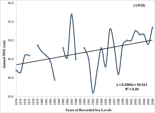
Vol. 6, No. 2                     El-Geziry & Said: Spatial Variations of Sea Level …

activities exist. Lastly, the most eastern section (Section 4) is the north-eastern
Egyptian Mediterranean region, which extends from Port Said to Rafah
comprising the main zone of Egypt industrial and commercial activities,
including the Suez Canal. Along this prolonged coast, five coastal lakes in
connection with the Mediterranean Sea take place. These are Mariut, Edku,
Burullus, Manzalah and Bardawil from east to west, respectively. These Delta
Lakes are key ecosystems that act as a protective zone for inland economic
activities (UNDP 2014). In addition to this coastal lake system, the Egyptian
Mediterranean coast is characterised by the existence of different ports and
harbours, some of which are commercials, e.g., Alexandria, and others serve
mainly fishermen societies, e.g., El-Burullus.

Figure 1. The Egyptian Mediterranean Coast with its Four Geographical Sections
and Locations of the Six Tide Gauges Used in the Present Work

Source: Author.

     The observed sea level variations in the Mediterranean Sea are attributed
to both the meteorological conditions impacting on the internnual and higher
frequencies changes (Gomis et al. 2006) and to the steric parameters influencing
the regional changes (Tsimplis and Josey 2001). The sea level variations in the
eastern Mediterranean basin, as in the whole basin, are driven by changes in the
driving forces of climate and are affected by the anthropogenic factor. Within the
Basin, the sea level decreased between 1960 and 1994 due to the increase in the
atmospheric pressure (Tsimplis and Josey 2001), and the steric heights decreased
as a result of cooling of the upper waters of the eastern Mediterranean (Tsimplis
2002). After 1993, warm air caused sea level in the eastern Mediterranean
basin to rise (Tsimplis 2002). In the Levantine Basin, a SLR (sea level rise) of 10
mm/yr off the Israeli coast during the period 1990-2001 was noticed by Shirman
(2001). The same rate was revealed for the period 1992-2002 (Rosen, 2002).
Larnicol et al. (2002) suggested that the changes observed in the sea level
anomalies during the period 1995-1999 in the Levantine are related to variations in
the deep and intermediate water masses distributions in the whole Eastern basin.
By analysing hydrographic data (temperature and salinity) to investigate the sea

                                       142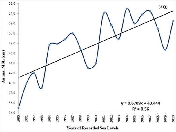
Athens Journal of Mediterranean Studies                                   April 2020

level changes in the Mediterranean Sea, Tsimplis (2002) concluded that most
of the sea level variability in the eastern Mediterranean basin during the last 5
decades is due to steric changes in the upper waters directly linked with cooling.
Vigo et al. (2011) used 16-year altimetery data set (1992-2008) to investigate the
sea level variations in the Mediterranean Sea. Their results revealed that the
amplitudes of the annual cycle vary from 4 to 11 cm, except for a small area of
value around 16 cm at the south-east of Crete corresponding to the Ierapetra
gyre activity. They concluded that the major features of the Mediterranean Sea
circulation are driving the highest seasonal variability in the observed sea level.
The thermosteric contribution in the observed sea level variations is also dominant
in the Levantine Sea (Passaro and Seitz 2012).
     The observed sea level variation off the Egyptian Mediterranean coast results
mainly from the combination of the astronomical tides and surges. Tides, as in
the whole Mediterranean basin, are mainly semidiurnal, with a general tidal range
in the order of a few centimetres (Moursy 1994, Moursy 1998, Tayel 2008,
Hussein et al. 2010, Saad et al. 2011, El-Geziry and Radwan 2012, Said et al.
2012, Radwan and El-Geziry 2013). Surges, on the other hand, have more impact
on the Egyptian Mediterranean coast. They may reach 1.0 m elevation under the
effect of the meteorological factors (El-Geziry and Radwan 2012). The combined
impact of astronomical tides, storm surges and sea level rise (SLR) can severely
affect lives and coastal properties (Douglas 2001). Off the Egyptian Mediterranean
coast, the SLR rate has ranged between 2.0 and 3.0 mm/yr over different periods
(El-Fishawi and Fanos 1989, Frihy 1992, Frihy 2003, Shaker et al. 2011, and
Maiyza and El-Geziry 2012). In addition to the SLR problem, the above-
mentioned four regions along the Egyptian Mediterranean Sea are shown to
examine various environmental stresses that are mainly attributed to anthropogenic
activities: urban, touristic, industrial and agricultural; resulting in pollutants of
land-based sources (UNDP 2011). The environmental problems related to coastal
development, the alteration of the coastline and borders of the wetlands and
watersheds, and the biological threats are all characteristic of these sections
(UNDP 2011, UNDP 2014). Erosion is an additional problem, particularly in the
Delta zone, where engineering and constructive works are constantly required as a
means of protection (Frihy 1992, Frihy and Lotfy 1994, Dasgupta et al. 2009, El-
Sharkawy et al. 2009, El-Raey 2010). The Egyptian Mediterranean coast has been
identified as highly vulnerable to climate change induced SLR. Dasgupta et al.
(2009) ranked Egypt in the top ten most impacted countries (out of 84 developing
coastal countries considered world-wide) for population potentially displaced due
to a 1m sea-level rise. Studies on the vulnerability of Alexandria to SLR revealed
that a 0.3 m increase in the sea level would inundate large parts of the city;
resulting in infrastructure damage, in displacement of over 500000 citizens and
in a loss of about 70000 work opportunities (El-Raey et al. 1999). Alexandria was
also ranked 11th in terms of population exposed to coastal flooding in 2070s (El-
Deberky and Hunicke 2015). Syvitski et al. (2009) identified the Nile and Niger
Deltas as being the most threatened of the African deltas due to land subsidence
and human interference.

                                          143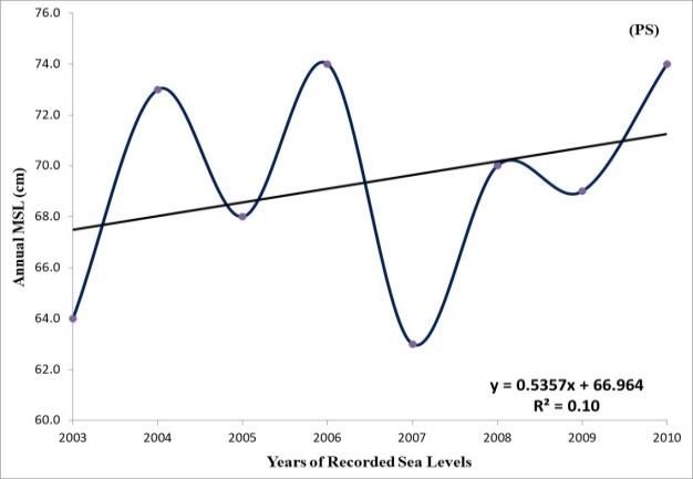
Vol. 6, No. 2                      El-Geziry & Said: Spatial Variations of Sea Level …

     All these factors reflecting the importance of monitoring the sea level
variations along the Egyptian Mediterranean coast motivated this analysis of
sea level, which includes, for the first time, a set of sea level data covering the
whole Egyptian Mediterranean coast. Results from such research are necessary
not only for monitoring sea level but also for preparing a mitigation program
for coastal defence.

Data and Methods of Analysis

     The present work is based on hourly sea level records from six tide gauges
distributed over the Egyptian Mediterranean coast as shown in Figure (1). These
gauges were deployed at Mersa Matrouh (MM), Sidi Abdel-Rahman (SAR),
Alexandria Western Harbour (AWH), Abu-Qir Bay (AQ), Burullus new harbour
(BR) and Port Said (PS) from west to east, respectively. The periods of data are
different for each location (Table 1), with the longest records (30 years) at AWH
and the shortest records (4 years) at MM. The recorded sea level at each location is
referred to the zero level of the instrument.

Table 1. Location Names, Tide Gauge Positions and Periods of Records of Sea
Level Data in the Present Study
                                   Tide Gauge
                                    Position           Period of       % of Missed
Location          Nomination
                                Lat.      Long.        Records            Data
                                (° N)      (° E)
Mersa                                                   4 years
                     MM        31.360     27.183                             0
Matrouh                                               (2003-2006)
Sidi Abdel-                                             5 years
                     SAR       31.070     28.836                             0
Rahman                                                (2012-2016)
Alex.
                                                        33 years
Western             AWH        31.183     29.983                            9.1
                                                      (1974-2006)
Harbour
                                                        21 years
Abu-Qir Bay          AQ        31.325     30.075                             0
                                                      (1990-2010)
                                                         6 years
Burullus             BR        31.582     30.986                             0
                                                      (2003-2008)
                                                         8 years
Port Said            PS        31.256     32.305                             0
                                                      (2003-2010)
Source: Author.

     The sea level records were analysed; in order to get the astronomical tidal
constituents; using the T_TIDE package (Pawlowicz et al. 2002), which works
under the Matlab® environment. T_TIDE is principally based on the concept of
the ability of expressing the tidal amplitudes at any location as the sum of all
the harmonic components:

                                        144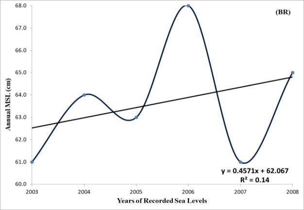
Athens Journal of Mediterranean Studies April 2020
2
(t ) An cos t n (1)
n Tn
Where,
η(t) vertical displacement of the sea surface as a function of time (m)
An amplitude of a harmonic component (m)
Tn period of a harmonic component (s)
φn phase of harmonic component
The T_TIDE package may give up to 68 tidal constituents. A signal-to-noise
power ratio (SNR) is computed based on the square of the ratio of amplitude to
amplitude error, and is used to identify significant constituents. The latter (those
with SNR > 1) are marked with a “*” in the result sheet of the T_TIDE analysis
(Pawlowicz et al. 2002). As tidal amplitudes in the Mediterranean Sea are of a
few centimetres, the present work focuses only on the 12 major tidal components
for all: diurnal, semidiurnal and long period oscillations. These are defined,
according to Kowalik and Luick (2013) in Table 2.
Table 2. The 12 Major Tidal Constituents Generated Using the T_Tide Package
in the Present Study
Long period
Diurnal Constituents Semidiurnal Constituents
Constituents
O1 Principal lunar M2 Pricipal lunar
Mf Lunar fortnightly
diurnal semidiurnal
S2 Principal solar
K1 Lunisolar diurnal Mm Lunar monthly
semidiurnal
P1 Principal solar diurnal N2 Lunar elliptic semidiurnal Sa Solar annual
Q1 Larger lunar elliptic K2 Lunisolar semidiurnal Ssa Solar semiannual
Source: Kowalik and Luick (2013).
The Mean Sea Level (MSL) is often defined as the average value of levels
observed each hour over a period of at least a year, and preferably over about
19 years, to average over the cycles of 18.61 years in the tidal amplitudes and
phases, and to average out weather (Pugh and Woodworth 2014). According to
this definition, the MSL is calculated in the present study based on the hourly sea
level sets. On the basis of the calculated MSL, together with the obtained
astronomical constituents: principal semidiurnal (M2 and S2) and main diurnal
(K1 and O1), the terms describing the main tidal characteristics (Moursy 1994,
1998) along the southern Levantine Basin were calculated. This comprises the
highest high water level (HHWL), the lowest low water level (LLWL), the mean
high water spring (MHWS), the mean low water spring (MLWS), the mean high
water neap (MHWN) and the mean low water neap (MLWN).
Moreover, the type of tides along the Egyptian Mediterranean coast was
determined using the constituent factor (Pugh 2004). According to the value of
the F factor, the type of a tides can be defined as follows: if F ranges between 0
145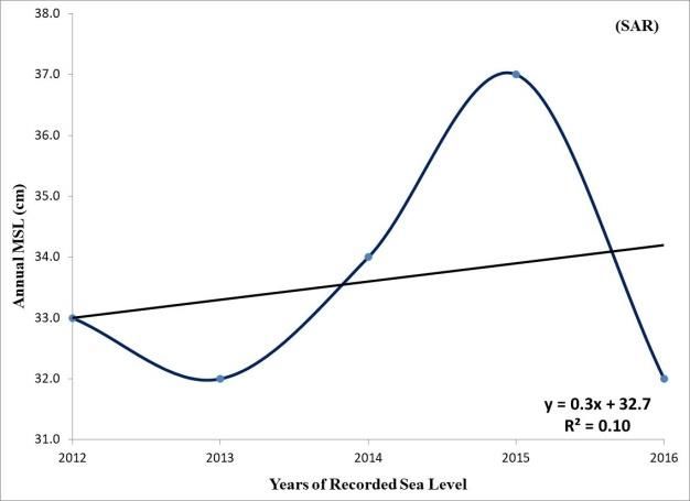
Vol. 6, No. 2                      El-Geziry & Said: Spatial Variations of Sea Level …

and 0.25 then a semidiurnal cycle results; if F ranges between 0.25 and 1.25
then a mixed mainly semidiurnal tide occurs; if F ranges from 1.25 to 3 then a
mixed mainly diurnal tide occurs and finally a diurnal tide results for F values
great than 3 (Pugh 2004).
FF = (HO1 + HK1) / (HM2 + HS2)                                               (2)

Where,

     HO1 is the principal lunar diurnal constituent amplitude;
     HK1 is the luni-solar diurnal constituent amplitude;
     HM2 is the principal lunar semidiurnal constituent amplitude; and
     HS2 is the principal solar semidiurnal constituent amplitude

     Annual and monthly mean levels were calculated for each data set to present
the final results and discussion in the present work.

Results

Tidal Characteristics along the Egyptian Mediterranean Coast

     Table 3 shows the constructed twelve constituents’ amplitudes and phases
at each investigated location in the present study. Despite the weakness of the
observed astronomical tides along the coast, the M2 constituent is still the key
player in the observed variations in the astronomical tides, as in the worldwide
known places of semidiurnal tides. The M2 amplitude has its minimum value (0.6
cm) at SAR and its maximum value in PS (13 cm). Sidi Abdel-Rahman location
has the lowest astronomical tidal elevations among the six investigated locations.
This may be attributed to the deployment location of tide gauge, which is an
enclosed bay with a narrow opening connection to the open sea. The obtained
information on the astronomical elevations was used to calculate the different
water level characteristics along the Egyptian Mediterranean coast. The results
are shown in Table (4). It can be easily deduced that tides along the Egyptian
Mediterranean coast are of mainly semidiurnal type. While the highest HHWL
occurred at PS (87 cm), the lowest LLWL occurred at MM (23 cm). PS and SAR
had the maximum and minimum values, respectively, for both the spring and the
neap water ranges.

The Spatial Pattern of the Mean Sea Level (MSL)

      The spatial variations of the MSL along the Egyptian Mediterranean coast
are presented in Table 4. The MSL increases all the way long from MM to PS,
i.e. from west to east, with a total difference of 35 cm between the two extremities.
AQ and AWH have the same MSL of 48 cm, which is in good agreement with
previously calculated MSL at the two locations over different periods (Saad et
al. 2011, El-Geziry and Radwan 2012, Said et al. 2012, El-Geziry 2013). The

                                        146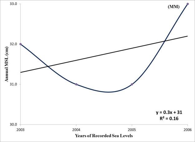
Athens Journal of Mediterranean Studies April 2020
present MSL slope along the Egyptian Mediterranean coast agrees with the
general atmospheric pressure scheme over the Levantine Basin (Tsimplis et al.
2005, Gomis et al. 2008, Oddo et al. 2014).
Spatial Variations of the Annual MSL (Sea Level Rates)
The annual MSL variability and trends at the six tide gauge locations along
the Egyptian Mediterranean coast are shown in Figure 2. Results revealed a
general trend of increase in the annual MSL along the Egyptian Mediterranean
Coast but with different rates. It can be deduced that the regions of sections 3
and 4, comprising the Nile Delta, examine the highest rates of increase being 4.8
mm/yr, 3.8 mm/yr and 6.4 mm/yr at PS, BR and AQ, respectively. On the other
hand, the three other rates of increase are 2.2 mm/yr, 1.0 mm/yr and 2.4 mm/yr
at AWH, SAR and MM, respectively. The average rate of the SLR along the
Egyptian Mediterranean coast is 3.4 mm/yr. This is larger than the global SLR
rate for the 20th century of 1.8±0.5 mm/yr (Church and White 2006, 2011) and for
the whole Mediterranean basin rates, over the same period, of 1.1-1.3 mm/yr
(Tsimplis and Baker 2000). Meanwhile, it is less than the Eastern Mediterranean
rates of 04-20 mm/yr (Cazenave et al. 2001, Rosen 2002, Klein et al. 2004,
Tsimplis et al. 2008, Vigo et al. 2011, Passaro and Seitz 2012).
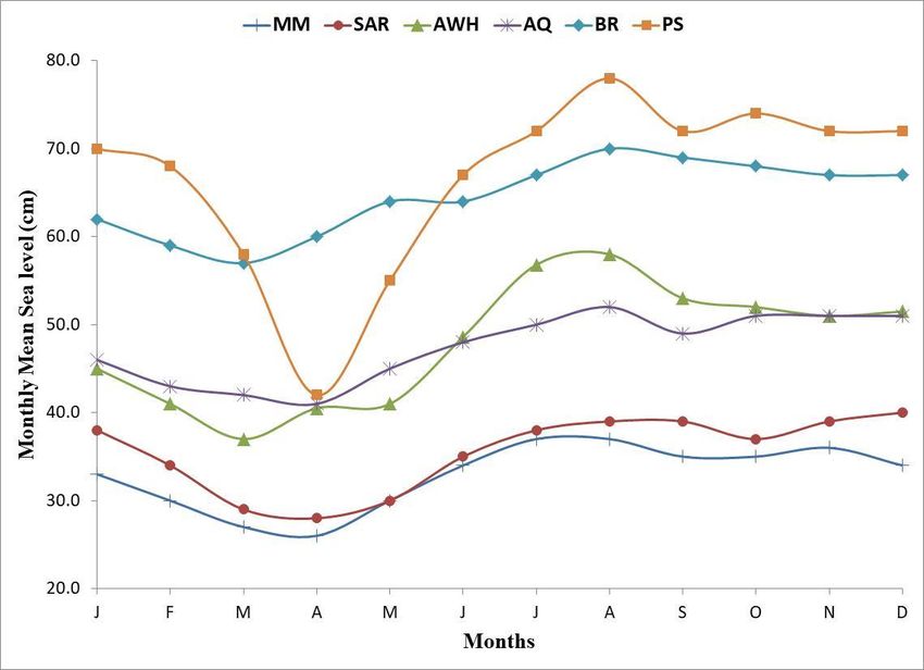
Spatial Variations of the Seasonal Sea Level Variations
The seasonality in the recorded sea level is a major cause of its observed
variability (Torres and Tsimplis 2012). Different coastal regions can be influenced
by different meteorological and oceanographic factors, such as atmospheric
pressure, wind system and the thermohaline steric effects (Gill and Niiler 1973).
Along the Egyptian Mediterranean coast, previous studies in the seasonal
variability of sea level are scarce, although this is important for coastal risk
assessments and mitigation plan initiation to face risks from SLR, storm surges
and floods. Monthly mean variations of sea levels along the Egyptian
Mediterranean coast based on the present data sets are shown in Figure 3. This
shows that the sea level along the Egyptian Mediterranean coast examines a
seasonal trend with usual low values in March and April (spring season) and
higher ones in August (summer season), except at Sidi Abdel-Rahman, where the
maximum mean monthly sea level was in December. November and December
(late autumn/early winter seasons) also examines high mean monthly values.
The seasonal sea level variability along the Egyptian Mediterranean coast can
thus be concluded to be consistent with the atmospheric pressure scheme over
the coast and the wind regime.
147Vol. 6, No. 2 El-Geziry & Said: Spatial Variations of Sea Level …
Table 3. The Twelve Constituents’ Amplitudes and Phases at Each Investigated Tide Gauge Location
Freq. MM SAR AWH AQ BR PS
A Amp. ᶲ (°) Phase A Amp. ᶲ (°) Phase A Amp. ᶲ (°) Phase A Amp. ᶲ (°) Phase A Amp. ᶲ (°) Phase A Amp. ᶲ (°) Phase
(cm) Error Error (cm) Error Error (cm) Error Error (cm) Error Error (cm) Error Error (cm) Error Error
SA 0.000114 4.0 0.80 312 11.46 4.0 0.79 312 12.51 9.0 1.30 334 7.94 5.7 0.80 327 8.48 6.8 0.90 336 7.93 9.8 0.13 344 6.59
SSA 0.000228 2.4 0.80 332 18.71 2.4 0.80 332 19.00 2.5 1.30 318 29.11 2.6 0.80 313 18.58 4.0 0.90 290 13.42 6.5 0.13 305 9.98
MM 0.001512 1.2 0.80 191 73.94 1.2 0.80 191 74.03 0.3 1.30 177 119.85 2.2 0.80 128 17.02 1.8 0.90 12 96.10 1.7 0.13 249 189.92
MF 0.00305 2.8 0.80 118 60.96 2.8 0.79 118 60.94 0.7 1.30 92 6.65 2.0 0.80 110 42.70 2.0 0.90 58 72.29 2.6 0.13 67 46.03
Q1 0.037219 0.8 0.15 12 94.08 0.8 0.15 12 94.10 0.1 0.10 272 44.45 0.6 0.13 13 7.63 0.5 0.13 280 119.42 0.4 0.14 257 150.27
O1 0.038731 0.2 0.15 257 40.24 0.1 0.15 258 42.00 1.0 0.10 326 3.88 0.9 0.13 304 67.67 1.2 0.13 245 51.61 1.2 0.14 259 56.84
P1 0.041553 0.1 0.15 41 72.81 0.1 0.15 41 72.83 0.5 0.10 257 9.09 1.0 0.13 51 70.57 1.1 0.13 20 68.56 1.0 0.14 15 74.28
K1 0.041781 0.4 0.15 34 21.56 0.5 0.15 335 21.60 1.4 0.10 355 3.10 0.3 0.13 344 20.89 3.3 0.13 13 20.30 3.2 0.14 8 21.99
N2 0.078999 1.1 0.13 54 76.30 0.1 0.14 267 75.90 0.7 0.20 20 14.74 0.4 0.07 19 102.50 0.4 0.08 264 108.35 0.3 0.08 261 145.34
M2 0.080511 5.2 0.13 54 9.99 0.6 0.14 281 10.10 5.2 0.20 245 42.10 2.0 0.07 234 12.04 3.7 0.08 326 12.82 13.5 0.08 323 13.84
S2 0.083333 3.2 0.14 322 15.23 0.5 0.14 316 15.03 2.9 0.20 310 3.58 1.3 0.07 307 15.31 2.0 0.08 247 22.45 2.2 0.08 250 20.85
K2 0.083562 0.3 0.14 87 21.91 0.3 0.14 87 22.01 0.8 0.20 333 10.10 0.7 0.07 345 43.16 0.6 0.08 270 63.32 0.6 0.08 273 58.81
Source: Author.
148Athens Journal of Mediterranean Studies April 2020
Table 4. Tidal Characteristics along the Egyptian Mediterranean Coast
MM SAR AWH AQ BR PS
FF 0.10 0.45 0.30 0.37 0.79 0.28
MSL (cm) 32 35 48 48 62 67
HHWL (cm) 41 37 57 53 72 87
LLWL (cm) 23 33 37 43 52 47
MHWS (cm) 40 36 55 51 68 83
MLWS (cm) 24 34 39 45 56 51
Spring range (cm) 16 2 16 6 12 32
MHWN (cm) 34 35 49 49 64 78
MLWN (cm) 30 34 45 47 60 56
Neap range (cm) 4 1 4 2 4 22
Source: Author.
Figure 2. Annual MSL and Trends along the Egyptian Mediterranean Coast
149Vol. 6, No. 2 El-Geziry & Said: Spatial Variations of Sea Level …
Figure 3. Seasonal Variability in the Recorded Sea Levels along the Egyptian
Mediterranean Coast
Source: Author.
Discussion and Conclusion
Sea level data from six tide gauges were used to study four aspects of coastal
sea level: (1) Tidal characteristics, (2) Spatial variations of the MSL, (3) Annual
rates of variations in the MSL and (4) Seasonal variations of sea level, along the
Egyptian Mediterranean coast. The study analysed more extensive data than
previous studies along this coast.
The T_TIDE package was used to produce the twelve major tidal constituents.
Results revealed that astronomical tides along the Egyptian Mediterranean coast
are of mainly semidiurnal type with amplitudes in order of a few centimetres. The
amplitudes of the solar annual constituent (Sa) ranging between 4.0 and 9.8 cm
along the Egyptian Mediterranean Coast are in agreement with Vigo et al. (2011)
who concluded that the amplitudes of the annual cycle in the Mediterranean Sea
vary between 4.0 and 11.00 cm. The M2 constituent is the key player in the
observed astronomical variations, and reaches its maximum in the eastern part of
the coast. Amplitudes and phases of the different tidal constituents in the present
study are in a very good agreement with those previously concluded for AWH
(Moursy 1998, Tayel 2008, Hussein et al. 2010) AQ (El-Geziry 2013) and PS
(Moursy 1998, Tonbol and Shaltout 2013). This is the first study of these
characteristics off El-Burullus, Sidi Abdel-Rahman and Mersa Matrouh. As
such, there was no reference upon which to compare the present work.
The MSL over the different periods of records at each location was calculated.
Results revealed very significant variations in the MSL, with a general slope of
declination from east (PS) to west (MM) along the Egyptian Mediterranean Coast.
150Athens Journal of Mediterranean Studies April 2020
This agrees with the general atmospheric pressure scheme of Lows and Highs
over the Levantine Basin (Tsimplis et al. 2005, Gomis et al. 2008, Oddo et al.
2014).
Analysed tide-gauge data showed that the rate of increase in the sea level
is not evenly distributed along the Egyptian Mediterranean Coast. The overall
average rate of SLR along the Egyptian Mediterranean coast is calculated to be
about 3.4 mm/yr. However, it worth mentioning that the mid-to-east part (AQ,
BR and PS) of the coast examines higher rates than its mid-to-west part (AWH,
SAR and MM). This may be attributed to the pronounced land subsidence
taking place in this eastern region of the Egyptian Mediterranean coast. This
also comes in agreement with the conclusion of Frihy (2003) who assessed the
exposure of the Nile Delta coastal zone to the SLR consequences and identified
four main sections along the Nile Delta Coast as most vulnerable to SLR
including; Burullus and Manzala lakes, western backshore zone of Abu Qir
Bay, Manzala-Port Said area, and Ras El-Barr Beach. His study estimated that
about 30% of the Nile Delta coast would be vulnerable to SLR. Moreover, the
present results open the door for further investigation on the key factors affecting
this part of the Egyptian Mediterranean coast, especially the land subsidence rates.
Recent observations of the subsidence rate at Alexandria using permanent GPS
(Woppelmann and Marcos 2012) showed moderate values of -0.4±0.2 mm/year.
Maiyza and El-Geziry (2012) concluded that the rate of sea level variation off
the Egyptian Mediterranean coast is controlled not only by the oceanographic
factors but also by the land subsidence process, which has much more impact
(⅔) than the former (⅓). Larger rates of subsidence were observed at the eastern
part of the Nile Delta off Port Said, which is subsiding at 5mm/yr and, SLR
and its potential impacts would therefore become more severe than other parts
of the Nile Delta (El-Raey 1997). Comparing projected 21st century SLR and
digital elevation data indicates that the Nile Delta region will not remain safe
from flooding during the current century without effective adaptation measures,
such as shore protection, emission reductions, and integrated coastal-zone
management (Shaltout et al. 2015).
The seasonal variations of the sea level along the Egyptian Mediterranean
coast examine a seasonal trend with low values in spring season and higher
ones in summer. This is in agreement with the conclusions of Moursy (1994).
Further investigation on the oceanographic and meteorological factors, is a must;
in order to get more comprehensive idea about the mechanism of seasonality
and to build robust conclusion on these variations.
So, in conclusion, the Egyptian Mediterranean coast is vulnerable to the sea
level rise. However, its mid-to-east part is much more vulnerable to this rise than
its mid-to-west part. The flooding risk assessment of this region, comprising
the Nile Delta, is a must for designing plans of coastal defence and protection.
More research is needed on the oceanographic and meteorological forces
impacting on the seasonality of variations in the sea level along the Egyptian
Mediterranean coast. Also, the present study strongly recommends more
investigation on the land subsidence rates along the coast in general and off the
Nile Delta in particular.
151Vol. 6, No. 2 El-Geziry & Said: Spatial Variations of Sea Level …
References
Cazenave A, Cabanes C, Dominh K, Mangiarotti S (2001) Recent sea level changes in the
Mediterranean Sea revealed by TOPEX/POSEIDON satellite altimetry. Geophysical
Research Letters 28(8): 1607-1610.
Church JA, White NJ (2006) A 20th century acceleration in global sea-level rise.
Geophysical Research Letters 33(1): L01602.
Church JA, White NJ (2011) Sea-level rise from the late 19th to the early 21st Century.
Surveys in Geophysics 32(4-5): 585–602.
Dasgupta S, Laplante B, Murray S, Wheeler D (2009) Sea-Level Rise and Storm Surges: A
Comparative Analysis of Impacts in Developing Countries. The World Bank, Policy
Research Working Paper, WPS4901, 41p. Available at: http://documents.worldbank.
org/curated/en/657521468157195342/Sea-level-rise-and-storm-surges-a-compara
tive-analysis-of-impacts-in-developing-countries.
Douglas BC (2001) Sea level change in the era of the recording tide gauge. In BC Douglas,
MS Kearney, SP Leatherman (eds) Sea Level Rise, History and Consequences, 37–
64. USA: Academic Press, San Diego, CA.
El-Deberky Y, Hunicke B (2015) Vulnerability of the Nile Delta to recent and future
climate change. In Proceedings of the 36th IAHR World Congress, the Netherlands,
28 June – 3 July, 2015, 1-7.
El-Fishawi NM, Fanos AM (1989) Prediction of sea-level rise by 2100, Nile delta coast.
INQUA, Commission on Quaternary Shorelines, Newsletter 11:43–47.
El-Geziry TM (2013) General Pattern of Sea Level Variation in front of Alexandria
(Egypt) and its Relationship to the Wind Pattern. Egyptian Journal of Aquatic
Research 39(3): 133-139.
El-Geziry T, Radwan A (2012) Sea level analysis of Alexandria, Egypt. Egyptian Journal
of Aquatic Research 38(1): 1-5.
El-Raey M (1997) Vulnerability assessment of the coastal zone of the Nile delta, Egypt, to
the impacts of sea level rise. Ocean & Coastal Management 37(1): 29-40.
El-Raey M (2010) Impacts and Implications of Climate Change for the Coastal Zones of
Egypt. In D Michel, A Pnadya (eds) Coastal zones and climate change, 31-50.
Washington DC, USA: The Henry L. Stimson Center.
El-Raey M, Frihy O, Nasr S, Desouki S, Dewidar K (1999) Vulnerability assessment of
sea level rise over Port Said Governorate, Egypt. Environmental Monitoring and
Assessment 56(2): 113-128.
El-Sharkawy H, Rashed H, Rached I (2009) Climate changes: The impacts of sea level
rise on Egypt. 45th ISOCARP Congress, 11p. Available at: http://www.isocarp.net/
Data/case_studies/1456.pdf.
Frihy OE (1992) Sea-level rise and shoreline retreat of the Nile delta promontories, Egypt.
Natural Hazards 5(1): 65–81.
Frihy OΕ (2003) The Nile delta-Alexandria coast: vulnerability to Sea-level rise,
consequences and adaptation. Mitigation and Adaptation Strategies for Global
Change 8(2): 115–138.
Frihy OE, Lotfy MF (1994) Mineralogy and Textures of Beach Sands in Relation to
Erosion and Accretion along the Rosetta Promontory of the Nile Delta, Egypt.
Journal of Coastal Research 10(3): 588-599.
Gill AE, Niiler PP (1973) The theory of the seasonal variability in the ocean. Deep-sea
Research 20(2): 141-177.
Gomis D, Tsimplis MN, Martin-Miguez B, Ratsimandresy AW, Garcia-Lafuente J, Josey
SA (2006) Mediterranean Sea level and barotropic flow through the Strait of
152Athens Journal of Mediterranean Studies April 2020
Gibraltar for the period 1958–2001 and reconstructed since 1659. Journal of
Geophysical Research 111.Doi:10.1029/2005JC003186 .
Gomis D, Ruiz S, Sotillo MG, Álvarez-Fanjul E, Terradas J (2008) Low frequency
Mediterranean Sea level variability: The contribution of atmospheric pressure and
wind. Global and Planetary Change 63(2-3): 215–229.
Hussein M, Moursy Z, Tayel M (2010) General pattern of Alexandria western harbor sea
level change. JKAU: Marine Science 21(2): 47-61.
Klein M, Lichter M, Zviely D (2004) Recent sea level changes along Israeli and
Mediterranean coasts. Horizons in Geography Special Issues 60-61: 167-176.
Kowalik Z, Luick J (2013) The Oceanography of Tides, 157. USA: University of Alaska.
Larnicol G, Ayoub N. Le Trayon PY (2002) Major changes in Mediterranean Sea level
variability from 7 years of TOPEX/Poseidon and ERS-1/2 data. Journal of Marine
Systems 33-34: 63-89.
Maiyza IA, El-Geziry TM (2012) Long term sea-level variation in the south-eastern
Mediterranean Sea: A new approach of examination. Journal of Operational
Oceanography 5(2): 53-59.
Moursy ZA (1994) Seasonal fluctuation of surge height at Alexanderia, Egypt. National
Institute of Oceanography and Fisheries 20(1): 33-42.
Moursy Z (1998) Characteristics of the tides at the two main harbors of Egypt. JKAU:
Marine Science 9(1): 19-27.
Oddo P, Bonaduce A, Pinardi N, Guarnieri A (2014) Sensitivity of the Mediterranean sea
level to atmospheric pressure and free surface elevation numerical formulation in
NEMO. Geoscientific Model Development 73001-3015 Available at: https://doi.org/
10.5194/gmd-7-3001-2014.
Passaro M, Seitz F (2012) Steric sea level variations in the central-eastern Mediterranean
Sea from Argo observations. Bollettino di Geofisica Teorica ed Applicata 52(1): 131-
147.
Pawlowicz R, Beardsley B, Lentz S (2002) Classical tidal harmonic analysis including
error estimates in MATLAB using T_TIDE. Computers & Geosciences 28(8): 929–
937.
Pugh DT (2004) Changing sea levels: Effects of tides, weather and climate, 280p. UK:
Cambridge University Press.
Pugh D, Woodworth PH (2014) Se-level Science: Understanding tides, surges, tsunamis
and mean sea level, 395. UK: Cambridge University Press.
Radwan A, El-Geziry T (2013) Some statistical characteristics of surges at Alexandria,
Egypt. JKAU: Marine Science 24(2): 31-38.
Rosen DS (2002) Long term remedial measures of sedimentological impact due to coastal
developments on the southeastern Mediterranean coast. In The Changing Coast
(EUROCOAST/EUCC Ed.), 2, 322-331. Available at: https://bit.ly/2kRqqZa.
Saad NN, Moursy ZA, Sharaf El-Din SH (2011) Water heights and weather regimes at
Alexandria Harbor. International Journal Physical Science 6(30): 7035-7043.
Said MA, Moursy ZA, Radwan AA (2012) Climatic change and sea level oscillations off
Alexandria, Egypt. In Proceedings of International Conference on Marine and
Coastal Ecosystems, Albania, 353-359.
Santamaria RM, Farouk M (2011) Study area characterisation. In: Integrated Coastal
Zone Management plan for the coastal areas between Marsa Matruh and El-Sallum,
Egypt, Vo. 1 (Environmental Hydraulics Institute "IH Cantabria" eds), 16-39.
Shaker AA, Saad AA, Al-Naggar D, Faisal H (2011) Absolute sea-level rise estimation at
Alexandria using tide records and GPS observations. FIG Working Week 2011,
Bridging the gap between Cultures, Marrakech, Morocco, 18-22 May 2011, 14p.
Available at: https://bit.ly/2kUWPhF.
153Vol. 6, No. 2 El-Geziry & Said: Spatial Variations of Sea Level …
Shaltout M, Tonbol K, Omstedt A (2015) Sea-level change and projected future flooding
along the Egyptian Mediterranean coast. Oceanologia 57(4): 193-307.
Shirman B (2001) Israel coast sea level changes during 1958-2001. Survey of Israel,
Report No. RD4/1, 17p.
Syvitski JPM, Kettner AJ, Overeem I, Hutton EWH, Hannon MT, Brakenridge GR, Day
J, Vörösmarty C, Saito Y, Giosan L, Nicholls RJ (2009) Sinking deltas due to human
activities. Nature Geoscience, 2: 681-686.
Tayel MF (2008) Using Artificial Intelligence (AI) Techniques for Tidal Level Forecasting
at Alexandria Western Harbor. MSc Thesis, Faculty of Science, University of
Alexandria, Egypt, 114p.
Torres RR, Tsimplis MN (2012) Seasonal sea level cycle in the Caribbean Sea.
Geophysical Research Letters. Doi:10.1029/2012JC008159 .
Tsimplis MN (2002) Sea level in the Mediterranean Sea: The contribution of temperature
and salinity changes. Geophysical Research Letters 29(23): 1-4.
Tsimplis MN, Baker TF (2000) Sea level drop in the Mediterranean Sea: an indicator of
deep water salinity and temperature changes. Geophysical Research Letters 27(12):
1731–1734.
Tsimplis MN, Josey SA (2001) Forcing of the Mediterranean Sea by atmospheric
oscillations over the North Atlantic. Geophysical Research Letters 28(5): 803-806.
Tsimplis MN, Alvarez-Fanjul E, Gomis D, Fenoglio-Marc L, Perez B (2005)
Mediterranean Sea level trends: Atmospheric pressure and wind contribution.
Geophysical Research Letters 32:20.. Doi:10.1029/2005GL023867 .
Tsimplis M, Marcos M, Somot S, Barnier B (2008) Sea level forcing in the Mediterranean
Sea between 1960 and 2000. Global and Planetary Changes 63(4): 325-332.
Tonbol K, Shaltout M, (2013) Tidal and Non- Tidal Sea Level off Port Said, Nile Delta,
Egypt. JKAU: Marine Sciences 24(2): 69-83.
UNDP (2011) Egypt’s National Strategy for Adaptation to Climate Change and Disaster
Risk Reduction. United Nations Development Program, 166. Available at:
http://www.climasouth.eu/docs/Adaptation011%20StrategyEgypt.pdf.
UNDP (2014) Adaptation to Climate Change in the Nile Delta through Integrated Coastal
Zone Management. United Nations Development Program, 73p. Available at:
https://bit.ly/2mkSuoc.
Vigo MI, Sánchez-Realesa JM, Trottini M, Chaoc BF (2011) Mediterranean Sea level
variations: Analysis of the satellite altimetric data, 1992–2008. Journal of
Geodynamics 52(3-4): 271– 278.
Woppelmann G, Marcos M (2012) Coastal sea level rise in southern Europe and the
nonclimate contribution of vertical land motion. Journal Geophysical Research
Letters 117:1). Doi:10.1029/2011JC007469.
154You can also read