Stability assessment of roadbed affected by ground subsidence adjacent to urban railways - NHESS
←
→
Page content transcription
If your browser does not render page correctly, please read the page content below
Nat. Hazards Earth Syst. Sci., 18, 2261–2271, 2018
https://doi.org/10.5194/nhess-18-2261-2018
© Author(s) 2018. This work is distributed under
the Creative Commons Attribution 4.0 License.

Stability assessment of roadbed affected by ground subsidence
adjacent to urban railways
Sang-Soo Jeon1 , Young-Kon Park2 , and Ki-Young Eum3
1 Department  of Civil and Urban Engineering, Inje University, Inje-Ro 197, Gimhae City,
Kyungsangnam-Do 50834, South Korea
2 Smart station research team, Korea Railroad Research Institute, Chuldobakmulgwan-Ro 176,

Uiwang City, Gyeonggi-Do 16105, South Korea
3 Advanced infrastructure research team, Korea Railroad Research Institute, Chuldobakmulgwan-Ro 176,

Uiwang City, Gyeonggi-Do 16105, South Korea

Correspondence: Sang-Soo Jeon (ssj@inje.ac.kr)

Received: 17 November 2017 – Discussion started: 14 December 2017
Revised: 10 June 2018 – Accepted: 19 July 2018 – Published: 24 August 2018

Abstract. In recent years, leakages in aged pipelines for        1   Introduction
water and sewage in urban areas have frequently induced
ground loss, resulting in cavities and ground subsidence,        Urban railways in South Korea have been initiated from the
causing roadbed settlement greater than the allowable value.     first Seoul subway line in 1974 and have been operating in
In this study, FLAC3D , which is a three-dimensional finite-     Seoul and several metropolitan cities. The number of pas-
difference numerical modeling software, is used to perform       sengers using urban railways is increasing and the railway
stability and risk level assessment for the roadbed adjacent     has played a significant role in public transportation for ur-
to urban railways with respect to various groundwater lev-       ban development. Urban railway is defined as a transporta-
els and the geometric characteristics of cavities. Numerical     tion facility and method for smooth transportation in the city
results show that roadbed settlement increases as the diame-     and includes light rail transit and the subway as indicated in
ter (D) of the cavity increases and the distance (d) between     the law of urban railway (Ministry of Land, 2015).
the roadbed and the cavity decreases. The regression anal-          Risk management associated with safety is a fundamen-
yses results show that, as D/d is greater than 0.2 and less      tal focus in railway operations. It has been integrated into
than 0.3, the roadbed is in the status of caution or warn-       global safety management systems of railways (Berrado et
ing. It requires a database of measurement sensors for real-     al., 2010) and developed to allow a rapid risk assessment us-
time monitoring of the roadbed, structures and groundwater       ing a common risk score matrix (Braband, 2012). As roadbed
to prevent disasters in advance. As D/d exceeds 0.35, the        settlements exceed the allowable limits, it may result in track
roadbed settlement substantially increases and the roadbed       irregularity and derailments of trains, causing heavy loss of
is in danger. Since this may result in highly probable traffic   life. Therefore, risk management tools are developed to deal
accidents, train operation should be stopped and the roadbed     with track safety by controlling and reducing the risk of de-
should be reinforced or repaired. The effects of groundwater     railments (Zarembski and Palese, 2006). In this study, meth-
level on roadbed settlement are examined and the analysis        ods to secure the stability of roadbeds have been examined
results indicate that roadbed settlement is highly influenced    using numerical analysis.
by groundwater levels to an extent greater than even the in-        Numerical analyses have been widely used for risk assess-
fluence of the size of the cavity.                               ment. Numerical analyses using three-dimensional geotech-
                                                                 nical codes were carried out to predict the subsidence area
                                                                 and its interaction with buildings (Castellanza et al., 2015),
                                                                 and a three-dimensional groundwater flow model for risk
                                                                 evaluation was developed to be an effective management

Published by Copernicus Publications on behalf of the European Geosciences Union.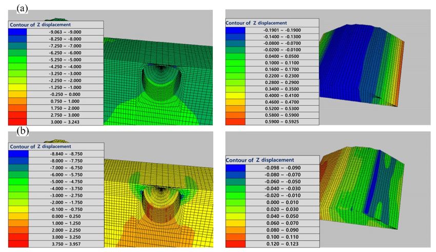
2262                                      S.-S. Jeon et al.: Stability assessment of roadbed affected by ground subsidence

strategy (Ashfaque et al., 2017). The coupling of numeri-        (Fig. 1g) occurred as a 50 m tunnel excavation near the light
cal models and monitoring data contributes to undertaking        rail transit was carried out at Ottawa in Canada (Yonhap
efficient risk reduction policies (Bozzano et al., 2013). Es-    news, 2016). Ground subsidence with a cavity with a depth of
pecially using FLAC, which is a finite-difference numeri-        10 m (Fig. 1h) occurred as subway construction was carried
cal code specialized in the area of geotechnical engineering,    out near Guangzhou in China (Sisa China, 2016). Ground
numerical computations to simulate the influence of rainfall     subsidence with large-scale cavities in urban areas is highly
(Pisani et al., 2010), both acoustic emission (AE) activities    correlated with the undiscerned development of urban areas,
at AE sensor locations of the Kannagawa cavern (Cai et al.,      abuse of groundwater and inappropriate underground con-
2007) and a comprehensive pump test at Sellafield (Hakami,       struction.
2001), showed good agreement with field monitoring results.         A total of 80 % of the ground subsidence occurring from
In this study, FLAC3D , which is a three-dimensional finite-     2010 until the beginning of 2014 in Seoul was induced by
difference numerical code especially specialized in the area     aged pipelines for water and sewage (Oh et al., 2015) since
of geotechnical engineering, is adopted for numerical analy-     48 % and 30 % of sewage pipelines in Seoul were constructed
sis.                                                             more than 30 and 50 years ago, respectively. Aged pipelines
   Research on stability assessment and reinforcement of         for water and sewage could cause numerous cavities in the
railway roadbeds has been actively carried out, but the effect   near future (Segye Ilbo, 2016).
of the cavity adjacent to urban railways on roadbed behavior        As a cavity exists at the center of the railway track in the
has rarely been studied. In recent years, the number of acci-    box structures of urban railways, its influence on box struc-
dents induced by cavities larger than 2 m in diameter has in-    tures and roadbed settlements has been examined to observe
creased, especially in highly populated cities in South Korea.   the effects of cavities adjacent to the roadbeds of urban rail-
Ground subsidence near subways due to self-weight and/or         ways (S. J. Lee et al., 2015). A method to establish a database
surcharge loading was around 60 % (Lee and Kang, 2014).          was proposed to prevent and manage the disasters (Choi et
Changes in groundwater levels (GWLs) may cause increased         al., 2007).
occurrences of ground subsidence because the lowering of            As a cavity exists adjacent to the roadbed, in this study, a
GWLs leads to ground settlement (J. H. Lee et al., 2015).        three-dimensional numerical analysis using FLAC3D is car-
GWL influences both ground settlement and stability of un-       ried out to assess both roadbed stability and risk level with
derground structures. Deep excavation of the ground adjacent     respect to the distance between the center of the roadbed and
to urban railways has a significant influence on the allowable   the center of the cavity, diameter of the cavity, and GWLs.
tensile strength of underground structures (Lee at al., 2017).
If large underground cavities are located at nearby roadbeds,
there is a high potential of ground subsidence.                  2     Numerical analysis
   Ground subsidence (Fig. 1) in South Korea occurred at
nearby urban railways most recently (Kyunghang Times,            The FLAC3D details given in this work are briefly described
2016a). The ground subsidence (Fig. 1a) occurred with a cav-     in the following sections by paraphrasing from those of Itasca
ity with a depth of 5 m, width of 8 m, and length of 80 m        Consulting Group (2002).
near the Seokchon subway station in Seoul. The accident was
induced by inappropriate deep excavation near the subway.        2.1    Theoretical background of FLAC3D
The ground subsidence (Fig. 1b) was caused by the leakage
of a water pipeline with a large-scale cavity with a depth       FLAC3D (Fast Lagrangian Analysis of Continua in 3 Di-
of 21 m, width of 11 m, and length of 12 m near Bakchon          mensions) is a numerical modeling software for advanced
subway station in Incheon (Newshankuk, 2016). The ground         geotechnical analysis of soil, rock, groundwater, and ground
subsidence (Fig. 1c) occurred near Samseongjungang sub-          support in three dimensions. FLAC is used for analysis, test-
way station. Six cavities were found almost simultaneously       ing, and design by geotechnical, civil, and mining engineers
in Seoul (Kyunghang Times, 2016b). A small-scale cavity          (Itasca Consulting Group Inc., 2002). It is designed to ac-
with a depth of 2.2 m (Fig. 1d) occurred near Janghanpyeong      commodate any kind of geotechnical engineering project that
subway station in Seoul, but the cause of this accident has      requires continuum analysis. The mechanics of the medium
not been clarified. The accident was assumed to be caused        are derived from general principles (definition of strain, laws
by inappropriate construction near the subway extension.         of motion), and the use of constitutive equations defining
   Ground subsidence with a cavity with a depth of 3.6 m         the idealized material. The resulting mathematical expres-
(Fig. 1e) occurred as the replacement work of a sewage           sion is a set of partial differential equations, relating mechan-
pipeline was carried out at Texas in the US (Wikitree, 2016).    ical (stress) and kinematic (strain rate, velocity) variables,
Ground subsidence with a cavity with a width of 15 m             which are to be solved for particular geometries and proper-
(Fig. 1f) occurred as tunnel excavation work for a subway        ties, given specific boundary and initial conditions. An im-
extension was carried out at Fukuoka in Japan (Chosun Ilbo,      portant aspect of the model is the inclusion of the equations
2016). Ground subsidence with a cavity with a width of 25 m      of motion, although FLAC3D is primarily concerned with the

Nat. Hazards Earth Syst. Sci., 18, 2261–2271, 2018                        www.nat-hazards-earth-syst-sci.net/18/2261/2018/
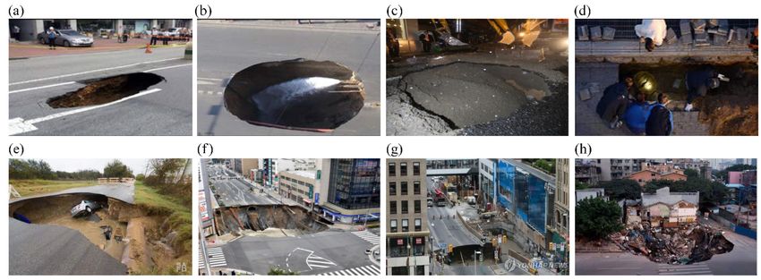
S.-S. Jeon et al.: Stability assessment of roadbed affected by ground subsidence                                                 2263

Figure 1. Ground subsidence near subways: (a) Seokchon subway station, (b) Bakchon subway station, (c) Samseongjungang subway station,
(d) Janghanpyeong subway station in South Korea, (e) Texas in the US, (f) Fukuoka in Japan, (g) Ottawa in Canada and (h) Guangzhou in
China.

                                                                     Figure 3. Configuration of the train load.

                                                                     2.2   Conditions for numerical analysis

                                                                     The Mohr–Coulomb failure model has been used for the
                                                                     analysis (Itasca Consulting Group Inc., 2002, 2016). Since
Figure 2. Configuration of the railway roadbed and cavity.
                                                                     there are various causes and sizes of the cavities of ground
                                                                     subsidence occurring near urban railways, it is very difficult
                                                                     to simulate the process of cavity generation. A circular cav-
state of stress and deformation of the medium near the state         ity below the ground surface has been modeled with respect
of equilibrium. Application of the continuum form of the mo-         to diameters (D) of 4–10 m, which is selected by historical
mentum principle yields Cauchy’s equation of motion:                 events as described in the previous section. Distances of 15–
                                                                     25 m from the cavity to the center of the roadbed and various
σij,j + ρbi = ρ(dvi/dt),                                     (1)
                                                                     GWLs are arbitrarily selected for roadbed settlement influ-
where σ is the symmetric stress tensor, ρ is the mass per unit       enced by the given size of the cavity. The analysis is per-
volume of the medium, [b] is the body force per unit mass,           formed based on the configuration of the analysis (Fig. 2).
and d [v] /dt is the material derivative of the velocity. These      As shown in the figure, roller supports prevent normal trans-
laws govern, in the mathematical model, the motion of an             lations but are capable of tangential translations and/or rota-
elementary volume of the medium from the forces applied to           tions. There is a single linear reaction force either vertically
it. Note that in the case of static equilibrium of the medium,       or horizontally.
the acceleration d [v] /dt is zero, and Eq. (1) reduces to the          An embankment consists of the lower roadbed, upper
partial differential equation of equilibrium:                        roadbed and gravel ballast. The roadbed width at the bot-
                                                                     tom of the ballast is 8 m. The widths of its bottom and top
σij,j + ρbi = 0.                                             (2)
                                                                     are 5.1 and 3.3 m, respectively, and its slope is 1 : 1.8. In situ
                                                                     soil consists of reclaimed soil, silty clay, weathered soil and

www.nat-hazards-earth-syst-sci.net/18/2261/2018/                            Nat. Hazards Earth Syst. Sci., 18, 2261–2271, 2018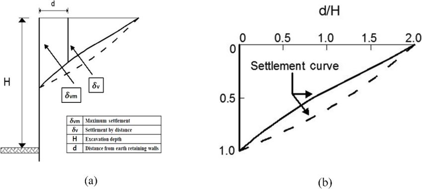
2264                                            S.-S. Jeon et al.: Stability assessment of roadbed affected by ground subsidence

Table 1. Physical properties of soil, rail, PC sleeper and the rail pad.

           Soil type           Height     Unit weight           Elastic     Poisson’s     Cohesion    Friction              Coefficient of     Ko
                                 (m)       (kN m−3 )      modulus (kPa)      ratio (υ)       (kPa)   angle (◦ )      permeability (cm s−1 )
   Soil    Ballast stone           0.3           19.0           133 900          0.30            –            35                         –    0.43
           Upper roadbed           1.5           18.0            81 600          0.20          3.0            32                         –    0.47
           Lower roadbed           1.5           18.0            51 000          0.30         10.0            30                         –    0.50
           Land fill               1.5           17.0            30 000          0.35          5.0            24                1.0 × 10⁻³    0.59
           Silty clay              1.5           17.0            20 000          0.35          5.0            25                5.0 × 10⁻⁴    0.58
           Weathered soil I       15.0           19.0            75 000          0.33         10.0            30                1.0 × 10⁻⁴    0.50
           Weathered soil II      15.0           19.0            70 000          0.33         10.0            33                1.0 × 10⁻⁴    0.46
           Weathered rock          7.0           20.0           110 000          0.31         60.0            42                1.0 × 10⁻⁵    0.33

                                              Area      Unit weight         Elastic             Moment of inertia
                                            (mm2 )       (kN m−3 )    modulus (kPa)                 (m4 )
                                                                                                     IXX                 IY Y
                         KS60 rail           7,741            77.5     21 000 × 104        30 820 × 10−9      5120 × 10−9
                                           Length            Width             Height                      Interval between
                                              (m)             (m)                (m)                            sleepers (m)
                         PC sleeper           2.45            0.28               0.20                                    0.58
                                         Thickness                         Unit weight         Vertical spring coefficient
                                             (mm)                           (kN m−3 )                    of rail pad (kPa)
                         Rail pad                5                               11.5                              15.3 × 10⁷

Figure 4. Settlement of clay and sand backfill with respect to the distance from earth retaining walls: (a) settlement of backfill and (b) pre-
diction of settlement.

weathered rock. Its physical properties listed in Table 1 are                 numerical analysis. Its properties are listed in Table 1. The
obtained from lab experiments of soil sampled at a construc-                  beam element is used for the rail and rail pad.
tion site.                                                                       An axial load of the urban railway train (16 t) is applied
   KS60 rail and prestressed concrete (PC) sleeper com-                       for the numerical analysis. The effective loading is estimated
monly used in gravel ballast have been used for the numerical                 by multiplying 1.2 with half of the axial load considering a
analysis. A rail pad, which is widely used to minimize vibra-                 wheel loading increment of 20 % and a marginal safety of de-
tion and impact loading during train operation, is made of                    ficiency of the cant. Dynamic loading to reflect the dynamic
ethylene vinyl acetate (EVA). However, in this study, a ther-                 impact ratio (Fig. 3) was estimated by multiplying 1.2 with
moplastic polyurethane (TPU) rail pad, which is more eco-                     the effective loading (Ministry of Land, 2015).
nomical and has higher tensile strength has been used for the

Nat. Hazards Earth Syst. Sci., 18, 2261–2271, 2018                                       www.nat-hazards-earth-syst-sci.net/18/2261/2018/
S.-S. Jeon et al.: Stability assessment of roadbed affected by ground subsidence 2265
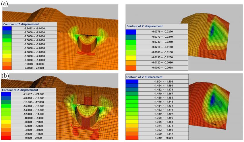
Figure 5. Vertical displacement contour of the roadbed at a distance of 20 m between the center of the roadbed and the center of the
cavity = 20 m with respect to diameter of the cavity: (a) diameter = 8 m and (b) diameter = 10 m.
In general, an allowable settlement of 10 mm has been rec- tion depth near the wall and a settlement linearly decreases
ommended in South Korea. The vibratory loading induces as d increases. Little settlement occurs as d = 2H . Empirical
a loose state in the gravel, and frequent repairs of ballasts correlations of settlement with d proposed by Bowels (1998)
are required. Therefore, an allowable settlement of 2.5 mm and Peck (1969) were similar to the one proposed by Clough
is used to attain additional marginal safety considering the and O’Rourke (1990). Bowels (1998) suggested that the set-
compressive displacement of both the rail pad and ballasts, tlements tend to average about 0.13 %–0.18 % H . The mag-
settlement of rail, ride quality, and both water inflow and nitude of settlements is influenced by the ground stiffness,
cracks in the pavement surface of roadbeds (Jeon, 2014). the wall stiffness and support spacing. In this study, although
ground is not fully excavated and also there are no wall sys-
tems, the settlement resulting from stress release in ground
3 Results and discussion similarly occurs.
The contours of ground settlement are presented for how
3.1 Roadbed settlement the roadbed (Fig. 5) is influenced by a cavity adjacent to the
urban railways. The contours of ground settlement are pre-
The ground settlement in the backfill area due to the exca- sented for cavities with diameters of 8 and 10 m at a distance
vation work has been estimated (Kojima et al., 2005; Kung of 20 m between the center of the roadbed and the center of
et al., 2009; Ou et al., 2013) and its effect on responses of the cavity. As shown in the figures, ground settlement in-
adjacent buildings has been investigated (Lin et al., 2017; creases as the diameter of the cavity increases. As a cavity
Sabzi and Fakher, 2015; Schuster et al., 2009). Clough and is generated on the right side of the roadbed, the right end of
O’Rourke (1990) have proposed the method to estimate set- the roadbed is significantly settled down.
tlement in clay and sandy soils for in situ wall systems using The analysis results (Fig. 6) are presented for cavities with
field measurement data and finite element analysis (Fig. 4). diameters of 4–10 m. As the variation from 15 to 20 m in the
H , d, δvm and δ represent an excavation depth, a distance distances between the center of the roadbed and the center
from the wall, the maximum settlement and a settlement with of the cavity is applied to the 10 m cavity, roadbed settle-
respect to the distance, respectively. The settlements tend to ments are calculated with respect to various diameters of the
average about 0.15 % H . δvm occurs in the middle of excava- cavity. The cavity with a diameter of 10 m at a distance of
www.nat-hazards-earth-syst-sci.net/18/2261/2018/ Nat. Hazards Earth Syst. Sci., 18, 2261–2271, 20182266 S.-S. Jeon et al.: Stability assessment of roadbed affected by ground subsidence
Figure 6. Roadbed settlement with respect to the distance between roadbed and cavity: (a) diameter = 4 m, (b) diameter = 6 m, (c) diame-
ter = 8 m and (d) diameter = 10 m.
20 m has little influence on the roadbed. However, as the di-
ameter of the cavity at the same distance exceeds 10 m, the
roadbed settlement exceeds the allowable value. As cavities
with diameters of 8 and 6 m are generated, at distances less
than 18 and 15 m, where d is close to or less than 2H (2D),
the roadbed settlement may exceed the allowable settlement,
resulting in an accident.
Roadbed settlement increases as the diameter (D) of the
cavity increases and the distance (d) between the roadbed
and the cavity decreases. Therefore, in this study, the roadbed
settlement is examined with respect to D normalized by d
(Fig. 7). The regression analyses results show medium to
high correlations of r 2 = 0.72. As D/d is greater than 0.2
and less than 0.3, the roadbed settlement is approximately
5 mm. A database of measurement sensors should be estab-
lished for real-time monitoring of the roadbed, structures and
groundwater to prevent disasters in advance. As D/d exceeds
Figure 7. Regression analysis of roadbed settlements with respect
0.35, the roadbed settlement substantially increases and is to the diameter of the cavity and distance between the roadbed and
greater than 10 mm. Since it may result in highly probable the cavity.
traffic accident, train operation should be stopped and the
roadbed should be reinforced or repaired.
Nat. Hazards Earth Syst. Sci., 18, 2261–2271, 2018 www.nat-hazards-earth-syst-sci.net/18/2261/2018/S.-S. Jeon et al.: Stability assessment of roadbed affected by ground subsidence 2267
Figure 8. Vertical displacement contours of the roadbed for a cavity with a diameter of 8 m, at the roadbed-to-cavity distance of 25 m:
(a) GWL: ground surface and (b) GWL = −8 m.
The risk level has been estimated by the occurrence of GWL on the ground surface and 20 m below it (Fig. 8a and
roadbed settlements. The risk level has been defined by the b). The settlement of the roadbed is highly subject to GWLs.
value of the roadbed settlements relative to the allowable set- The roadbed settlement (Fig. 9) is highly influenced by
tlement. The risk level is defined as safe (not problematic for groundwater. Ground settlement for 4 and 6 m diameter cav-
both ride quality and track repair), caution (not problematic ities located at a distance of 20 m from the roadbed (Fig. 9a
for track repair), warning (between caution and danger) and and b) satisfies the allowable value for GWL = −4 and
danger (highly probable traffic accident) as a settlement is −12 m, respectively. The ground settlement for 8 and 10 m
equal to or less than 2.5 mm, greater than 2.5 mm and equal diameter cavities located at a distance of 25 m from the cen-
to or less than 4 mm, greater than 4 mm and equal to or less ter of the roadbed (Fig. 9c and d) has substantially decreased
than 9 mm, and greater than 9 mm, respectively. as the GWL is 8 and 15 m below the ground surface, respec-
tively, and satisfies the allowable value as its level is 18 and
3.2 Effects of groundwater level 22 m below the ground surface, respectively. This indicates
that a roadbed settlement is highly influenced by GWLs to
In this study, the effects of GWL on the roadbed settlement an extent greater than even the influence of the size of the
are examined and the GWL is lowered until the allowable cavity.
settlement value of the roadbed is satisfied. The maximum
distance between the roadbed and the cavity for the analysis 3.3 Risk level assessment of roadbed
is determined as the maximum value for the satisfied allow-
able settlement with no groundwater conditions. A stability Roadbed settlements induced by the cavity near urban rail-
assessment of the roadbed has been carried out at the distance ways have been estimated with respect to the GWL, distance
of 20 m for both 4 and 6 m diameter cavities and at 25 m for between the roadbed and cavity, and size of the cavity. As
both the 8 and 10 m diameter cavities. listed in Table 2, the roadbed settlement increases as the size
The contours of ground settlement (Fig. 8) are presented of the cavity increases and the cavity is located close to the
to examine the GWL effects in the case of the 8 m diame- roadbed. As listed in Table 2, the roadbed settlement for
ter cavity located at a distance of 25 m from the roadbed to no groundwater conditions is less than the allowable value,
cavity. The contours of ground settlement are presented with whereas it is in extreme danger when groundwater is present.
www.nat-hazards-earth-syst-sci.net/18/2261/2018/ Nat. Hazards Earth Syst. Sci., 18, 2261–2271, 20182268 S.-S. Jeon et al.: Stability assessment of roadbed affected by ground subsidence
Figure 9. Roadbed settlement with respect to the groundwater level: (a) diameter of the cavity = 4 m and distance of roadbed from the
center of the cavity = 20 m, (b) diameter of the cavity = 6 m and distance of the roadbed from the center of cavity = 20 m, (c) diameter of
the cavity = 8 m and distance of the roadbed from the center of cavity = 25 m, and (d) diameter of the cavity = 10 m and the distance of the
roadbed from the center of the cavity = 25 m.
When it is in the status of danger, train operation should be ious GWLs and sizes of cavities. The analysis results show
stopped and the roadbed should be reinforced or repaired. that roadbed settlement increases as the diameter (D) of the
When it is in the status of caution or warning, a database cavity increases and the distance (d) between the roadbed
of measurement sensors for urban railways should be estab- and the cavity decreases. The regression analysis results
lished for real-time monitoring of the roadbed, structures and show that, as D/d is greater than 0.2 and less than 0.3, a
groundwater for disaster prevention. database of measurement sensors should be established for
real-time monitoring of the roadbed, structures and ground-
water to prevent disasters in advance. As D/d exceeds 0.35,
4 Conclusions the roadbed settlement, which substantially increases and is
in the status of danger, may result in highly probable traffic
The number of occurrences of ground subsidence induced by
accidents. Therefore, train operation should be stopped and
a leakage of aged pipelines for water and sewage in urban ar-
the roadbed should be reinforced or repaired. The effects of
eas resulting in various sizes of cavity near the urban railway
GWL on the roadbed settlement are examined at the distance
in Seoul has been found to increase and it may cause roadbed
of 20 m for both 4 and 6 m diameter cavities and at 25 m for
settlement to exceed the allowable value. A large-scale cavity
both 8 and 10 m diameter cavities. Ground settlement for 4
is rarely found, but if it is close to the roadbed, the roadbed
and 6 m diameter cavities located at a distance of 20 m from
is highly influenced by the cavity and may cause train derail-
the roadbed satisfies the allowable value for GWL = −4 and
ment.
−12 m, respectively. The ground settlement for 8 and 10 m
In this study, numerical analyses are carried out to esti-
diameter cavities located at a distance of 25 m from the cen-
mate roadbed stability and its risk level associated with var-
Nat. Hazards Earth Syst. Sci., 18, 2261–2271, 2018 www.nat-hazards-earth-syst-sci.net/18/2261/2018/307 groundwater level, distance between the roadbed and cavity, and size of the cavity. As listed in Table 2, the
308 roadbed settlement increases as the size of the cavity increases and the cavity is located close to the roadbed. As
309 listed in Table 2, the roadbed settlement for no groundwater condition is less than the allowable value, whereas it is
310 in extreme danger when groundwater is present. When it is in the status of danger, train operation should be
S.-S.
311 Jeonstopped
et al.: and
Stability assessment
the roadbed ofreinforced
should be roadbedoraffected
repaired.by ground
When it is insubsidence
the status of caution or warning, a database 2269
312 of measurement sensors for urban railways should be established for real-time monitoring of the roadbed,
313 2. Risk
Table structures and
level of thegroundwater forrespect
roadbed with disastertoprevention.
the diameter of the cavity and the distance between the roadbed and the cavity for the
314
groundwater condition. Safety (settlement ≤ 2.5 mm), caution (2.5 mm < settlement ≤ 4.0 mm), warning (4.0 mm < settlement ≤ 9.0 mm)
and danger (9.0 mm < settlement).
ter of the roadbed has substantially decreased as GWL is 8 Edited by: Paolo Tarolli
and 15 m below the ground surface, respectively, and satis- Reviewed by: two anonymous referees
fies the allowable value as its level is 18 and 22 m below the
ground
324 surface, respectively.
urban areas This
resulting in indicates
various sizes ofthat roadbed
cavity set-urban railway in Seoul City has been found to increase and
near the
325
tlement isithighly influenced
may cause by GWLs
the roadbed to toanexceed
settlement extentthegreater
allowable value. A large-scale cavity is rarely found, but if it is
References
326 even close
than to the roadbed,
the influence of thethe roadbed
size of theiscavity.
highly influenced by the cavity and may cause train derailment.
327 In this study, numerical analyses are carried out to estimate roadbed stability and its risk level associated with
Ashfaque, K., Kladias, M., Sager, S., and Schlekat, T.: Numerical
328 various groundwater levels, sizes of cavities. The analyses results show that roadbed settlement increases as the
modeling to evaluate hydrological dynamics and risk assessment
329 diameter (D) of the cavity increases and the distance (d) between the roadbed and the cavity decreases. The
Data availability. The data are available from the authors upon re- of bottom ash ponds at a former coal-fired electric power plant,
330
quest.
regression analyses results show that, as D/d is greater than 0.2 and less than 0.3, a database of measurement
World of coal ash conference, 8–11 May 2017, Lexington, KY,
331 sensors should be established for real-time monitoring of the roadbed, structures and groundwater to prevent
USA, 1–13, 2017.
332 disasters in advance. As D/d exceeds 0.35, the roadbed settlement, which substantially increases and is in the status
Berrado, A., El-Loursi, E., Cherkaoui, A., and Khaddour, M.:
Competing interests. The authors declare that they have no conflict10 A Framework for Risk Management in Railway Sector: Ap-
of interest. plication to Road-Rail Level Crossings, Open transporta-
tion Journal, Bentham Open, 19 pp., available at: https://
hal.archives-ouvertes.fr/hal-00542424 (last access: June 2017),
Special issue statement. This article is part of the special issue 2010.
“Landslide–road network interactions”. It is not associated with a Bowles, J. E.: Foundation analysis and design, 4th edn., McGraw-
conference. hill, New York, USA, 658–667, 1998.
Bozzano, F., Cipriani, I., Esposito, C., Martino, S., Mazzanti, P.,
Prestininzi, A., Rocca, A., and Mugnozza, G. S.: Landslide risk
reduction by coupling monitoring and numerical modeling, In-
Acknowledgements. This work was supported by the 2017 INJE
ternational conference Vajont 1963–2013. Thoughts and analy-
University research grant.
ses after 50 years since the catastrophic landslide, 8–10 October
2013, Padua, Italy, 315–322, 2013.
www.nat-hazards-earth-syst-sci.net/18/2261/2018/ Nat. Hazards Earth Syst. Sci., 18, 2261–2271, 20182270 S.-S. Jeon et al.: Stability assessment of roadbed affected by ground subsidence Braband, J.: Rapid Risk Assessment of Technical Systems in Rail- engineering, The institute of electronics and information engi- way Automation, Proc. Of the Australian System Safety Confer- neering, 7–9 July 2015, Yesan, South Korea, 1735–1737, 2015. ence, 23–25 May 2012, Brisbane, Australia, 21–26, 2012. Lee, K. Y. and Kang, S. J.: Causes and Countermeasures of Sinkhole Cai, M., Kaiser, P. K., Morioka H., Minami, M., Maejima, T., Swallowed the City, Issue and Analysis, 156, 1–23, 2014. Tasaka, Y., and Kurose, H.: FLAC/PFC coupled numerical simu- Lee, S. J., Lee, J. W., Jung, Y. N., and Cho, H. J.: Sensitivity Analy- lation of AE in large-scale underground excavations, Int. J. Rock sis of the Deformations caused by Cavity Generation in Subway Mech. Min., 44, 550–564, 2007. Trackbed Foundation using the FEA, Proceedings of Korean So- Castellanza, R., Orlandi, G. M., Prisco, C. di, Frigerio, G., Flessati, ciety for Railway Fall Conference, 22–24 October 2015, Yeosu, L., Fernandez Merodo J. A., Agliardi, F., Grisi, S., and Crosta, G. South Korea, 1480–1485, 2015. B.: 3D numerical analyses for the quantitative risk assessment Lin, H. D., Liao, H. C., Lin, K. J., Hsieh, Y. M., and Chen, C. C.: of subsidence and water flood due to the partial collapse of an Excavation-induced Ground Settlements and responses of adja- abandoned gypsum mine, IOP C. Ser. Earth Env., 26, 1–7, 2015. cent building at various positions using 3D decoupled analysis Choi, C. Y., Kim, D. S., Lee, J. W., and Shin, M. H.: Development method, Proceedings of the 19th International Conference on of Database System for Management of Roadbed Settlement in Soil Mechanics and Geotechnical Engineering, 17–22 Septem- High Speed Railway, Proceedings of Korean Society for Railway ber 2017, Seoul, South Korea, 1721–1724, 2017. Fall Conference, 8–9 November 2007, Uiwang, South Korea , Ministry of Land: Infrastructure and Transport, Seoul, Korea, avail- 496–500, 2007. able at: http://www.molit.go.kr/portal.do, last access: 15 June Chosun Ilbo: Excavations for 15-m diameter large-scale sinkhole 2015. Fukuoka in Japan, available at: http://news.chosun.com/site/data/ Newshankuk: Asphalt road in swallowed by sinkhole brief moment, htmldir/2016/11/08/2016110801318.html, last access: Decem- available at: http://www.newshankuk.com/news/content.asp?fs= ber 2016. 12&ss=57&news_idx=201202201707081291, last access: De- Clough, G. W. and O’Rourke, T. D.: Construction Induced Move- cember 2016. ments of In situ Walls, Geotech. Sp., 25, 439–470, 1990. Oh, D. W., Kong, S. M., Lee, D. Y., Yoo, Y. S., and Lee, Y. J.: Effects Hakami, H.: Rock Characterisation facility (RCF) shaft sinking – of Reinforced Pseudo-Plastic Backfill on the Behavior of Ground numerical computations using FLAC, Int. J. Rock Mech. Min., around Cavity Developed due to Sewer Leakage, Journal of the 38, 59-65, 2001. Korean Geoenvironmental Society, 16, 13–22, 2015. Itasca Consulting Group, Inc.: FLAC3D Manual-Theory and Back- Ou, C.-Y., Teng, F.-C., Hsieh, P.-G., and Chien, S.-C.: Mechanism ground, Minnesota, USA, 2002. of Settlement Influence Zone due to Deep Excavation in Soft Itasca Consulting Group, Inc.: Outline of FLAC3D , available at: Clay, Proceedings of the 18th International Conference on Soil https://www.itascacg.com/software/flac3d#slideshow-6, last ac- Mechanics and Geotechnical Engineering, 2–6 September 2013, cess: June 2016. Paris, France, 2063–2066, 2013. Jeon, S.-S.: Roadbed behavior subjected to tilting-train loading at Peck, R. B.: Deep Excavations and Tunneling in Soft Ground, Pro- rail joint and continuous welded rail, J. Cent. South Univ., 21, ceedings of 7th International Conference on Soil Mechanics and 2962–2969, 2014. Foundation Engineering, 25–29 August 1969, Mexico City, Mex- Kojima, K., Ohta, H., Iizuka, A., and Tateyama, M.: A Simple Eval- ico, 225–290, 1969. uation Method of Adjacent Ground Settlement due to Excava- Pisani, G., Castelli, M., and Scavia, C.: Hydrogeological model tion Work, Proceedings of the 5th International Conference of and hydraulic behaviour of a large landslide in the Italian TC28 of the ISSMGE, 15–17 June 2005, Balkema, Rotterdam, Western Alps, Nat. Hazards Earth Syst. Sci., 10, 2391–2406, the Netherlands, 719–723, 2005. https://doi.org/10.5194/nhess-10-2391-2010, 2010. Kung, G. T., Ou, C. Y., and Juang, C. H.: Modelling Small-strain Sabzi, Z. and Fakher, A.: The Performance of Buildings adjacent to Behaviour of Taipei Clays for Finite Element Analysis of Braced Excavation Supported by Inclined Struts, J. Civ. Eng., 13, 1–13, Excavations, Comput. Geotech., 36, 304–319, 2009. 2015. Kyunghang Times: Additional findings of ground sub- Schuster, M., Kung, G. T. C., Juang, C. H., and Hashash, Y. M. A.: sidence in Seckchon subway in Seoul, available at: Simplified Model for Evaluating Damage Potential of Buildings http://news.khan.co.kr/kh_news/khan_art_view.html?artid= Adjacent to a Braced Excavation, J. Geotech. Geoenviron., 135, 201408211343301&code=940100, last access: December 1823–1835, 2009. 2016a. Segye Ilbo: Half of sewage pipelines left for thirty years without Kyunghang Times: “6; sinkholes concurrence at the same maintenance leads to disaster of sinkhole, available at: http:// time” nearby Sanseongjungang of subway 9th line station, www.segye.com/newsView/20150322002265, last access: 3 De- http://sports.khan.co.kr/culture/sk_index.html?cat=view&art_ cember 2016. id=201504031002483&sec_id=562901&pt=nv, last access: Shin, E. C. and Roh, J. M.: Estimation of RPS Method Using 3- December 2016b. Dimensional Numerical Analysis, Journal of the Korean Society Lee, H. J., Lee, Y. T., Choi, I. W., Lee, M. S., and Lee, T. G.: Inves- for Railway, 9, 174–179, 2006. tigation of Settlement of Concrete Track on High-Speed Railway Sisa China: Three of buildings one subsidence at Guangzhou Due to Groundwater Variation, Journal of the Korean Society for in China, available at: http://sscn.kr/news/view.html?section= Railway, 20, 248–256, 2017. 1&category=5&no=3561, last access: December 2016. Lee, J. H., Lee, H. S., and Lee, I. H.: IoT-based Convergence Tech- Wikitree: “Giant sinkhole” resulting in rushed car and depth of sher- nology for Urban Underground Sinkhole Prediction, in: 2015 iff, available at: http://www.wikitree.co.kr/main/news_view.php? Summer meeting of The institute of electronics and information id=284413, last access: December 2016. Nat. Hazards Earth Syst. Sci., 18, 2261–2271, 2018 www.nat-hazards-earth-syst-sci.net/18/2261/2018/
S.-S. Jeon et al.: Stability assessment of roadbed affected by ground subsidence                                           2271

Yonhap news: Large-scale at Ottawa in Canada sinkhole,             Zarembski, A. M. and Palese, J. W.: Managing Risk on the Rail-
  available at: http://www.yonhapnews.co.kr/bulletin/2016/06/09/     way Infrastructure, 7th World Congress on Railway Research,
  0200000000AKR20160609069000009.HTML, last access: De-              4–8 June 2006, Montreal, Canada, 1–7, 2006.
  cember 2016.

www.nat-hazards-earth-syst-sci.net/18/2261/2018/                         Nat. Hazards Earth Syst. Sci., 18, 2261–2271, 2018
You can also read