PROPOSED SKYWALK AT GOD'S WINDOW, BLYDE RIVER CANYON, THABA CHWEU LOCAL MUNICIPALITY, MPUMALANGA - TRAFFIC IMPACT ASSESSMENT - SAHRIS
←
→
Page content transcription
If your browser does not render page correctly, please read the page content below

PROPOSED SKYWALK AT GOD’S WINDOW,
BLYDE RIVER CANYON, THABA CHWEU
LOCAL MUNICIPALITY, MPUMALANGA
TRAFFIC IMPACT ASSESSMENT

August 2013

Quality Management

  Issue/revision          Issue 1               Revision 1
  Remarks                 For Internal Review   For Issue
  Date                    23 August 2013        03 September 2013
  Prepared by             Ms.N.Ciko             Ms.N.Ciko
                          Technologist          Technologist
  Signature

  Checked by              Mr.T.Ueckermann       Mr.T.Ueckermann
                          Pr.Eng                Pr.Eng
  Signature

  Authorised by           Mr. T. Ueckermann     Mr. T. Ueckermann
                          Pr.Eng                Pr.Eng
  Signature

  Project number          16700.R               16700.R
  Report number           16700                 16700
  File reference

Project number: 16700.R
Dated: 2013/08/01                                                   2
Revised:
PROPOSED SKYWALK AT GOD’S WINDOW, BLYDE
RIVER CANYON, THABA CHWEU LOCAL
MUNICIPALITY, MPUMALANGA
TRAFFIC IMPACT ASSESSMENT

September 2013

Client
Strategic Environmental Focus (SEF)
PO BOX 74785
LYNNWOOD RIDGE
0040

Tel: +27 12 349 1307
Fax: +27 12 349 1229

www.sefsa.co.za

Consultant
WSP House
Bryanston Place, 199 Bryanston Drive
Bryanston
2191
South Africa

Tel: +27 12 349 1307
Fax: +27 12 349 1229

www.wspgroup.co.za

Registered Address
WSP Group Africa (Pty) Ltd
1999/008928/07
WSP House, Bryanston Place, 199 Bryanston Drive,
Bryanston, 2191, South Africa

WSP Contacts
Mr.Tobie Ueckermann & Ms.Nobuntu Ciko

                                                   3
Table of Contents

  1. Introduction ................................................................................. 8
  1.1 Background and Purpose of the Study ...................................... 8
  1.2 Purpose of the Study ................................................................. 8
  1.3 The Study Area ......................................................................... 8
  1.4 Extent of the Study .................................................................... 9
  1.4.1 The size of the land in question.............................................. 9
  1.4.2 Preliminary summary of the different land uses that will be
  investigated ....................................................................................... 9
  1.4.3 A preliminary indication of the total trip generation................. 9
  1.4.4 An indication as to whether a TISm / comprehensive traffic
  study is required ................................................................................ 9
  1.4.5 Investigated Peak Periods.................................................... 10
  1.4.6 Horizon Years ...................................................................... 10
  1.5 Latent Rights ........................................................................... 10
  1.5.1 Proposed Cableway ............................................................. 10
  1.5.2 Adventure Centre ................................................................. 11
  1.5.3 Bourke’s Luck Potholes ........................................................ 11
  1.6 Scenarios Investigated ............................................................ 11
  1.7 Assumptions............................................................................ 11
  2. Selected Policy and Planning Issues ........................................ 12
  2.1 Introduction ............................................................................. 12
  2.2 Ehlanzeni District Municipality Comprehensive Integrated
  Transport Plan (April 2008) ......................................................... 12
  2.3 Mpumalanga Economic Growth and Development Plan ......... 12
  2.4 Blyde River Canyon Tourism Development Strategy .............. 13
  2.4.1 Introduction .......................................................................... 13
  2.4.2 Benefits to the Provincial Economy ...................................... 13
  3.    Existing Roadway Elements ...................................................... 14
  3.1    Existing Road Network ............................................................ 14
  3.2    Roadway Conditions ............................................................... 14
  3.3    Roadway Restrictions.............................................................. 14
  3.4    Non-Motorised Transport ........................................................ 14
  3.5    Public Transport Facilities ....................................................... 14
  4.    Existing Public Transport........................................................... 15
  4.1    Minibus Taxi ............................................................................ 15
  4.2    Commuter Bus Operations ...................................................... 15
  4.3    Rail Operations ....................................................................... 15
  4.4    Summary ................................................................................. 16
  5. Planned Changes to the Existing Road Network....................... 16
  6. Existing Traffic........................................................................... 17
  6.1 Traffic Surveys ........................................................................ 17
  6.2 Peak Traffic Hours................................................................... 17

Project number: 16700.R
Dated: 2013/08/01                                                     4
Revised:

6.3    2013 Background Traffic ......................................................... 17
6.4    Adjustment of Background Traffic ........................................... 17
6.5    Traffic Conditions .................................................................... 18
6.6    Traffic Growth .......................................................................... 19
7. Trip Generation ......................................................................... 20
7.1 Trip Generation of new and/or revised land uses .................... 20
8. Trip Distribution ......................................................................... 22
8.1 Trip Distribution Percentages .................................................. 22
9. Capacity Analysis ...................................................................... 23
9.1 Definitions ............................................................................... 23
9.2 Modelling Software .................................................................. 24
9.3 Revised level of service method for vehicles in HCM 2010 ..... 24
9.4 2013 Background Traffic ......................................................... 26
9.4.1 R532 & R534 North .............................................................. 26
9.4.2 R532 & R534 South ............................................................. 27
9.4.3 God’s Window Access off the R534 ..................................... 28
9.5 2016 Horizon Traffic ................................................................ 28
9.5.1 R532 & R534 North .............................................................. 28
9.5.2 R532 & R534 South ............................................................. 28
9.5.3 God’s Window Access off the R534 ..................................... 29
9.6 2021 Horizon Traffic ................................................................ 29
9.6.1 R532 & R534 North .............................................................. 29
9.6.2 R532 & R534 South ............................................................. 29
9.6.3 God’s Window Access off the R534 ..................................... 29
9.7 2016 Total Traffic .................................................................... 29
9.7.1 R532 & R534 North .............................................................. 29
9.7.2 R532 & R534 South ............................................................. 29
9.7.3 God’s Window Access off the R534 ..................................... 30
9.8 2021 Total Traffic .................................................................... 30
9.8.1 R532 & R534 North .............................................................. 30
9.8.2 R532 & R534 South ............................................................. 30
9.8.3 God’s Window Access off the R534 ..................................... 30
9.9 Summary ................................................................................. 30
10. Public Transport Assessment .................................................. 31
11. Parking .................................................................................... 33
12. Conclusions & Recommendations........................................... 34
13. References .............................................................................. 35

                                                                  5
List of Figures

  Figure 1.1: Regional Locality plan
  Figure 1.2: Site Locality
  Figure 7.1: Traffic Count Locations
  Figure 7.2: 2013 Friday Peak Background Traffic
  Figure 7.3: 2013 Saturday Peak Background Traffic
  Figure 7.4: God’s Window Visitor numbers (2009/2010)
  Figure 7.5: Adjusted 2013 Friday Peak Background Traffic
  Figure 7.6: Adjusted 2013 Saturday Peak Background Traffic
  Figure 7.7: 2016 Friday Peak Horizon Traffic
  Figure 7.8: 2016 Saturday Peak Horizon Traffic
  Figure 7.9: 2021 Friday Peak Horizon Traffic
  Figure 7.10: 2021 Saturday Peak Horizon Traffic
  Figure 8.1: Existing Modal Split at God’s Window
  Figure 9.1: Estimated Vehicle Distribution
  Figure 9.2: 2016 Development Trips
  Figure 9.3: 2021 Development Trips
  Figure 9.4: 2016 Friday Peak Total Traffic
  Figure 9.5: 2016 Saturday Peak Total Traffic
  Figure 9.6: 2021 Friday Peak Total Traffic
  Figure 9.7: 2021 Saturday Peak Total Traffic
  Figure 10.4.1: Existing Geometry of R532 & R534 North
  Figure 10.4.2: Existing Geometry of R532 & R534 south
  Figure 10.4.3: Existing Geometry of God’s Windo access off the R534
  Figure 11.1: Reserved on-street parking for buses and public transport vehicles

Project number: 16700.R
Dated: 2013/08/01                                6
Revised:
List of Tables

Table 5.1: Available Facilities at Graskop Taxi Rank
Table 8.1: Peak Hour Vehicle Estimates
Table 10.1: Method used for level of service at Approach and Intersection Level of Service
Table 10.2: Delay & v/c (HCM 2010) definitions for based on delay and v/c ratio

Appendices

Appendix A: Traffic Survey Data
Appendix B: Detailed Summary of 2009/2010 God’s Window Visitor numbers
Appendix C: Summary of SIDRA analysis results

                                              7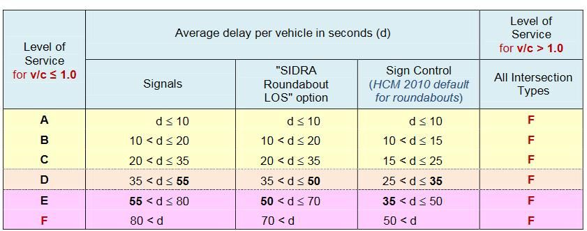
1. Introduction
1.1 Background and Purpose of the Study
The Industrial Development Corporation (IDC) appointed Aecom to prepare a feasibility study for the
development of a new visitor attraction at God’s Window which is located in the Blyde River Canyon
Naional Park in Mpumalanga. The study was completed in April 2013.
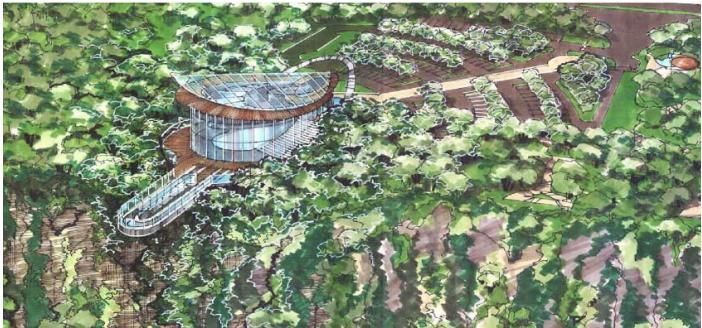
The proposed Skywalk concept will include a cantilevered glass walkway that will protrude from the
Canyon’s edge, together with a main building which will house a cafeteria and a gift shop. The Skywalk
will form part of a larger redevelopment of God’s Window which will include the improvement of the
existing walkways, viewpoints and car park.
1.2 Purpose of the Study
WSP Group Africa (Pty) Ltd was appointed by Strategic Environmental Focus (SEF) in July 2013 to
undertake a Transport Impact Assessment (TIA) for the proposed Skywalk at God’s Window in the
Blyde River Canyon, near Graskop in the Mpumalanga province.
The TIA has been prepared as part of the Environmental Impact Assessment (EIA) being prepared by
Strategic Environmental Focus (SEF) for the proposed development. The EIA is undertaken on behalf
of the IDC.
The TIA covers, among others, the following:
The impact of the proposed changes and additions to the existing God’s window tourist attraction
on the existing road and transportation infrastructure and
The mitigation measures required to accommodate the proposed changes to the God’s window
and associated land-uses within acceptable norms.
1.3 The Study Area
God’s Window is located on the ridge of the Blyde River Canyon within the Thaba Chweu Local
Municipality, which is part of the Ehlanzeni District Municipality, in Mpumalanga. God’s Window is
situated approximately 9.2km north of the town of Graskop. Its regional and local locality is shown in
Figures 1.1 and 1.2. It is located east of Johannesburg and Pretoria near the Kruger National Park.
The Blyde River Canyon National Park is a ‘unique natural environment, with dramatic views across
the world’s deepest canyon and dramatic rock formations. Views from God’s Window extend down to
the lowveld, across to the distant Kruger National Park’, Aecom, 2013.
Project number: 16700.R
Dated: 2013/08/01 8
Revised:
2. Introduction

2.1 Extent of the Study

2.1.1 The size of the land in question

       The site of God’s Window sits on land owned by a collection of local communities. Whilst it does not
       have a clearly defined boundary, it is estimated that the main area of the God’s Window site (parking
       area, ablution facility and area up to the ridge) is around 25 000m 2 in extent.

       The area between the existing parking area and the ridge is considered as a ‘disturbed area’ due to
       prior environmental degradation. There is an additional area of some 50 000m 2 (forested zone) that
       leads up to the highest viewpoint.

2.1.2 Preliminary summary of the different land uses that will be investigated

       The vision for the Skywalk at God’s Window is to create a cantilevered glass walkway that protrudes
       12m from the ridge of the canyon, offering 360° panoramic views and a sheer drop below. The
       redevelopment of the wider site would significantly enhance the existing observation areas and guest
       services and create a new visitor building containing a shop for food and beverages.

       The initial designs depicts an improved car parking and service area, a new visitor centre and
       improved retail area for local craftspeople that currently trade from stalls at Gods Window.

2.1.3 A preliminary indication of the total trip generation

       The total trip generation for the 2016 and 2021 Horizon year was estimated based on the on-site
       attendance for Gods Window (Aecom report) together with vehicle occupancy data obtained through
       new/additional surveys conducted on the 2 and 3 August 2013.

       The preliminary trip generation estimates show the following peaks:

           106 peak hour traffic (vehicles) in 2016 and
           114 peak hour traffic (vehicles) in 2021.

2.1.4 An indication as to whether a TISm / comprehensive traffic study is required

       According to the Manual for Traffic Impact Studies (Department of Transport, 1995), when a proposed
       development or change in land use will generate more than 150 development trips in the peak hour, a
       Traffic Impact Assessment report needs to be prepared.

                                                       9
Thus, in light of the estimated vehicle trips, there is no requirement to prepare a full Traffic Impact
            Study. However, due to the impact this development will have on the Mpumalanga Province, a
            comprehensive Traffic Impact Study has been prepared.

  2.1.5 Investigated Peak Periods

            As previously stated Gods Window is a tourist attraction/recreational area and thus the peak periods
            which have been investigated are those corresponding to the daily peaks (based on the new traffic
            surveys) of this particular land use.

            The applicable peak periods are the following:

                Friday peak – 16:15 to 17:15 and
                Saturday peak – 13:00 to 14:00

  2.1.6 Horizon Years

            The 2016 and 2021 horizon years have been investigated as part of this TIS. These horizon years
            have been selected to coincide with the visitor estimates as included in the Aecom’s Feasibility Study.
            Thus the traffic impacts which have been assessed as part of this TIS will speak to the effects of the
            increase in tourist numbers for the 2016 and 2021 scenario.

   2.2 Latent Rights

           Proposed developments within the immediate vicinity of Gods Window are discussed in this section. As
           these developments are only planned and are not yet approved, their development traffic could not be
           considered.

  2.2.1 Proposed Cableway

           The Industrial Development Corporation (IDC) is promoting the development of a cableway which              will
           link the Forever Resort Blyde Canyon, situated close to the Three Rondavels, across                        the
           Blyderivierspoort Reservoir to the Forever Resort Swadini in the lowveld. A feasibility study              will
           evaluate the commercial viability of the proposal. This development has the potential to establish         the
           Park as a strategic attraction and overnight stop on the Panorama Tour Route.

Project number: 16700.R
Dated: 2013/08/01                                            10
Revised:
2.2.2 Adventure Centre
The proposed adventure centre will be located in the town of Graskop. It will provide a number of
suspended walkways and will also include a cliff walk, a treetop walkway with a zip line, a big swing
and children’s play area along with observation deck and food and beverage offers.
2.2.3 Bourke’s Luck Potholes
The proposed development includes for a five-star lodge and a restaurant. However the project has
stalled, though initial consent was attained.
2.3 Scenarios Investigated
The following traffic scenarios have been investigated as part of this Traffic Impact Study:
2013 Background Traffic (Base Year);
2016 Horizon Traffic due to traffic growth; and
2016 Total Traffic (2016 Horizon Traffic and Development Traffic).
2.4 Assumptions
The trip generated by the proposed development/upgrade have been estimated based on the peak on-
site attendance at God’s Window estimated in the Aecom’s Feasibility Report together with the vehicle
occupancy estimates from our traffic surveys.
113. Selected Policy and Planning Issues
3.1 Introduction
The presence of adequate transport infrastructure is a pre-requisite of a developing tourism industry. It
is also an important platform on which tourism plans and investment initiatives can be built. The non-
availability and/or lack of public transport links inhibit the spread of tourists and residents within a
particular destination and hamper growth in the tourism industry.
This section of the report has reviewed the current transportation policies and planning which supports
tourism development in Mpumalanga.
3.2 Ehlanzeni District Municipality Comprehensive Integrated Transport
Plan (April 2008)
A Comprehensive Integrated Transport Plan (CITP) was prepared for the Ehlanzeni District
Municipality (EDM) in 2008. The EDM is one of three district municipalities which are located within
the Mpumalanga Province (Nkangala and Gert Sibande being the other two), and also includes the
provincial seat of government.
As previously stated, God’s Window is located within the Thaba Chweu Local Municipality and only
information relevant to this municipality has been discussed in the sections which follow.
From the CITP, the following modal split is evident:
Walking – 43.3%;
Private Vehicle – 16.3%;
Bus – 9.0%;and
Mini-bus taxi – 8.7%
The modal split indicated is typical of a rural area in comparison to an urban modal split. As seen,
walking is the predominant mode of transport in the Municipality’s area of jurisdiction.
3.3 Mpumalanga Economic Growth and Development Plan
The economic growth plan for the province focuses on job creation and the reduction of poverty. The
plan has outlined key employment targets, which are, from the government’s point of view, deemed
achievable. As a result of these initiatives, Mpumalanga is envisioned to benefit from the creation of an
extra 720 000 jobs by 2020. The development of successful tourist projects should assist in this, both
directly and indirectly.
Project number: 16700.R
Dated: 2013/08/01 12
Revised:3.4 Blyde River Canyon Tourism Development Strategy
3.4.1 Introduction
The established vision for the Blyde River Canyon National Park is stated as follows:
“The Blyde River Canyon National Park, in partnership with local communities, will become recognised
internationally as one of the world’s leading parks by protecting and promoting its unique landscapes,
biodiversity and rich cultural assets.”
A strategy has been drafted to ensure that tourism development in the Blyde River Canyon National
Park meets its desired aims. The strategy states that “The Park should act as a catalyst for tourism
development in areas around the Park, particularly for the town of Graskop.”
Developing the Blyde River Canyon (BRC) National Park as a primary tourist attraction has long term
tourism driven economic benefits for the Park’s immediate hinterland and other rural areas along the
Gauteng-Kruger tour route. BRC National Park needs to be further developed to provide a suitable
range of appropriate tourism products in order to optimise the full extent of the tourism opportunities
that it can derive from its status as a national park.
3.4.2 Benefits to the Provincial Economy
The benefits to the development of the Blyde River Canyon National Park have been stated as follows:
The Panorama Tour route may be extended by one day creating the potential for further
development in other areas along the route;
That it will catch and keep longer the flow of nearly half million tourists that travel past the Park on
the Gauteng to Kruger tour route thus contributing significantly to the local surrounding economy;
The Park will create considerable permanent and temporary jobs, business opportunities and
opportunities for local people involved in the development of the Park; and
The associated high service level of infrastructure necessary to support such tourism will have
indirect, but significant benefits for local communities living in the area
The Skywalk concept is one that would bring the local area to international prominence. The
development will significantly enhance the tourism product offer in the area, as well as creating an
attraction with appeal to both domestic and international visitors. The proposed Blyde River Canyon
cableway development, amongst other enhancement schemes, would further improve the perception
of the area as a destination in its own rights.
134. Existing Roadway Elements
4.1 Existing Road Network
Access to the God’s Window is gained via the main route to and from Graskop, the R532. The R534 off
the R532 provides direct access to the God’s Window tourist attraction.
The R534 can be classified as a Class 2 Rural Major Arterial which forms a spur loop. It is a single
carriageway road which connects to the R532 at its northern and southern end. Deceleration and
acceleration lanes are provided along the R532 to the north and south. There were no posted speed
limit signs along the R534, but due to the class of the road, the speed limit can be assumed to be
100km/hr.
The R532 can be classified as a Class 2 Rural Major Arterial which runs in a north-south direction. It is
a single carriageway road which leads to the small forestry town of Graskop. The observed speed limit
along the R532 is 100 km/hr.
4.2 Roadway Conditions
The R532 and R534 which provide direct access to Gods Window are in a relatively good condition and
are adequately maintained.
4.3 Roadway Restrictions
The only observed roadway restriction are the posted speed limit signs and the prohibition on littering
along the R534.
4.4 Non-Motorised Transport
Due to the class of the access roads to God’s Window, the R532 and R534, facilities for non-motorised
transport and disabled and vulnerable users are not provided along the roads.
4.5 Public Transport Facilities
Public transport stops are not provided along the R532 and R534. Parking for buses is provided outside
the entrance to God’s Window
Project number: 16700.R
Dated: 2013/08/01 14
Revised:5. Existing Public Transport
5.1 Minibus Taxi
The following relevant information pertaining to minibus taxis was obtained from the Ehlanzeni District
Municipality’s CITP:
Name of Taxi Association – Graskop Local and Long Distance Taxi Association;
Number of Vehicles – 80 vehicles;
Number of Members – 93 members;
Number of Operating Licences – 61 licences
The nearest taxi rank facility to God’s Window is located in the town of Graskop. Table 5.1 shows the
facilities available at the Graskop Taxi Rank.
Table 5.1: Available Facilities at Graskop Taxi Rank
2
Name Area (m ) or Status Amenities Paving Off-Street
bays
Graskop 950 Formal O, A Y N
E= Electricity, T = telephone, O = office, A = Ablutions
Minibus taxi trips can be taken from Graskop to the nearby towns of Lydenburg, Sabie and Matibidi and
even as far away as Gauteng. Minibus taxi and MB Shuttles trips to God’s Window were observed
during the traffic surveys at God’s Window.
5.2 Commuter Bus Operations
There are currently no subsidised/unsubsidized commuter bus services within the Thaba Chweu Local
Municipality.
The only buses which were observed serving the God’s Window were the tourist buses/coaches.
5.3 Rail Operations
The railway line from Nelspruit to the town of Graskop was completed in 1913 and the first train arrived
in Graskop in May 1914.The railway line is situated about 14.5km from Pilgrim’s Rest and 32km from
Sabie. However, the railway system does not currently serve commuters with this study area.
155.4 Summary
From the above, it is evident that the minibus taxi is currently the only form of public transport that is
available to transport passengers to/from Graskop in the Thaba Chweu Local Municipality.
6. Planned Changes to the Existing Road Network
From the team’s consultations with officials from the Thaba Chweu Local Municipality, it was confirmed
that there are no planned changes or improvements to the existing road network.
Project number: 16700.R
Dated: 2013/08/01 16
Revised:7. Existing Traffic
7.1 Traffic Surveys
New intersection traffic count surveys were undertaken on 2nd (Friday) & 3rd (Saturday) August 2013
from 06:00 to 18:00 by Messrs Traffic Support Services (TSS) at the following intersections:
R532 & R534 North;
R532 & R534 South; and
God’s Window Access off the R534.
These surveys were supplemented by vehicle occupancy surveys together with number plate surveys
of vehicles (in and out movements) visiting the God’s Window tourist attraction.
The location of the intersections is as indicated in Figure 7.1.
A copy of the traffic survey data is included in Appendix A.
7.2 Peak Traffic Hours
The ‘common’ peak hours were determined from the traffic counts as follows:
Friday peak – 16:15 to 17:15 and
Saturday peak – 13:00 to 14:00
7.3 2013 Background Traffic
The traffic counts were used to determine the background traffic volumes in the vicinity of God’s
Window tourist attraction. The results of the Friday and Saturday peak hour background traffic counts
are shown in Figures 7.2 to 7.3.
7.4 Adjustment of Background Traffic
Seasonal factors are parameters used to adjust base counts which to account for travel behaviour
fluctuations by day of the week and month of the year.
17Visitor volumes to Gods Window vary throughout the year, as shown by the historic visitor volumes in
Figure 7.4. The detail summary of the March 2009 to February 2010 of God’s Window visitor numbers
is included in Appendix B.
Gods Window Visitor Numbers (2009/2010)
40 000
35 000
30 000
Number of Visitors
25 000
20 000
15 000
10 000
5 000
0
Months of the Year
Figure 7.4: God’s Window visitor numbers (2009/2010)
From Figure 7.4 the following is noted:
Approximately 20 000 people visited God’s Window during the April holiday period and the month
of August; and
Approximately 35 000 people visited God’s Window during the December holiday peariod.
Therefore the base traffic counts were adjusted by a factor of 1.75 to make allowances for the lower
traffic volumes experienced in the month of August to December.
The adjusted background traffic counts are shown in Figures 7.5 and 7.6.
7.5 Traffic Conditions
The roads in the immediate vicinity of Gods Window carry low levels of traffic and thus traffic
congestion is not currently a problem.
However, during peak times (weekends, school and public holidays), traffic congestion occurs as
visitors try to find parking within the Gods Window site. When parking is not sufficient they end up
finding parking at the nearby viewpoints and along the roads near the access.
Project number: 16700.R
Dated: 2013/08/01 18
Revised:7.6 Traffic Growth
The future tourist market for the Mpumalanga province has been projected to grow at an annual growth
rate of 2.2%.
An annual growth rate of 2.0% was applied to the adjusted 2013 background traffic volumes to
estimate the 2016 and 2021 horizon traffic.
The estimated 2016 and 2021 horizon traffic for the Friday and Saturday peak hours is shown in
Figures 7.7 to 7.10.
198. Trip Generation
8.1 Trip Generation of new and/or revised land uses
The feasibility study prepared by Aecom, on behalf of the Industrial Development Corporation, provided
estimates of attendance for the proposed Skywalk at God’s Window. These estimates were produced
through a ‘market penetration rate analysis which measures the propensity of available market
segments to visit the viewpoint’.
The estimate of peak on-site visitor attendance at the improved God’s Window tourist attraction (with
the proposed Skywalk):
Skywalk’s Maximum Hourly Capacity – 215 guests per hour;
Peak on-site attendance for God’s Window – 453 people in 2016
Peak on-site attendance for God’s Window – 487 people in 2021
The estimate of existing modal split at God’s window is based on the assessment of the vehicle
occupancy surveys done on the 3rd August 2013. The 3rd of August was a clearer day than the 2nd of
August and this resulted in a higher number of visitors to the site (visibility to the Lowveld area is
essential to experience the full splendour of God’s Window and the nearby Wonderview.)
The estimated modal split for visitors is shown in Figure 8.1.
Buses &
Coaches, 24%
Mini/Midibus
Taxis & Light Vehicle,
Shuttles, 14% 62%
Figure 8.1: Existing Modal Split at God’s Window
The above modal split estimate was used as the basis for the calculation of the peak hour traffic
volumes that will be generated in 2016 and 2021.
Project number: 16700.R
Dated: 2013/08/01 20
Revised:The following are the estimates of vehicle occupancies, based on the traffic surveys, for the various
modes:
Light Vehicle – 2.87 persons/vehicle;
Minibus Taxis – 10 persons/vehicle; and
Buses – 53.1 persons/vehicle
The trip generation estimates are provided in Table 8.1.
Table 8.1: Peak Hour Vehicle Estimates
2016 2021
Vehicle Type
Peak Hour Volumes
Light Vehicle 98 105
Mini/Midibus Taxi 6 7
Buses 2 2
Total 106 114
Thus in 106 and 114 vehicles can be expected in 2016 and 2021 respectively.
219. Trip Distribution
9.1 Trip Distribution Percentages
It was estimated that the development traffic will distribute on to the surrounding public road network as
follows:
65 % to/from the South (Graskop) via the R532 and
35% to/from North via the R532.
The estimated distributions are shown in Figure 9.1.
The generated trips were assigned to the external road network based on the trip distribution
percentages. The development trips for 2016 and 2021 are shown in Figures 9.2 and 9.3.
The development trips were added to the 2016 Horizon Traffic and the 2021 Horizon Traffic to
determine the 2016 Total Traffic in Figure 9.4 and 2021 Total Traffic in Figure 9.7.
Project number: 16700.R
Dated: 2013/08/01 22
Revised:10. Capacity Analysis
The following intersections were assessed in terms of current and future traffic operations and capacity:
R532 & R534 North;
R532 & R534 South; and
God’s Window access off the R534.
10.1 Definitions
The following definitions from the Highway Capacity Manual (TRB, 2001) are used in this chapter.
Capacity The maximum hourly rate at which vehicles can
reasonably be expected to traverse a lane or
roadway during a given period under prevailing
traffic control conditions
Volume The hourly rate of vehicle arrivals at an
intersection.
Volume to Capacity Ratio The ratio of volume to capacity (V/C) also referred
to as the saturation flow rate
Level of Service Level of service is defined in terms of delay. Delay
is a measure of driver discomfort, frustration, fuel
consumption and lost travel time. The levels of
service for signalised and non-signalised
intersections as defined in the Highway Capacity
Manual (HCM) are tabulated in Table 10.2
2310.2 Modelling Software
The software SIDRA Intersection v.5 was used in analysing the operation and capacity of the
intersections under investigation. SIDRA is an advanced micro-analytical traffic evaluation tool that
employs lane-by-lane and vehicle drive-cycle models coupled with an iterative approximation method
to provide estimates of capacity and performance statistics i.e. delay, queue length, stop rate, etc.
(Akcel& Associates, 2006)
The SIDRA intersection software is for use as an aid for the design and evaluation of the following
intersection types:
Signalised intersections (fixed-time, pre-timed and actuated),
Signalised pedestrian crossings,
Single point interchanges (signalised)
Roundabouts
Two-way stop control,
All-way stop control, and
Give-way (yield) sign control
Although SIDRA is a single intersection analysis package, it can perform traffic signal analysis as an
isolated intersection (default) or as a co-ordinates intersection by specifying platooned arrival data.
The flexibility of SIDRA allows its application to many other situations, including uninterrupted traffic
flow conditions.
10.3 Revised level of service method for vehicles in HCM 2010
In SIDRA Intersection v5.1, Level of Service (LOS) results are given for all major road lanes and
movements except any continuous lanes. Usually LOS A or B will result due to zero delay (or
geometric delay only for turning vehicles). However, LOS results are not given for major road
approaches in line with the Highway Capacity Manual (HCM) 2010, unlike in earlier versions of SIDRA
Intersection.
The method used for vehicle level of service at Approach and Intersection level is summarised in
Table 10.1.
Table 10.1: Method used for level of service at Approach and Intersection level
LOS Method Site Type Approach LOS Intersection LOS
Delay (HCM 2000) Two-Way Sign Average approach N/A
Control (Stop or delay for Minor Road
Delay & v/c (HCM
Give-Way / Yield) approaches
2010)
N/A for Major Road
Delay (RTA NSW)
approaches
Others Average approach Average intersection delay
delay
Project number: 16700.R
Dated: 2013/08/01 24
Revised:Degree of Saturation All Site Types Highest (worst Highest (worst movement /
(SIDRA Method) movement / lane) lane) degree of saturation
degree of saturation for the intersection
ICU Method
for the approach
A revised LOS method for vehicles was introduced in HCM 2010 (TRB 2010). It offers an important
variation on the Delay (HCM 2000) method in using both the average control delay and the v/c
(demand volume / capacity) ratio, or degree of saturation for LOS determination.
It uses delay thresholds which are the same as in the Delay (HCM 2000) method, but assigns LOS F
when v/c > 1.0 (oversaturated conditions) irrespective of delay, as seen in Table 10.2.
Table 10.2: Delay & v/c (HCM 2010) definitions for LOS based on delay and v/c ratio
Note: v/c (demand volume / capacity) ratio, or degree of saturation: v/c > 1.0 represents oversaturated conditions.
This method replaces the Delay (HCM) & Degree of Saturation method which was available in earlier
versions of SIDRA Intersection. In applying the Delay & v/c (HCM 2010) method:
the v/c ratio (degree of saturation) is taken into account together with the average delay value in
determining LOS for lanes and movements, but
only the average delay value is considered in determining LOS for approaches and the
intersection (special considerations apply to LOS for approaches and the intersection as a whole
in the case of two-way sign control).
A summary of the analysis results is discussed hereafter. Detailed analysis results are provided in
Appendix C.
2510.4 2013 Background Traffic
10.4.1 R532 & R534 North
The intersection geometry of R532 & R534 North is shown in Figure 10.4.1.
Figure 10.4.1: Existing Geometry R532
& R534 North
The analysis results show that R534 North operates at LOS B during both the Friday and Saturday
peak hour with maximum movement average delays of 12.7 and 11.4 seconds during the Friday and
Saturday peak hours respectively.
Project number: 16700.R
Dated: 2013/08/01 26
Revised:10.4.2 R532 & R534 South
The intersection geometry of R532 & R534 South is shown in Figure 10.4.2.
Figure 10.4.2: Existing Geometry of R532 &
R534 South
The analysis results show that R534 South operates at LOS B during both the Friday and Saturday
peak hours with maximum movement average delays of 12.0 and 12.3 seconds during the Friday and
Saturday peak hours respectively.
2710.4.3 God’s Window Access off the R534
The intersection geometry of God’s Window off the R534 is shown in Figure 10.4.3.
Figure 10.4.3: Existing Geometry of God’s
Window access off the R534
The analysis results show that the Gods Window Access operates at LOS B during both the Friday
and Saturday peak hour with maximum average delays of 11.2 and 11.4 during the Friday and
Saturday peak hours respectively.
10.5 2016 Horizon Traffic
10.5.1 R532 & R534 North
The analysis results show that R534 North operates satisfactorily at LOS B during both the Friday and
Saturday peak hours with maximum movement average delays of 13.0 and 12.4 seconds during the
Friday and Saturday peak hour respectively.
10.5.2 R532 & R534 South
The analysis results show that R534 South operates satisfactorily at LOS B during both the Friday
and Saturday peak hours with maximum movement average delays of 12.1 and 12.4 seconds during
the Friday and Saturday peak hour respectively.
Project number: 16700.R
Dated: 2013/08/01 28
Revised:10.5.3 God’s Window Access off the R534
The analysis results show that the Gods Window access operates well at LOS B during both the
Friday and Saturday peak hours with maximum movement average delays of 11.2 and 11.4 seconds
during the Friday and Saturday peak hour respectively.
10.6 2021 Horizon Traffic
10.6.1 R532 & R534 North
The analysis results show that R534 North operates at LOS B during both the Friday and Saturday
peak hours with maximum movement average delays of 13.2 and 12.6 seconds during the Friday and
Saturday peak hours respectively.
10.6.2 R532 & R534 South
The analysis results show that R534 South operates at LOS B during both the Friday and Saturday
peak hours with maximum movement average delays of 12.2 and 12.7 seconds during the Friday and
Saturday peak hours respectively.
10.6.3 God’s Window Access off the R534
The analysis results show that the Gods Window access operates well at LOS B during both the
Friday and Saturday peak hours with maximum movement average delays of 11.2 and 11.5 seconds
during the Friday and Saturday peak hour respectively.
10.7 2016 Total Traffic
10.7.1 R532 & R534 North
The analysis results show that R534 North operates satisfactorily at LOS B during both the Friday and
Saturday peak hours with maximum movement average delays of 13.1 and 12.5 seconds during the
Friday and Saturday peak hour respectively.
10.7.2 R532 & R534 South
The analysis results show that R534 South operates satisfactorily at LOS B during both the Friday
and Saturday peak hours with maximum movement average delays of 12.1 and 12.7 seconds during
the Friday and Saturday peak hour respectively.
2910.7.3 God’s Window Access off the R534
The analysis results show that the Gods Window access operates well at LOS B during both the
Friday and Saturday peak hours with average delays of 11.5 and 12.0 seconds during the Friday and
Saturday peak hour respectively.
10.8 2021 Total Traffic
10.8.1 R532 & R534 North
The analysis results show that R534 North operates at LOS B during both the Friday and Saturday
peak hours with maximum movement average delays of 13.4 and 12.8 seconds during the Friday and
Saturday peak hours respectively.
10.8.2 R532 & R534 South
The analysis results show that R534 South operates at LOS B during both the Friday and Saturday
peak hours with maximum movement average delays of 12.2 and 13.0 seconds during the Friday and
Saturday peak hours respectively.
10.8.3 God’s Window Access off the R534
The analysis results show that the Gods Window access operates well at LOS B during both the
Friday and Saturday peak hours with maximum movement average delays of 11.5 and 12.2 seconds
during the Friday and Saturday peak hour respectively.
10.9 Summary
The analysis results show that the intersections on the immediate road network will continue to
operate satisfactorily for all the assessed traffic scenarios.
Project number: 16700.R
Dated: 2013/08/01 30
Revised:11. Public Transport Assessment
“Tourist travel has predictable patterns and needs, and often occurs in areas that have unique
environmental and social features that are particularly sensitive to degradation by excessive
automobile traffic. Tourist Travel Management can preserve the amenities that attract visitors to an
area”, (TDM Encyclopaedia, 2011)
Thus encouraging environmentally sustainable travel to holiday/recreational areas is crucial to
maintaining the attractiveness of a recreational site.
38% of travel to Gods Window is made by mass transit vehicles (24% tourist and school buses with
14% being minibus taxis and shuttles). Thus, it is important to ensure that facilities for mass transit
vehicles are maintained and improved at God’s Window.
Reserved on-street parking for mass transit vehicles is currently provided adjacent to the God’s
Window access as shown in Figure 11.1. During off-peak seasons, buses are allowed to park within
the parking area of God’s Window.
Figure 11.1: Reserved On-Street Parking for Buses & Public Transport Vehicles
The following can increase the use of mass transport vehicles to God’s Window:
Make it affordable, convenient and enjoyable to Visit God’s Window without having to use a
private vehicle;
Provide detailed information on available travel choices to God’s Window at Graskop;
Provide benefits to visitors who arrive without a car, e.g. priority access for buses;
Create functional and attractive pedestrian and cycling facilities;
Formalise bus parking area outside God’s Window, by means of demarcation of bays; provide
bus shelters, etc.
31Provide signage for buses on the approaches to Gods Window; and
Provide signage for alternative parking (spill over parking) when the existing parking is fully
utilised.
Project number: 16700.R
Dated: 2013/08/01 32
Revised:12. Parking
The existing parking at God’s Window is a combination of angled and parallel parking which is used
by light vehicles, minibus taxis and tourist buses.
The parking fee paid at the entrance is not linked to the parking duration. The number plate survey of
vehicle entry and exits from God’s Window, showed that on average vehicles parked for a period of
48 min at the parking area.
According to Parking Management Strategies, (Todd Litman, 2011), the following are just some
strategies that can be used to better manage parking at Gods Window:
Encourage the use of alternative modes and reduce motor vehicle use;
Provide information to visitors about minibus taxi services and ridesharing;
Develop a contingency-based overflow parking plan that indicates where is available parking
nearby if on-site facilities are full (e.g. during holidays, weekends and school holidays) and how
spillover impacts will be addressed;
Improve enforcement, marketing and mobility management programs which encourage the use
of alternative modes.
The use of some of these strategies can assist in managing parking demand at Gods Window. When
parking is better managed, the cost of building expensive parking areas and its associated
environment impacts is reduced.
3313. Conclusions & Recommendations
The following conclusions can be made:
A Transport Impact Assessment was prepared to assess the impact of the proposed changes to
the existing God’s Window tourist attraction, in Mpumalanga, on the existing road and
transportation infrastructure;
It is estimated that proposed changes in land use at the God’s Window access will result in 106
and 114 peak hour traffic in 2016 and 2021 respectively;
The surrounding intersections, R532 & R534 North, R532 & R534 South, and the God’s Window
access have been assessed in terms of current and future traffic operations;
The assessment results show that the intersections are currently operating at satisfactorily levels
of service for the 2013 Background Traffic Scenario;
The assessment results show that the intersections will continue to operate at satisfactorily levels
during the 2016 Horizon and 2016 Total Traffic scenario;
The assessment results show that the intersections will continue to operate at satisfactorily levels
during the 2021 Horizon and 2021 Total Traffic scenario;
No intersection upgrades are proposed to the immediate surrounding road network.
It is recommended that the Transport Impact Assessment is approved from a traffic engineering point
of view, with a proviso that the following is accommodated:
Make it affordable, convenient and enjoyable to Visit God’s Window without having to use a private
vehicle;
Provide detailed information on available travel choices to God’s Window at Graskop;
Provide benefits to visitors who arrive without a car, e.g. priority access for buses;
Create functional and attractive pedestrian and cycling facilities;
Formalise bus parking area outside God’s Window, painting of bays; provide bus shelters
Provide signage for buses on the approaches to Gods Window;
Provide signage for alternative parking (spill over parking) when the existing parking is fully
utilised.
Project number: 16700.R
Dated: 2013/08/01 34
Revised:14. References
The following references have been used in the compilation of this report:
Aecom, 2013. Feasibility Study Report for the proposed Skywalk at God’s Window. Aecom, April.
DoEAT, Blyde River Canyon National Park – Tourism Development Strategy, undated. Department of
Environmental Affairs and Tourism.
Mpumalanga Province’s Tourism Industry Statistics, 2007/2008.
Mpumalanga Tourism Fact Sheet 2007/2008, Mpumalanga Tourism and Parks Agency.
Campbell Scott et al.2009. Skywalk Complex and Skylift at Gods Window – Blyde River Canyon
Nature Reserve, December.
Hazyview Areal Cable Trails (Pty) Ltd T/A Skyway Trails. Undated. Feasibility Study for the
Development of a Skywalk complex and Skylift at God’s Window
Victoria Transport Policy Institute, 2011 Tourist Transport Management, Improving Leisure Travel
Choices, TDM Encyclopaedia. Updated 18 February 2011.
Todd Litman, 2011. Parking Management Strategies, Evaluation and Planning. Victoria Transport
Policy Institute, 2011Figures Project number: 16700.R Dated: 2013/08/01 Revised:
Appendices
Appendix A: Traffic Survey Data

Project number: 16700.R
Dated: 2013/08/01
Revised:
Appendix B: Detailed Summary of 2009/2010 God’s
            Window Visitor Numbers
Appendix C: Summary of SIDRA Analysis Results Project number: 16700.R Dated: 2013/08/01 Revised:
2013 Background Traffic
2016 Horizon Traffic

Project number: 16700.R
Dated: 2013/08/01
Revised:
2021 Horizon Traffic
2016 Total Traffic

Project number: 16700.R
Dated: 2013/08/01
Revised:
2021 Total Traffic
WSP Group Africa (Pty) Ltd
WSP House
Bryanston Place, 199 Bryanston Drive
Bryanston
2191
South Africa
Tel: +27 12 349 1307
Fax: +27 12 349 1229
www.wspgroup.co.za
You can also read