Analysis of Rainfall and Temperature Variations between 1956 and 2016 for Papua New Guinea
←
→
Page content transcription
If your browser does not render page correctly, please read the page content below
Journal of Geoscience and Environment Protection, 2021, 9, 66-85
                                                                                                https://www.scirp.org/journal/gep
                                                                                                          ISSN Online: 2327-4344
                                                                                                            ISSN Print: 2327-4336

Analysis of Rainfall and Temperature
Variations between 1956 and 2016 for Papua
New Guinea

Nathan Sapala, Yuanyuan Cheng*, Dapeng Li*

School of Environmental Science and Engineering, Suzhou University of Science and Technology, Suzhou, China

How to cite this paper: Sapala, N., Cheng,     Abstract
Y. Y., & Li, D. P. (2021). Analysis of Rain-
fall and Temperature Variations between        The aim of the research was to assess the trend and variations in rainfall and
1956 and 2016 for Papua New Guinea.            temperature in Papua New Guinea between 1956 and 2016 (60 years) and
Journal of Geoscience and Environment Pro-     project the trends from 2017 to 2047 (30 years). Meteorological data obtained
tection, 9, 66-85.
https://doi.org/10.4236/gep.2021.96004
                                               from the World Bank Climate Database Headquarters in Washington, United
                                               States, from 1956 to 2016 were used in the models. The general linear model
Received: June 1, 2021                         analysis was used to investigate the trend in both rainfall and temperature
Accepted: June 15, 2021
                                               and to predict the future trends. Over the period of study period, 1956 to
Published: June 18, 2021
                                               2016, the study found that the climatic factors, rainfall and temperature pat-
Copyright © 2021 by author(s) and              tern in Papua New Guinea have been changing. It was found that there is an
Scientific Research Publishing Inc.            increasing trend in rainfall and temperature. Projections revealed a further
This work is licensed under the Creative
                                               increase in rainfall and temperature into the future. Rainfall in Papua New
Commons Attribution International
License (CC BY 4.0).
                                               Guinea has been increasing. The projection revealed that rainfall was trend-
http://creativecommons.org/licenses/by/4.0/    ing upward with a linear model equation: Rainfall = 0.0093x + 252.38. The
                Open Access                    increased trend in rainfall suggests that there is an increased trend in evapo-
                                               ration and transpiration. For temperature, although it does not come down to
                                               zero and to negative at nights or go up to 40˚C or 50˚C during the day time as
                                               in other countries, the change is clear in the analysis made in the study that
                                               there is an increasing trend. If nothing is done to combat the current rate of
                                               climate change in the country, the increasing trend in rainfall and tempera-
                                               ture would continue. This calls for immediate actions as the issue needs to be
                                               addressed in time. Therefore, it is recommended that the government of Pa-
                                               pua New Guinea consider incorporating climate change policies into their
                                               development plans.

                                               Keywords
                                               Rainfall, Temperature, Climate Change, Papua New Guinea

DOI: 10.4236/gep.2021.96004         Jun. 18, 2021                66             Journal of Geoscience and Environment Protection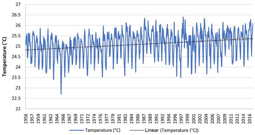
N. Sapala et al.

                              1. Introduction
                              Climate change is the greatest threat to global health in the 21st century (WHO,
                              2015). Changes in climate are already affecting species’ distribution patterns
                              (Cámara-Leret et al., 2019). No level of ecosystem restoration would offset the
                              impacts of climate change where global average temperatures would increase by
                              3˚C to 6˚C by 2100 (CSIRO, 2015). Studies show that increase in rainfall is due
                              linked to climate change. Rainfall extremes are increasing around the world, and
                              the increase is linked to the warming of the atmosphere, due to climate change,
                              which has taken place since pre-industrial times (Seth, 2013).
                                 Papua New Guinea (PNG), one of the 10 most affected countries by climate
                              change, is already feeling the effect of climate change (Sungkuk & Ibrahim,
                              2015). A remote-sensing study showed that shoreline changes on Takú Atoll
                              were remarkably variable with respect to both spatial and temporal dimensions.
                              Long-term analyses of planform shoreline configurations, net changes in island
                              area and the spatial variability of significant shoreline change rates from 1943 to
                              2012 indicated a trend towards island accretion (Mann & Westphal, 2016).
                                 A joint study made by the Pacific Climate Change Science Program (PCCSP),
                              Commonwealth Scientific and Industrial Research Organisation (CSIRO) and
                              the Papua New Guinea national weather services (NWS) revealed that the
                              sea-level rise near Papua New Guinea measured by satellite altimeters (1993-2016)
                              is about 7 mm per year (Kaluwin, Inape, & Virobo, 2016). The joint study also
                              reveals that warming trends are evident in both annual and seasonal mean air
                              temperatures in the capital of PNG (at Port Moresby) for the period 1950-2009.
                              These trends are considerably stronger in minimum air temperatures when
                              compared to maximum air temperatures (Kaluwin et al., 2016).
                                 PNG is already home to the world’s first climate change refugees from its
                              Carteret atolls in its Bougainville Island Province (IOM, 2008).
                                 The specific objectives of this paper are as follows:
                                 1) To examine the trends in rainfall and temperature in Papua New Guinea
                              (1956-2016),
                                 2) To investigate the variation in rainfall and temperature in Papua New Gui-
                              nea (1956-2016), and
                                 3) To make 30-year projections of rainfall and temperature for Papua New
                              Guinea.
                                 In order to achieve the objectives, the hypothesis that there is no change in
                              temperature and rainfall variability in Papua New Guinea was tested.

                              2. Research Methodology
                              2.1. Study Area
                              Papua New Guinea is a country in Oceania, located on the northern tip of Aus-
                              tralia, at latitude between 2˚ to 11.3˚ south and longitude between 141˚ to 157.2˚
                              east. It has two major international boundaries with the West Papua Province of
                              Indonesia to the West and Australia to the South. The other international land

DOI: 10.4236/gep.2021.96004                        67             Journal of Geoscience and Environment Protection
N. Sapala et al.
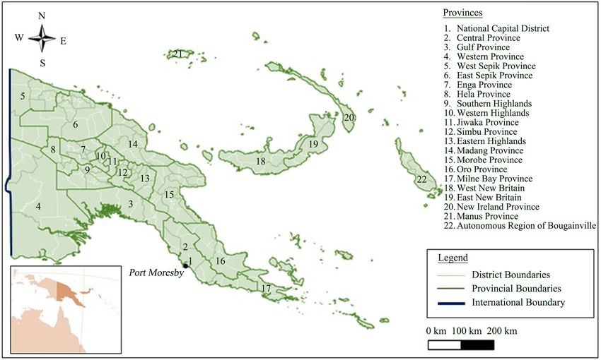
boarders include Solomon Island, Vanuatu, and Fiji all to the South-east. Figure
1 shows the map of Papua New Guinea and its provinces where the rainfall and
temperature data used in this work have been collected.
The country (shown in Figure 1) covers a total land area of 46.9 million hec-
tors (CCDA, 2018). PNG has one of the biggest tropical forest in the world. Its
forest covers 80% of the country’s land area (CCDA, 2017). PNG’s second na-
tional communication (SNC) to the UNFCCC states that the main climate driv-
ers are the El Niño Southern Oscillation (ENSO) and, to a lesser extent, the posi-
tion of the South Pacific Convergence Zone (SPCZ). ENSO has less influence in
the northern part of the country (OCCD, 2014). The report further states that
there are variations in annual average maximum and minimum temperatures.
The country has a wet season from November-April and a dry season form
May-Oct. But rainfall seasonality is rather weak except for the region around
Port Moresby (OCCD, 2014). The country has a tropical climate where it’s
monthly rainfall ranges from 250 mm - 350 mm with average monthly tempera-
ture ranging from 26˚C - 28˚C (CCDA, 2018). A joint study made by the Pacific
Climate Change Science Program (PCCSP), Commonwealth Scientific and In-
dustrial Research Organisation (CSIRO) and the Papua New Guinea national
weather services (NWS) shows that rainfall in Papua New Guinea is influenced
by the West Pacific Monsoon (Kaluwin et al., 2016). The joint study shows that
high year-to-year variability in rainfall is mostly due to the impact of the El
Niño-Southern Oscillation (ENSO).
Figure 1. Map of Papua New Guinea with its 22 provinces.
DOI: 10.4236/gep.2021.96004 68 Journal of Geoscience and Environment Protection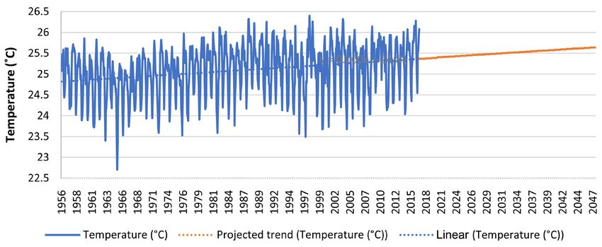
N. Sapala et al.

                                 Most people in PNG are subsistence agriculturalists; they grow crops (or
                              gather them from the forest) like tubers, fruits and nuts. The majority of the
                              cropping is from fallow systems. Fallow systems involve clearing and cutting
                              forest, some burning of felled vegetation, cultivation of crops for a number of
                              years (3 - 5 years in the lowlands to continuous in the highlands) and then ab-
                              andon the site to the natural process of regeneration (OCCD, 2014).
                                 Agriculture has been the economic backbone of PNG and will continue to be
                              so for a long time. PNG exports coffee, cocoa, copra, sugar, vanilla, and tea.
                              Agricultural growth however has been only around 1% the past decade (OCCD,
                              2014). With a population growth of around 2.7%, it is clear that many rural fam-
                              ilies have had a negative income growth. Because of higher prices on the inter-
                              national markets for agricultural commodities the situation has improved a little
                              recently (OCCD, 2014).

                              2.2. Data Source
                              Meteorological data of all weather stations in Papua New Guinea from 1956 to
                              2016 were obtained from the World Bank Climate Change Office in Washington
                              D.C., United States. Monthly average rainfall and monthly temperature data
                              were provided for the years 1956 to 2016. Data for 2017 to 2020 were unavailable
                              for this work, because they were not provided, as those were not approved for
                              the public to use. Those data will be available in September, 2021. All monthly
                              data from January 1956 to December 2016 were provided, so there were no
                              missing data in between. As such, no estimations were made to come up with
                              any monthly data for the years 60 years, 1956 to 2016.

                              2.3. Research Method
                              Monthly average rainfall data for the twelve months were added then divided by
                              twelve to come up with the average yearly rainfall for the country. The same was
                              done for temperature, monthly average temperature data for the twelve months
                              were added then divided by twelve to come up with the average yearly tempera-
                              ture for the country.
                                 Excel spread sheet was used for the calculation of the yearly average rainfalls
                              and temperatures, as this is an effective way to do calculations where minimal or
                              no errors can be made in the calculations. Since the increase and decrease in
                              both the yearly rainfalls and temperatures were the important elements to ob-
                              serve, linear forecast was used to observe the increasing trends. The linear fore-
                              cast was made using excel spread sheet also because, as in the calculations, it is
                              effective and errors can be minimal or none.
                                 To estimate the rainfall and temperature for the next thirty years (2016-2047),
                              the linear function y = a + bx model was used. This model is an effective model
                              used in many works to estimate future trendlines. This model was also used to
                              determine linear regression trend and 5-year moving average line to the seasonal
                              and annual rainfall data series for Lake Tana basin (LTB) area in Ethiopia (Wel-
                              degerima et al., 2018). Papua New Guinea used this model to estimate its car-

DOI: 10.4236/gep.2021.96004                        69            Journal of Geoscience and Environment Protection
N. Sapala et al.
bon-dioxide emission trendline for 2014-2018 in its forest reference level (FRL)
to the United Nations Framework Convention on Climate Change (CCDA,
2017). (Panda & Sahu, 2019) used this model to determine the trend of seasonal
minimum temperature from 1980 to 2017. For this work, first of all, the slope
and the intercept were calculated. To calculate the slope and the intercept, the
following equations were used.
Equation I is the main equation used for the calculation of the projected data.
Equation II and III are used to determine “b” and “a” respectively in Equation I.
Equations IV, V, and VI are used to determine the values in Equation III. With
the results of slope and intercept on hand, each was substituted for “b” and “a”
respectively, while the already available monthly rainfall/temperature data were
substituted for x.
Projected Rainfall (PR)
y = a + bx
PR = intercept + slope × rainfall data
Projected Temperature (PT)
y = a + bx
PT = intercept + slope × temperature data
The data used were monthly average rainfall and monthly average tempera-
ture. Using the monthly average temperature and monthly average rainfall, the
yearly average rainfall and yearly average temperature were calculated. To calcu-
late the yearly average rainfall and yearly average temperature, the arithmetic
average methodology was used. The methodology is shown below.
x1 + x2 + x3 + x4 + x5 + x6 + + xn ∑ i =1 xi
n
Arithmetic mean ( x )
= =
n n
Equation VII Arithmetic Average Methodology for projected rainfall and
temperate data calculation
The yearly average rainfall and temperature results were used to observe the
annual changes in rainfall and temperature and their trends after the calcula-
tions were made. Trendlines were also drawn using the calculated data as histor-
ical data.
3. Results
3.1. Analysis of Rainfall and Its Trendline
3.1.1. Analysis of Monthly Rainfall for the Initial and the Final Year
The average monthly rainfall for the initial year (1956) and the final year (2016)
were selected to display to observe the difference in the amount of rainfall re-
ceived and rainfall pattern in each of the months in the two years, after 60 years
apart. Table 1 below shows the values and Figure 2 presents two graphs (“a”
and “b”) representing the two years.
Table 1 shows the recorded monthly rainfall for the initial year (1956) and the
final year (2016) considered for this study. The two years were selected to ob-
serve the difference in the amount of rain received in each of the months after 60
years apart, before looking into the other years that are in between them.
DOI: 10.4236/gep.2021.96004 70 Journal of Geoscience and Environment Protection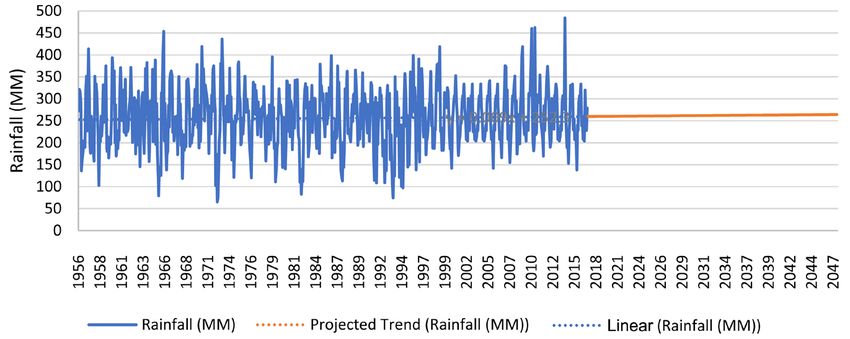
N. Sapala et al.

                                                                          (a)

                                                                          (b)

                              Figure 2. Above shows the monthly rainfall for Papua New Guinea for (a) 1956 initial
                              year considered and (b) 2016, the final year considered for this research.

                              Table 1. Monthly rainfall statistics for the year 1956 and 2016.

                                          Months                  Rainfall (mm), 1956            Rainfall (mm), 2016

                                            Jan                          272.255                       307.243

                                            Feb                          321.284                       305.243

                                            Mar                          315.291                       333.609

                                            Apr                          290.636                       238.417

                                           May                           136.472                       254.757

                                            Jun                          163.996                       207.825

                                            Jul                          179.753                       207.551

                                            Aug                          204.26                        203.823

                                            Sep                          200.765                       320.095

                                            Oct                          189.765                       239.805

                                            Nov                          315.069                       228.207

                                            Dec                          351.188                       278.85

                                The lowest amount of monthly rainfall received in 1956 was 136.472 mm in
                              the month of May, and the highest was 351.188 mm in the month of December.
                              While in 2016, the lowest amount of monthly rainfall is 203.823 mm in the

DOI: 10.4236/gep.2021.96004                           71              Journal of Geoscience and Environment Protection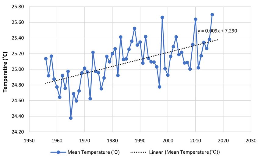
N. Sapala et al.

                              month of August and the highest rainfall was 333.609 mm in March. Looking at
                              the lowest and the highest monthly maximum rainfalls for the two years, lowest
                              monthly rainfall increased by 67.351 mm and the highest monthly rainfall de-
                              creased by 17.579 mm.
                                However, the annual total rainfall received in 1956 and 2016 are 245.061 mm
                              and 260.452 mm respectively as mentioned above. The numbers show that more
                              rainfall was received in 2016, so it is safe to conclude that there was an increase
                              in average yearly rainfall between 1956 and 2016. The numbers in Table 1 above
                              are represented in Figure 2. Figure 2 also shows the trend analysis in rainfall for
                              the two different years.
                                The dotted lines in both graph (a) and (b) show linear trendline for each of
                              the two years. With a trendline equation of y = −1.037x + 251.8 for 1956 and y =
                              −4.9194x + 292.43 for 2016, both show a declining trendline in rainfall from
                              January to December. Although both linear trendlines are decreasing, the linear
                              trendline for 2016 is steeper – which is going down compared to that of 1956.
                              This shows that higher amount of the total annual rainfall was received in the
                              first few months of the year in 2016 than in 1956. The blue dots in both graphs
                              in Figure 2 show the rainfall for each of the months for each of the two years. It
                              can be seen from the two graphs that the rainfall data for 1956 has a wider range
                              than that of 2016, where they are closer together. After 70 years, the clear change
                              observed is the increase in average monthly rainfall. In 1956, four months (May,
                              June, July and October) recorded monthly average rainfall below 200 mm; how-
                              ever, in 2016, none of them or the other eight months’ average rainfall data rec-
                              orded came below 200 mm with the month of May (which recorded the lowest
                              in 1956) recording the highest among the five months with 254.75 mm of rain.
                              This is a significant increase.
                                Although for 1956, the highest monthly average rainfall was above 350 mm,
                              while for 2016 it stays below 350 mm; the total amount of rainfall recorded in-
                              creased in 2016. The total amount of rainfall increased by 15.39 mm from 245.06
                              mm in 1956 to 260.45 mm in 2016. This is due to the increase in temperature
                              trend caused by climate change.

                              3.1.2. Analysis of Annual Rainfall Trend for All Years (1956-2016)
                              The precipitation data provided by World Bank consisted of monthly rainfall
                              data from January 1956 to December 2016. In order to come up with the average
                              annual rainfall for each of the 60 years, 1956-2016, the monthly rainfalls were
                              summed up and the total divided by twelve (representing twelve sets of data for
                              the 12 months). All the units are in millimeters. The methodology used was
                              Arithmetic Average Methodology shown in Table 2 below.
                                Used the above methodology, the average annual rainfall was calculated. Ta-
                              ble 3 below shows the results, average annual rainfall, calculated using the above
                              methodology. It also shows the minimum and the maximum rainfall in millime-
                              ters observed for each year in the 60 years, 1956-2016.

DOI: 10.4236/gep.2021.96004                         72            Journal of Geoscience and Environment Protection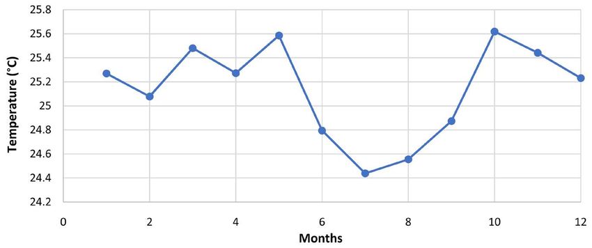
N. Sapala et al.
Table 2. Arithmetic Average Methodology converted in order to calculate the annual average rainfall or precipitation (P).
∑
n
x1 + x2 + x3 + x4 + x5 + x6 + + xn xi
Arithmetic mean ( x ) = = i =1
n n
∑
n
P1 + P2 + P3 + P4 + P5 + P6 + + Pn Pi
Pav = = i =1
n n
P1 + P2 + P3 + P4 + P5 + P6 + P7 + P8 + P9 + P10 + P11 + P12
Pav =
12
Table 3. Descriptive rainfall statistics for the years 1956-2016.
Year Mean Minimum Maximum Year Mean Minimum Maximum Year Mean Minimum Maximum
1956 245.06 136.47 351.19 1976 243.54 119.79 337.48 1996 278.82 138.24 398.96
1957 256.42 158.08 413.65 1977 271.64 213.89 332.08 1997 252.24 172.36 368.83
1958 243.08 102.72 334.09 1978 253.10 158.26 327.88 1998 268.57 186.87 377.88
1959 234.32 165.23 374.91 1979 221.80 111.09 395.10 1999 274.88 182.86 418.80
1960 271.03 170.02 393.48 1980 240.94 140.16 340.74 2000 250.17 141.92 325.56
1961 272.20 216.85 370.95 1981 268.23 184.37 342.18 2001 258.87 170.82 352.81
1962 268.49 174.43 371.72 1982 201.89 82.75 343.39 2002 263.42 203.82 333.61
1963 235.06 145.33 317.53 1983 273.89 167.80 334.67 2003 251.50 203.82 333.61
1964 273.34 157.35 382.23 1984 253.62 175.54 379.11 2004 256.18 203.82 333.61
1965 219.27 79.42 388.01 1985 278.95 213.49 329.46 2005 255.32 142.15 341.30
1966 268.52 138.21 453.26 1986 248.17 165.43 398.32 2006 251.98 165.74 333.61
1967 264.49 172.68 363.09 1987 223.63 112.91 374.83 2007 265.49 155.02 375.12
1968 232.71 118.47 350.52 1988 266.14 202.05 362.54 2008 265.05 174.25 351.64
1969 262.85 191.72 345.35 1989 265.76 194.16 365.42 2009 275.56 203.82 418.85
1970 293.40 188.40 419.12 1990 266.07 191.38 359.25 2010 297.76 181.87 461.59
1971 280.67 175.70 334.14 1991 240.23 108.17 336.79 2011 263.47 170.02 354.29
1972 212.78 65.16 374.90 1992 227.83 109.13 324.48 2012 274.63 189.96 373.84
1973 297.41 177.06 435.92 1993 203.56 74.11 349.63 2013 259.63 203.82 333.61
1974 243.77 120.97 369.68 1994 202.31 97.45 316.28 2014 267.24 152.87 484.31
1975 284.51 195.82 383.66 1995 255.87 144.73 361.30 2015 245.64 137.87 333.61
2016 260.45 203.82 333.61
The average yearly rainfall, together with the minimum and maximum rainfall
for the years 1956-2016, displayed in Table 3 reveals that all yearly rainfall data
fell within the range, 200 mm and 300 mm. The average annual rainfall statistics
given in Table 3 above are presented on the graph in Figure 3. The graph also
shows the trend of rainfall in Papua New Guinea in the 60 years.
The trendline represented by the dotted black straight line is an increasing
trend. The blue dots presentation the yearly average rainfall for each year and
DOI: 10.4236/gep.2021.96004 73 Journal of Geoscience and Environment Protection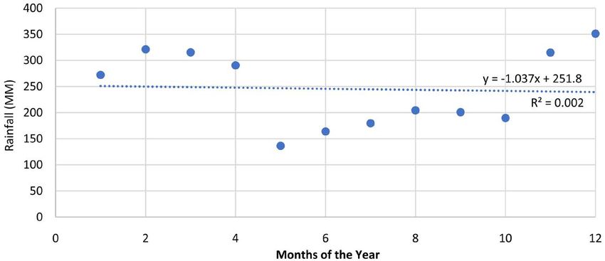
N. Sapala et al.

                              Figure 3. Rainfall trend for Papua New Guinea for the years 1956-2016.

                              the bold blue line represents the increase and decrease in rainfall from one year
                              to the other. According to the graph above, the highest annual average rainfall
                              was recorded in 2010 with 297.76 mm, and the lowest annual average rainfall
                              was recorded in 1982 with 201.89 mm.

                              3.2. Analysis of Temperature and It’s Trendline
                              3.2.1. Analysis of Monthly Temperature for the Initial and the Final Year
                              The average monthly temperature for the initial year (1956) and the final year
                              year (2016) were selected to display to observe the difference in the temperature
                              reading and the difference in temperature pattern in each of the months in the
                              two years, after 60 years apart. Table 4 below shows the values and the subse-
                              quent Figure 4 presents two graphs (“a” and “b”) representing the two years.
                                 Table 4 shows the recorded monthly temperature for the initial year (1956)
                              and the final year (2016) considered for this study. The two years were selected
                              to observe the difference in the temperature reading in each of the months after
                              60 years apart, before looking into the other years that are in between them.
                                 The average monthly temperature for the initial year (1956) and the final year
                              year (2016) were selected to display among other years to see how temperature
                              changed in each of the months after 70 years. Figure 4 below presents two
                              graphs (“a” and “b”) representing the two years.
                                 Figure 4 shows the average monthly temperature for Papua New Guinea for
                              the initial year and the final year considered for this study. The highest mean
                              temperature reached between 1956 and 2016 was 25.70˚C in 2016 while the low-
                              est mean temperature reached between the same period was 24.38˚C in 1965.
                              Generally, the mean temperature range is good. The average yearly temperature
                              range doesn’t go beyond 26˚C and doesn’t go below 24˚C.
                                 After 70 years, a clear change observed is the increase in average monthly
                              temperature. The highest monthly average temperature recorded in 1956 stands

DOI: 10.4236/gep.2021.96004                         74              Journal of Geoscience and Environment Protection
N. Sapala et al.

                                                                         (a)

                                                                         (b)

                              Figure 4. Average monthly temperature for Papua New Guinea (a) 1956 and (b) 2016.

                              Table 4. Monthly temperature statistics for the year 1956 and 2016.

                                         Months                  Rainfall (mm), 1956           Rainfall (mm), 2016

                                            Jan                         25.27                         25.81

                                           Feb                          25.08                         26.16

                                           Mar                          25.48                         26.00

                                           Apr                          25.27                         26.00

                                           May                          25.59                         26.28

                                           Jun                          24.79                         25.64

                                            Jul                         24.44                         24.95

                                           Aug                          24.56                         24.54

                                           Sep                          24.87                         25.52

                                           Oct                          25.62                         25.55

                                           Nov                          25.44                         25.86

                                           Dec                          25.23                         26.08

                              at 25.61 degrees celsius, while the highest monthly average temperature recorded
                              in 2016 stands at 26.28 degree celsius.

DOI: 10.4236/gep.2021.96004                          75              Journal of Geoscience and Environment Protection
N. Sapala et al.
3.2.2. Analysis of Annual Temperature Trend for All Years (1956-2016)
The temperature data provided by World Bank consisted of monthly rainfall da-
ta from January 1956 to December 2016. In order to come up with the average
annual temperature for each of the 60 years, 1956-2016, the monthly average
temperatures were summed up and the total divided by twelve (representing
twelve sets of data for the 12 months). All the units are in degree Celsius. The
methodology used is arithmetic average methodology, the same one used for the
calculation of trend for rainfall. The methodology is shown in Table 5 below.
Table 6 below shows the results, average annual temperature data, calculated
using the above methodology. The table also displays the minimum and the
maximum rainfall in degree Celsius recorded for each year, in 60 years, 1956-2016.
Table 5. Arithmetic average methodology converted in order to calculate the annual av-
erage temperature.
∑
n
x1 + x2 + x3 + x4 + x5 + x6 + + xn xi
Arithmetic mean ( x ) = = i =1
n n
∑
n
T1 + T2 + T3 + T4 + T5 + T6 + + Tn Ti
Tav = = i =1
n n
T1 + T2 + T3 + T4 + T5 + T6 + T7 + T8 + T9 + T10 + T11 + T12
Tav =
12
Table 6. Descriptive temperature statistics for the years 1956-2016.
Year Mean Minimum Maximum Year Mean Minimum Maximum Year Mean Minimum Maximum
1956 25.14 25.62 24.44 1976 24.75 25.97 23.53 1996 25.03 25.76 23.56
1957 24.92 25.61 24.16 1977 24.89 25.65 23.88 1997 24.77 25.84 23.49
1958 25.17 25.71 24.02 1978 25.17 25.68 24.51 1998 25.66 26.40 24.92
1959 24.87 25.86 23.89 1979 25.10 25.88 23.91 1999 25.01 25.60 23.99
1960 24.77 25.45 23.89 1980 25.20 25.88 24.16 2000 24.93 25.91 23.67
1961 24.64 25.51 23.72 1981 25.26 26.00 24.43 2001 25.16 26.12 23.73
1962 24.92 25.83 23.91 1982 24.92 26.12 23.59 2002 25.29 26.08 24.07
1963 24.76 25.64 23.40 1983 25.41 26.08 24.20 2003 25.41 26.32 24.20
1964 24.97 25.53 24.18 1984 25.13 26.02 23.93 2004 25.19 26.25 23.67
1965 24.38 25.25 22.70 1985 25.13 25.75 23.76 2005 25.22 26.06 23.93
1966 24.69 25.18 23.53 1986 25.26 25.92 24.39 2006 25.08 25.66 24.15
1967 24.60 25.43 23.74 1987 25.36 26.32 24.17 2007 25.09 25.84 23.75
1968 24.72 25.38 24.12 1988 25.52 26.22 24.65 2008 25.00 26.14 24.03
1969 24.95 25.62 24.11 1989 25.31 25.80 24.64 2009 25.32 25.82 24.55
1970 25.01 25.49 23.93 1990 25.35 26.25 24.23 2010 25.64 25.98 24.86
1971 24.97 25.80 23.94 1991 25.08 25.98 24.28 2011 25.02 25.94 24.14
1972 24.62 25.54 23.59 1992 25.42 26.04 24.29 2012 25.17 25.93 24.30
1973 25.22 25.82 24.15 1993 25.14 25.86 24.13 2013 25.34 25.90 24.38
1974 24.97 25.65 23.86 1994 25.10 26.05 24.11 2014 25.27 26.08 24.04
1975 24.96 25.40 24.16 1995 25.09 26.15 24.03 2015 25.38 25.81 24.35
2016 25.70 26.28 24.54
DOI: 10.4236/gep.2021.96004 76 Journal of Geoscience and Environment ProtectionN. Sapala et al.
The annual average temperature statistics together with the minimum and
maximum temperature for the years 1956-2016, displayed in Table 6 reveals that
all annual rainfall data fall within the range, 24.0 degree Celsius and 26.000 de-
gree Celsius. The average annual mean temperature statistics given in Table 6
above are presented on the graph in Figure 5. The graph also shows the trend of
temperature in Papua New Guinea in the 60 years.
The annual temperature trendline is represented by the dotted black straight
line. The blue dots represent the annual average temperature for each year. And
the bold blue line represents the increase and decrease in annual average tem-
perature from one year to the other in the sixty years. According to the graph
above, the highest annual average temperature was recorded in 2016 with 25.70
degrees, and the lowest annual average temperature was 24.34 degrees recorded
in 1965.
A research found that there were increased temperatures in the Tropical Pa-
cific Region, region where Papua New Guinea is located. Correlations between
mean temperature and the frequency of extreme temperatures were strongest in
the tropical Pacific Ocean from French Polynesia to Papua New Guinea, Malay-
sia, the Philippines, Thailand and southern Japan (Griffiths et al., 2005). Ob-
viously, the increase in the trend of rainfall in Papua New Guinea is a result of
the increase in temperature. The results in this work with an increased trend in
both rainfall and temperature coincide well with the above research.
3.3. Projection of Rainfall and Temperature 2017-2047
Apart from the annual average rainfall and temperature trend observations for
the sixty years, the monthly average rainfall and monthly average temperature
trend observation were also done. These gave reflection of how the two recorded
parameters looked like when each one of them increased or decreased from one
month to another in each year from January 1956 to December 2016. The
Figure 5. Temperature trend for Papua New Guinea, 1956-2016.
DOI: 10.4236/gep.2021.96004 77 Journal of Geoscience and Environment ProtectionN. Sapala et al.
projection of rainfall and temperature for the next 30 years was made using
monthly average rainfall data. The projections rainfall and temperature and are
shown in Figure 7 and Figure 9 respectively.
3.3.1. Rainfall Projection
The monthly average rainfall trend observed for 1956 to 2016 is shown in Figure
6.
Figure 6 shows the monthly rainfall pattern for Papua New Guinea. From
Figure 6, it can be seen that there is an increasing trend in rainfall in the sixty
years. The equation extracted from the above trendline is; y = 0.0093x + 252.38.
Using this equation, a project of 30 years was made. Thirty years were decided
because sixty years of data is sufficient to predict and project the period’s rainfall
trendline. To come up with the projected temperature for each of the months in
those 30 years, Equation I (“y = a + bx”) in Table 7 was been used. Following
data are substituted into the above equation I:
Projected Rainfall (PR)
y = a + bx
PT = intercept + slope × rainfall data
PT = 7.29040829 + 0.008962781 (monthly rainfall data)
After the projected rainfall for 2017-2047 were calculated, projections were
made. The projected monthly average rainfall for Papua New Guinea is shown in
Figure 7.
Figure 7 shows 60 years of monthly rainfall in millimeters recorded in Papua
New Guinea from January 1956 to December 2016. The bold blue line shows the
Table 7. Equations used in the rainfall and temperature projections.
Projection (y) = a + bx
Equation I To calculate Projected rainfall/temperature
Slope= y − bx
Equation II To calculate Slope (b) of regression line
Sy
Y =r
Sx
Equation III To calculate Y-Intercept (a) of regression line Intercept
r=
∑ ( ( x − x )( y − y ) )
∑(x − x ) ∑( y − y )
2 2
Equation IV To calculate Correlation Coefficient (Pearson’s r)
∑( y − y )
2
Sy =
n −1
Equation V To calculate Standard Deviation of y (Sy)
∑(x − x )
2
Sx =
n −1
Equation VI To calculate Standard Deviation of x (Sx)
DOI: 10.4236/gep.2021.96004 78 Journal of Geoscience and Environment ProtectionN. Sapala et al.
Figure 6. Monthly average rainfall (MM) for Papua New Guinea from January,
1956-December, 2016.
Figure 7. Showing projected trend for average monthly rainfall (in red) for Papua New
Guinea, 2017-2047.
increase and decrease in rainfall. It reveals that Papua New Guinea recorded the
lowest average monthly rainfall of 65.1629 mm on the month of August in 1972.
The country’s highest amount of monthly rainfall of 484.306 mm was recorded
on the month of April in 2014.
The dotted blue linear trendline shows the increasing trend in rainfall in the
60 years. The bold red line towards the end projects trendline from January 2017
to December 2047. The projection shows and increases in rainfall for the country.
3.3.2. Temperature Projection
The monthly average temperature trend observed for 1956 to 2016 is shown in
Figure 8.
Figure 8 shows the monthly average temperature pattern for Papua New
Guinea. It is seen that there is an increasing trend in temperature in the sixty
years. The equation extracted from the trendline above is; y = 0.0007x + 24.818.
Using this equation, a project of 30 years was made.
DOI: 10.4236/gep.2021.96004 79 Journal of Geoscience and Environment ProtectionN. Sapala et al.
Figure 8. Monthly average temperature (˚C) for Papua New Guinea from January,
1956-December, 2016.
Thirty years were decided because sixty years of data is sufficient to predict
and project the period’s temperature trendline. To come up with the projected
temperature for each of the months in those 30 years Equation I (“y = a + bx”) in
Table 7 has been used. Following data are substituted into the above equation I:
Projected Temperature (PT)
y = a + bx
PT = intercept + slope × temperature data
PT = 7.29040829 + 0.008962781 (temperature data)
After the projected rainfall for 2017-2047 were calculated, projections were
made. The projection for monthly average temperature for Papua New Guinea is
shown in Figure 9.
Figure 9 shows the 60-year monthly temperature change for Papua New
Guinea between January 1956 to December 2016 and the projection between
2017-2047. The increase and decrease are shown by bold blue line. It reveals that
Papua New Guinea recorded the lowest monthly average temperature of
22.7034˚C on the month of July in 1965. The country recorded the highest
monthly average temperature of 26.399˚C on the month of April in 1998.
The thin straight dotted blue linear trendline shows the increasing trend in
temperature in the 60 years. The bold red linear trendline shows the projection
in temperature from January 2017 to December 2047. The projection reveals an
increase in temperature in the next 30 years for the country. Generally, Papua
New Guinea is already warm, being located in the tropics, just 6 degrees south of
the equator (Tsuchiya, 1991) (Kawabe, Kashino, & Kuroda, 2008). It has only
two seasons, wet and dry, and so, it does not experience summer or winter. Al-
though the seasons may not change to summer or winter because of the coun-
try’s position, near the equator, extreme changes in temperatures may affect
plants and animals including human beings. An increase in temperature, rain-
fall, and humidity may cause a proliferation of the malaria-carrying mosquitoes
at higher altitudes, resulting in an increase in malaria transmission (Fernando,
DOI: 10.4236/gep.2021.96004 80 Journal of Geoscience and Environment ProtectionN. Sapala et al.
2020).
Figure 9. Showing projected trend for average monthly temperature (in red) for Papua
New Guinea 2017-2047.
According to Figure 8 and Figure 9, Papua New Guinea recorded very low
temperature in 1792 and 1997. This correlated well with events in the country
where the Highlands region was extremely affected by drought in 1972 and 1997
(Barr, 2019; Tadesse, Brown, & Hayes, 2005; White & Walcott, 2009). Research-
ers have found that there is correlation between rainfall and temperature. The
spatial pattern of surface air temperature change is correlated to the changes in
moderate precipitation (Yu & Li, 2012). The increased trend in both of the pa-
rament agrees with this.
4. Discussion
Over the period of study period 1956 to 2016, the study found that the climatic
factors, rainfall, and temperature pattern in Papua New Guinea has been chang-
ing. The general linear model analysis was used to investigate the trend in both
rainfall and temperature and to predict the future trends. It was found that there
is an increasing trend in rainfall and temperature (Figure 6 and Figure 8). Pro-
jections (Figure 7 and Figure 9) reveal a future increase in rainfall and temper-
ature into the future. The critical impact areas of increase in precipitation, high
temperature, and rise in sea level are on terrestrial and aquatic resources, civic
infrastructure, population and agriculture (Michael, 2019).
Rainfall in Papua New Guinea is increasing in April, May June and July;
which were the months with lowest rainfall. And the month of September, Oc-
tober, November and December which experiences the highest rainfall in the
1950s is now experiencing a decline. For examples, in 1956 the month of De-
cember received 351.19 mm, but received 278.85 mm in 2016. This amount
(278.85 mm) of rainfall received in December 2016 is lower than the amount re-
ceived in January, February, March, and September; months which received
lower rainfall than December did in 1956. The highest rainy month is where the
rain intensity is high and flooding could result. The projection of rainfall for
Papua New Guinea revealed that rainfall was trending upward with a linear
model equation: Rainfall = 0.0093x + 252.38. The increased trend in rainfall
suggests that there is an increase in evaporation and transpiration taking place.
DOI: 10.4236/gep.2021.96004 81 Journal of Geoscience and Environment ProtectionN. Sapala et al.
Factors such as temperature, humidity, evaporation, and vegetation contribute
to the amount of rainfall recorded in a locality (Issahaku, Campion, & Edziyie,
2016). Therefore, as long as temperature change continues to take place, they’ll
be a change in rainfall in Papua New Guinea.
There is change in temperature in Papua New Guinea. Although it does not
come down to zero or go up to 40 or 50 as in other countries, the change is clear
in the analysis made in this study There is an increasing trend in temperature for
the country. The highly non-linear nature of the relationship between changes in
mean temperature and the corresponding changes in extreme temperature
events is well known, relatively small alterations in the mean state can result in a
large change in the probabilities of extreme events (Griffiths et al., 2005). In this
study, there is an increasing trend in temperature (see Figure 8). Also, it is clear
from the projected trendline (Figure 9) that temperatures in Papua New Guinea
would continue to increase into the future.
There is a huge amount of logging going on in Papua New Guinea that is de-
creasing the number of trees (CCDA, 2017). As trees are decreased, CO2 will
continue to increase which will continue to increase the temperature. As a result,
carbon absorption is decreasing and carbon emission is increasing (CCDA,
2018). This would continue to increase, as emissions of carbon-dioxide into the
air has a direct relationship with the increase in temperature (Legates, 2012).
If this increasing trend in the two parameters continues, a lot is at risk for
Papua New Guinea. The country is home to the third largest tropical rainforest
in the world (CCDA, 2014). It has the 6% of the world’s biodiversity on less than
1% of the land (OCCD, 2015). Also, the country is part of the Coral Triangle
which has more coral reef fish diversity than anywhere else in the world: 37%
(2228) of the world’s coral reef fish species (6000), and 56% of the coral reef
fishes in the Indo-Pacific region (4050). 8% (235 species) of the coral reef fishes
in the Coral Triangle are endemic or locally restricted species (WWF, 2015)
(Drew, Amatangelo, & Hufbauer, 2015). To save these and other organisms
which depend on the land and seas in Papua New Guinea, the current increased
trend in rainfall and temperature needs to be addressed to decrease or stabilize
the parameters.
5. Conclusion
In this study, the assessment of trend and variations in rainfall and temperature
in Papua New Guinea between 1956 and 2016 (60 years) was done. Also, projec-
tion of the trends from 2017 to 2047 (30 years) was done. In sixty years, the
trend in rainfall and temperature increased for the country. This shows that
there has been a change in the climatic condition for Papua New Guinea where
the place was getting warmer due to the increasing in temperature. The projec-
tions (see Figure 7 and Figure 9) showed an increasing trend in the monthly
average rainfall and temperature from January 2017 to December 1947. The two
parameters, rainfall and temperature, are projected to increase with a linear re-
gression functions of y = 0.0093x + 252.38 and y = 0.0007x + 24.818 respectively.
DOI: 10.4236/gep.2021.96004 82 Journal of Geoscience and Environment ProtectionN. Sapala et al.
If nothing is done to combat the current rate of climatic changes experienced in
the country, the increasing trend in rainfall and temperature would continue.
The increase in temperature and rainfall is not healthy for both plants and
animals including humans. This would introduce new diseases. An increase in
temperature, rainfall, and humidity may cause a proliferation of the mala-
ria-carrying mosquitoes at higher altitudes, resulting in an increase in malaria
transmission. Plants and animals which live in both the sea and on land which
cannot adapt to changes could eventually be at the risk of dying out. It is clear
that the increasing trends in both rainfall and temperature would not see any
decrease in the near future unless something is done. And, this calls for imme-
diate actions as the issue needs to be addressed in time. Therefore, it is recom-
mended that the government of Papua New Guinea consider incorporating cli-
mate change policies into their development plans.
Acknowledgements
The authors of this paper wish to thank the World Bank, Washington DC, for
making rainfall and temperature data available to us for use. A special thanks to
Emmanuel B. Greene for making this possible.
Conflicts of Interest
The authors declare no conflicts of interest regarding the publication of this pa-
per.
References
Barr, J. (2019). Reducing the Impact of Environmental Emergencies through Early
Warning and Preparedness. Tokyo.
Cámara-Leret, R., Raes, N., Roehrdanz, P., de Fretes, Y., Heatubun, C. D., Roeble, L.,
Schuiteman, A., van Welzen, P. C., & Hannah, L. (2019). Climate Change Threatens New
Guinea’s Biocultural Heritage. Science Advances, 5, eaaz1455.
https://doi.org/10.1126/sciadv.aaz1455
CCDA (2014). National Climate Compatible Development Management Policy. Papua
New Guinea.
CCDA (2017). Papua New Guinea’s National REDD+ Forest Reference Level. Port Mo-
resby.
CCDA (2018). Papua New Guinea’s First Biennial Update Report to the United Nations
Framework Convention on Climate Change. Port Moresby: Climate Change and De-
velopment Authority.
CSIRO (2015). Australian National Outlook 2015.
Drew, J. A., Amatangelo, K. L., & Hufbauer, R. A. (2015). Quantifying the Human Im-
pacts on Papua New Guinea Reef Fish Communities across Space and Time. PLoS
ONE, 10, e0140682. https://doi.org/10.1371/journal.pone.0140682
Fernando, S. D. (2020). Climate Change and Malaria—A Complex Relationship. United
Nations.
Griffiths, G. M., Chambers, L. E., Haylock, M. R., Manton, M. J., Nicholls, N., Baek, H. J.,
Choi, Y., Della-Marta, P. M., Gosai, A., Iga, N., Lata, R., Laurent, V., Maitrepierre, L.,
DOI: 10.4236/gep.2021.96004 83 Journal of Geoscience and Environment ProtectionN. Sapala et al.
Nakamigawa, H., Ouprasitwong, N., Solofa, D., Tahani, L., Thuy, D. T., Tibig, L., Tre-
win, B., Vediapan, K., & Zhai, P. (2005). Change in Mean Temperature as a Predictor
of Extreme Temperature Change in the Asia-Pacific Region. International Journal of
Climatology, 25, 1301-1330. https://doi.org/10.1002/joc.1194
IOM (2008). Migration and Climate Change. Geneva.
Issahaku, A.-R., Campion, B. B., & Edziyie, R. (2016). Rainfall and Temperature Changes
and Variability in the Upper East Region of Ghana. Earth and Space Science, 3,
284-294. https://doi.org/10.1002/2016EA000161
Kaluwin, C., Inape, K., & Virobo, M. (2016). Chapter 11 Papua New Guinea. In Climate
Change in the Pacific: Scientific Assessment and New Research. Volume 2: Country
Reports. Chapter 11: Papua New Guinea (pp. 169-184). Canberra: National Library of
Australia.
Kawabe, M., Kashino, Y., & Kuroda, Y. (2008). Variability and Linkages of New Guinea
Coastal Undercurrent and Lower Equatorial Intermediate Current. Journal of Physical
Oceanography, 38, 1780-1793.
Legates, D. (2012). Carbon Dioxide and Air Temperature: Who Leads and Who Follows?
(pp. 1-9).
Mann, T., & Westphal, H. (2016). Multi-Decadal Shoreline Changes on Takú Atoll, Papua
New Guinea: Observational Evidence of Early Reef Island Recovery after the Impact of
Storm Waves. Geomorphology, 257, 75-84.
https://doi.org/10.1016/j.geomorph.2015.12.028
Michael, P. S. (2019). Current Evidence and Future Projections: A Comparative Analysis
of the Impacts of Climate Change on Critical Climate-Sensitive Areas of Papua New
Guinea. SAINS TANAH—Journal of Soil Science and Agroclimatology, 16, 229.
https://doi.org/10.20961/stjssa.v16i2.35712
OCCD (2014). Papua New Guinea Second National Communication to the United Na-
tions Framework Convention on Climate Change. Port Moresby.
OCCD (2015). Intended Nationally Determined Contribution (INDC) under the United
Nations Framework Convention on Climate Change. Port Moresby.
Panda, A., & Sahu, N. (2019). Trend Analysis of Seasonal Rainfall and Temperature Pat-
tern in Kalahandi, Bolangir and Koraput Districts of Odisha, India. Atmospheric
Science Letters, 20, e932. https://doi.org/10.1002/asl.932
Seth, W. (2013). Increases in Rainfall Extremes Linked to Global Warming. The Conver-
sation.
Sungkuk, K., & Ibrahim, A. (2015). Climate Change in Papua New Guinea. United Na-
tions Education Science and Cultural Organisation.
http://www.climatefrontlines.org/blog/climate-change-papua-new-guinea
Tadesse, T., Brown, J. F., & Hayes, M. J. (2005). A New Approach for Predicting
Drought-Related Vegetation Stress: Integrating Satellite, Climate, and Biophysical Data
over the U.S. Central Plains. ISPRS Journal of Photogrammetry and Remote Sensing,
59, 244-253. https://doi.org/10.1016/j.isprsjprs.2005.02.003
Tsuchiya, M. (1991). Flow Path of the Antarctic Intermediate Water in the Western
Equatorial South Pacific Ocean. Deep Sea Research Part A. Oceanographic Research
Papers, 38, S273-S279. https://doi.org/10.1016/S0198-0149(12)80013-6
Weldegerima, T. M., Zeleke, T. T., Birhanu, B. S., Zaitchik, B. F., & Fetene, Z. A. (2018).
Analysis of Rainfall Trends and Its Relationship with SST Signals in the Lake Tana Ba-
sin, Ethiopia. Advances in Meteorology, 2018, Article ID: 5869010.
https://doi.org/10.1155/2018/5869010
DOI: 10.4236/gep.2021.96004 84 Journal of Geoscience and Environment ProtectionN. Sapala et al.
White, D. H., & Walcott, J. J. (2009). The Role of Seasonal Indices in Monitoring and As-
sessing Agricultural and Other Droughts: A Review. Crop and Pasture Science, 60,
599-616. https://doi.org/10.1071/CP08378
WHO (2015). WHO Calls for Urgent Action to Protect Health from Climate Change—Sign
the Call. WHO Climate Ch.
https://www.who.int/news/item/06-10-2015-who-calls-for-urgent-action-to-protect-he
alth-from-climate-change-sign-the-call
WWF (2015). Coral Triangle Facts. WWF Global.
Yu, R. C., & Li, J. (2012). Hourly Rainfall Changes in Response to Surface Air Tempera-
ture over Eastern Contiguous China. Journal of Climate, 25, 6851-6861.
DOI: 10.4236/gep.2021.96004 85 Journal of Geoscience and Environment ProtectionYou can also read