Staffordshire County Council LCWIP - Lichfield Cycle Audit - The first point to make is to say that the I ...
←
→
Page content transcription
If your browser does not render page correctly, please read the page content below
Staffordshire County Council
LCWIP – Lichfield Cycle Audit

October 2019
About Sustrans
Sustrans makes smarter travel choices possible, desirable and inevitable. We’re a
leading UK charity enabling people to travel by foot, bike or public transport for more
of the journeys we make every day. We work with families, communities, policy-
makers and partner organisations so that people are able to choose healthier,
cleaner and cheaper journeys, with better places and spaces to move through and
live in.
It’s time we all began making smarter travel choices. Make your move and support
Sustrans today. www.sustrans.org.uk

Head Office
Sustrans
2 Cathedral Square
College Green
Bristol
BS1 5DD
© Sustrans 2019
Registered Charity No. 326550 (England and Wales) SC039263 (Scotland)
VAT Registration No. 416740656

Document History:

  Report number:

  Revision number:                                 2.0

  Propose of issue:                               Final

  Date Issued:                             November 2019

  Author:                                   Edward Healey

  Checked by:

                                                          2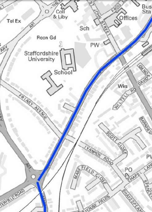
1. Burton Road (A5127)
2. Burton Old Road
3. Rotten Row/Sturgeon Hill/Boley Lane
4. Broad Lane
5. Quarry Hills Lane
6. Tamworth Road (A51)
7. Birmingham Road (south)
8. Friary Road
9. Christchurch Lane
10. Birmingham Road
11. Grange Lane
12. Weston Road
13. Eastern Avenue
14. Dimbles Road/Weston Road
15. Watery Lane
16. Eastern Avenue
17. Curborough Road / St Chad’s Road
18. Greenhill / George Lane
19. St Chad’s Road

                              3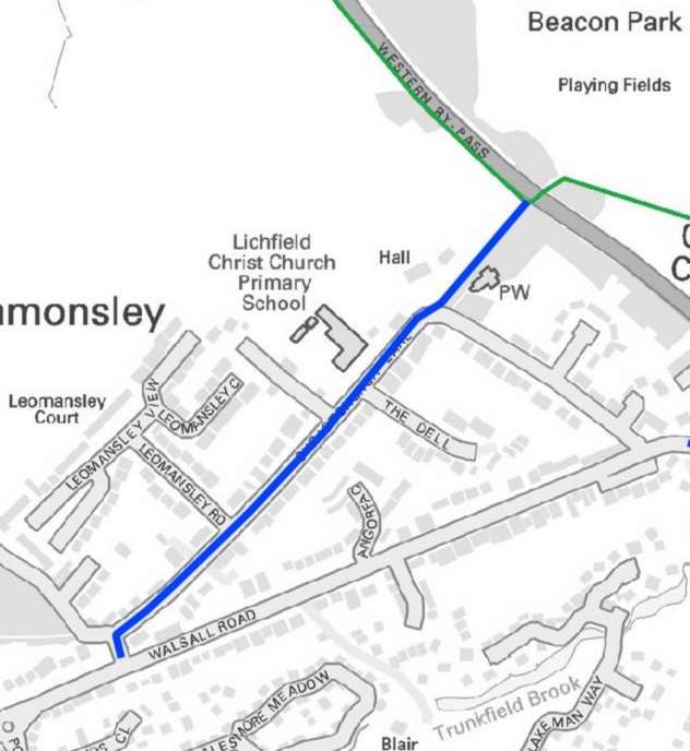
1      Route Audit

    Location /   Location    Comments and                                                                Photographs
    Section to   reference   recommendations
                  number
Burton Road          1       A busy route into the city from
                             Streethay and Burton.

                             Shared use cycle provision
                             exists on the southern side of
                             the carriageway from Lichfield
                             Trent Valley Station to the new
                             development at Oak Way,
                             however the signalised crossing
                             facility does not provide a
                             cycling phase nor is there
                             shared use footway to access
                             the housing. There is no cycling
                             provision at the signalised
                             junction either.

                             After Oak Way Burton Road
                             becomes very narrow with no
                             opportunity to provide a safe off-
                             road cycle facility.

                             It is proposed that an alternative
                             route be used through the new
                             housing estate with improved
                             crossing facility at the existing
                             crossing and associated shared
                             use footway upgrade.

                             (1 no. toucan crossing)

                             (180m new shared use footway)

                                                                  Existing crossing on Burton Road

                                                                                                     4
Existing crossing on Burton Road

Signalised junction at Oak Way

                                   5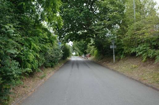
Burton Road beyond Oak Way

Burton Old Road   2   A residential road that is closed
                      at the railway crossing.

                      An at grade level crossing for
                      pedestrians and dismounted
                      cyclists enables through access
                      to Burton Old Road East.

                      The route was well used at the
                      time of survey and it is formed
                      of a closed highway crossing.

                      Limited opportunity to improve
                      the existing access
                      arrangements apart from
                      constructing a bridge at high
                      costs over the electrified
                      railway.

                      The residential road is quiet and
                      fit for cycling with no
                      intervention necessary.

                                                          Burton Old Road

                                                                                       6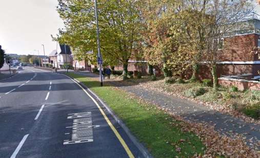
Access to railway crossing

At grade level crossing

                             7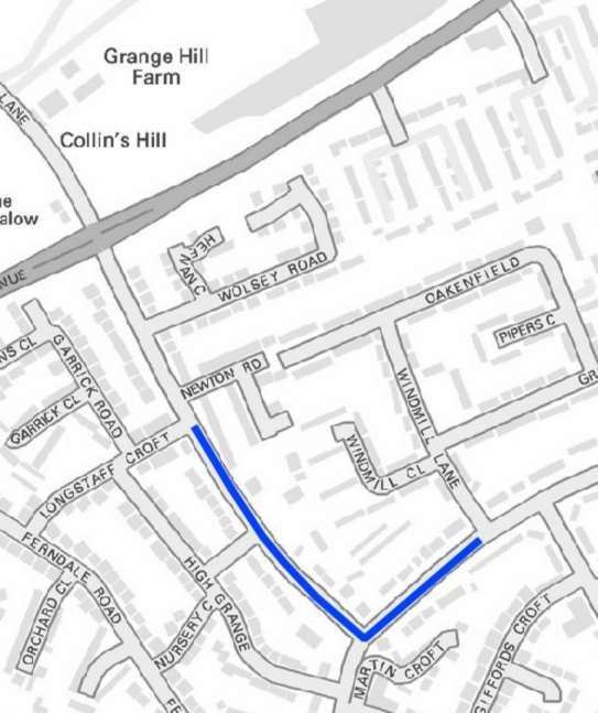
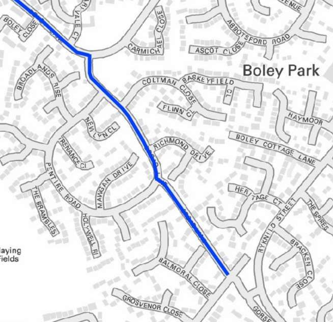
Rotten Row/      3   Rotten Row/ Sturgeon Hill/
Sturgeon Hill/       Boley Lane form a busy
Boley Lane           distributor road from the
                     residential areas on the south
                     east of Lichfield to access the
                     town centre and Birmingham
                     Road.

                     Traffic flows were relatively high
                     and speeds increased once
                     over the railway bridge and on
                     to Boley Lane.

                     Little opportunity exists within
                     the existing carriageway for
                     cycle facilities due to restricted
                     width.

                     Alternative options and routes
                     are also limited.

                     Recommend further
                     investigation of alternative
                     options and should none be
                                                          Rotten Row
                     available a quietway treatment
                     and speed reduction should be
                     considered.

                     (643m of quietway treatment)

                                                          Rotten Row

                                                                       8
Sturgeon’s Hill

Broad Lane   4   A quiet residential street that is
                 already traffic calmed with build-
                 outs.

                 No special treatments are
                 required apart from signage as
                 a recommended cycle route and
                 possibly quietway treatment.

                 (564m of quietway treatment)

                                                      Broad Lane

                                                                        9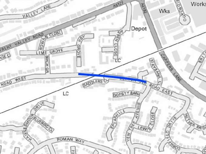
Junction with Quarry Hills Lane

Quarry Hills Lane   5   Predominantly a quiet
                        residential road with low speed
                        and volumes.

                        The carriageway narrows
                        considerably on approach to
                        Tamworth Road.

                        Previous investigation has been
                        made into making this section
                        one way and using filtered
                        permeability to provide cycle
                        contra-flow however these
                        proposals were not progressed.

                        Recommend further
                        investigation into how Tamworth
                        Road can be accessed.

                                                          Quarry Hills Lane

                                                                                            10
Approach to Tamworth Road
Cyclist on Quarry Hills Lane
11Junction with Tamworth Road
Tamworth Road 6 Tamworth Road is a heavily
trafficked and fast road that
requires off-road cycling
provision.
Footway only exists on one side
of the carriageway and this is of
limited width, which would
require widening to shared use
facility. Sufficient carriageway
space appears to exist to widen
into.
A service road that runs parallel
to Tamworth Road provides an
alternative quiet cycle option
and would reduce the amount of
new shared use construction.
Detail of the access/egress at
the Shortbutts Lane junction
would require further detail.
It is acknowledged that the
former canal runs on this Tamworth Road
alignment that would provide
similar facility however this
would require crossing and re-
crossing to access.
An alternative route to
investigate would be to access
St John’s Street via Borrowcop
Lane
Further investigation required of
the costs associated with all
three options.
12Recommend running all three
options through the Route
Selection Tool.
(164m new shared use footway/
cycleway)
Borrowcop Lane
Birmingham Road 7 Birmingham Road is a key route
(south) into the city centre from the
southern residential areas of
Lichfield.
No current provision exists for
cyclists and traffic speeds/
volumes are high.
Shared use off-road facility
would be required to encourage
modal shift and support existing
journeys.
Sufficient carriageway width
appears to be available to
construct new cycleway by
widening the footway into the
carriageway.
Recommend further engineering
feasibility study to identify
options and possibilities and/or
alternative route alignments that
may be available from new End of cycle route at Birmingham Road/ Falkland Road
developments.
(671m of new shared use
footway cycleway)
13Birmingham Road towards the city centre
Cycle provision at rail bridge
14Cycle provision at Birmingham Road/ The Friary
Friary Road 8 Friary Road already has cycle
provision which is adequate but
requires maintenance, nothing
further is required unless new
off-road provision was deemed
necessary to support new
housing growth to the south of
Lichfield.
Friary Road cycle provision
15Christchurch Lane 9 A key cut-through exists
between Beacon Park/ the city
centre and Christchurch Lane
for the residential properties in
Leomansley.
Improve the current footpath
through the trees to shared use
footway cycleway and improve
dropped crossing access at
Christchurch Lane.
Christchurch Lane is a narrow
low speed residential road that
has considerable on highway
parking.
Consider implementing
quietway treatments and speed
reduction to 20mph to highlight
the cycle route.
(160m new shared use footway/
cycleway)
(Improved dropped kerb
arrangement) Access to Western bypass toucan crossing and Beacon Park
(470m of quietway treatment)
Toucan crossing on Western bypass
16Christchurch Lane and primary school access.
17Birmingham Road 10 Existing cycle provision is
(The Friary to St provided along Birmingham
John’s) Road from the junction of The
Friary to St John’s.
This facility is some years old
now and requires revising to
meet with current guidance and
standards.
The route alternates between
segregated provision where
width is available and reduces
to shared use where less
highway space is available. This
mix and match approach is
confusing to both pedestrians
and cyclists and a consistent
approach should be adopted
throughout.
Especially hazardous is where
the cycle route is marked
directly in front of residential
driveways. Existing cycle provision on Birmingham Road.
The route also requires cycling
and pedestrian phases to be
introduced at the junction with
St John’s. There is no facility for
either pedestrians or cyclists nor
are there even refuges. The
crossing distances are large,
and this junction presents a
significant hazard.
Recommend revision of existing
cycle route to provide shared
use footway/ cycleway
throughout.
New pedestrian/ cycle phases
at junction.
(488m of cycleway revision)
(New pedestrian/ cycle
crossings)
Existing cycle provision on Birmingham Road.
18Signage intrusions into the footway on approach to junction with St John Street
Signal junction of Birmingham Road and St John Street
Birmingham Sufficient highway width and
Road/ Church verge exists to provide new
19Street/ Trent shared use footway cycleway
Valley Road (St on the northern side of
John’s to Birmingham Road from the
Capper’s Lane) signal junction at St Johns past
the existing toucan crossing to
the station and on to Church
Street at the junction with St
Michael’s Road.
The signal controlled junction at
Rotten Row/ Greenhill will
require cycle crossing phases
incorporating into its design.
A new toucan crossing will be
required between St Michael’s
Road and Burton Old Road
West to allow access to the
quiet residential road network.
Beyond this point available
highway width reduces
significantly and it would not be Birmingham Road at railway station.
possible to introduce cycle
facilities without seriously
reducing highway capacity.
An existing signed quiet cycle
route along Valley Lane allows
for journeys to the north of Trent
Valley Road and the quiet
streets of Burton Old Road
allows access for cyclists to the
south of Trent Valley Road.
(808m new shared use footway/
cycleway)
(new cycle phases at signal
controlled junction)
(1no new toucan crossing)
Birmingham Road to rear of Spires Shopping Centre
20Birmingham Road on approach to Greenhill/Rotten Row signal controlled junction
Trent Valley Road
21Grange Lane 11 Grange lane is a 20mph traffic
calmed road that widens
considerably as it approaches
Western Avenue.
The speed bumps are less
effective with modern cars being
larger and do not effectively
reduce speed.
Travelling up Grange Lane from
Weston Road the gradient is
relatively steep and cyclists
would benefit from an uphill
cycle lane to give some
separation from the traffic at low
speeds.
Whilst the road is already
designated 20mph it would
benefit from a quietway
treatment to further reduce
speeds.
(470m of quietway treatment)
Grange Lane from Weston Road.
Grange Lane approaching Eastern Avenue
22Weston Road 12 As with Grange Road, Weston
Road is a traffic calmed
residential road that would
benefit from a quietway
treatment to further reduce
speeds and highlight the cycle
route.
(148m of quietway treatment)
Weston Road looking east
Eastern Avenue 13 New shared use footway/
cycleway is required on the
north side of Eastern Avenue to
support existing journeys from
the residential areas south of
Eastern Avenue to The Friary
School, Friary Grange Leisure
Centre and the care home.
Currently no cycle provision
exists to access these locations
and there was clear evidence of
demand at the time of the audit.
Space exists within the highway
verge to widen and provide
shared use footway/ cycleway
with room for the required
500mm separation from the
carriageway on this busy 40mph
road.
There appears to be sufficient
room at each pedestrian
crossing to incorporate cycle Pedestrian crossing on Eastern Avenue adjacent Grange Lane
provision.
23Recommend further study to
identify feasibility.
(226m of new shared use
footway/ cycleway)
2no pedestrian crossing
upgrades to toucan crossings)
Cyclist on footway on Eastern Avenue
Footway on north side of Eastern Avenue
24Pedestrian crossing on Eastern Avenue adjacent to Irvine Close
Dimbles Lane/ 14 Both Dimbles Lane and Weston
Weston Road Road are relatively quiet
residential roads that may get
busier at peak times.
Both are traffic calmed however
the main challenge to cyclists
here is the very wide mini
roundabout at the junction. This
does not provide any speed
reduction for vehicle and the
good visibility allows vehicles to
proceed without slowing.
Roundabouts are the most
challenging highway feature for
cyclists and improvement here
would improve the cycle route
considerably.
Further design feasibility would
be required to identify what
options could be delivered here.
Mini roundabout at junction of Dimbles Road/ Weston Road
25Watery Lane 15 Watery Lane only has a short
section that is within the urban
boundary and once under the
railway bridge becomes a
national speed limit rural lane.
New residential properties have
been constructed off Watery
Lane however no shared use
cycleway/ footway has been
provided that could support
journeys into Lichfield. Similarly,
new shared use could have
allowed access to the
employment zone prior to the
rail bridge.
Any further new development in
this location should allow for
new shared use up to the
employment zone.
(234m new shared use footway/
cycleway)
Watery Lane from Eastern Avenue
Watery Lane beyond residential extent.
26Eastern Avenue 16 Eastern Avenue is a fast and
busy distributor road and forms
a northern bypass of Lichfield.
Fortunately for the majority of its
length it provides cycle facility
located off-carriageway.
Unfortunately, this does not
connect the new housing off
Watery Lane nor is there a safe
crossing facility from Watery
Lane to existing pedestrian
facility on the southern side of
Eastern Avenue.
A spur path has been
constructed to access the
housing however no safe
crossing exists, and traffic flows
are such that crossing delays
are significant.
A network of existing footpaths
runs parallel to Eastern Avenue Looking toward the new housing off Watery Lane across Eastern Avenue
in greenspace that could be
easily widened and upgraded to
shared use footway/ cycleway
to join with existing provision
adjacent to Netherstowe Lane
where Nation Cycle Network
route 54 provides access to the
city centre.
(750m of new shared use
footway/ cycleway)
(1 no toucan crossing)
Network of existing footpaths parallel to Eastern Avenue and away from the
carriageway
27Curborough Road/ 17 Both Curborough and St Chad’s
St Chad’s Road Roads are quiet, traffic calmed
and 20mph residential roads.
Both have low speeds due to
parked cars that provide further
traffic calming.
At peak school drop off times it
is anticipated that these roads
are significantly congested. The
audit was undertaken during
school hours.
Limited further improvements
could be made given the width
of the highway available and/or
the need for school access.
A quietway treatment may
highlight the cycle route further
and other options such as
filtered permeability o by
controlling vehicle access with
one-way streets, etc.
Curborough Road
(325m of quietway treatment)
St Chad’s Road at Netherstowe Primary School
28Greenhill/ George 18 These two short sections of
Lane highway cross a busy town
centre junction with numerous
vehicle movements from each
side road.
There are no cycle facilities and
other alternative routes should
be explored to achieve an
access into and out of the city
centre at this point.
Other options that avoid the
steep gradient up to Greenhill
from George Street would be
preferable as no matter what
cycle provision could be
implemented the gradient
cannot be eased at this location
due to insufficient space
between buildings.
Options include utilising the
proposed cycle route
improvements along Greenhill form Birmingham Road junction
Birmingham Road to sign a
route from Rotten Row into the
city centre and avoiding
Greenhill.
George Lane from Greenhill
29Greenhill from George Lane
30St Chad’s Road 19 St Chad’s Road provides a key
link from the northern residential
areas to the south east
conurbation and destinations
such as the edge of city retail
and Lichfield City Station. It
allows access without having to
detour on existing cycle routes
through the city.
The short section of highway is
relatively busy but is traffic
calmed with speed humps that
are less effective with the move
towards larger vehicles.
Due to the topography of the
retaining earthworks and narrow
footways off-highway provision
could not be implemented here
without removing carriageway
space significantly.
Recommend a quietway
treatment to further highlight the
cycle route.
(143m of quietway treatment) St Chad’s Road from mini roundabout
Traffic calming on St Chad’s Road
31St Chad’s Road at splitter island
32You can also read