STATE OF MOBILITY June 2021 - The - LinkUS Columbus
←
→
Page content transcription
If your browser does not render page correctly, please read the page content below
June 2021

The

STATE OF
MOBILITY
Foundational information to describe mobility in
Columbus and Franklin County
LINKUS | STATE OF MOBILITY REPORT

WHAT IS LINKUS?
     LinkUS is Central Ohio’s transformational and comprehensive
     prosperity and mobility initiative.
OVERVIEW
LinkUS seeks to provide a complete mobility system along key regional growth corridors, including high capacity
and advanced rapid transit, bicycle and pedestrian connections, safety improvements, and new housing and job
opportunities. The initiative is a response to the challenges facing a growing region, including managing traffic
congestion, ensuring equitable access to jobs and housing, promoting economic vitality, and improved sustainability. In
short, LinkUS is how we plan to accommodate future growth and catalyze prosperity in our region through improved
mobility. It builds on numerous previous regional planning efforts, including COTA’s NextGen plan and the MORPC
insight2050 Corridor Concepts study. Ongoing collaboration with other growth management efforts will be essential to
its success.

     insight2050                   NextGen                    Insight2050 Corridor Concepts Study
        (2014)                      (2017)                                  (2019)

REGIONAL CORRIDOR INITIATIVES                                      PROGRAM DEVELOPMENT
Critical regional corridors were analyzed through a set of         The LinkUS Program establishes the organizing principles
prioritization criteria and metrics from both Insight2050          and shared goals for implementing a system of High
Corridor Concepts and COTA’s NextGen process. The                  Capacity Transit (HCT) corridors supported by other
LinkUS Framework Strategy was developed as a guide                 mobility modes and transit-supportive development. It
for implementing planning initiatives on each of these             outlines a series of next steps that are needed to achieve
corridors. Building on the success of COTA’s first Arterial        its strategic goals, which includes the development of
Bus Rapid Transit (BRT) line (the CMAX), the Northwest             this State of Mobility Report, identification of a network
Corridor (currently underway through the first phase of            of priority mobility projects, and development of a
implementation analysis), and the East-West Corridor               funding strategy to support implementation. This effort
(alternatives analysis currently underway), this series of         coordinates with and is supportive of the ongoing regional
projects will form the backbone of the region’s emerging           corridor initiatives and those to come.
system of advanced rapid transit corridors.

PARTNERS
LinkUS is a collaborative initiative co-sponsored by the City of Columbus, Central Ohio Transit Authority (COTA), the Mid-
Ohio Regional Planning Commission (MORPC), and Franklin County.

ii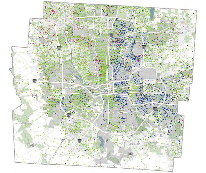
By 2050, Central Ohio
  will be a region of
 three million people
   - and mobility is
   a critical piece of
  preparing for that
        growth.

                         iii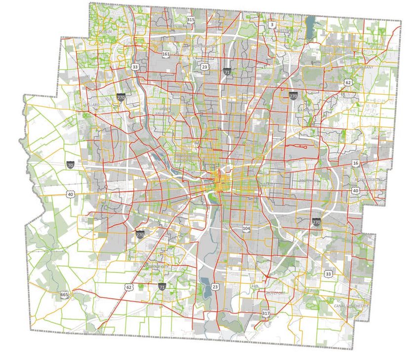
LINKUS | STATE OF MOBILITY REPORT

THE STATE OF MOBILITY REPORT
This “State of Mobility Report” is a foundational
assessment of the physical conditions and socio-
                                                                   The State of Mobility Report
demographic trends that affect how Columbus moves,
documenting our successes, and taking stock of our
                                                                   is a snapshot of our current
weaknesses. It is not a full accounting of our infrastructure      transportation and mobility
or all information relevant to the region’s mobility. It is
simply intended to set the stage for defining and shaping a        reality.
new mobility future.

 Note: Throughout this report, the name Columbus is used as shorthand to generally refer to the Central Ohio/Franklin
 County area that is the focus of the data cited, except where data sources are specified as the City of Columbus.

DATA SOURCES
Data points highlighted in this report represent Franklin County, unless otherwise stated. It should be noted that
the service area for COTA goes beyond the Franklin County border. In addition to data provided directly by the City of
Columbus, COTA, MORPC, and Franklin County, this majority of the data in this report uses sources described below:

American Community Survey (ACS)                                 ESRI Business Analyst Online (BAO)
The ACS is an ongoing survey by the US Census Bureau            ESRI BAO is a demographic mapping software that uses
that collects detailed population and housing information       census data to analyze and project population, business,
on a yearly basis down to the block group level.                lifestyle, spending, and more with map-based analytics.

Urban Footprint                                                 Walk Score
Urban Footprint is a dynamic mapping tool that                  Walk Score provides ratings between 0 and 100 that
utilizes census data and other sources to create visual         measure the walkability, bikeability, and public transit
representations of complex data sets for cities.                access for locations using patented methods of analysis.

Housing & Transportation                                        US Census Longitudinal Employer-Household
Affordability (H+T) Index                                       Dynamics (LEHD) OnTheMap
The HTA Index provides data on housing and                      LEHD OnTheMap provides information on employment
transportation costs for population and households.             that is compiled from several US Census sources.

Urban Suburban Rural Opportunity Index                          Zillow Research
The Urban Suburban Rural (USR) Opportunity Index was            Zillow Research provides housing data that offers
developed as a collaboration between the Ohio Housing           generalized measures of typical home values and rents.
Finance Agency (OHFA) and the Kirwan Institute for the
Study of Race and Ethnicity at The Ohio State University.

The State of Mobility Report was prepared by:

Consultant:

iv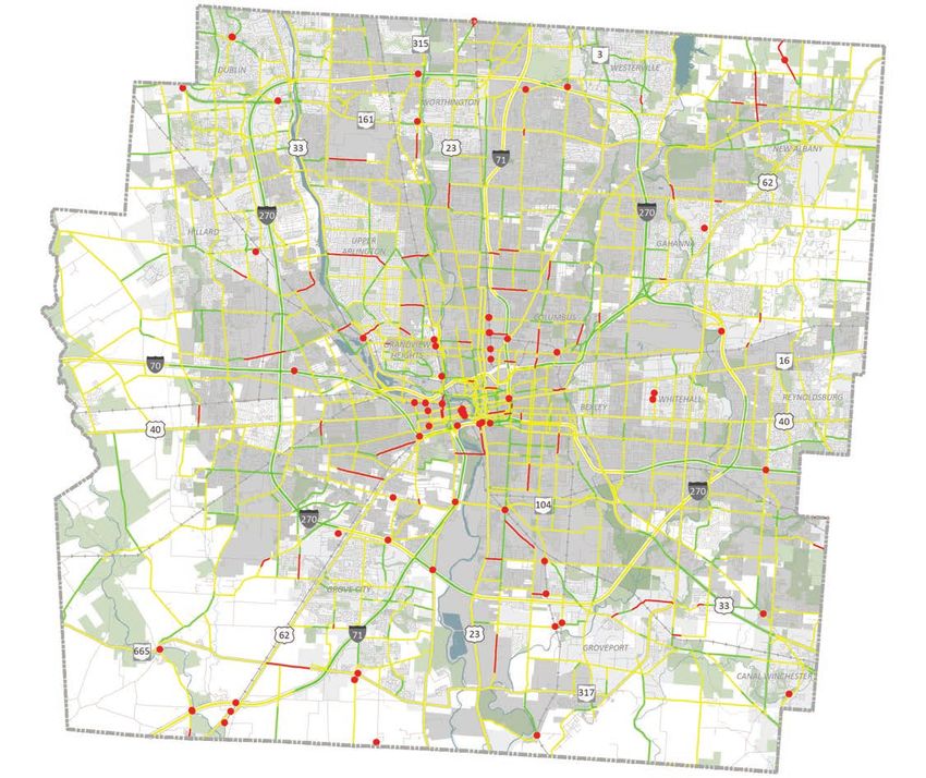
Contents
Our
FOUNDATIONS
                                   02
  Development and History
  Alignment of Efforts
  Our Priorities
        Equity
        Growth and Diversity
        Economic Competitiveness
        Public Health

Our
MOBILITY
                                   18
  Travel Patterns
  Affordable Travel
  Transit
  Vehicular Travel
  Asset Management
  Bikeability
  Walkability
  Greenways, Trails, and Parks
  Safety and Sustainability
  Emerging Trends

Our
PEERS
                                   38
  The Peer Cities
  Growth and Affordability
  Mode Split and Vehicle Travel
  Bike - Walk - Transit

CONCLUSION
                                   44

                                        1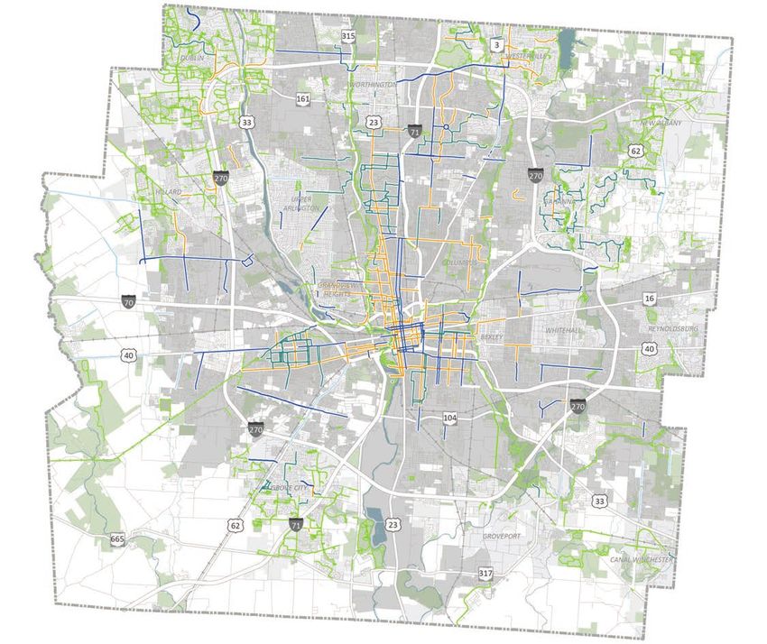
OUR

FOUNDATIONS
This section highlights the fundamental and foundational characteristics that influence the LinkUS process and mobility
throughout Columbus.

DEVELOPMENT AND HISTORY
Central Ohio Growth and Urbanization                                                                                City of Columbus
                                                                                                                   Other Municipality

1950
Following World War II, the baby boom, an increase
in private car ownership, less reliance on transit,
                                                              375,901
                                                      Columbus Population
and other factors caused Columbus to grow rapidly
                                                         74% of County
in size and population. Growth accelerated beyond
Downtown, ushering in a period of dramatic
suburban growth and expansion during the 1950s                      40
and 1960s. Local and national policies supported    Square Miles in Columbus
the increased suburban growth, but they also              7% of County
perpetuated racial segregation through continued
redlining (which pre-dates 1950) and urban renewal.

1970
Columbus experienced the economic turmoil of
the 1970s, but population and geographic growth
                                                              539,677
                                                          Columbus Population
still proceeded at a high rate. This is due in part
                                                             65% of County
to a diversified economy in the region. Population
growth in Columbus during the 1970s was nearly
15%, and the City has grown by an average of 54                    148
square miles per decade since 1950. Much of that       Square Miles in Columbus
growth has come from increasing suburbanization.            27% of County

2020
Following a slowdown in growth during the 1980s,
Columbus has continued to grow in population by
                                                              902,674
                                                          Columbus Population
over 10% each decade from 1990 to present. In the
                                                              (per MORPC)
early 1990s, it became the most populous city in
                                                             68% of County
Ohio. The city’s economy grew in these decades,
and is now home to six Fortune 500 corporations
and one of the largest universities in the United                  225
States. Due to its diversified economy, Columbus       Square Miles in Columbus
was not as affected by the late-2000s recession as          41% of County
other cities in the state.

2                                            Page Source: ESRI Business Analyst (2020), City of Columbus, Planning Division (2020), MORPC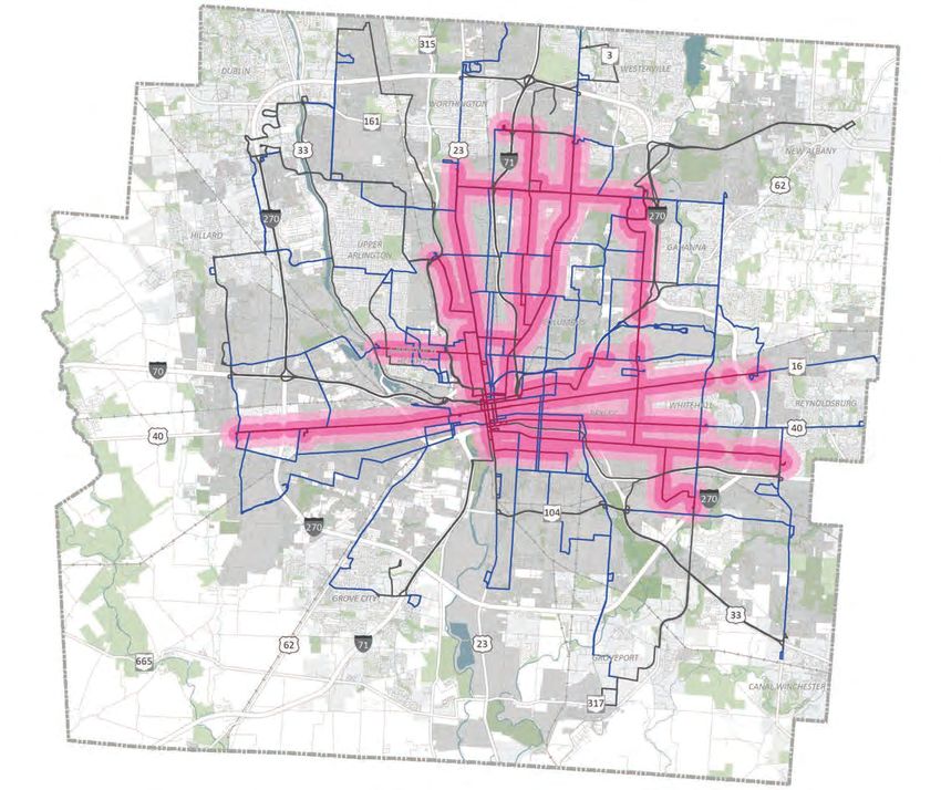
OUR FOUNDATIONS

Mobility Evolution
 Construction began on the first federal funded                 The first railroad reached Columbus in 1850:
 interstate highway known as the National                       the Columbus & Xenia Railroad. Sixteen steam
 Road (US-40) and crossed through Columbus.                     railroads would eventually serve Columbus, the
 Construction began on the East Coast and                       last of which was built in 1930. Amtrak’s National
 extended through Illinois.                                     Limited last traveled through Columbus in 1979.

  1806                           1825                            1850                             1851
                                Construction begins on the Ohio-Erie Canal to                    Union Station is constructed. The station served
                                connect Lake Erie with the Ohio River. The canal                 railroad passengers in Columbus until it’s
                                passed through Groveport and Lockbourne in                       demolition in 1979.
                                southern Franklin County, with a Columbus
                                Feeder Canal from the Scioto River.

 Started transition from streetcars to motor bus                     Streetcars pulled by horses are replaced by
                                         service.                                             electric streetcars.

                                          1933                            1895                             1888                           1863
                                    Columbus is served by nine interurban lines                   The first Streetcar Line opened on High Street
                                    between 1895-1939, reaching cities such as                    between Mound Street and Naughten Street.
                                London, Springfield, Marion, Delaware, Newark,
                                          Zanesville, Circleville and Chillicothe.

 I-70, I-71, and the I-270 outer belt are
 constructed, making it easier to travel regionally
 by vehicle and leads to the growth of suburban                 Central Ohio voters pass a transit levy, which
 municipalities along I-270. Communities of color               leads to the creation of the Central Ohio Transit
 were often negatively impacted.                                Authority (COTA).

  1950’s - 1960’s                 1965                           1973                              1990’s-2000’s
                                The last trackless electric trolley coaches in                   I-670 is completed, leading to quicker automobile
                                Columbus are retired and replaced by diesel                      travel to northeastern areas of the county
                                buses.                                                           and surrounding counties and encouraging
                                                                                                 development of areas near Easton, Gahanna, and
                                                                                                 New Albany.

    The US-33 Smart Mobility Corridor opens as                     Columbus wins USDOT Smart City Challenge.
   a real-world proving ground for autonomous                     Goals include improving quality of life, driving
    and connected vehicles. The corridor is one               economic growth, providing better access to jobs
   of the country’s premiere smart highways for                  and ladders of opportunity, becoming a world-
            autonomous and connected testing.                  class logistics leader, and fostering sustainability.

                                          2018                            2018                              2016                        2015
                                    COTA initiates CMAX on Cleveland Avenue                   MORPC establishes the Central Ohio Greenways
                                between Downtown Columbus and Westerville.                       (COG) Board to advance a vision for a world-
                                                                                              class network of trails easily accessible to every
                                                                                              Central Ohioan. Columbus implements the first
                                                                                               physically protected “cycletrack” in the region.

 COTA establishes the Downtown CPASS
 partnership with the Downtown Special                          COTA, Columbus and MORPC pilot Mobility
 Improvement Districts (SID), leading to increased              Innovation Tests to demonstrate the effectiveness
 transit ridership by commuters to Downtown.                    of dedicated transit and shared mobility lanes.

  2018                            2019                           2019                             2020
                                COTA//Plus on-demand micro-transit is launched,                  The LinkUS initiative is launched as a regional
                                which now includes four service areas.                           partnership to implement the next era of
                                                                                                 mobility investments needed in Columbus and
                                                                                                 Central Ohio.

                                                                                                                                                     3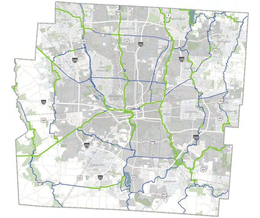
LINKUS | STATE OF MOBILITY REPORT
Historical Context
EXPANSION OF CITY BOUNDARIES INTERSTATE HIGHWAY
During the first half of the 20th century, the City of
Columbus grew slowly, encompassing approximately 40
CONSTRUCTION
As development sprawled outward from the urban core,
square miles by 1950. This pattern changed significantly
there was a mounting need for regional transportation
as the 1950s marked the beginning of a new era of growth
corridors to reach the growing suburbs. The Federal Aid
for Columbus and neighboring municipalities. This growth
Highway Act, passed in 1956, provided federal funding for
was driven by multiple factors, both national and local in
an interstate highway system. Ohio utilized the funding
scope. The cumulative impact was continued territorial
to build approximately 1,000 miles of pavement by the
expansion that by 1980 saw the city quintuple in size.
1970s, including four interstate highways in Columbus.
The City of Columbus’ annexation policy meant that the
While these new transportation corridors provided
vast majority of new development took place in Columbus
more direct access and reduced travel times, they also
or in one of the suburban communities to which it
bisected established communities, many of which were
extended utility services. Federal housing policies and
historically Black neighborhoods. Often the new highways
highway construction contributed to suburbanization,
were deliberately planned to disrupt areas that had been
as did the region’s strong and diverse economy. An
redlined and considered hazardous. For example, I-70,
additional factor contributing to suburbanization was
I-71, and I-670 split predominantly Black neighborhoods
the out-migration of middle-income, predominantly
on the Near East Side and cut the communities off from
White residents from the Columbus City School District in
downtown, continuing the history of discriminatory
response to school desegregation and the use of busing.
housing practices that contributed to the area’s declining
This led to substantial growth in suburban school districts.
standard of living and ability to attract investment.
Additionally, resulting low density and un-walkable
development patterns made other mobility options, like
transit, far less accessible.
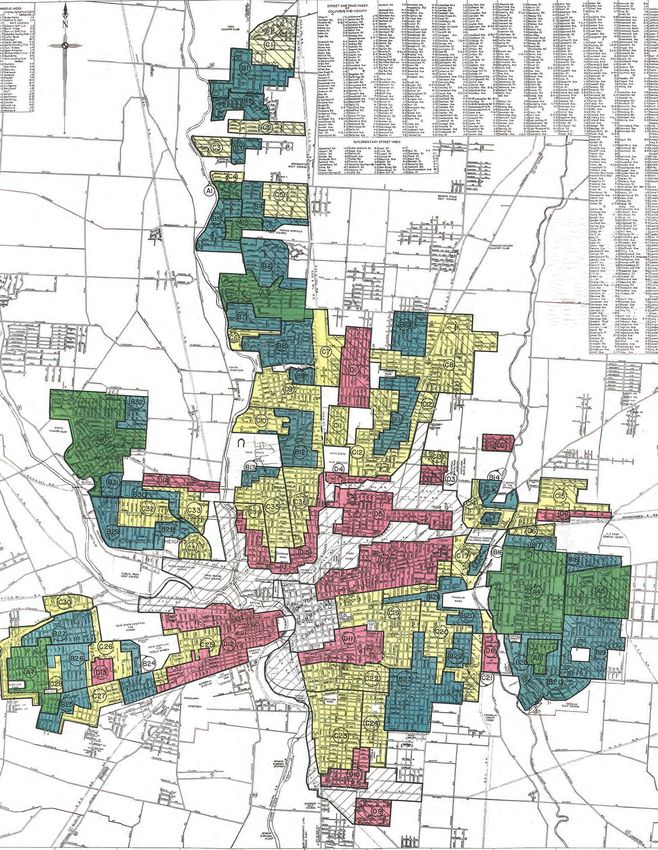
DISCRIMINATORY HOUSING POLICIES
Similar to other communities across the country, there were categorized as green (most desirable), blue (still
is a history of racially discriminatory housing policies desirable), yellow (declining), and red (hazardous/highest
in Columbus that have perpetuated segregation and risk). African American and immigrant communities were
influenced the economic inequality that continues to the typically classified as red, or “redlined”. According to the
present day. As a response to the influx of Black residents National Community Reinvestment Coalition, 82% of the
as part of the Great Migration from the south to the Columbus neighborhoods desginated as “hazardous” by
north in search of better opportunities, racially restrictive the HOLC were low to moderate income in 2018, higher
covenants became a popular tactic to create and maintain than the national average of 74%. Approximately 89% of
White-majority neighborhoods. Nearly two-thirds of the Columbus neighborhoods designated as “desirable” by
subdivisions platted in Central Ohio had restrictive the HOLC were middle to upper income in 2018 and over
covenants placed on them that prohibited the sale to 90% White.
Black residents (owu.edu).
The limited opportunity for homeownership, especially
The division between affluent White and non-White of high-quality homes in desirable areas, for minority
neighborhoods was further cemented through the process residents is especially damaging to upward mobility
of redlining. In 1935, as part of the New Deal, the Home and has had a lasting impact given the key role that
Owners Loan Corporation (HOLC) funded the creation of homeownership plays in wealth accumulation and the
residential security maps which ranked areas based on a intergenerational transfer of wealth. For this reason, the
biased view of desirability versus risk for mortgages. Areas impacts of redlining are still seen today.
We should reconcile the negative outcomes of our past decisions
and prioritize equitable mobility investment in the future.
4 Page Source: owu.edu, columbusalive.com, dispatch.com, columbusnavigator.com, teachingcleveland.org, City of Columbus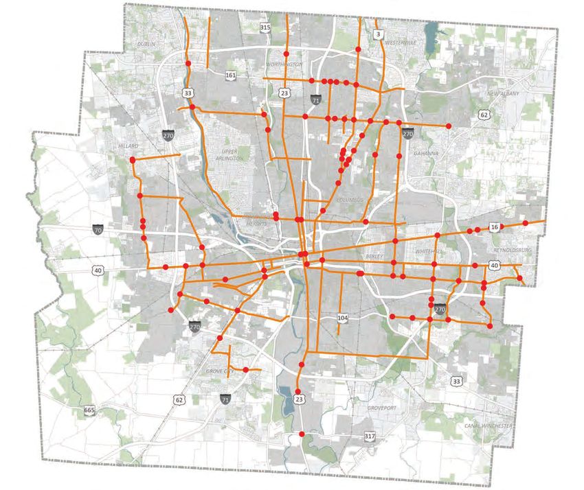
OUR FOUNDATIONS

          HISTORICAL REDLINING MAP (1936)

Source: owu.edu                                           5
LINKUS | STATE OF MOBILITY REPORT

ALIGNMENT OF EFFORTS
LinkUS is a critical element to the success of other key initiatives aimed at expanding equity, opportunity, and prosperity
for the region. We won’t achieve our vision for the region without creating alignment between these elements.

CRITICAL INITIATIVES                                            DESIRED OUTCOMES
Those initiatives that are most critical to achieving our       The key outcomes that should
desired outcomes.                                               be a result of our initiatives.

SUPPORTING INITIATIVES                                                                                 Active
The supportive initiatives provide a foundation for our                                            Transportation
critical initiatives. This page highlights many supporting                                              Plan
initiatives, but is not limited to only these. There are many
aligned initiatives within the region that are critical to                     Regional
advancing desired outcomes.
                                                                              Prosperity
       Franklin                                                                Agenda
       County
                                                                                                     Broadband
       Housing                                      Celebrate One
                                                                                                       Access
       Magnet
         Fund                Access to
                           Quality Jobs &                                  Quality of Life
                             Housing
      Central
        Ohio                                          EQUITABLE                                         Rapid 5
     Greenways                                         GROWTH                                          Initiative
       Vision
                              Columbus                                         Regional
                             Zoning Code                                       Housing
                               Update                                          Strategy
                                                                                                     Columbus
         Rise
                                                                                                      Rec and
       Together                                             LinkUS
                                                                                                     Parks Land
       Blueprint
                                                                                                        Plan
                           Transportation                                  Public Health
                              Choices                                         Equity
                                                                                                       Central
      Regional
                                                            Focused                                     Ohio
      Complete
    Streets Policy
                                                            Growth                                 Transportation
                                                                                                     Safety Plan
                            Climate Action
6                                                                             Vision Zero
                                 Plan
OUR FOUNDATIONS
Mobility investment is
a critical component to
achieving the desired
outcomes of our
region.
7LINKUS | STATE OF MOBILITY REPORT
OUR PRIORITIES
LinkUS Priorities
Access to jobs, housing choices, education and healthcare are fundamental to individual opportunity and regional
success. Improving mobility in the Columbus region while focusing on these critical priorities established in the LinkUS
Framework Strategy will create connections that put these goals within reach. The LinkUS initiative focuses on six critical
priorities:
EQUITY ECONOMIC DEVELOPMENT
The introduction of mobility options allows for increased Enhanced mobility encourages public and private
and equitable access and opportunity for all members of investment in transportation and development. This
the community. Mobility is critical to improving equity in promotes local and regional economic vibrancy.
the region.
WORKFORCE ADVANCEMENT AFFORDABILITY
Increased travel choice and connectivity better links jobs More transportation choices improve the affordability
with the workforce, promoting economic vibrancy and of our community by reducing transportation costs. This
equity. reduction of combined housing and transportation costs
also creates a more equitable region.
INNOVATION SUSTAINABILITY
Mobility creates greater opportunities for more Increased mobility and additional transportation choice
innovation between our people, places, and shared lowers automobile dependence to reduce
prosperity. Technological innovations in transportation carbon emissions. By coupling enhanced mobility with
make a more efficient system, promoting the region’s compact, walkable development patterns, growth can
economy and sustainability. occur in the region while also preserving farmland and the
natural environment.
8OUR FOUNDATIONS
RISE TOGETHER: A Blueprint for Reducing
Poverty in Franklin County
The Franklin County Commissioners began an initiative
to analyze the causes of poverty that are unique to
Central Ohio. In doing so, they developed Rise Together: A
Blueprint for Reducing Poverty in Franklin County. Led by
a diverse steering committee of experts and community
members, the plan identifies four critical goals - all of
which directly relate to equity and public health:
1 Increase access to high-paying jobs
2 Stabilize housing for families near or below poverty
Improve physical, mental, and behavioral
3 health, and overall well-being through increased
access to care, utilization of services, and social
connectedness
Ensure all young people are on track for long-term
4 success
Our established
priorities should
guide our mobility
investment decisions.
9LINKUS | STATE OF MOBILITY REPORT
EQUITY
Income
The median household income for
Franklin County is around $61,000 while
that of the City of Columbus is nearly
$54,000. Median household income is
crucial to understanding the associated
transportation and cost burdens a
community--or subset of a community-
-faces. Access to transportation is one of the highest
indicators of job accessibility and economic mobility.
Lowest income households
are primarily inside I-270 to
the northeast, east, west, and
south of Downtown.
Race
In Franklin County, the percentage of the
population that identifies with a racial
or ethnic group other than White is
approximately 34%. In the City of Columbus,
the total percentage of ethnic and racial
minorities is slightly higher at 41%. The figure
shows the minority population divided by the
total population in each census designated
block group. Notably, the geographic
distribution of minority populations is more
heavily concentrated on the City’s east side between
I-71 and I-270. Across the country in large metro areas
like Columbus, race and ethnicity are generally strong
indicators of those who take alternative modes of
transportation. This is evident in COTA’s most recent On-
Board Survey data that indicated that a majority of transit
riders were from minority populations.
Minority neighborhoods are most heavily concentrated in the
eastern part of the City of Columbus and Franklin County.
10 Page Source: US Census American Community Survey (2019)OUR FOUNDATIONS Opportunity A successful mobility system should connect the opportunity, housing opportunity, and health opportunity, community to those destinations and opportunities among other factors. In Franklin County, the areas of most critical for livability. The map below uses an index highest opportunity are located primarily northwest of opportunity indicators developed as a collaboration of Downtown, other areas surrounding the Ohio State between the Ohio Housing Finance Agency (OHFA) and University, and the far northern corners of the County the Kirwan Institute for the Study of Race and Ethnicity (and beyond into Delaware County). The areas of least at the Ohio State University. The index relies on data opportunity include many neighborhoods directly north, from the U.S. Census American Community Survey south and east of Downtown. Simply put, the higher the and uses 15 total indicators to measure transportation index level, the better the opportunities to thrive. opportunity, educational opportunity, employment Our areas of lowest opportunity are primarily low income, minority communities. Page Source: Ohio Housing Finance Agency (OHFA) 2020-2021 USR Opportunity Index 11
LINKUS | STATE OF MOBILITY REPORT

GROWTH AND DIVERSITY
Demographic Fast Facts
      1,308,547                        22.4%                               +25%                                     67.9%
 Franklin County Population       Increase in Population     Projected Regional Growth                   Franklin County Population
           (2020)                      (Since 2000)              from 2010 to 2040                         in the City of Columbus
                                                                    (Insight2050)                                    (2020)

Population Growth                                            City, County, and Regional Population Growth
The total population of Franklin County increased by         2,500,000
                                                                                                                                       2,126,001
nearly 240,000 residents in the last two decades, an                                                           1,901,974
                                                             2,000,000
overall growth rate of 22.4% and a compound annual                                     1,674,737
growth rate of 1.0%. Franklin County’s population grew at    1,500,000                                                       1,308,547
a faster rate during the 2010s (12.5%) than in the 2000s                     1,068,978
                                                                                                      1,163,414
(8.8%), contrary to state and national trends of a decline   1,000,000                                                     888,145
                                                                                                   787,074
                                                                           719,332
over the past decade.
                                                              500,000

     The region will continue to see                                   0
                                                                                     2000                    2010                    2020
     strong and consistent growth.                                  City of Columbus           Franklin County         Columbus, OH MSA

Age                                                          Age Distribution and Change (Franklin County)
The 25 - 44 age group (mostly made up of Millennials)        250,000                                                                        80%
make up nearly 29% of the population. However, the 55-                                                                                      70%
74 age group (mostly made up of Baby Boomers) has seen       200,000                                                                        60%
70% growth since 2010 and is estimated to continue to be                                                                                    50%
                                                             150,000
the largest-growth age group in coming decades.                                                                                             40%
                                                                                                                                            30%
                                                             100,000
     Given the aging population,                              50,000
                                                                                                                                            20%
                                                                                                                                            10%

     investment should consider                                                                                                             0%
                                                                   0                                                                        -10%
     multimodal accessibility for                                          0-14 15-24 25-34 35-44 45-54 55-64 65-74 75-84 85+
                                                                                      2010              2020               % Change
     people of all ages and abilities.
                                                             Racial Distribution (Franklin County)
Diversity                                                               Asian/Pacific
                                                                                             Other Race,
                                                                                                2.9%                Two or More
                                                                       Islander, 6.2%                                Races, 3.7%
A majority of residents in
Franklin County identify as
                                      36.7%                    American
                                    Minority Population
White (63.3%), followed                                      Indian, 0.2%
by those who identify as Black (23.7%). The third largest
racial group is Asian/Pacific Islander (6.2%). The County
is more diverse than Central Ohio as a whole. However, it
should be noted that diversity is anticipated to continue
to increase in the coming decades due to in-migration and       Black, 23.7%                                                   White, 63.3%
specifically international immigration.

12                                                                                                 Page Source: ESRI Business Analyst (2020)
OUR FOUNDATIONS
Population Density by Race
The map below shows population density by race Minority races make up about 37% of Franklin County’s
throughout the county by block group, where one dot is population, with about 24% being Black or African
equal to 100 people. Franklin County's population density American. The map shows a spatial distribution of race
is generally greater in the urban areas of Columbus and where the majority of Black or African American residents
the surrounding municipalities while less dense in the generally live between the major highways, between I-71
unincorporated areas of the county. The population is and I-270 in the eastern part of the county. Compared to
particularly dense within and around the I-270 beltline the Black population, the Asian population has a different
and closer to the urban core. spatial distribution, residing mostly north of I-70 and
north of I-270 in the western part of the county.
Our most densely populated areas, many of which have
significant minority population, are most likely to need access to
multiple transportation options.
Page Source: US Census American Community Survey (2019) 13LINKUS | STATE OF MOBILITY REPORT
ECONOMIC COMPETITIVENESS
Top Employers and Economic Drivers
The region’s top employers are economic drivers that heavily influence transportation and mobility - as getting workers
to and from jobs safely and efficiently on a daily basis is vital to the economic success of an area. The Columbus
Partnership and One Columbus tracks the top employers in the region. The top five in Central Ohio are outlined below.
The Ohio State University State of Ohio JPMorgan Chase
The Ohio State University employs As the state’s capital, Columbus is The investment banking company has
approximately 34,416 people, making home to the Ohio Statehouse and served the region for 150 years and
it Central Ohio’s largest employer. As offices of other state departments employs 18,596 people in Central
of fall 2020, there were nearly 68,000 and agencies with an estimated Ohio, making it the region’s largest
students enrolled. 23,254 regional employees. private employer.
OhioHealth Nationwide Insurance
Headquartered in Columbus, the Headquartered in Columbus,
healthcare system operates a Nationwide employs 13,710 people
network of 12 hospitals and over in Central Ohio. The Fortune 100
200 ambulatory sites that span 47 company offers a full range of
counties in Ohio. In Central Ohio, insurance and financial services.
there are 24,889 employees.
Job centers in Columbus are largely influenced by the four main economic drivers listed below:
Higher Education Healthcare Finance, Insurance, Tech
• The Ohio State University • Nationwide Children’s Hospital • Franklinton
• Columbus State Community College • Ohio State University Wexner • Arena District
• Columbus College of Art and Design Medical Center
• Capital University • OhioHealth Retail
• Franklin University • Easton
• Ohio Dominican University Government (Local, State) • Polaris
• Otterbein University • Downtown • Short North
All Other
Top Industries Industries,
43.9%
Health Care and
Social Assistance,
According to census data, as of 2018, Franklin County 14.8%
hosted more than 720,000 jobs. Health Care and Social
Assistance is the largest industry, accounting for 14.8% Retail Trade,
of all jobs in the county, and has also added the most
720,789
9.1%
jobs over the previous five years. The county’s economy
is relatively diversified, with the five largest industries Franklin County Jobs
comprising less than half of the employment base. (2018) Educational
Services, 9.0%
Continued growth in our Finance and
diverse economy should be Insurance,
7.8%
supported by investment in Accommodation and
Administrative and
our mobility. Waste Services, 7.8% Food Services, 7.7%
14 Page Source: Columbus Partnership (2020), US Census Center for Economic Studies - OnTheMap (2018)OUR FOUNDATIONS
Job Density As the number of jobs
The map below displays job density where the highest continue to increase in
concentrations are in Downtown Columbus, near OSU,
and in other areas directly adjacent to I-270 such as the County, workers will
Easton, Dublin, and Westerville. In addition to these job
centers, jobs are fairly distributed throughout the County, require affordable, safe, and
creating a higher reliance on vehicular travel, particularly
for those job centers near and outside of I-270.
sustainable options to get
Franklin County supports many jobs: in addition to the
them to work.
over 471,000 people that live and work within the county,
about 302,000 people commute into the county every day 12,824 28.7%
to work as well. This is compared to the around 155,000 Avg. Annual Net New Jobs Growth in Transportation
people that live within the county but work elsewhere. (2012 - 2018) Sector Jobs since 2013
Page Source: US Census Center for Economic Studies - OnTheMap (2018) 15LINKUS | STATE OF MOBILITY REPORT
PUBLIC HEALTH
Food Access
A food desert is an area that has limited
access to affordable and nutritious foods,
typically defined as people who live more
than one mile away from a supermarket or
grocery store. The adjacent map displays
food deserts by the percentage of low-
income residents in a census tract that
live more than one mile away from a
supermarket.
In 10% of our block groups,
25% or more of the low-
income population lives
more than one mile from a
supermarket.
Public Health Index (Chronic Disease)
The Public Health Index utilizes Chronic
Disease data from the Centers for
Disease Control and Prevention (CDC).
The Chronic Disease data shows the
percentages of individuals living with
chronic disease or underlying risk factors.
The CDC focuses on creating policy
and environmental strategies to make
active living accessible and affordable to
everyone. The index considers five key
factors including obesity, diabetes, asthma, lack of access
to health insurance, and doctor visits. Identifying areas
of higher concern will allow planners and policy makers
to encourage active transportation opportunities in
these areas and provide them better access to medical or
healthcare facilities.
Mobility investments that provide more access to active
transportation options and to critical destinations can have
measurable impacts on public health outcomes.
16 Page Source: UrbanFootprint – USDA Economic Research Service (2017); Centers for Disease Control and Prevention (2018)OUR FOUNDATIONS Social Vulnerability Index The term "social vulnerability" refers to the potential some of which include poverty, lack of vehicle access, adverse effects on communities caused by external and crowded housing occupancy. These social factors stresses on human health. Identifying communities that are grouped into four related themes: socioeconomic are considered socially vulnerable can provide insight into status, household composition, race/ethnicity/language, areas that would benefit from transportation investments. and housing/transportation. Each block group receives a The Social Vulnerability Index – developed by the CDC – separate ranking for all four themes as well as an overall utilizes U.S. Census data to help identify communities that ranking. The map below shows the overall ranking of social may need support before, during, or after disasters. vulnerability in Franklin County. The index itself is a combination of fifteen social factors, Socially vulnerable communities correlate strongly with high chronic disease risk, including greater COVID-19 impacts. Page Source: UrbanFootprint – Centers for Disease Control and Prevention (2018) 17
OUR

MOBILITY
This section assesses the critical elements of the transportation system and community that most affect mobility in
Columbus. This assessment includes analysis of important demographic characteristics and each travel mode.

TRAVEL PATTERNS
Mode Distribution
Over 80% of all County residents drove alone in an
automobile every day to their pre-pandemic place of
                                                                        80.9%
                                                                       Drive Alone
employment. This is four points higher than the national
average (76%). This paints a picture of Franklin County as
a highly car-dependent community.
                                                                         7.8%
Creating a more sustainable distribution of travel: Mode                 Carpool
Shift, supports transportation equity and affordability.
It reduces our reliance on driving, which supports goals                                                                 SOV
around climate, congestion, and growth management. It                                                             Single-Occupancy Vehicle
also creates enhanced travel choices and advances our                    4.8%
Vision Zero safety commitment.                                      Work from Home

Generally, relative to peer cities, congestion isn’t as bad as
other places. However, the projected growth of the region
to three million people by 2050 will quickly change that.                3.1%
The Sustainable Columbus Climate Action Plan specifically               Bike/Walk
highlights “Supporting Equitable Mode Shift” as a key
goal, and identifies target metrics for reducing vehicle
miles traveled (VMT) and more. Identifying a potential
mode shift target will provide more transportation options               2.4%
and help to manage future growth.                                      Public Transit
                                                                                                                              *0.9% Other

         88.7%                             5.5%                                -15%                               -25%
  Daily Commute Trips that        Daily Commute Trips that          Target Reduction in Vehicle         Target Reduction in Vehicle
     Use a Motor Vehicle          Use an Alternative Mode             Miles Traveled by 2030              Miles Traveled by 2030
   (85% National Average)         (8.1% National Average)              (Climate Action Plan)               (Climate Action Plan)

     Increased mode shift reduces SOV travel and helps prevent
     future congestion due to new growth. This will be critical as
     Columbus and Central Ohio continue to feel the pressures of
     sustained growth.

18                                      Page Source: US Census American Community Survey (2019), Sustainable Columbus Climate Action Plan
OUR MOBILITY Single Occupancy Vehicle (SOV) Distribution A single occupancy vehicle commute is when a single traffic congestion, a more diverse mode-split is ideal in person drives to work alone. Other means of commuting large metropolitan centers. The average commute time in include public transportation, carpooling (two or more Franklin County is around 22 minutes. people), walking, or bicycling. To avoid high levels of Due to more access to multimodal options, commuters less likely to travel alone in a vehicle are closer to the urban core. Investment in high-capacity transit and other multimodal options will help to lower SOV travel in surrounding areas as well, while managing congestion. Page Source: US Census American Community Survey (2019) 19
LINKUS | STATE OF MOBILITY REPORT

AFFORDABLE TRAVEL
Vehicle Access
Over 38,000 Franklin County households
do not have access to a car. In a metro
area like Columbus that has been
primarily designed and developed for
vehicular travel, it is very difficult to move
through the City and County without one.
This is especially true for those within
vulnerable communities who are less
likely to be able to afford a vehicle. Over 7% of households
in Franklin County (and over 13% of renter households) do
not have access to a vehicle.

     Over 38,000 households in
     Franklin County do not have
     access to a vehicle.
Low-Wage Living
The figure on the right shows the
areas where workers live who make
less than $15,000 per year (which is
roughly $1,250 a month). Generally, the
concentrations of low-wage workers are
consistent with areas of low opportunity
from the Opportunity Index. The area
around OSU shows some of the highest
concentrations of lower-wage workers
in Franklin County, largely due to the
student population. Workers with an income less than
$15,000 are less likely to have access to a personal
vehicle and may use other means to get to and from
work. By creating multimodal transportation options
and choices, not only will the quality of life improve for
residents overall, but it will also benefit the County's most
vulnerable populations.

     Low-wage workers generally live in our areas that have the
     lowest access to opportunity. Affordable multimodal options will
     serve these populations and improve economic competitiveness.

20                        Page Source: US Census American Community Survey (2019); US Census Center for Economic Studies, OnTheMap (2018)
OUR MOBILITY
Cost-Burdened Households
This map displays housing cost burden by block group in costs (based on median gross rent and median selected
Franklin County. The United States Department of Housing monthly owner costs). The weighted average share of
and Urban Development defines cost-burdened families household income spent on housing costs (which also
as those who spend 30% or more of their median income includes utilities, taxes, insurance, etc.) for renters and
on housing expenses. Areas of the highest burden include homeowners was calculated for each block group to
areas inside I-270 including Franklinton, Linden, the South determine whether households were considered cost
Side, and student housing areas near OSU. To measure burdened on average. The shares of households living
housing cost-burden at the block group level, data from within block groups with an average that is considered
the ACS 2015-2019 5-Year Estimates was obtained for the cost-burdened or approaching cost-burdened, were also
percentage of household income spent on total housing calculated (see below).
Households in Cost-
Burdened Block Groups
Approaching Cost-
Burdened (25% - 30%)
Cost-Burdened
(30% or more)
Cost-burdened households
# of Households 82,560 60,259 are primarily in our more
% of Households 16.1% 11.8%
vulnerable communities.
Page Source: US Census American Community Survey (2019) 21LINKUS | STATE OF MOBILITY REPORT
TRANSIT
Transit System Characteristics
19 Million +4% 87 1,235,664
Passenger Trips per Year Ridership Increase Since Frequent Bus Route Miles CMAX Rides
(19.1 Million in 2019) System Redesign (15 Minute Headways) (2019)
The Central Ohio Transit Authority (COTA) provides regional public transit services for the greater Columbus area, hosting
more than 19 million passenger trips each year. It should be noted that during the COVID-19 Pandemic, services have
been reduced. COTA aims to connect people to prosperity through safe, reliable, and cost-effective services. The system
received the 2018 and 2020 Outstanding Public Transportation System Achievement Awards from the American Public
Transit Association, demonstrating a high level of customer satisfaction. COTA is primarily funded by sales tax revenue, as
well as by federal and state grants and passenger fares. The recent launch of the COTA // Plus rideshare service provides
users with access to on-demand rides via a mobile app. COTA recently conducted an on-board survey in 2018 that
yielded meaningful results:
48.4% 49.7% 51.3% 48.2%
Passenger Trips are Have No Access to a Have a Household Income Have No Valid
Between Home and Work Vehicle in their Household Below $25,000 Driver’s License
93.8% 56.1%
Walk to Access Transit Minority Passengers
During the COVID-19 Pandemic, a signficant chunk of the
essential workforce still relied on COTA for daily commuting.
COTA System Plan
COTA’s 2020-2050 Short & Long Range Transit Plan
(completed in May 2020) outlines the system’s short-
(2024) and long-term (2050) visions to expand services in
the growing Columbus region. The planning process was
guided by a desire to improve the customer experience,
provide enhanced access to mobility options, and
prioritize the use of data to inform decision-making. The
map to the right showcases the proposed improvements
to the transit network.
COTA’s NextGen Vision aims
to support smart growth and
act as a backbone of a more
equitable transit network.
22 Page Source: COTAOUR MOBILITY
Access to Transit
The map below illustrates the existing transit system Top Five Routes Top Five Stops
with an emphasis on access to premium transit (bus By ridership By ridership
routes that provide frequent service of 15 minutes or
• Line 2 - E Main/N High • E Broad St & S High St
less throughout the day). Five and ten minute walking
• Line 10 - E/W Broad • N High St & W Broad St
buffers (1/4 mile and 1/2 mile, respectively) were placed
• Line 1 - Kenny/Livingston • E Main St & S High St
on stops to highlight areas with access to strong transit
• Line 8 - Karl/S High/ • S High St & E Broad St
options. However, these buffers do not account for access
Parsons • W Long St & N High St
to pedestrian infrastructure such as sidewalks. The areas
• CMAX - Downtown/
with the most complete high-frequency transit service are
Polaris/Africa
corridors connecting to Downtown from the west, east,
and north.
Currently, high frequency transit is largely only concentrated
along the densest corridors in the County.
Page Source: COTA 23LINKUS | STATE OF MOBILITY REPORT
VEHICULAR TRAVEL
Commuting Patterns 39%
Commute From Outside
Franklin County
As Central Ohio’s economic engine, it is not surprising
that more people commute into Franklin County for work
than the number that commutes out. More than 283,000
people travel into the County each day for their job,
compared with over 144,000 that travel out. Over 437,000
people live and work within the County, making up
approximately 60% of the County’s workforce and 75% of
the County’s employed residents. The most popular origin
points for workers commuting from outside of Franklin
County are Delaware County (7.1%), Fairfield County
(4.3%), and Licking County (4.0%).
61%
Commute From Within
Franklin County
50% 23%
Regional Trips that are Less Household Income Spent
than Five Miles on Transportation
(MORPC) (Columbus MSA)
42% 28.6%
Commute Less than 20 Commute More than 30
Minutes Daily Minutes Daily
Although the percentage of workers with longer commutes
in Columbus has steadily gone up, average commute time by
traveling alone has barely changed since 2011. In the same time,
average commute time by public transportation has gone up by
nearly 10 minutes
A mobility strategy
that expands our
transportation choices
is critical to advancing
our regional priorities.
24 Page Source: US Census American Community Survey (2019), Columbus Foundation Benchmarking Report (2019)OUR MOBILITY
Traffic and Congestion
Annual average daily traffic (AADT) is a measure of the and the greater Columbus metropolitan area. Increased
total volume of vehicle traffic on a highway or road. High mode shift reduces SOV travel, which lowers traffic
traffic roads in Franklin County include I-70, I-71, I-670, volumes and associated congestion. Furthermore, it can
and I-270. These interstates are Franklin County's major mitigate future congestion from occurring as a result of
thoroughfares and outerbelt that encompass downtown new growth.
172,995 182,573 124,073 $1,000
Annual Average Daily Annual Average Daily Annual Average Daily Average Spent on
Traffic on I-71 Traffic on I-270 Traffic on SR-315 Commuting per Year
(Urban Mobility Report)
Our residents spend 50 extra hours per year on their daily
commutes due to rising congestion.
Page Source: ODOT (2019), Inrix Research (2018), Texas A&M Transportation Institute Urban Mobility Report (2019) 25LINKUS | STATE OF MOBILITY REPORT
ASSET MANAGEMENT
Pavement and Bridge Conditions
Good pavement is critical for safe and efficient county have been found to need significant structural
transportation, and due to the presence of numerous improvement, including on S Champion Road and Briggs
rivers, creeks, and other bodies of water, the Columbus Road in Columbus and on Bixby Road in Groveport. 71
area is also very dependent on its bridges. The following bridges in the county are identified as in poor condition,
map identifies the roads and bridges that are most in and there is a high concentration of these bridges near
need of repair or maintenance in Franklin County, as downtown and in southern and suburban areas of the
inspected in 2019-2021. Over 16 miles of roadway in the County.
16 59% 59
Miles of Road in Poor Non-Interstate Roads in Bridges Rated as Being in
Condition Less Than Good Condition Poor Condition
26 Page Source: MORPC (2021)OUR MOBILITY
We will need to
prioritize our mobility
investments to better
manage our current
assets while continuing
to develop new ones.
27LINKUS | STATE OF MOBILITY REPORT
BIKEABILITY
Current Bike Network
The existing bicycle network consists of a variety of bicycle like protected bicycle lanes and multi-use paths. There are
infrastructure. The facility types include bicycle lanes, approximately 122 miles of dedicated bicycle lanes in the
paved shoulders, shared bicycle lane markings, bicycle county. Paved shoulders and shared bicycle lane markings
boulevards, signed bicycle routes, and multi-use paths. are typically less than ideal as part of a network that aims
The safest types of bicycle facilities are those that are to accommodate all ages and abilities.
dedicated or physically separated from vehicular traffic,
122 1,249 136 27%
Miles of Existing Bike Lanes Miles of Existing Greenway Miles of Existing Bicycle Of the County’s Greenways
or Multi-Use Path Boulevard or Bike Routes or Multi-Use Paths inside
the City of Columbus
28 Page Source: MORPC (2021)OUR MOBILITY
Access to Bicycle Facilities
Bicycle Level of Traffic Stress is a measure of the bicycle Roadways that are Barriers to Biking
friendliness of a roadway, as measured by a range of for “Interested but Concerned” Cyclists
factors including separation from traffic, volume of traffic,
and vehicle travel speeds. The presence of a dedicated High Stress Streets
bicycle facility can convert a high-stress road to a lower-
stress route. The creation of low-stress routes along Medium Stress
22% 29% 37% 12% Streets
less-busy streets help to complete the bicycle network. A
Low Stress Streets
recent survey by the Ohio Department of Transportation
(ODOT) indicated that 45% of residents that are Residential Streets
“Interested but Concerned” in biking, and would be highly Suitable for Bikes
0% 50% 100%
unlikely to utilized medium and high stress streets.
Areas of low opportunity are less likely to have access to low
stress bicycle facilities.
Page Source: ODOT (2020), MORPC (2021) 29LINKUS | STATE OF MOBILITY REPORT
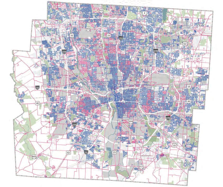
WALKABILITY
Sidewalk Access
Sidewalks in Franklin County are mostly concentrated in
denser areas, especially in the core of Columbus. However,
4,400 3,150
Miles of Existing Sidewalk Miles of Identified Gaps in
many neighborhoods have little to no access to sidewalks. in Franklin County Franklin County
Sidewalk gaps are of most concern in more urban areas
(as opposed to rural), on arterial roadways, and in areas
served by transit. As a point of reference, there are 2,555 Prioritizing sidewalk gaps,
miles of sidewalk within the City of Columbus, with 1,453
miles of identified gaps. Unsurprisingly, research indicates especially near transit, is
that streets without sidewalks are more likely to have
pedestrian crashes, especially on high-speed, high-traffic
critical to improving first/
roadways. Encouraging walking also promotes health and
economic benefits. Sidewalk gaps also present a particular
last mile connections and
barrier to those with physical disabilities. expanding safe access.
30 Page Source: MORPC (2021)OUR MOBILITY
The 21st Century
challenges that our
region faces can be
addressed in part with
proactive and targeted
investment in our
mobility.
31LINKUS | STATE OF MOBILITY REPORT
PARKS, GREENWAYS, AND TRAILS
Park Access
The Trust for Public Land (TPL) publishes an annual
“ParkScore” ranking for the 100 largest cities in the
68% 8%
City Residents Within a City Land Used for Parks
United States. Currently, the City of Columbus ranks 49th
10-Minute Walk from Park and Recreation
out of 100. The score takes into account several critical
(55% National Average) (15% National Median)
characteristics (acreage, investment, amenities, and
access) and scores each characteristic out of 100. As it
relates to mobility, Columbus scored 42 out of 100 on parks access, 54 out of 100 on park acreage, and 73 out of 100
on park investment, which takes into account the percentage of population living within 10 minutes of a public park,
physical barriers to access, walkability, bikeability, safety and more.
Residents in low-income neighborhoods have access to 17% less
park space per person than the city median and 28% less than
those in high-income neighborhoods.
Improving access
to parks through
mobility investment
is imperative to
improving public
health and equity
within the region.
32 Page Source: Trust for Public Land (2021)OUR MOBILITY
Regional Greenway and Trail Network
Greenways encourage sustainable development, promote
community connection, and improve quality of life. The
230 12 Million
Miles of Existing COG Miles Traveled on COG
existing multi-use pathways, bicycle trails, pedestrian trails
Network Each Year
and connections typically run along north-south stream
corridors like the Scioto River, Olentangy River, and others.
The network extends out from the core to cities like 500 40%
Dublin, Grove City, and New Albany. Miles of Identified Trails in High Poverty Areas Served
Regional Trail Vision Currently
The Central Ohio Greenways (COG) is an integrated
network of trails connecting parks, natural features, and
other key destinations in Central Ohio. COG envisions 45% 85%
a high-caliber trail network accessible to every Central Of Population Could Bike High Poverty Areas Served
Ohio resident. The Central Ohio Greenways Board has to a Trail From Home in the Future
developed a regional trail vision to add more than 500 (If COG Trail Vision is (If COG Trail Vision is
new miles of trails in the seven-county region. Implemented) Implemented)
Page Source: MORPC (2021) 33LINKUS | STATE OF MOBILITY REPORT
SAFETY AND SUSTAINABILITY
Climate Action Plan
At the February 2020 State of the City, Mayor Ginther
announced that Columbus is committed to becoming
A primary target of the CAP is
carbon neutral by 2050. To accomplish this goal, the City
of Columbus is in the process of developing a Climate
a 25% reduction in emissions
Action Plan (CAP), a set of integrated strategies intended by 2030.
to reduce greenhouse gas (GHG) emissions, prioritize
equity, and build local resilience to the changing climate.
Transportation Greenhouse Gas Emissions
Mobility-related strategies outlined in the CAP include:
Freight Public Transit
• Reducing vehicle miles traveled per capita (40% goal
reduction by 2050)
• Encouraging transit use (50% goal increase by 2050)
• Implementing micromobility solutions (goal of Aviation
accessibility by all residents within ½ mile by 2050)
Mobility specific policy and programmatic
recommendations include: Heavy/Med Passenger
Vehicles Vehicles
• Increased Transit Oriented • Promote medium/heavy
Development duty zero emission vehicle
• Increase equitable access adoption
to green space • Reduce miles traveled per
• Increase private electric capita
vehicle ownership • Increase transit use
• Implement zero carbon • Implement micromobility
fleets solutions
The largest proportion of transportation-related greenhouse gas
emissions come from SOV travel miles.
Air Quality
In Central Ohio overall, air quality is improving thanks
to local and national initiatives to reduce emissions. The
number of good Air Quality Index (AQI) days has been
increasing over time while the number of moderate
and higher days has been decreasing. The number
of unhealthy for sensitive groups and unhealthy days
varies from year-to-year due to differences in weather
conditions. Investment to reduce SOV travel will yield
continued positive trends on air quality.
34 Page Source: City of Columbus Climate Action Plan (2020), MORPC (2021)OUR MOBILITY
High-Injury Network
MORPC has analyzed areas with a higher density of fatal, serious injury, and/or
vulnerable road user crashes on the regional road network to develop the High Injury
Network (HIN) as part of the Central Ohio Transportation Safety Plan. Additionally,
297
Miles of Roadway on
the City of Columbus has identified a more specific High Injury Network as part of the
the Regional High-Injury
Vision Zero Columbus Action Plan. These analyses will allow leaders to focus resources
Network
on these high crash locations and work toward the ultimate goal of eliminating fatal
and serious injury crashes.
50+ 46% 1/3 40%
Deaths Each Year From Increase in Traffic Deaths Fatal or Serious Crashes Traffic Deaths Occur in Our
Traffic Accidents Since 2015 Involve a Young Driver Vulnerable Communities
(15 - 25 Years Old)
65% of all serious crashes occur on just 10% of City streets.
Page Source: City of Columbus (2020), MORPC (2019) 35LINKUS | STATE OF MOBILITY REPORT
EMERGING TRENDS
Columbus and the Central Ohio region have been a leader in mobility and transportation innovation, and LinkUS
will continue to leverage emerging technologies and mobility trends. The City won the United States Department of
Transportation (USDOT) Smart City Challenge in June 2016 and launched the Smart Columbus program. The Smart City
Challenge served as a catalyst in the region, paving the way for the demonstration of a wide variety of mobility trends.
These trends present a variety of challenges and opportunities for designing and managing our mobility infrastructure.
SMART COLUMBUS Smart Columbus Projects:
Smart Columbus is a partnership between the City of Columbus and The • Smart Mobility Hubs
Columbus Partnership with the City leading the delivery of the Smart • Multimodal Trip Planning App (Pivot)
Columbus program. As of the publication of this document, the Smart City • Autonomous shuttles
Challenge has ended. However, Smart Columbus will continue and focus on • Connected Vehicle Environment
mobility, sustainability, digitalization and emerging technology. The awards • Electric Vehicle (EV) Adoption
served as seed funding and launched Columbus as America’s Smart City. • EV Charging Infrastructure Expansion
Smart Columbus 1.0 is focused on the reinvention of mobility
to drive economic growth, improve quality of life, foster
sustainability, and improve safety.
SHARED AND MICROMOBILITY 3,500
3,000
In 2013, the CoGo Bike Share program and docking system
was introduced in partnership with the City of Columbus. 2,500
The system has grown to approximately 600 bikes at 88 2,000
docking stations across the Columbus region. Dockless 1,500
e-bikes have also recently been introduced. Research and 1,000
pilot programs continue to be a key part of adapting the 500
regulatory framework to these new technologies. As of -
spring 2021, there are an estimated 3,500 shared mobility Feb Apr Jun Aug Oct Dec Feb Apr Jun Aug Oct Dec Feb Apr
devices in the Region. Ridership dipped significantly 19 19 19 19 19 19 20 20 20 20 20 20 21 21
during the early months of the COVID-19 pandemic, but *Note that data for March, April, and June 2020 is insufficient due to
recent trends are showing growing ridership again. pauses in service related to the pandemic.
TRANSPORTATION NETWORK DELIVERY ECONOMY
While the COVID-19 pandemic has accelerated this trend,
COMPANIES (TNCS) consumers have been increasingly shopping online for
One of the leading market disruptors in recent years has
goods in recent years, from clothing and personal care
been TNCs, such as Uber and Lyft, which have grown
items to groceries and pharmacy needs. As a logistics
rapidly since launching in the 2000s. These services
hub for the midwest, Columbus is critical to this process.
provide an alternative to driving personal vehicles, taking
In 2020, the total e-commerce sales in the United States
transit, biking, or walking to and from destinations. TNCs
were estimated to be $791.7 billion, or 14.0% of all retail
have drastically changed the mobility landscape and
sales (up 32.4% from ~$601 billion in sales in 2019; 11%
how we plan our transportation systems. The top Uber
of all sales). This trend has hurt some traditional retail
destinations in Columbus are primarily bars, restaurants,
models, but has also provided opportunity for other
and sports stadiums, demonstrating the popularity of
businesses, including the development of new warehouse
utilizing rideshare options as an alternative mode for
and distribution centers, especially along major
traveling to leisure and entertainment destinations.
transportation corridors on the periphery of metropolitan
Alternatively, COTA’s recent launch of the COTA // Plus
areas including Columbus, and creative new ventures
rideshare service serves a similar function for residents.
focused on product and service delivery.
36 Page Source: City of Columbus (2021)You can also read