Pyramid Lake Paiute Tribe Annex - Washoe County Regional Hazard Mitigation Plan - 2020 Plan Update
←
→
Page content transcription
If your browser does not render page correctly, please read the page content below

Pyramid Lake Paiute Tribe Annex –
Washoe County Regional Hazard Mitigation Plan

              2020 Plan Update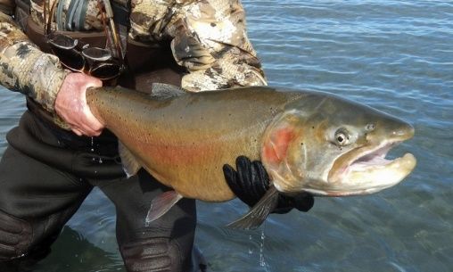
Pyramid Lake Paiute Tribe                      Washoe County Regional Hazard Mitigation Plan
                                                                        Jurisdictional Annex

                            THIS PAGE LEFT INTENTIONALLY BLANK
Pyramid Lake Paiute Tribe                                                           Washoe County Regional Hazard Mitigation Plan
                                                                                                               Table of Contents

TABLE OF CONTENTS
1. Introduction......................................................................................................................................... 1-1
      1.1     Pyramid Lake Paiute Tribal Hazard Mitigation Program ............................................................ 1-1
      1.2     What’s New in the 2020 Update? .............................................................................................. 1-1
      1.3     Plan Adoption............................................................................................................................. 1-2
2. Community Profile............................................................................................................................... 2-1
      2.1     Tribal Sovereignty and Governance ........................................................................................... 2-1
      2.2     Geography and Climate ............................................................................................................. 2-1
      2.3     Population and Demographics ................................................................................................... 2-1
      2.4     Tribal Enterprises ....................................................................................................................... 2-2
      2.5     Tribal Lands and Ownership Trends........................................................................................... 2-3
      2.6     Natural Resources ...................................................................................................................... 2-4
3. Hazard Profiles and Vulnerability Asessments .................................................................................... 3-1
      3.1     General ....................................................................................................................................... 3-1
      3.2     Hazard Ranking Methodology.................................................................................................... 3-2
      3.3     Hazard-Specific Profiles and Risk Assessments.......................................................................... 3-2
               3.3.1       Wildland Fire................................................................................................................. 3-4
               3.3.2       Flooding ........................................................................................................................ 3-5
               3.3.3       Earthquake.................................................................................................................... 3-8
               3.3.4       Energy Emergency ...................................................................................................... 3-10
               3.3.5       Drought ....................................................................................................................... 3-11
      3.4     Vulnerability Assessment ......................................................................................................... 3-13
               3.4.1       Asset Inventory ........................................................................................................... 3-13
               3.4.2       Repetitive Loss Properties .......................................................................................... 3-13
               3.4.3       Exposure Assessment ................................................................................................. 3-14
      3.5     Land Use and Development Trends ......................................................................................... 3-16
4. Capability Assessment ......................................................................................................................... 4-1
      4.1     Human and Technical Resources ............................................................................................... 4-1
      4.2     Financial Resources .................................................................................................................... 4-2
      4.3     Legal and Regulatory Resources ................................................................................................ 4-4
      4.4     National Flood Insurance Program Participation ....................................................................... 4-7
Pyramid Lake Paiute Tribe Washoe County Regional Hazard Mitigation Plan
Table of Contents
4.5 Integration of Mitigation into Existing Planning Mechanisms ................................................... 4-7
4.5.1 Existing Plans ................................................................................................................ 4-7
5. Mitigation Strategy .............................................................................................................................. 5-1
5.1 Review of 2015 Hazard Mitigation Actions ................................................................................ 5-1
5.2 2020-2025 Mitigation Implementation Plan ............................................................................. 5-1
6. References ........................................................................................................................................... 6-1Pyramid Lake Paiute Tribe Washoe County Regional Hazard Mitigation Plan
1. Introduction
1. INTRODUCTION
1.1 Pyramid Lake Paiute Tribal Hazard Mitigation Program
The Pyramid Lake Paiute Tribe (PLPT or Tribe) has a fully integrated approach to hazard mitigation
planning and program implementation. Throughout the 2020 update process, the following Hazard
Mitigation Plan (HMP) participation roles were recorded:
Name Position Role in Hazard Mitigation
Don Pelt Emergency Response Coordinator Mitigation Program Lead
Cassandra Darrough Advanced Emergency Medical Technician Subject Matter Expert and program
implementation
1.2 What’s New in the 2020 Update?
With the 2020 HMP update, Washoe County and its regional partners have recognized changes in
planning priorities by placing an added emphasis on incorporating actionable strategies in the mitigation
implementation plan and moving away from including ongoing coordination activities. Recent disasters
and emerging hazards have also influenced the planning priorities and development of mitigation
actions for the 2020 HMP update.
In the years since the release of the 2015 HMP, the Tribe has continued to implement strategies to
reduce its vulnerability to hazards, including development of renewable energy projects on the Pyramid
Lake Reservation, and has managed long-term recovery efforts from the 2017 flooding that significantly
impacted the Tribe’s main source of revenue, Pyramid Lake. The 2020 HMP update includes mitigation
actions intended to address vulnerabilities identified following the 2017 flooding.
The 2020 update of the Washoe County Regional HMP includes the following major revisions to the
2015 plan:
Incorporation of additional hazards and more comprehensive risk assessments (see Chapter 3);
Expanded capability assessment (see Chapter 4);
Integration of hazard mitigation planning into existing mechanisms (see Section 4.5); and
Comprehensive and focused mitigation strategy with prioritized mitigation actions (see Chapter
5).
See Appendix C of the Basic Plan for the completed Federal Emergency Management Agency Local Plan
Mitigation Review Tool for the Washoe County Regional HMP.
1-1Pyramid Lake Paiute Tribe Washoe County Regional Hazard Mitigation Plan
1. Introduction
1.3 Plan Adoption
44 CFR §201.6(c)(5) requires that the HMP be formally adopted by elected officials from each
participating jurisdiction. Tribal Council formally adopted the 2020 update of the Washoe County
Regional HMP on [Date].
This HMP was approved by FEMA Region IX on [Date]. A copy of the Tribe’s adoption resolution is
included in Appendix H of the Basic Plan.
1-2Pyramid Lake Paiute Tribe Washoe County Regional Hazard Mitigation Plan
2. Community Profile
2. COMMUNITY PROFILE
2.1 Tribal Sovereignty and Governance
The following governance information is provided from the Tribe’s website (as well as within the
Constitution and By-Laws of the Pyramid Lake Paiute Tribe):
The Pyramid Lake Paiute Tribe is governed by 10 Tribal Council members who are
elected bi-annually in December and on staggered two-year terms. The Tribe operates
under the Indian Reorganization Act Constitution and By-Laws approved on January 26,
1936 by the Department of Interior.
The Pyramid Lake Paiute Tribe has a Government to Government Relationship with the
Federal Government. Therefore, the Tribe contracts with or receives grants directly
from Federal Agencies or the State of Nevada, to provide services to the Tribal members
and residents of the Reservation. The revenue generated by the Tribe is used to support
local Tribal government activities and to supplement the programs that provide direct
services to the Tribal members or residents. (Pyramid Lake Paiute Tribe 1996-2004)
2.2 Geography and Climate
The Pyramid Lake Reservation is located 35 miles northeast of Reno, in a remote desert area. The
reservation contains about 475,000 acres, of which approximately 112,000 acres cover the surface of a
terminal desert lake, Pyramid Lake. This lake is the geographic sink of the basin of the Truckee River, and
is located 40 miles northeast of Reno. It is one of the most valuable assets of the Tribe and is entirely
enclosed within the boundaries of the reservation. Pyramid Lake, one of the largest natural lakes in the
state of Nevada, is approximately 15 miles long and 11 miles wide. The lake measures 350 feet at its
deepest point.
Based on data from 1967 to 2016 from the Western Regional Climate Center, the average precipitation
based on Sutcliffe, Nevada—located on the shore of Pyramid Lake—is 7.3 inches per year, and an
average 5.5 inches of snowfall annually. Temperatures average the upper 80s and lower 60s (degrees
Fahrenheit [°F]) in July and August and reach an average high and low of mid 40s (°F) and upper
20s/lower 30s (°F) in January and February. (WRCC n.d.)
2.3 Population and Demographics
The 2013–2017 American Community Survey 5-year estimates report a population of 1,504 people
within the Pyramid Lake County Subdivision (CCD), which encompasses about 714 acres of land,
including reservation land within Washoe County (U.S. Census Bureau 2017). As of February 2017, 1,300
people lived on the reservation. Approximately 10% of the reservation’s population lived in Sutcliffe,
33% in Nixon, and 57% in Wadsworth. The PLPT has approximately 2,288 enrolled members. The
membership statistic is an approximate number as this total changes from month to month based on
membership approvals and other actions taken by the 10-member Tribal Council. The majority of
enrolled Tribal members reside on the reservation; approximately 12% of this membership resides in
2-1Pyramid Lake Paiute Tribe Washoe County Regional Hazard Mitigation Plan
2. Community Profile
other areas throughout the Western United States. The majority of the reservation resident population
is young, comprised of individuals under the age of 35. The median age is 22.
The 2013–2017 American Community Survey 5-year estimates that approximately 43% of the popular-
tion over 16 years old within the Pyramid Lake CCD was employed, and the unemployment rate in the
CCD was approximately 21% (U.S. Census Bureau n.d.). Per capita income in the Pyramid Lake CCD was
approximately $17,597, about half of the per capita income in Washoe County of $31,879, and approxi-
mately 24% of people living in the CCD lived below the poverty line (U.S. Census Bureau 2017).
2.4 Tribal Enterprises
Much of the economy on the Pyramid Lake Reservation is centered on fishing and recreational activities
at Pyramid Lake. The lake is fed primarily by the Truckee River and was named one of the best fisheries
in the world by Fly Fishing and Tying Journal in 2010. In addition to permit fees for fishing, day use and
overnight camping, the Tribe also receives lease revenue and tax revenue. Several Tribal members
belong to the Pyramid Lake Cattleman’s Cooperative Association, and the Association utilizes the
reservation desert open range to operate and manage the individual cattle herds.
Per its website, the Tribal Council is advancing implementation of the Tribe’s Economic Development
Plan and accessing the Pyramid Lake Paiute Economic Development Fund created by Public Law 101-
618, signed into law under President George H.W. Bush in 1990. The $40,000,000 fund was created
when Congress passed the Truckee-Carson-Pyramid Lake Water Rights Settlement Act (PL 101-618) to
address legal disputes over the waters of the Truckee River and Pyramid Lake (which were significantly
impacted by construction of the Derby Dam in 1905). The Tribe’s economic development plan imple-
mentation process is a long-term effort that has involved adoption of a 2-volume Pyramid Lake
Economic Development Plan (approved in 2011), coordination with the federal government, numerous
opportunities for Tribal education and input into the process, and that results in economic stimulus
payments distributed directly to Tribal members.
In 2018 the Tribe was approved by the Bureau of Indian Affairs to withdraw 50% of the Pyramid Lake
Paiute Economic Development Fund’s interest. A press release issued by Tribal Chairman Vinton Hawley
in April 2018states that per Economic Development Plan, Vol. 2, all living members are entitled to equal
economic stimulus payment from the withdrawal, which equated to 1,875 adults and 1,042 minors.
The lump sum payment to adults from the fund is intended to stimulate Tribal enterprise over time, as
referenced in the Economic Development Plan: “The purpose of the plan is to use the Pyramid Lake
Paiute Economic Development Fund created by Public Law 101-618 to create long term profit making
opportunities, to create optimum employment opportunities and to establish a high quality recreation
area at Pyramid Lake for the Tribe and its members.”
The Tribe has also received federal funds recently through a 2018 award from the U.S. Environmental
Protection Agency for investment in environmental programs. Per the EPA, “The Pyramid Lake Paiute
Tribe will use $203,200 to model and evaluate the impact of Truckee River nutrient loads on Pyramid
2-2Pyramid Lake Paiute Tribe Washoe County Regional Hazard Mitigation Plan
2. Community Profile
Lake’s water quality, ecology, and trophic status. Funds will also support the cleanup and closure of
three illegal dump sites and assess the operations of several transfer stations to reduce illegal dumping.”
Per a 2016 profile on the website’s economic development page, 274 kilowatts of solar facilities have
been installed on the reservation, and the Tribe is working with the University of Nevada, Reno and
Desert Research Institute to develop a utility-scale geothermal project. The Tribe also was awarded a
$9.5 million American Recovery and Reinvestment Act stimulus grant to build a fiber optic cable line to
bring broadband internet to households and businesses.
Tourism is an important source of revenue for the Tribe; in 2015 the Tribe estimates over 200,000
visitors to Pyramid Lake.
BUSINESS HIGHLIGHTS
Much of the economy on the Pyramid Lake
Reservation is centered on fishing and
recreational activities at Pyramid Lake.
Pictured here is the I80 Smokeshop and Campground. Pictured is a Lahonton cutthroat trout caught in
The Paiute Tribe also operates the Big Bend RV Park. Pyramid Lake. Photo credit U.S. Fish and
Wildlife Service via AP.
2.5 Tribal Lands and Ownership Trends
The reservation land was first set aside for the Northern Paiute by request of the Bureau of Indian
Affairs in 1859. The reservation was not surveyed until 1865. The status of the reservation was very
uncertain until President Ulysses S. Grant affirmed its existence by Executive Order on March 23, 1874.
At that time, the creation of reservations by the executive branch was novel—most previous reserva-
tions were created by treaty or congressional legislation. Subsequent court decisions have affirmed the
validity of reservations created by the executive branch, and have set the establishment date for the
Pyramid Lake Reservation at 1859, not 1874. This earlier date is important both with regards to the
priority date of Tribal water rights, and the status of non-tribal claims to land within the reservation. The
Tribe has fought a long series of legal battles on both of these issues.
With passage of the Nevada Native Nations Land Act in 2016, 6,357 acres of land managed by Bureau of
Land Management was transferred to be held in trust for the Pyramid Lake Paiute Tribe. This expanded
upon the nearly half-million acres already contained within the Pyramid Lake Reservation, with the
2-3Pyramid Lake Paiute Tribe Washoe County Regional Hazard Mitigation Plan
2. Community Profile
intention of further incorporating the watershed of Pyramid Lake into Tribe ownership, and for potential
economic development opportunity.
2.6 Natural Resources
The Tribe’s connection to its natural resources is expressed in its website. “Deeply grounded in their
environment, the Paiutes believed that power (pooha) could reside in any natural object including
animals, plants, stones, water and geographical features.”
Pyramid Lake features riparian ecosystems, agricultural lands, rangelands, and wetlands and has
numerous species of willows, tule, as well as, chokecherry and elderberries in canyons with perennial
streams and springs. Pine nuts are a traditional harvest food.
The reservation encompasses five Major Land Resource Areas and over 80 different ecological sites. The
Tribe’s Pyramid Lake Natural Resources Department aims to “preserve, protect, enhance, and restore
land, air, and water resources, and environmental health for the longer term sustainability of the natural
resources of the Pyramid Lake Indian Reservation” through “sound administration, ecological, cultural,
socioeconomic and educational methods to ensure that our future generations can continue to enjoy
the benefits of those places that are of significant historical, cultural, and of environmental importance”
(https://www.plptnaturalresources.org/).
The Natural Resource Department runs programs related to water resources, water quality, brownfields
response, air quality, and invasive species. Invasive species include saltcedar, tall whitetop, and Russian
olive; these species are displacing native cottonwoods, willows, and other riparian vegetation along the
lower Truckee River.
According to the website, Pyramid Lake itself is
known as North America’s most beautiful desert
lake. “Pyramid Lake was designated as the first
National Scenic Byway entirely on an Indian
reservation and has been recently named
Nevada’s first Preserve America Tribal Com-
munity. The lake occupies 112,000 surface acres
inside the reservation boundary and has a
shoreline of approximately 125 miles. The lake
has no outlet and is a residual body remaining
from the prehistoric Great Lake Lahontan water
body that covered most of Northwestern Nevada
thousands of years ago.”
Pyramid Lake and Truckee River provide habitat for the endemic
The lake is also home to the Anaho Island National
and endangered Cui-ui (pictured here) and threated Lahontan
Wildlife Refuge, which supports one of the largest
Cutthroat Trout.
breeding colonies of American white pelicans in
North America.
2-4Pyramid Lake Paiute Tribe Washoe County Regional Hazard Mitigation Plan
2. Community Profile
Pyramid Lake is home to five different species of fish: Lohanton cutthroat trout, cui-ui, Tahoe sucker, tui
chub, and Sacramento perch. Pyramid Lake is the only place on earth where the cui-ui can be found. In
2010 Pyramid Lake Fisheries replanted over 700,000 fish in the lake. Since 2006, Desert Terminus Lake
Program funds have been used to remodel the Numana, Dunn, and Big Bend fish hatcheries. Pyramid
Lake Fisheries micro tagged over 120,000 fish for research in 2010. Wildlife includes jack rabbits, which
were traditionally netted for food and clothing.
2-5Pyramid Lake Paiute Tribe Washoe County Regional Hazard Mitigation Plan
3. Hazard Profiles and Vulnerability Assessments
3. HAZARD PROFILES AND VULNERABILITY ASESSMENTS
Chapter 3 contains hazard profiles and vulnerability assessments to determine the potential impact of
hazards to the people, economy, and built and natural environments of the PLPT. The profiles have been
streamlined to increase the effectiveness and usability of the HMP. Additional details are provided in
Appendix F of the Basic Plan.
B1. Does the Plan include a description of the type, location, and extent of all natural
hazards that can affect the tribal planning area? (Requirement §201.6(c)(2)(i))
B2. Does the Plan include information on previous occurrences of hazard events and on the
probability of future hazard events for the tribal planning area? (Requirement §201.6(c)(2)(i))
B3. Does the plan include a description of each identified hazard’s impact as well as an
overall summary of the vulnerability of the tribal planning area? [44 CFR § 201.6(c)(2)(ii)]
3.1 General
Washoe County has experienced several major disaster declarations that may have affected the PLPT. In
total, the County has received 20 major disaster declarations, including four since the previous HMP
update. Table 3-1 identifies the declarations since 2015 that affected the Tribe.
Table 3-1 Major Disaster Declarations in Washoe County since 2015
Individual Public Hazard
Disaster Assistance Assistance Mitigation Declaration
Title
Number Program Program Program Date
Declared Declared Declared
4307 No Yes Yes 3/27/2017 Severe Winter Storms, Flooding, and
Mudslides
4303 No Yes Yes 2/17/2017 Severe Winter Storms, Flooding, and
Mudslides
4303 No Yes Yes 2/17/2017 Severe Winter Storms, Flooding, and
Mudslides
4303 No Yes Yes 2/17/2017 Severe Winter Storms, Flooding, and
Mudslides
Source: FEMA 2019
The hazard profiles and vulnerability assessments contained in this annex represent a considerable
amount of work performed by the Mitigation Planning Team (MPT). MPT members ranked hazards using
several key considerations, followed up by activities, to validate hazard analysis results and identify
specific areas of risk. Table 3-2 displays the hazards that Tribal representatives to the MPT selected for
further assessment.
3-1Pyramid Lake Paiute Tribe Washoe County Regional Hazard Mitigation Plan
3. Hazard Profiles and Vulnerability Assessments
Table 3-2 Hazards Addressed in the Plan
Hazard Type Hazard Name
Wildland Fire
Flooding
Natural Hazards
Earthquake
Drought
Technological Hazards Energy Emergency
3.2 Hazard Ranking Methodology
The hazards identified in the HMP were initially ranked based on MPT feedback during MPT Meeting #1.
Following the individual hazard ranking activity, the results were added up and aggregated to show an
average score for all PLPT MPT members (see Table 3-3).
3.3 Hazard-Specific Profiles and Risk Assessments
The following sections profile and assess the risks associated with hazards that are high planning
priorities for the PLPT, which are hazards that were scored an average of 3.00 or higher during the
hazard ranking activity. No natural hazards that have the potential to affect the tribe were omitted from
the initial hazard assessment and ranking activity. The hazard profiles and risk assessments align with
EMAP standards by focusing on hazards with a high magnitude or high probability. Each risk assessment
considers the following attributes:
Location: An indication of geographic areas that are most likely to experience the hazard.
Past Occurrences/History: Similar to location, a chronological highlight of recent occurrences of
the hazard accompanied by an extent or damage cost, if available.
Extent/Probability: A description of the potential magnitude of the hazard, accompanied by the
likelihood of the hazard occurring (or a timeframe of recurrence, if available).
Vulnerability: A description of the potential magnitude of losses associated with the hazard.
Vulnerability may be expressed in quantitative or qualitative values depending upon available
data. Identifies development trends impact on the Tribe’s vulnerability to each hazard since the
2015 plan development (increased, decreased, or unchanged).
Note: Hazard Descriptions, Potential Impacts from Future Climate Conditions, and Cascading Impacts can
be found in Chapter 4 of the HMP Basic Plan, as these are not place-specific.
3-2Pyramid Lake Paiute Tribe Washoe County Regional Hazard Mitigation Plan
3. Hazard Profiles and Vulnerability Assessments
Table 3-3 Pyramid Lake Paiute Tribe Hazard Rankings
Jurisdiction: Pyramid Lake Paiute Tribe - Hazards
Probability Magnitude Frequency Onset Duration Change in Risk
(1=lowest, (1=lowest, (1=lowest, (1=slowest, (1=shortest, (↑, ↓, ↔ Average Rank
5=highest) 5=highest) 5=highest) 5=fastest) 5=longest) since 2015)
Wildland Fire 5.00 3.00 5.00 5.00 4.00 1.00 4.40 1
Flooding 4.00 3.00 3.00 3.00 5.00 1.00 3.60 2
Earthquake 4.00 3.00 1.00 5.00 5.00 1.00 3.60 2
Energy Emergency 2.00 1.00 5.00 5.00 3.00 1.00 3.20 4
Drought 4.00 1.00 4.00 1.00 5.00 1.00 3.00 5
Severe Storms (Winter Storm) 2.00 1.00 5.00 3.00 3.00 0.00 2.80 6
Criminal Acts and Terrorism 2.00 2.00 4.00 5.00 1.00 1.00 2.80 6
Hazardous Materials Incident 2.00 1.00 1.00 5.00 5.00 -1.00 2.80 6
Infectious Disease 2.00 2.00 3.00 3.00 4.00 0.00 2.80 6
Avalanche and Landslide
(Landslide) 1.00 2.00 1.00 4.00 5.00 -1.00 2.60 10
Severe Storms (Windstorm) 2.00 1.00 4.00 3.00 2.00 0.00 2.40 11
Note: Radiological waste transport and volcano hazards were not initially ranked by the MPT. In subsequent meetings, these hazards were identified as low probability but
potentially high magnitude hazards. Risk assessments for both hazards are included in Section 4.5 of the basic plan. Avalanche and Landslide (Avalanche) and Transportation
Incident (Aircraft Crash) were not identified as hazards for the Tribe.
3-3Pyramid Lake Paiute Tribe Washoe County Regional Hazard Mitigation Plan
3. Hazard Profiles and Vulnerability Assessments
3.3.1 Wildland Fire
Wildland Fire
Probability Magnitude Frequency Onset Duration Average Rank
5.00 3.00 5.00 5.00 4.00 4.40 1
Location
The Tribe’s three communities, Sutcliffe, Nixon, and Wadsworth, are in or near areas of moderate to
very high wildland fire potential. The fire risk for Sutcliffe, in particular, is a concern for the Tribe
because Sutcliffe is within the Wildland‐Urban Interface (WUI). Growth of cheatgrass in burn scars on
the ridges west of Sutcliffe also increases the fire risk for this community. Cheatgrass is highly flam-
mable, and “densely growing populations [of cheatgrass] provide ample, fine-textured fuels that
increase fire intensity and often decrease the intervals between fires” (Colorado State University
Extension 2019). The topography of the ridges west of Sutcliffe also increases the fire risk to the
community; a wildland fire that starts west of Sutcliffe is likely to run down the ridge into the com-
munity. The PLPT pre-stages fire trucks at Sutcliffe during fire season in response to this risk.
Wildland fire potential ranges from moderate to very high along the ridges east and west of Pyramid
Lake, and wildland fires can impact recreation at the lake, an important source of revenue for the
Tribe, if closures are necessary to protect public safety or if visitors choose not to come to the lake
due to smoke or other conditions.
Past Occurrences/History
Recent wildland fires between 2015 and 2018 that have affected the Pyramid Lake Reservation are
listed below. In 2016, the Tule fire, part of the Virginia Complex fire, destroyed two travel trailers and
two vehicles, all unoccupied at the time.
Wildland Fires in or near the Pyramid Lake Reservation between 2015 and 2018
Year Fire Name Total Acres Burned Cause
Tule, part of the
2016 Virginia Mountains 36,142 Natural
Complex Fire
2017 Hollywood 5,298 Undetermined
2017 Black Mountain 961 Natural
2017 Truckee 98,960 Human
2018 Perry 51,386 Human
Source: https://gis.washoecounty.us/wrms
Extent and Probability
The Pyramid Lake Reservation is primarily rural with small population centers, ranchlands, and farm
fields in close proximity to the WUI. Wildland fires have the potential to directly affect Tribal com-
munities, destroying structures and resulting in injuries or deaths. Wildland fires on or near the
reservation also can result in economic impacts if the response to incidents requires the Tribe to close
the lake to fishing and recreation or if visitation decreases.
Wildland fires are frequent and inevitable. Within the region, the vast majority of wildland fires burn
from May to October. The PLPT representative to the MPT rated wildland fires as the highest
3-4Pyramid Lake Paiute Tribe Washoe County Regional Hazard Mitigation Plan
3. Hazard Profiles and Vulnerability Assessments
Wildland Fire
probability fire likely to affect the Tribe, and the Tribe generally experiences the effects of wildland
fire everyone to three years.
Future Probability Trend – Based on projected changes in the timing and quantity of snowmelt and
increases in the frequency and magnitude of drought and extreme heat, the Tribe may be impacted
by an increase in the probability of future wildland fires.
Vulnerability
Both Tribal members and their assets are generally located in or near the WUI. The challenges the
Tribe faces mitigating for wildland fire includes residential and commercial properties in close proxi-
mity to vegetation that provides fuel for wildland fires and large burns scars on and near the reserva-
tion that have been taken over by highly flammable invasive species like cheatgrass.
Existing Mitigation Case Study
In burn scars in the Virginia mountain range, the Tribe is installing landslide detection and warning
devices to address the potential cascading effects of recent fires. The Tribe also educates residents
about how to maintain defensible space on their properties.
Property
Six identified critical facilities on the Pyramid Lake Reservation are in areas with very low
wildland fire hazard potential.
Recent Development Trends
Economic: The Tribe has not developed any additional economic holdings in areas prone to
fire events. (Unchanged Vulnerability)
Land Use: Ridge areas south and east of Pyramid Lake, which are part of the 6,357 acres of
land transferred to be held in trust for the Tribe under the Nevada Native Nations Land Act of
2016, have a moderate to very high potential for wildland fire. (Increased Vulnerability)
Future Land Use
No new development is planned within moderate to high fire risk areas.
See Appendix F1 of the Basic Plan for a full Risk Exposure Table and Appendix F2 of the Basic Plan for
maps.
3.3.2 Flooding
Flooding
Probability Magnitude Frequency Onset Duration Average Rank
4.00 3.00 3.00 3.00 5.00 3.60 2
Location
The final segment of the lower Truckee River Basin lies below Wadsworth and includes a 25-mile-long
broad, alluvial valley stretching to Pyramid Lake. Floodplains within the Pyramid Lake Reservation
have not been mapped; however, the PLPT is at risk from riverine flooding in low-lying areas along the
Truckee River and along the immediate shoreline of the lake. The Tribe also experiences the effects of
3-5Pyramid Lake Paiute Tribe Washoe County Regional Hazard Mitigation Plan
3. Hazard Profiles and Vulnerability Assessments
Flooding
localized flooding caused by heavy rains that flood irrigation canals and creeks or cause sheet flows
across burn scars from recent wildland fires or other areas with little vegetation. Creeks in areas
impacted by recent wildland fires, including Rodero Creek, Hardscrabble Creek, Anderson Creek, and
Mullens Creek, are particularly at risk for flash flooding. An alluvial fan south of Sutcliffe is also prone
to flooding, and flooding in this area can cut off access to Sutcliffe from the south due to debris or
damage to Highway 446.
In 2019, the water level in Pyramid Lake rose by about 3 feet. While there is room for water levels to
increase further before the Tribe experiences any impacts, higher water levels are eroding a section
of the shoreline near Sutcliffe RV Park and a fish hatchery—two of the Tribe’s economic enterprises.
Continued erosion near Sutcliffe is a concern for the Tribe. Flooding in Pyramid Lake also can destroy
docks and other infrastructure on the water that supports recreational use of the lake, resulting in
economic impacts for the Tribe.
Past Occurrences/History
The PLPT planning team contributed the following information on recent floods affecting the reserva-
tion. This serves as additional information to the past flooding occurrences that may have affected
the Pyramid Lake Reservation, listed in Section 4.5.2 of the Basic Plan.
In 2017, the Truckee River and streams flowing into Pyramid Lake flooded. Flows in the Truckee River
reached several feet above flood stage, affecting areas of Wadsworth and Nixon south of Pyramid
Lake. The Tribe was able to avoid some impacts by sandbagging around areas expected to flood;
however, several residential areas needed to be evacuated and ranchlands and farm fields were
inundated. The affected agricultural areas were out of use for a long time, which resulted in an
extended economic impact on Tribal farmers and ranchers.
Creeks on the western side of the lake “turned into rivers” during the flooding. Homes in Sutcliffe that
sit on Hardscrabble Creek had to be evacuated, and the alluvial fan south of Sutcliffe flooded, which
caused power and water service outages and washed out Highway 446 from its junction with Highway
445 south to Popcorn Rock, cutting off access to Sutcliffe from reservation communities to the south
at times. For a week, Tribal staff transported water from nearby water systems to Sutcliffe for
residents’ use while temporary repairs were being completed. The Tribe’s Emergency Services/Fire
Department also pre-positioned a mobile clinic to help homebound patients in Sutcliffe while roads
were impassible.
The 2017 flooding significantly affected roads through the reservation. As noted above, a portion of
Highway 446 was washed out, and the community of Sutcliffe could only be accessed from Wads-
worth and Nixon by detouring south on Highway 447, then taking Interstate 80 to Reno and Highway
445 north to Sutcliffe. The highway was shut down for about a year, isolating this part of the reserva-
tion and affecting truck traffic through Washoe County. Two families on County land (Big Canyon and
Raven Ranch) north of Sutcliffe were also cut off when Highway 446 was washed out and had to be
evacuated by helicopter.
The 2017 flooding resulted in economic impacts to the Tribe that are still being felt two years later. As
a result of the flooding, the Tribe had to shut down recreational use of the lake during prime fishing
season, which affected revenues from fishing permits. Flooding washed out roads, beaches, and
3-6Pyramid Lake Paiute Tribe Washoe County Regional Hazard Mitigation Plan
3. Hazard Profiles and Vulnerability Assessments
Flooding
docks along the lake, affecting recreational access, and areas of the shoreline are still closed where
access has been blocked by boulders. The Tribe does not have funding to restore access to these
areas. Two docks in Sutcliffe and on the southern end of the lake also have not been replaced.
In 2018, flash floods occurred along the western shoreline of the lake and temporarily covered High-
way 445 with mud and debris. Surface flow flooding coming off the burn scar from the Perry fire,
which burned 51,386 acres in the Pah Rah range, also affected Tribal lands in 2018.
Extent and Probability
Severe floods may result in serious injuries and deaths, as well as damage to public facilities and
private property. The extent of flooding can be determined by the height of river flows in comparison
to flood stages determined by U.S. Geological Survey stream gauges located throughout the area. It
can also be measured by past damages of flooding.
The PLPT may experience limited, localized flooding on an annual basis. Major riverine floods have
occurred approximately once a decade, and major alluvial fan floods have occurred approximately
once every 20 years.
Future Probability Trend – Based on a potential increase in high-intensity precipitation events and
increased probability of wildland fires, the Tribe may be impacted by an increase in the probability of
future floods and flash flooding.
Vulnerability
The majority of flooding in the vicinity of Tribal properties results in the washout or flooding of
roadways and infrastructure within the floodway, such as culverts or docks. Following a flood,
damage to infrastructure can severely disrupt the Tribe by cutting communities off from one another,
for example, the way Sutcliffe was isolated from Nixon and Wadsworth following the 2017 floods;
damaging utilities; or by impacting recreational use of Pyramid Lake. Vulnerable members of the
Tribe, such as the elderly and those with medical conditions, are at an increased risk if roadways are
closed following a flood and access is restricted for emergency medical services. In addition, homes
and businesses on the reservation, particularly those in Sutcliffe, are at risk of damage from floods.
None of the identified critical facilities on the Pyramid Lake Reservation are within the 100-
year or 500-year flood zones.
Recent Development Trends
Economic: No new economic enterprises are planned or proposed that would increase the
Tribe’s vulnerability to flooding. (Unchanged Vulnerability)
Land Use: Lands transferred to be held in trust for the Pyramid Lake Paiute Tribe under the
Nevada Native Nations Land Act are not at a significant risk for riverine flooding. However,
these parcels may be at risk of sheet flow or flash flooding, especially following wildland fires.
(Increased Vulnerability)
Future Land Use
The Tribe’s planned community center would not be located within any known floodplains.
See Appendix F1 of the Basic Plan for a full Risk Exposure Table and Appendix F2 of the Basic Plan for
maps.
3-7Pyramid Lake Paiute Tribe Washoe County Regional Hazard Mitigation Plan
3. Hazard Profiles and Vulnerability Assessments
3.3.3 Earthquake
Earthquake
Probability Magnitude Frequency Onset Duration Average Rank
4.00 3.00 1.00 5.00 5.00 3.60 2
Location
The Pyramid Lake Reservation overlies a major fault, the Pyramid Lake Fault Zone, and multiple
smaller faults, one of which runs beneath the lake. Another fault lies below the community of Nixon.
During an earthquake, the developed areas of the reservation may experience severe seismic ground
motion hazards. These hazards are summarized below for different areas of the reservation:
Areas of the reservation north and east of Pyramid Lake – May experience peak ground
acceleration with a 2% probability of exceedance in 50 years of between 32 and 48% gravity,
which would be experienced as very strong to severe shaking capable of causing moderate to
heavy damage.
Areas of the reservation west of Pyramid Lake between Sutcliffe and Wizard Cove, the west-
ern half of Sutcliffe, Nixon, and Wadsworth – May experience peak ground acceleration with
a 2% probability of exceedance in 50 years of between 48 and 64% gravity, which would be
experienced as severe shaking capable of causing moderate to heavy damage.
Eastern half of Sutcliffe and most of the lake’s eastern shoreline south of Sutcliffe – May
experience peak ground acceleration with a 2% probability of exceedance in 50 years of over
64% gravity, which would be experienced as violent shaking with the potential to cause heavy
damage.
Seismic ground motion hazards on the reservation are shown on Figures F-3 and F-4 in Appendix F of
the Basic Plan.
Past Occurrences/History
Information on previous major earthquakes with magnitudes greater than 5 on the Modified Mercalli
Intensity Scale in Washoe County is included in Section 4.5.4 of the Basic Plan. Shaking from these
earthquakes would have been felt on the Pyramid Lake Reservation and may have caused structural
damage.
Members of the PLPT planning team reported that multiple small earthquakes magnitude 2 or less
have occurred on the fault running below Pyramid Lake within the past year.
Extent and Probability
A major earthquake has the potential to cause widespread and significant damage to structures on
the Pyramid Lake Reservation, injuries, and deaths. Because of their potential to cause damage to
structures, roads, and utilities, earthquakes may disrupt government operations and the local
economy for a period of days to weeks and may require evacuations or create increased demand for
emergency medical services. Response to and recovery from an earthquake may require federal
support.
Future Probability Trend – A total of 17 earthquakes with a magnitude greater than 5 on the Modi-
fied Mercalli Intensity Scale have occurred in Washoe County in the last 150 years. The probability of
future occurrence can be estimated at 10%; this means that there is roughly a 10% chance of an
3-8Pyramid Lake Paiute Tribe Washoe County Regional Hazard Mitigation Plan
3. Hazard Profiles and Vulnerability Assessments
Earthquake
earthquake with magnitude >5 to occur every year. Climate, economic, and land use trends do not
affect the probability of an earthquake; however, economic trends and land use patterns can affect
the amount of damage caused by an earthquake. While the Tribe is not planning significant areas of
new development, the increasing age of Tribal buildings increases the probability that future
earthquakes will result in damage to structures, roads, and utilities.
Vulnerability
None of the Tribal buildings or residences on the reservation have been retrofitted to meet seismic
standards. Because of the age of the buildings, it would be more cost effective for the Tribe to
demolish the buildings and construct new facilities to seismic standards.
There is a potential for a large earthquake centered below Pyramid Lake to cause a seiche. No studies
have been completed to determine which areas of the reservation may be impacted by a seiche, so
the Tribe’s level of vulnerability to this hazard is not known.
The Paiute Pipeline, which carries gasoline, diesel fuel, and jet fuel, runs through Dodge Flats and
crosses the southern part of the reservation to meet Interstate 80. An earthquake centered on or
near the reservation could damage this pipeline and cause additional impacts to the reservation.
Property
Four critical facilities on the reservation, including the Pyramid Health Center, two schools,
and one dam, are located in areas vulnerable to seismic ground motion hazards with a 2%
probability of being exceeded in 50 years of between 48 and 64% gravity. This level of ground
shaking would be experienced as severe shaking with the potential to cause moderate to
heavy damage.
Two schools on the reservation are in areas vulnerable to seismic ground motion hazards with
a 2% probability of being exceeded in 50 years of greater than 64% gravity. This level of
shaking would be experienced as violent shaking with the potential to cause heavy damage.
All of the identified critical facilities on the reservation are in areas vulnerable to seismic
ground motion hazards with a 10% probability of being exceeded in 50 years of 32 to 48%
gravity. This level of shaking would be experienced as very strong to severe shaking capable of
producing moderate to heavy damage.
Recent Development Trends
Economic: Limited economic development has occurred in the past five years. (Unchanged
vulnerability)
Land Use: Construction of the proposed community center outside of Wadsworth may in-
crease the Tribe’s vulnerability to earthquakes if this facility is not constructed to current
seismic standards. (Increased Vulnerability)
Future Land Use
Future development on the reservation would be vulnerable to damage from earthquakes and
secondary hazards like seiches.
See Appendix F1 of the Basic Plan for a full Risk Exposure Table and Appendix F2 of the Basic Plan for
maps.
3-9Pyramid Lake Paiute Tribe Washoe County Regional Hazard Mitigation Plan
3. Hazard Profiles and Vulnerability Assessments
3.3.4 Energy Emergency
Energy Emergency
Probability Magnitude Frequency Onset Duration Average Rank
2.00 1.00 5.00 5.00 3.00 3.20 4
Location
The Pyramid Lake Reservation is in a fringe area of the regional electrical grid. All Tribal properties
that rely on the electrical grid for power are vulnerable to power outages. Electrical power from the
grid is supplied to the Tribe via one transmission line between the community of Tracy Clark and
Sutcliffe.
Past Occurrences/History
Historically, power outages have been caused by natural events and human-caused accidents, but
have not been recorded in a way that is publicly accessible. Numerous power outages occur every
year and may last as short as hours or as long as weeks. In 2015, the single transmission line running
over the mountains from the community of Clark to supply power to Sutcliffe and the rest of the
reservation (the Tribe’s “extension cord”) went down during a winter storm. The power outage
caused by the storm lasted for about four days and affected the entire reservation. The outage occur-
red at an isolated and difficult to access point along the transmission line route in the mountains. To
access this point, the power provider had to use snow cats, which had difficulty passing muddy parts
of the access road. These access issues delayed repair of the line and contributed to the length of the
power outage.
Interruptions in energy services may also be planned—for example, to allow for system repairs or
maintenance. In 2019, NV Energy began implementing extensive public safety outage management
programs in areas with extreme fire risks. To prevent downed power lines and damaged equipment
from causing fires, NV Energy may de-energize parts of the electrical grid during weather conditions
conducive to wildland fires (e.g., high temperatures, low humidity, high winds, lightning storms) or
based on field observations or information from first responders (NV Energy 2019). Planned outages
by NV Energy or Pacific Gas and Electric Company (PG&E) in California have the potential to affect fuel
availability for the Tribe. Outages affecting PG&E’s system would cut power to the equipment that
controls operation of the fuel pipeline serving the region.
Extent and Probability
It is difficult to predict the impacts of future energy emergencies, but they have the potential to
impact all Tribal government and business operations, cause extensive economic losses, and in-
crease needs for emergency medical care among other impacts. Due to the sporadic nature of
power outages and other energy emergencies, it is also difficult to estimate how frequently these
emergencies will occur or their duration. The Tribe generally deals with power outages multiple
times per year with many of them only lasting a matter of hours. Every several years, a large power
outage is experienced, primarily due to winter storms.
3-10Pyramid Lake Paiute Tribe Washoe County Regional Hazard Mitigation Plan
3. Hazard Profiles and Vulnerability Assessments
Energy Emergency
Future Probability Trend – The Tribe is not planning significant areas of new development and has
been working to install solar arrays on the reservation to reduce its vulnerability to power outages.
A transfer switch will need to be installed to ensure that the Tribe’s solar arrays can continue to
provide power if the transmission line to the reservation goes down. Based on these factors, the
probability of longer power outages on the reservation may decrease if a transfer switch is
installed.
Vulnerability
A lack of redundancy in the power system presents a clear risk to Tribal members, businesses, and
government operations, due to the Tribe’s reliance on a single transmission line that traverses
remote, difficult terrain. An outage along this line affects the entire reservation, including the Tribal
office, clinic, and emergency services, which have to fully or partially shut down during outages. There
are few backup power generators on the installation, so Tribal elders and those who are dependent
on medical equipment are especially vulnerable to power outages. The Tribe is taking measures to
address this vulnerability through the mitigation actions outlined in Chapter 5.
Recent Development Trends
Economic: The Tribe has outlined mitigation actions to address electricity redundancy and
decrease reliance on surrounding utilities. (Decreased Vulnerability)
Land Use: Construction of the planned community center will increase the overall demand for
electric power. (Increased Vulnerability)
Future Land Use
The Tribe will continue to invest in renewable energy projects as resources become available to
reduce its vulnerability to power outages.
3.3.5 Drought
Drought
Probability Magnitude Frequency Onset Duration Average Rank
4.00 1.00 4.00 1.00 5.00 3.00 4
Location
Drought affects broad regions and can affect the entire Pyramid Lake Reservation. Historically, the
central and northern parts of Washoe County have experienced more frequent droughts than the
southern part of the county, due to extensive stored water in reservoirs in the Truckee River basin in
southern Washoe County. Low snowpack in the Truckee River basin can result in droughts of greater
magnitude in the southern part of the county, as was experienced during drought conditions between
2012 and 2017.
3-11Pyramid Lake Paiute Tribe Washoe County Regional Hazard Mitigation Plan
3. Hazard Profiles and Vulnerability Assessments
Drought
Past Occurrences/History
Drought conditions are frequently recorded in Washoe County. According to information from the
U.S. Drought Monitor, Washoe County and the PLPT have experienced several periods of drought
since 2000 (Figure 3-1). Since 2000, more often than not, the county has been subject to drought and
often severe or worse drought. Three pronounced but relatively brief wet periods are noted, from
2005-2006, 2011-2012, and in 2017, during which the region saw particularly wet/snowy winters,
including major floods in December 2005 and February and March 2017. This is a clear example of the
variable climate in Washoe County.
Figure 3-1 United States Drought Monitor Time Series for Washoe County
See Section 4.5.9 of the Basic Plan for more details.
Extent and Probability
The overall magnitude and potential severity of drought is considered Moderate for the PLPT.
Drought impacts are wide-reaching and may be economic, environmental, and/or societal.
Droughts lasting for a period of several years or more may affect the Tribe’s economic enterprises,
including ranching and recreation at Pyramid Lake.
Typical drought events are handled at the regional level by all jurisdictions and by both public (e.g.,
Truckee Meadows Water Authority) and private water suppliers, and can have economic impacts on
the Tribe and county as well as the state. Disruption of services is highly variable: in urban areas with
municipal water systems and reservoir storage, disruption may be quite minimal during a typical few-
year drought. In that same drought, however, disruption of water supplies to rural and agricultural
communities in Washoe County may be considerable as those areas depend more on ground water,
which can be depleted quickly in drought conditions.
Considering a worst-case scenario, a decade-long drought can require federal support, impact
critical facilities, disrupt water services to both urban and rural populations, and have national
economic impacts. The length or nature of disruption is variable ranging from the cessation of all
agricultural production to severe water restrictions in urban communities.
Future Probability Trend – Drought is one of the least predictable hazards. The current state of
seasonal weather prediction science is such that it is nearly impossible to predict well in advance
the beginning or the ending of droughts with meaningful confidence levels. With that said, periods
of drought have regularly occurred in the recent history of Washoe County and Nevada; therefore,
drought can be expected to occur with some regularity in the future. Based on the assessments in
3-12Pyramid Lake Paiute Tribe Washoe County Regional Hazard Mitigation Plan
3. Hazard Profiles and Vulnerability Assessments
Drought
the previous sections, the probability of a future severe drought event is considered High, with an
approximately 50% chance of occurrence in any given year.
Vulnerability
The economic impacts of drought for the Tribe can range from crop losses and increased costs incur-
red by farmers and ranchers who need to buy additional water or feed for livestock to economic
losses resulting from decreased recreational use of Pyramid Lake or the need to close access to the
lake to protect natural values. The effects of drought can last from one to multiple years, and the
economic and social effects of drought are likely to be compounded the longer drought conditions
last.
Recent Development Trends
Economic: The relationship between the Tribe’s economic enterprises and drought has not
changed in recent years. (Unchanged vulnerability)
Land Use: The Tribe relies on Pyramid Lake for a large portion of its revenues. The lake’s
vulnerability to drought has not changed in recent years. (Unchanged vulnerability)
Future Land Use
The Pyramid Lake Economic Development Plan sets goals for new agricultural and ranching enter-
prises on the reservation. These enterprises would be more vulnerable to the effects of drought and
may increase the vulnerability of the Tribe to economic losses caused by drought.
3.4 Vulnerability Assessment
3.4.1 Asset Inventory
Local assets that may be affected by hazards include members of the Tribe, properties, and utilities and
infrastructure. Geographic information system (GIS) data from federal, state, and local databases was
used to inform the vulnerability assessment and identify critical infrastructure. Section 4.4.2 and
Appendix F1, both in the Basic Plan, discuss the sources and types of data used in the HMP. Data collec-
tion for the vulnerability assessment was complicated by the fact that the region has never compre-
hensively identified critical infrastructure; therefore, the list of critical infrastructure on the Pyramid
Lake Reservation may be incomplete. Similarly, valuation information has not been compiled by the
region, so valuation data was not available to be included in the vulnerability assessment. Washoe
County and its partners are committed to continuing to refine and build on the list of critical infrastruc-
ture over the next five years to improve the data provided in the next plan update.
3.4.2 Repetitive Loss Properties
The Tribe does not participate in the National Flood Insurance Program (NFIP). Due to the fact that the
Tribe does not participate in NFIP, the Tribe does not maintain a repetitive loss property inventory that
meets the Repetitive Loss or Severe Repetitive Loss criteria.
3-13Pyramid Lake Paiute Tribe Washoe County Regional Hazard Mitigation Plan
3. Hazard Profiles and Vulnerability Assessments
3.4.3 Exposure Assessment
Table 3-4 shows exposure of the Tribe’s identified critical facilities to natural hazards that are able to be
mapped.
3-14Pyramid Lake Paiute Tribe Washoe County Regional Hazard Mitigation Plan
3. Hazard Profiles and Vulnerability Assessments
Table 3-4 Exposure Assessment
Seismic
Seismic
Ground Wildland Fire
Ground
Motion Landslide Hazard
Type Name Address Jurisdiction Flood Zone 1
Motion
Hazards with Susceptibility Potential
Hazards with
10% (scale 1-6)
2% Probability
Probability
Pyramid Health Pyramid Lake
Hospital N/A -- 48-64 32-48 low 1
Center Paiute Tribe
Trinity Valley Pyramid Lake
School N/A -- 64+ 32-48 mod 1
Elementary School Paiute Tribe
1 NV-447, Pyramid Lake
Natchez Elementary
School Wadsworth, NV Paiute Tribe -- 48-64 32-48 low 1
School
89442
Sutcliffe School Pyramid Lake
School N/A -- 64+ 32-48 mod 3
(historical) Paiute Tribe
Pyramid Lake High 711 State St., Pyramid Lake
School -- 48-64 32-48 low 1
School Nixon, NV 89424 Paiute Tribe
Notes:
1 None of the identified critical facilities on the Pyramid Lake Reservation are located within mapped flood zones.
Key:
N/A = Information not available
3-15You can also read